···
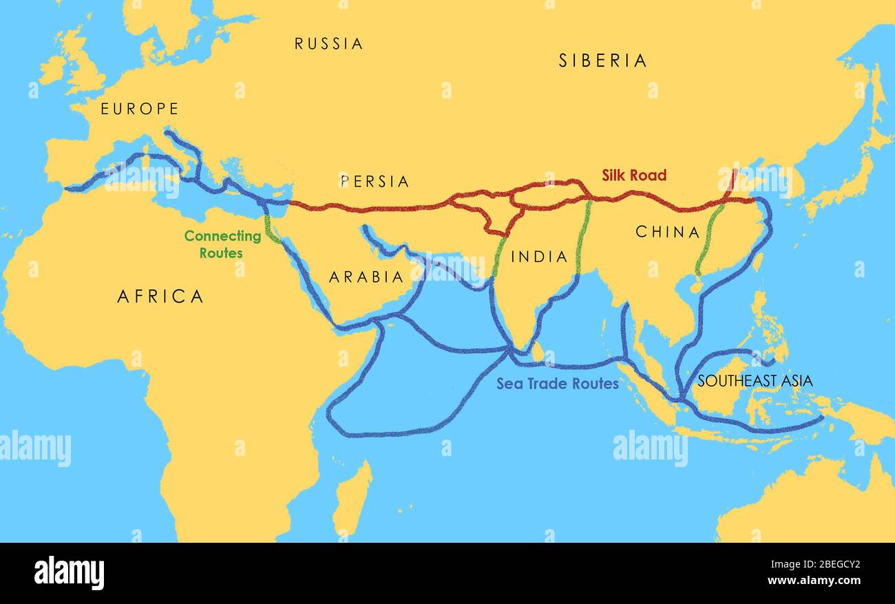
A map showing a network of medieval trade routes, including the Silk Road (connecting East and West between the 2nd century BCE and the 18th century) and various sea trade routes. Image details File size:
14.3 MB (304.3 KB Compressed download)
Open your image file to the full size using image processing software.
Dimensions:
2868 x 1740 px | 24.3 x 14.7 cm | 9.6 x 5.8 inches | 300dpi
Date taken:
14 August 2002
More information:
This image could have imperfections as it’s either historical or reportage.
Search stock photos by tags
Similar stock images A map showing a network of medieval trade routes, including the Silk Road (connecting East and West between the 2nd century BCE and the 18th century) and various sea trade routes. Stock Photo https://www.alamy.com/image-license-details/?v=1 https://www.alamy.com/a-map-showing-a-network-of-medieval-trade-routes-including-the-silk-road-connecting-east-and-west-between-the-2nd-century-bce-and-the-18th-century-and-various-sea-trade-routes-image352776134.html RM 2BDX9FJ – A map showing a network of medieval trade routes, including the Silk Road (connecting East and West between the 2nd century BCE and the 18th century) and various sea trade routes. A map showing a network of medieval trade routes, including the Silk Road (connecting East and West between the 2nd century BCE and the 18th century) and various sea trade routes. The areas in darker yellow indicate the extent of the Islamic world in 1500. Stock Photo https://www.alamy.com/image-license-details/?v=1 https://www.alamy.com/a-map-showing-a-network-of-medieval-trade-routes-including-the-silk-road-connecting-east-and-west-between-the-2nd-century-bce-and-the-18th-century-and-various-sea-trade-routes-the-areas-in-darker-yellow-indicate-the-extent-of-the-islamic-world-in-1500-image353173876.html RM 2BEGCTM – A map showing a network of medieval trade routes, including the Silk Road (connecting East and West between the 2nd century BCE and the 18th century) and various sea trade routes. The areas in darker yellow indicate the extent of the Islamic world in 1500. A map showing a network of medieval trade routes, including the Silk Road (connecting East and West between the 2nd century BCE and the 18th century) and various sea trade routes. The areas in darker yellow indicate the extent of the Islamic world in 1500. Stock Photo https://www.alamy.com/image-license-details/?v=1 https://www.alamy.com/a-map-showing-a-network-of-medieval-trade-routes-including-the-silk-road-connecting-east-and-west-between-the-2nd-century-bce-and-the-18th-century-and-various-sea-trade-routes-the-areas-in-darker-yellow-indicate-the-extent-of-the-islamic-world-in-1500-image352776147.html RM 2BDX9G3 – A map showing a network of medieval trade routes, including the Silk Road (connecting East and West between the 2nd century BCE and the 18th century) and various sea trade routes. The areas in darker yellow indicate the extent of the Islamic world in 1500. A map showing a network of medieval sea trade routes the Mediterranean, the Indian Ocean, Southeast Asia, and the China Sea. Stock Photo https://www.alamy.com/image-license-details/?v=1 https://www.alamy.com/a-map-showing-a-network-of-medieval-sea-trade-routes-the-mediterranean-the-indian-ocean-southeast-asia-and-the-china-sea-image352776148.html RM 2BDX9G4 – A map showing a network of medieval sea trade routes the Mediterranean, the Indian Ocean, Southeast Asia, and the China Sea. A map showing a network of medieval sea trade routes the Mediterranean, the Indian Ocean, Southeast Asia, and the China Sea. Stock Photo https://www.alamy.com/image-license-details/?v=1 https://www.alamy.com/a-map-showing-a-network-of-medieval-sea-trade-routes-the-mediterranean-the-indian-ocean-southeast-asia-and-the-china-sea-image353173822.html RM 2BEGCPP – A map showing a network of medieval sea trade routes the Mediterranean, the Indian Ocean, Southeast Asia, and the China Sea. A map showing a network of medieval sea trade routes. The areas in darker yellow indicate the extent of the Islamic world in 1500. Stock Photo https://www.alamy.com/image-license-details/?v=1 https://www.alamy.com/a-map-showing-a-network-of-medieval-sea-trade-routes-the-areas-in-darker-yellow-indicate-the-extent-of-the-islamic-world-in-1500-image352776150.html RM 2BDX9G6 – A map showing a network of medieval sea trade routes. The areas in darker yellow indicate the extent of the Islamic world in 1500. A map showing a network of medieval sea trade routes. The areas in darker yellow indicate the extent of the Islamic world in 1500. Stock Photo https://www.alamy.com/image-license-details/?v=1 https://www.alamy.com/a-map-showing-a-network-of-medieval-sea-trade-routes-the-areas-in-darker-yellow-indicate-the-extent-of-the-islamic-world-in-1500-image353173917.html RM 2BEGCX5 – A map showing a network of medieval sea trade routes. The areas in darker yellow indicate the extent of the Islamic world in 1500. Map showing the spread of the Black Death in the 14th century from Asia to the Middle East, Western Europe, and North Africa. The bubonic plague was one of the most devastating pandemics in human history, resulting in the deaths of an estimated 75 to 200 million people in Eurasia in the 14th century. The bacterium Yersinia pestis, which results in several forms of plague, is thought to have been the cause. It moved along the Silk Road (a network of trade routes) and by ship and is believed to have been carried and spread by rat fleas living on black rats. Stock Photo https://www.alamy.com/image-license-details/?v=1 https://www.alamy.com/map-showing-the-spread-of-the-black-death-in-the-14th-century-from-asia-to-the-middle-east-western-europe-and-north-africa-the-bubonic-plague-was-one-of-the-most-devastating-pandemics-in-human-history-resulting-in-the-deaths-of-an-estimated-75-to-200-million-people-in-eurasia-in-the-14th-century-the-bacterium-yersinia-pestis-which-results-in-several-forms-of-plague-is-thought-to-have-been-the-cause-it-moved-along-the-silk-road-a-network-of-trade-routes-and-by-ship-and-is-believed-to-have-been-carried-and-spread-by-rat-fleas-living-on-black-rats-image246613674.html RM T96676 – Map showing the spread of the Black Death in the 14th century from Asia to the Middle East, Western Europe, and North Africa. The bubonic plague was one of the most devastating pandemics in human history, resulting in the deaths of an estimated 75 to 200 million people in Eurasia in the 14th century. The bacterium Yersinia pestis, which results in several forms of plague, is thought to have been the cause. It moved along the Silk Road (a network of trade routes) and by ship and is believed to have been carried and spread by rat fleas living on black rats. 