···
A New Map of the Province of Lower Canada. A New Map OF THE PROVINCE OF LOWER CANADA, Describing all the Seigneuries, Townships, Grants of Land, &c. Compiled from Plans deposited in the PATENT OFFICE QUEBEC... London : Published by WILLM. FADEN. Geographer to His Majesty . and to His Royal Highness the Prince of Wales. No.5, Charing Cross, August 12th. 1802. Steelplate engraving with original hand colour. Source: Maps K.Top.119.20. Language: English. Image details File size:
95.1 MB (2.9 MB Compressed download)
Open your image file to the full size using image processing software.
Dimensions:
6875 x 4836 px | 58.2 x 40.9 cm | 22.9 x 16.1 inches | 300dpi
More information:
This image could have imperfections as it’s either historical or reportage.
Search stock photos by tags
Similar stock images A New Map OF THE PROVINCE OF LOWER CANADA, Describing all the Seigneuries, Townships, Grants of Land, &c. Compiled from Plans deposited in the PATENT OFFICE QUEBEC Author Holland, Samuel 119.20. Place of publication: London Publisher: Published by WILLM. FADEN. Geographer to His Majesty . and to His Royal Highness the Prince of Wales. No.5, Charing Cross, Date of publication: August 12th. 1802. Item type: 1 map Medium: steelplate engraving with original hand colour Dimensions: 59 x 87 cm Former owner: George III, King of Great Britain, 1738-1820 Stock Photo https://www.alamy.com/licenses-and-pricing/?v=1 https://www.alamy.com/a-new-map-of-the-province-of-lower-canada-describing-all-the-seigneuries-townships-grants-of-land-c-compiled-from-plans-deposited-in-the-patent-office-quebec-author-holland-samuel-11920-place-of-publication-london-publisher-published-by-willm-faden-geographer-to-his-majesty-and-to-his-royal-highness-the-prince-of-wales-no5-charing-cross-date-of-publication-august-12th-1802-item-type-1-map-medium-steelplate-engraving-with-original-hand-colour-dimensions-59-x-87-cm-former-owner-george-iii-king-of-great-britain-1738-1820-image401733733.html RM 2E9GFD9 – A New Map OF THE PROVINCE OF LOWER CANADA, Describing all the Seigneuries, Townships, Grants of Land, &c. Compiled from Plans deposited in the PATENT OFFICE QUEBEC Author Holland, Samuel 119.20. Place of publication: London Publisher: Published by WILLM. FADEN. Geographer to His Majesty . and to His Royal Highness the Prince of Wales. No.5, Charing Cross, Date of publication: August 12th. 1802. Item type: 1 map Medium: steelplate engraving with original hand colour Dimensions: 59 x 87 cm Former owner: George III, King of Great Britain, 1738-1820 . English: An excellent first edition example of Colton's rare map of Quebec and New Brunswick. Covers what at the time was called Lower or East Canada from Montreal in the southwest to the mouth of the St. Lawrence River in the northwest. Includes the province of New Brunswick. Throughout the map Colton identifies various cities, towns, forts, rivers, rapids, fords, and an assortment of additional topographical details. Map is hand colored in pink, green, yellow and blue pastels to define national and regional boundaries. Surrounded by Colton's typical spiral motif border. Dated and copyrigh Stock Photo https://www.alamy.com/licenses-and-pricing/?v=1 https://www.alamy.com/english-an-excellent-first-edition-example-of-coltons-rare-map-of-quebec-and-new-brunswick-covers-what-at-the-time-was-called-lower-or-east-canada-from-montreal-in-the-southwest-to-the-mouth-of-the-st-lawrence-river-in-the-northwest-includes-the-province-of-new-brunswick-throughout-the-map-colton-identifies-various-cities-towns-forts-rivers-rapids-fords-and-an-assortment-of-additional-topographical-details-map-is-hand-colored-in-pink-green-yellow-and-blue-pastels-to-define-national-and-regional-boundaries-surrounded-by-coltons-typical-spiral-motif-border-dated-and-copyrigh-image184959478.html RM MMWHKJ – . English: An excellent first edition example of Colton's rare map of Quebec and New Brunswick. Covers what at the time was called Lower or East Canada from Montreal in the southwest to the mouth of the St. Lawrence River in the northwest. Includes the province of New Brunswick. Throughout the map Colton identifies various cities, towns, forts, rivers, rapids, fords, and an assortment of additional topographical details. Map is hand colored in pink, green, yellow and blue pastels to define national and regional boundaries. Surrounded by Colton's typical spiral motif border. Dated and copyrigh New Map of the Province of Lower Canada. Stock Photo https://www.alamy.com/licenses-and-pricing/?v=1 https://www.alamy.com/new-map-of-the-province-of-lower-canada-image402253076.html RM 2EAC5W8 – New Map of the Province of Lower Canada. A new Topographical Map of the Province of Lower Canada. London, 1803. Source: Maps K.Top.119.21.1.2.TAB. Language: English. Stock Photo https://www.alamy.com/licenses-and-pricing/?v=1 https://www.alamy.com/a-new-topographical-map-of-the-province-of-lower-canada-london-1803-source-maps-ktop1192112tab-language-english-image226945255.html RM R566YK – A new Topographical Map of the Province of Lower Canada. London, 1803. Source: Maps K.Top.119.21.1.2.TAB. Language: English. A New Topographical Map of the Province of LOWER CANADA, compiled from all the former as well as the Latest Surveys taken by Order of the Provincial Government Author Vondenvelden, William 119.21.1.2 tab. Place of publication: London Publisher: Published by Willm. Vondenvelden No. 20 Cannon Street, Date of publication: Jany 1st 1803. Item type: 1 map on 3 sheets Medium: joined and laid on linen, a copperplate engraving with original hand colour Dimensions: 60 x 217 cm Former owner: George III, King of Great Britain, 1738-1820 Stock Photo https://www.alamy.com/licenses-and-pricing/?v=1 https://www.alamy.com/a-new-topographical-map-of-the-province-of-lower-canada-compiled-from-all-the-former-as-well-as-the-latest-surveys-taken-by-order-of-the-provincial-government-author-vondenvelden-william-1192112-tab-place-of-publication-london-publisher-published-by-willm-vondenvelden-no-20-cannon-street-date-of-publication-jany-1st-1803-item-type-1-map-on-3-sheets-medium-joined-and-laid-on-linen-a-copperplate-engraving-with-original-hand-colour-dimensions-60-x-217-cm-former-owner-george-iii-king-of-great-britain-1738-1820-image401733741.html RM 2E9GFDH – A New Topographical Map of the Province of LOWER CANADA, compiled from all the former as well as the Latest Surveys taken by Order of the Provincial Government Author Vondenvelden, William 119.21.1.2 tab. Place of publication: London Publisher: Published by Willm. Vondenvelden No. 20 Cannon Street, Date of publication: Jany 1st 1803. Item type: 1 map on 3 sheets Medium: joined and laid on linen, a copperplate engraving with original hand colour Dimensions: 60 x 217 cm Former owner: George III, King of Great Britain, 1738-1820 . English: This is the uncommon 1857 issue of J. H. Colton’s map of Quebec and New Brunswick. At the time this region was referred to as Canada East or Lower Canada. Covers lower Canada from Tadoussac in the North to the borders of Maine and Vermont in the south, and from Huntingdon in the west to Westmoreland in the east. Includes a detailed inset of the vicinity of Montreal. Divided and color coded according to province and country. Shows major roadways and railroads as well as geological features such as lakes and rivers. Like most Colton maps this map is dated 1855, but most likely was is Stock Photo https://www.alamy.com/licenses-and-pricing/?v=1 https://www.alamy.com/english-this-is-the-uncommon-1857-issue-of-j-h-coltons-map-of-quebec-and-new-brunswick-at-the-time-this-region-was-referred-to-as-canada-east-or-lower-canada-covers-lower-canada-from-tadoussac-in-the-north-to-the-borders-of-maine-and-vermont-in-the-south-and-from-huntingdon-in-the-west-to-westmoreland-in-the-east-includes-a-detailed-inset-of-the-vicinity-of-montreal-divided-and-color-coded-according-to-province-and-country-shows-major-roadways-and-railroads-as-well-as-geological-features-such-as-lakes-and-rivers-like-most-colton-maps-this-map-is-dated-1855-but-most-likely-was-is-image184961809.html RM MMWMJW – . English: This is the uncommon 1857 issue of J. H. Colton’s map of Quebec and New Brunswick. At the time this region was referred to as Canada East or Lower Canada. Covers lower Canada from Tadoussac in the North to the borders of Maine and Vermont in the south, and from Huntingdon in the west to Westmoreland in the east. Includes a detailed inset of the vicinity of Montreal. Divided and color coded according to province and country. Shows major roadways and railroads as well as geological features such as lakes and rivers. Like most Colton maps this map is dated 1855, but most likely was is Map of the townships of Hamilton & Cox, Bay of Chaleurs, District of Caspé, Lower Canada , Real property, Québec Province, Bonaventure, Maps, Real property, Québec Province, New Carlisle, Maps, Bonaventure Québec, Maps, New Carlisle Québec, Maps Norman B. Leventhal Map Center Collection Stock Photo https://www.alamy.com/licenses-and-pricing/?v=1 https://www.alamy.com/map-of-the-townships-of-hamilton-cox-bay-of-chaleurs-district-of-caspe-lower-canada-real-property-quebec-province-bonaventure-maps-real-property-quebec-province-new-carlisle-maps-bonaventure-quebec-maps-new-carlisle-quebec-maps-norman-b-leventhal-map-center-collection-image501284228.html RM 2M3FD44 – Map of the townships of Hamilton & Cox, Bay of Chaleurs, District of Caspé, Lower Canada , Real property, Québec Province, Bonaventure, Maps, Real property, Québec Province, New Carlisle, Maps, Bonaventure Québec, Maps, New Carlisle Québec, Maps Norman B. Leventhal Map Center Collection 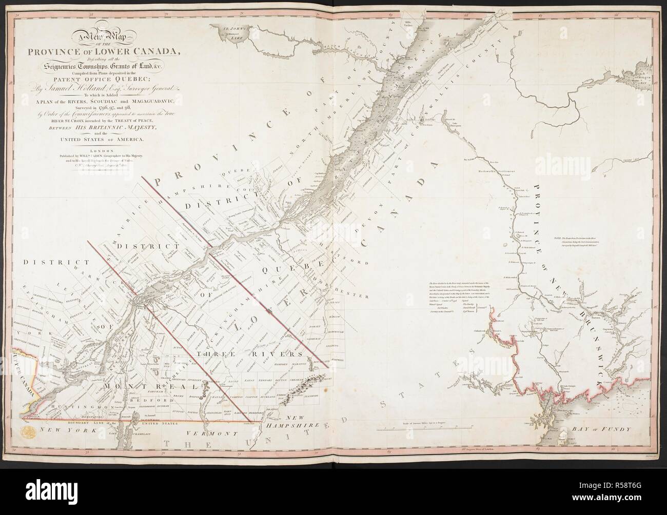