···
Kansas state map with counties borders and colored congressional districts boundaries due to The 2020 United States census and which is valid since 20 Image details Contributor:
brichuas / Alamy Stock Vector
Date created:
14 July 2024
More information:
Kansas state map with counties borders and colored congressional districts boundaries due to The 2020 United States census and which is valid since 2023. Flag of Kansas. Vector
Search stock photos by tags
Similar stock vectors Kansas maps vector outline counties, townships, regions, municipalities, departments, borders Stock Vector https://www.alamy.com/image-license-details/?v=1 https://www.alamy.com/kansas-maps-vector-outline-counties-townships-regions-municipalities-departments-borders-image358303122.html RF 2BPX382 – Kansas maps vector outline counties, townships, regions, municipalities, departments, borders Kansas state outline administrative and political vector map in color Stock Vector https://www.alamy.com/image-license-details/?v=1 https://www.alamy.com/kansas-state-outline-administrative-and-political-vector-map-in-color-image356316953.html RF 2BKKHWD – Kansas state outline administrative and political vector map in color Missouri state map with counties borders and colored congressional districts boundaries due to The 2020 United States census and which is valid since Stock Vector https://www.alamy.com/image-license-details/?v=1 https://www.alamy.com/missouri-state-map-with-counties-borders-and-colored-congressional-districts-boundaries-due-to-the-2020-united-states-census-and-which-is-valid-since-image615026514.html RF 2XMGTGJ – Missouri state map with counties borders and colored congressional districts boundaries due to The 2020 United States census and which is valid since Kansas USA Map black inverted silhouette Stock Vector https://www.alamy.com/image-license-details/?v=1 https://www.alamy.com/stock-photo-kansas-usa-map-black-inverted-silhouette-133879349.html RF HNPMD9 – Kansas USA Map black inverted silhouette High Quality map of Kansas is a state of United States with borders of the counties Stock Vector https://www.alamy.com/image-license-details/?v=1 https://www.alamy.com/high-quality-map-of-kansas-is-a-state-of-united-states-with-borders-of-the-counties-image243973795.html RF T4WY1R – High Quality map of Kansas is a state of United States with borders of the counties Kansas map with American national flag illustration Stock Vector https://www.alamy.com/image-license-details/?v=1 https://www.alamy.com/stock-photo-kansas-map-with-american-national-flag-illustration-142159424.html RF J77WP8 – Kansas map with American national flag illustration Kansas map. Blank vector map of the Us State with counties. Borders of Kansas for your infographic. Vector illustration. Stock Vector https://www.alamy.com/image-license-details/?v=1 https://www.alamy.com/kansas-map-blank-vector-map-of-the-us-state-with-counties-borders-of-kansas-for-your-infographic-vector-illustration-image592461621.html RF 2WBTXRH – Kansas map. Blank vector map of the Us State with counties. Borders of Kansas for your infographic. Vector illustration. Kansas Missouri city map USA labelled black illustration Stock Vector https://www.alamy.com/image-license-details/?v=1 https://www.alamy.com/kansas-missouri-city-map-usa-labelled-black-illustration-image188705485.html RF MY07NH – Kansas Missouri city map USA labelled black illustration Missouri maps vector outline counties, townships, regions, municipalities, departments, borders Stock Vector https://www.alamy.com/image-license-details/?v=1 https://www.alamy.com/missouri-maps-vector-outline-counties-townships-regions-municipalities-departments-borders-image358301701.html RF 2BPX1D9 – Missouri maps vector outline counties, townships, regions, municipalities, departments, borders Kansas state outline administrative and political vector map in black and white Stock Vector https://www.alamy.com/image-license-details/?v=1 https://www.alamy.com/kansas-state-outline-administrative-and-political-vector-map-in-black-and-white-image356318021.html RF 2BKKK7H – Kansas state outline administrative and political vector map in black and white High Quality map of Kansas is a state of United States of America with borders of the counties Stock Vector https://www.alamy.com/image-license-details/?v=1 https://www.alamy.com/high-quality-map-of-kansas-is-a-state-of-united-states-of-america-with-borders-of-the-counties-image364162970.html RF 2C4D1GA – High Quality map of Kansas is a state of United States of America with borders of the counties 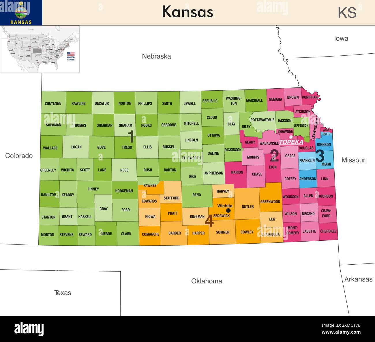