···
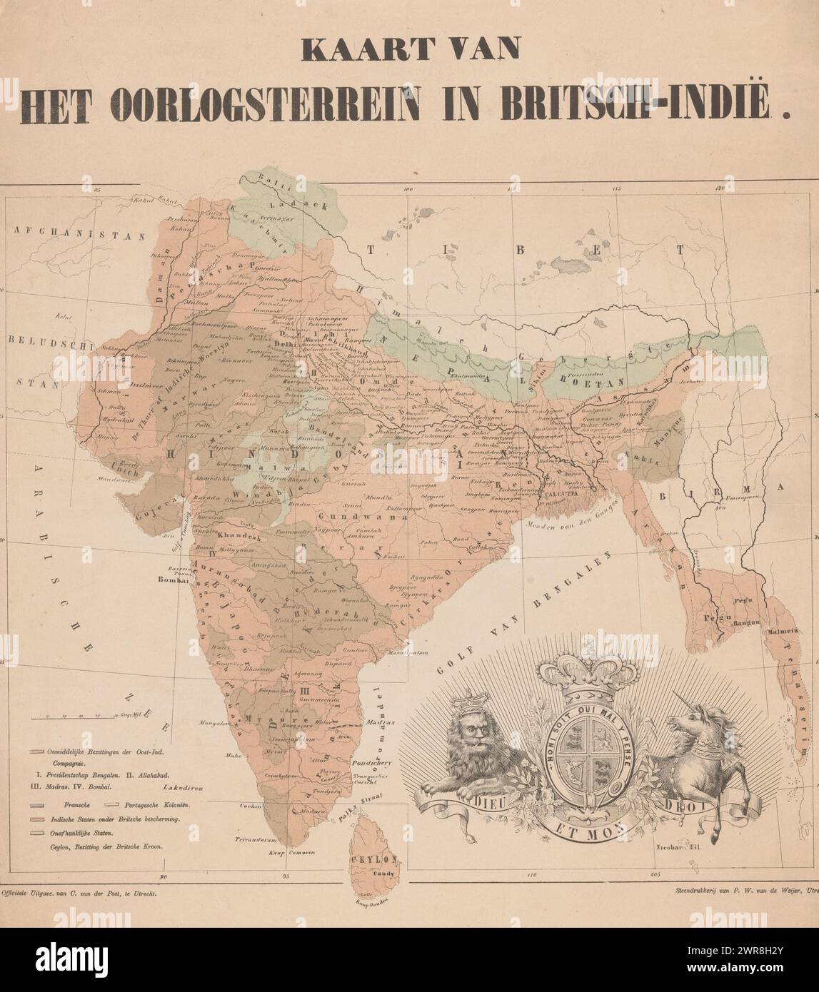
Map of European colonial possessions in India, Map of the war zone in British India (title on object), The coat of arms of the United Kingdom at the bottom of the image., print maker: anonymous, printer: Pieter Wilhelmus van de Weijer, publisher: C. van der Post (II), Utrecht, 1830 - 1879, paper, height 478 mm × width 442 mm, print Image details File size:
74.6 MB (3.4 MB Compressed download)
Open your image file to the full size using image processing software.
Dimensions:
4798 x 5438 px | 40.6 x 46 cm | 16 x 18.1 inches | 300dpi
Date taken:
28 January 2024
More information:
This image could have imperfections as it’s either historical or reportage.
Search stock photos by tags
Similar stock images Map of European colonial possessions in India, Karte vom Kriegsschauplatz in Ostindien (title on object), print maker: anonymous, after drawing by: T. Koenig, printer: C. Kloen, 1850 - 1899, paper, height 385 mm × width 478 mm, print Stock Photo https://www.alamy.com/image-license-details/?v=1 https://www.alamy.com/map-of-european-colonial-possessions-in-india-karte-vom-kriegsschauplatz-in-ostindien-title-on-object-print-maker-anonymous-after-drawing-by-t-koenig-printer-c-kloen-1850-1899-paper-height-385-mm-width-478-mm-print-image599478637.html RM 2WR8H39 – Map of European colonial possessions in India, Karte vom Kriegsschauplatz in Ostindien (title on object), print maker: anonymous, after drawing by: T. Koenig, printer: C. Kloen, 1850 - 1899, paper, height 385 mm × width 478 mm, print United Kingdom: Map of the World, British Imperial possessions coloured in red, 1907. The British Empire comprised the dominions, colonies, protectorates, mandates and other territories ruled or administered by the United Kingdom. It originated with the overseas colonies and trading posts established by England in the late 16th and early 17th centuries. At its height, it was the largest empire in history and, for over a century, was the foremost global power. By 1922 the British Empire held sway over about 458 million people, one-fifth of the world's population at the time. Stock Photo https://www.alamy.com/image-license-details/?v=1 https://www.alamy.com/united-kingdom-map-of-the-world-british-imperial-possessions-coloured-in-red-1907-the-british-empire-comprised-the-dominions-colonies-protectorates-mandates-and-other-territories-ruled-or-administered-by-the-united-kingdom-it-originated-with-the-overseas-colonies-and-trading-posts-established-by-england-in-the-late-16th-and-early-17th-centuries-at-its-height-it-was-the-largest-empire-in-history-and-for-over-a-century-was-the-foremost-global-power-by-1922-the-british-empire-held-sway-over-about-458-million-people-one-fifth-of-the-worlds-population-at-the-time-image344251721.html RM 2B020G9 – United Kingdom: Map of the World, British Imperial possessions coloured in red, 1907. The British Empire comprised the dominions, colonies, protectorates, mandates and other territories ruled or administered by the United Kingdom. It originated with the overseas colonies and trading posts established by England in the late 16th and early 17th centuries. At its height, it was the largest empire in history and, for over a century, was the foremost global power. By 1922 the British Empire held sway over about 458 million people, one-fifth of the world's population at the time. 1884 map - The graphic map of European possessions in Africa by E.G. Ravenstein. : Map showing the following European possessions in Africa: British , French, Portuguese , Spanish , Italian , German , Independent Dutch Africa , African Stock Photo https://www.alamy.com/image-license-details/?v=1 https://www.alamy.com/1884-map-the-graphic-map-of-european-possessions-in-africa-by-eg-ravenstein-map-showing-the-following-european-possessions-in-africa-british-french-portuguese-spanish-italian-german-independent-dutch-africa-african-image615245416.html RM 2XMXRPG – 1884 map - The graphic map of European possessions in Africa by E.G. Ravenstein. : Map showing the following European possessions in Africa: British , French, Portuguese , Spanish , Italian , German , Independent Dutch Africa , African Map of the German Possessions in Africa from the book The story of the great war; the complete historical records of events to date DIPLOMATIC AND STATE PAPERS by Reynolds, Francis Joseph, 1867-1937; Churchill, Allen Leon; Miller, Francis Trevelyan, 1877-1959; Wood, Leonard, 1860-1927; Knight, Austin Melvin, 1854-1927; Palmer, Frederick, 1873-1958; Simonds, Frank Herbert, 1878-; Ruhl, Arthur Brown, 1876- Published 1920 Stock Photo https://www.alamy.com/image-license-details/?v=1 https://www.alamy.com/map-of-the-german-possessions-in-africa-from-the-book-the-story-of-the-great-war-the-complete-historical-records-of-events-to-date-diplomatic-and-state-papers-by-reynolds-francis-joseph-1867-1937-churchill-allen-leon-miller-francis-trevelyan-1877-1959-wood-leonard-1860-1927-knight-austin-melvin-1854-1927-palmer-frederick-1873-1958-simonds-frank-herbert-1878-ruhl-arthur-brown-1876-published-1920-image480021627.html RF 2JTXTDF – Map of the German Possessions in Africa from the book The story of the great war; the complete historical records of events to date DIPLOMATIC AND STATE PAPERS by Reynolds, Francis Joseph, 1867-1937; Churchill, Allen Leon; Miller, Francis Trevelyan, 1877-1959; Wood, Leonard, 1860-1927; Knight, Austin Melvin, 1854-1927; Palmer, Frederick, 1873-1958; Simonds, Frank Herbert, 1878-; Ruhl, Arthur Brown, 1876- Published 1920 Map of European colonial possessions in India, Anonymous, After T. Koenig, 1850 - 1899 print paper maps of separate countries or regions. imperialism India Stock Photo https://www.alamy.com/image-license-details/?v=1 https://www.alamy.com/map-of-european-colonial-possessions-in-india-anonymous-after-t-koenig-1850-1899-print-paper-maps-of-separate-countries-or-regions-imperialism-india-image594175088.html RM 2WEK0AT – Map of European colonial possessions in India, Anonymous, After T. Koenig, 1850 - 1899 print paper maps of separate countries or regions. imperialism India Map of European colonial possessions in India, Anonymous, 1830 - 1879 print At the bottom of the image the weapon of the United Kingdom. paper maps of separate countries or regions. imperialism India Stock Photo https://www.alamy.com/image-license-details/?v=1 https://www.alamy.com/map-of-european-colonial-possessions-in-india-anonymous-1830-1879-print-at-the-bottom-of-the-image-the-weapon-of-the-united-kingdom-paper-maps-of-separate-countries-or-regions-imperialism-india-image594203132.html RM 2WEM84C – Map of European colonial possessions in India, Anonymous, 1830 - 1879 print At the bottom of the image the weapon of the United Kingdom. paper maps of separate countries or regions. imperialism India 