···
France,Caribbean,Lesser Antilles,Guadeloupe,Guadeloupe National Park,aerial view of the Grand Cul-de-Sac Marin (15000 ha),it is delimited in its marine part by the longest coral reef (25 km) terrestrial part by the wider mangrove belt of the Lesser Antilles,here the Caret islet (aerial view) Image details Contributor:
Hemis / Alamy Stock Photo
File size:
49.8 MB (2.9 MB Compressed download)
Open your image file to the full size using image processing software.
Dimensions:
5120 x 3401 px | 43.3 x 28.8 cm | 17.1 x 11.3 inches | 300dpi
Location:
Sainte Rose,Guadeloupe
Search stock photos by tags
Similar stock images France,Caribbean,Lesser Antilles,Guadeloupe,Basse-Terre,Sainte-Rose,aerial view on Cluny beach (aerial view) Stock Photo https://www.alamy.com/licenses-and-pricing/?v=1 https://www.alamy.com/stock-photo-francecaribbeanlesser-antillesguadeloupebasse-terresainte-roseaerial-172595131.html RM M0PARR – France,Caribbean,Lesser Antilles,Guadeloupe,Basse-Terre,Sainte-Rose,aerial view on Cluny beach (aerial view) Guadeloupe sandy beach of Basse-Terre island. Caribbean vacation landscape. Tillet Beach (Plage de Tillet). Stock Photo https://www.alamy.com/licenses-and-pricing/?v=1 https://www.alamy.com/guadeloupe-sandy-beach-of-basse-terre-island-caribbean-vacation-landscape-tillet-beach-plage-de-tillet-image402324449.html RF 2EAFCX9 – Guadeloupe sandy beach of Basse-Terre island. Caribbean vacation landscape. Tillet Beach (Plage de Tillet). Ilet du Gosier - Gosier island - Le Gosier - Guadeloupe Caribbean island Stock Photo https://www.alamy.com/licenses-and-pricing/?v=1 https://www.alamy.com/stock-photo-ilet-du-gosier-gosier-island-le-gosier-guadeloupe-caribbean-island-144391096.html RF JAWG8T – Ilet du Gosier - Gosier island - Le Gosier - Guadeloupe Caribbean island France,Caribbean,Lesser Antilles,Guadeloupe,Basse-Terre,Sainte-Rose,aerial view on Cluny beach (aerial view) Stock Photo https://www.alamy.com/licenses-and-pricing/?v=1 https://www.alamy.com/stock-photo-francecaribbeanlesser-antillesguadeloupebasse-terresainte-roseaerial-172594475.html RM M0PA0B – France,Caribbean,Lesser Antilles,Guadeloupe,Basse-Terre,Sainte-Rose,aerial view on Cluny beach (aerial view) Guadeloupe sandy beach of Basse-Terre island. Caribbean vacation landscape. Grand Bas Vent Beach (Plage du Grand Bas Vent). Stock Photo https://www.alamy.com/licenses-and-pricing/?v=1 https://www.alamy.com/guadeloupe-sandy-beach-of-basse-terre-island-caribbean-vacation-landscape-grand-bas-vent-beach-plage-du-grand-bas-vent-image402324423.html RF 2EAFCWB – Guadeloupe sandy beach of Basse-Terre island. Caribbean vacation landscape. Grand Bas Vent Beach (Plage du Grand Bas Vent). France,Caribbean,Lesser Antilles,Guadeloupe,Grande-Terre,Sainte Anne,aerial view of the municipal beach and its lagoon (aerial view) Stock Photo https://www.alamy.com/licenses-and-pricing/?v=1 https://www.alamy.com/stock-photo-francecaribbeanlesser-antillesguadeloupegrande-terresainte-anneaerial-172595133.html RM M0PARW – France,Caribbean,Lesser Antilles,Guadeloupe,Grande-Terre,Sainte Anne,aerial view of the municipal beach and its lagoon (aerial view) Ilet du Gosier - Gosier island - Le Gosier - Guadeloupe Caribbean island Stock Photo https://www.alamy.com/licenses-and-pricing/?v=1 https://www.alamy.com/stock-photo-ilet-du-gosier-gosier-island-le-gosier-guadeloupe-caribbean-island-144391081.html RF JAWG89 – Ilet du Gosier - Gosier island - Le Gosier - Guadeloupe Caribbean island France,Caribbean,Lesser Antilles,Guadeloupe,Grande-Terre,Le Gosier,aerial view on the beach of Petit Havre (aerial view) Stock Photo https://www.alamy.com/licenses-and-pricing/?v=1 https://www.alamy.com/stock-photo-francecaribbeanlesser-antillesguadeloupegrande-terrele-gosieraerial-172595150.html RM M0PATE – France,Caribbean,Lesser Antilles,Guadeloupe,Grande-Terre,Le Gosier,aerial view on the beach of Petit Havre (aerial view) Conch sea shell souvenir found on Guadeloupe sandy beach of Basse-Terre island. Caribbean vacation landscape. Tillet Beach (Plage de Tillet). Stock Photo https://www.alamy.com/licenses-and-pricing/?v=1 https://www.alamy.com/conch-sea-shell-souvenir-found-on-guadeloupe-sandy-beach-of-basse-terre-island-caribbean-vacation-landscape-tillet-beach-plage-de-tillet-image402324410.html RF 2EAFCTX – Conch sea shell souvenir found on Guadeloupe sandy beach of Basse-Terre island. Caribbean vacation landscape. Tillet Beach (Plage de Tillet). Ilet du Gosier - Gosier island - Le Gosier - Guadeloupe Caribbean island Stock Photo https://www.alamy.com/licenses-and-pricing/?v=1 https://www.alamy.com/stock-photo-ilet-du-gosier-gosier-island-le-gosier-guadeloupe-caribbean-island-144391130.html RF JAWGA2 – Ilet du Gosier - Gosier island - Le Gosier - Guadeloupe Caribbean island France,Caribbean,Lesser Antilles,Guadeloupe,Grande-Terre,Le Gosier,aerial view on the beach of Petit Havre (aerial view) Stock Photo https://www.alamy.com/licenses-and-pricing/?v=1 https://www.alamy.com/stock-photo-francecaribbeanlesser-antillesguadeloupegrande-terrele-gosieraerial-172595153.html RM M0PATH – France,Caribbean,Lesser Antilles,Guadeloupe,Grande-Terre,Le Gosier,aerial view on the beach of Petit Havre (aerial view) Deshaies, Guadeloupe. Typical local town street in the island of Basse-Terre. Stock Photo https://www.alamy.com/licenses-and-pricing/?v=1 https://www.alamy.com/deshaies-guadeloupe-typical-local-town-street-in-the-island-of-basse-terre-image402324128.html RF 2EAFCET – Deshaies, Guadeloupe. Typical local town street in the island of Basse-Terre. Ilet du Gosier - Gosier island - Le Gosier - Guadeloupe Caribbean island Stock Photo https://www.alamy.com/licenses-and-pricing/?v=1 https://www.alamy.com/stock-photo-ilet-du-gosier-gosier-island-le-gosier-guadeloupe-caribbean-island-144519782.html RF JB3CCP – Ilet du Gosier - Gosier island - Le Gosier - Guadeloupe Caribbean island 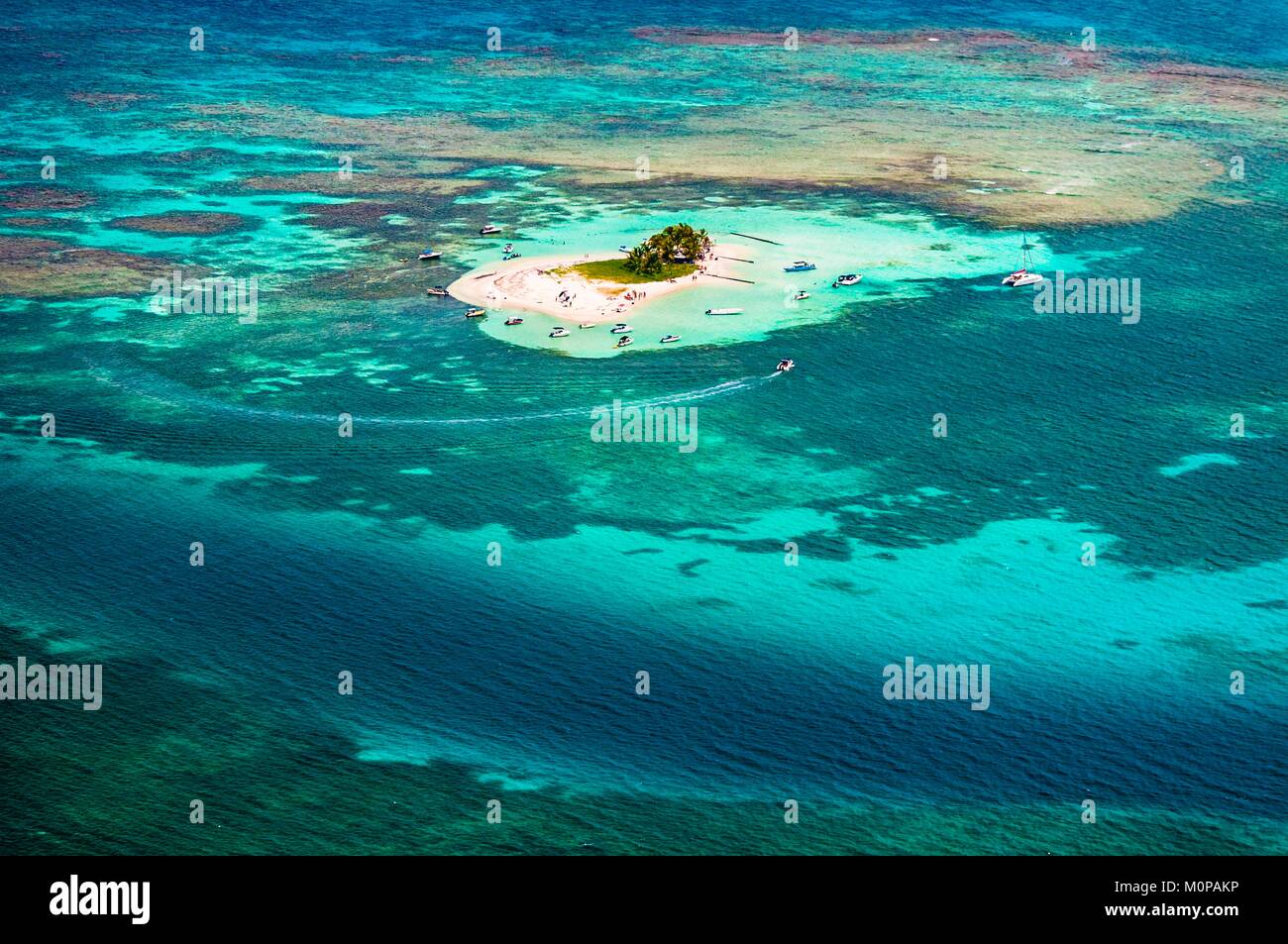