Quick filters:
Africa campaign map Stock Photos and Images
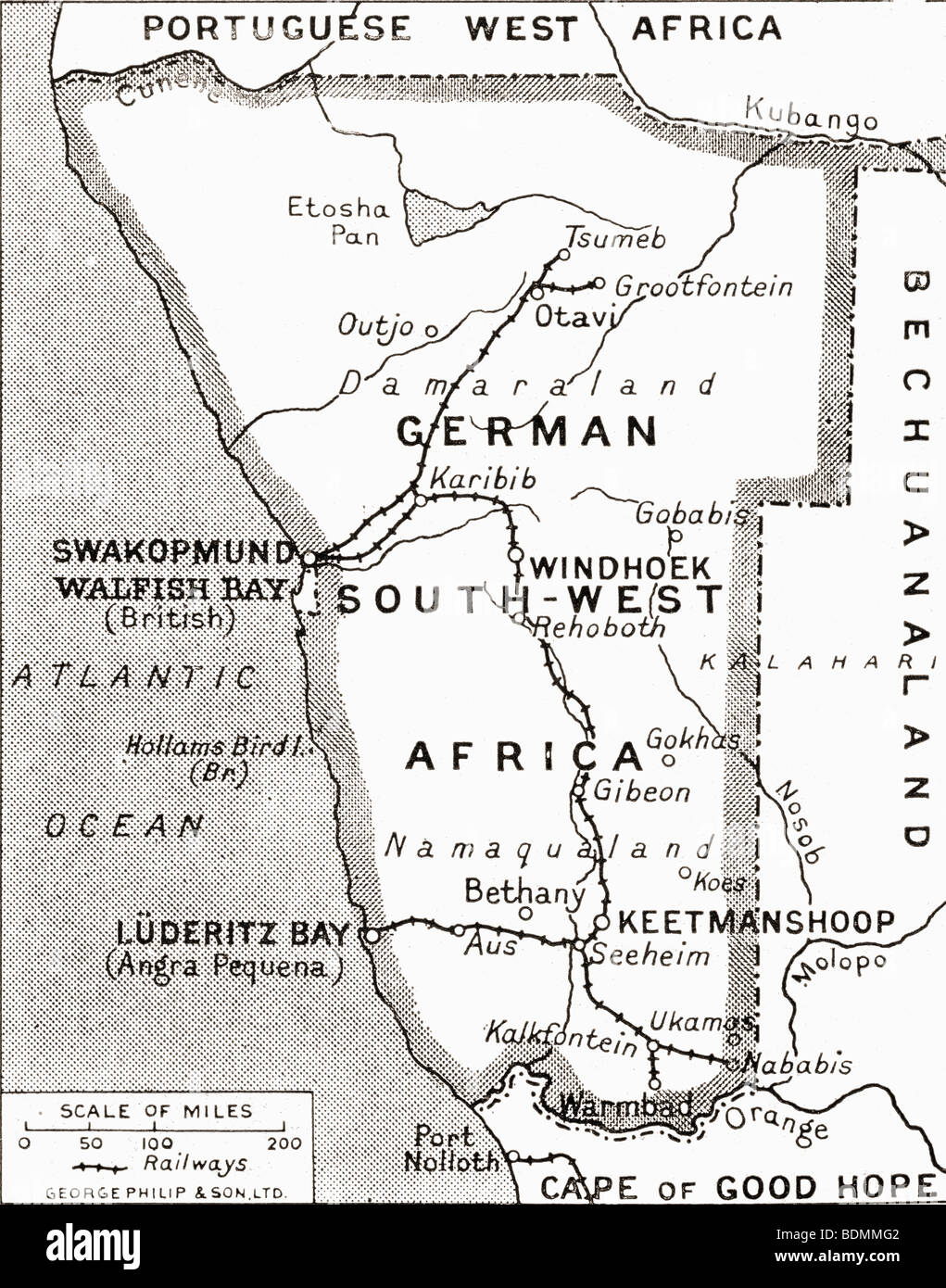 Map of German South West Africa, scene of one of Britain's campaigns, showing Walfish Bay and Keetmanshoop. Stock Photohttps://www.alamy.com/image-license-details/?v=1https://www.alamy.com/stock-photo-map-of-german-south-west-africa-scene-of-one-of-britains-campaigns-25656066.html
RMBDMMG2–Map of German South West Africa, scene of one of Britain's campaigns, showing Walfish Bay and Keetmanshoop.
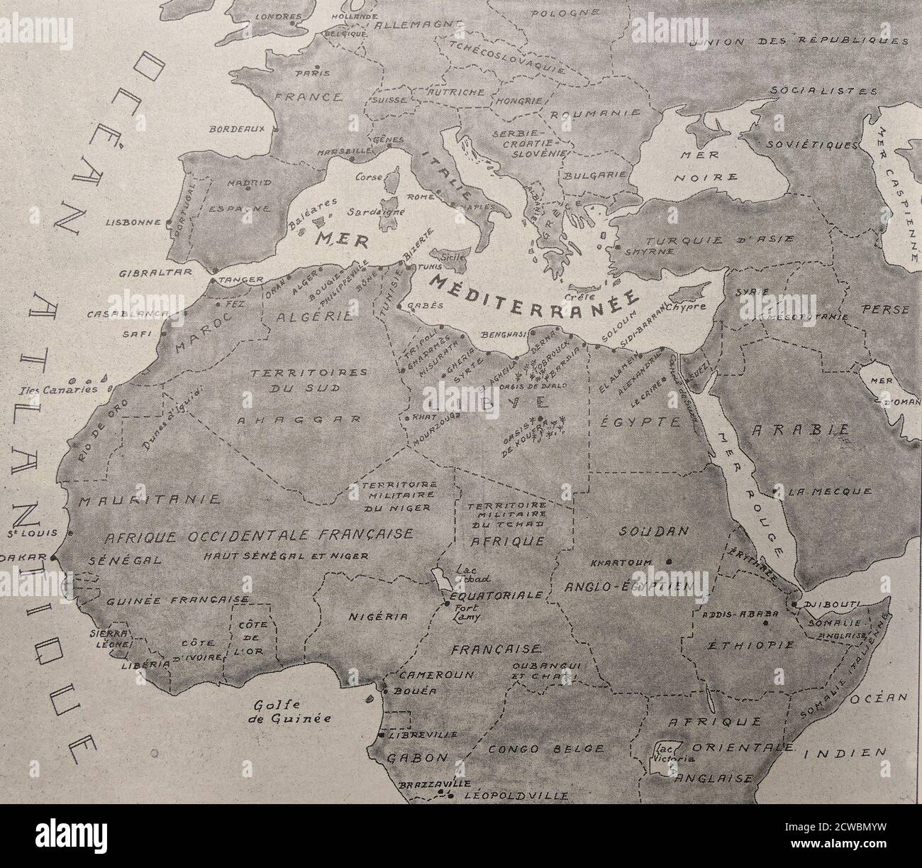 Black and white photograph of World War II (1939-1945); a map of the war in Africa. From the Atlantic Ocean to the Red Seas, from Dakar to Cairo, the African front extends 7,600 km. Stock Photohttps://www.alamy.com/image-license-details/?v=1https://www.alamy.com/black-and-white-photograph-of-world-war-ii-1939-1945-a-map-of-the-war-in-africa-from-the-atlantic-ocean-to-the-red-seas-from-dakar-to-cairo-the-african-front-extends-7600-km-image377042061.html
RM2CWBMYW–Black and white photograph of World War II (1939-1945); a map of the war in Africa. From the Atlantic Ocean to the Red Seas, from Dakar to Cairo, the African front extends 7,600 km.
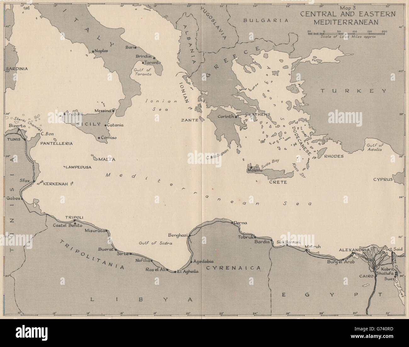 WW2 NORTH AFRICA CAMPAIGN 1941. Central and Eastern Mediterranean, 1956 map Stock Photohttps://www.alamy.com/image-license-details/?v=1https://www.alamy.com/stock-photo-ww2-north-africa-campaign-1941-central-and-eastern-mediterranean-1956-107653265.html
RFG740RD–WW2 NORTH AFRICA CAMPAIGN 1941. Central and Eastern Mediterranean, 1956 map
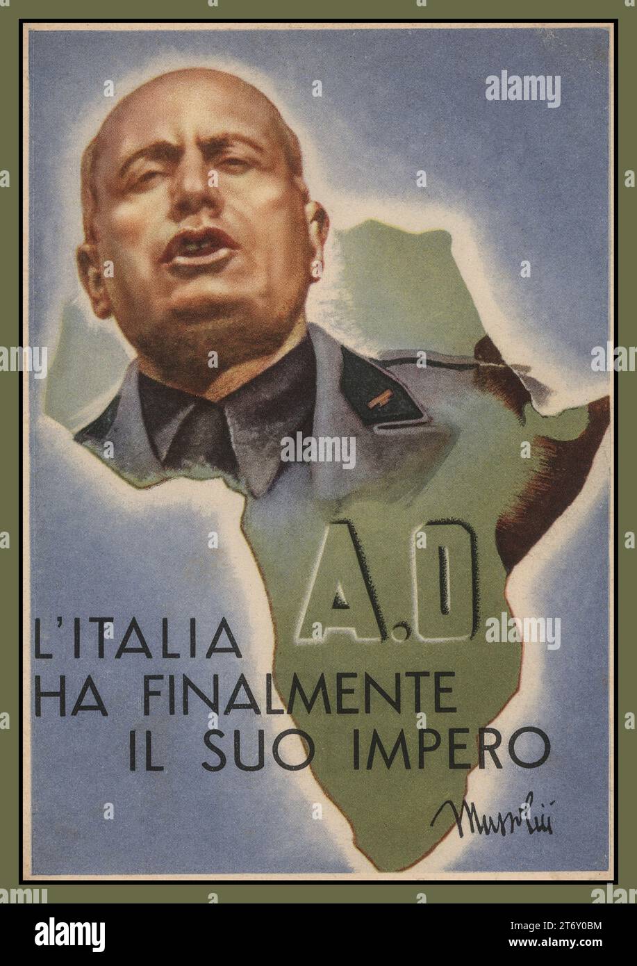 MUSSOLINI Benito Amilcare Andrea Mussolini overlaid on map of Italy, with the caption ' Italy finally has its empire' Vintage Poster Propaganda card. Mussolini was an Italian dictator and journalist who founded and led the National Fascist Party. He led Italy in to World War II and was executed by Italian partisans. Stock Photohttps://www.alamy.com/image-license-details/?v=1https://www.alamy.com/mussolini-benito-amilcare-andrea-mussolini-overlaid-on-map-of-italy-with-the-caption-italy-finally-has-its-empire-vintage-poster-propaganda-card-mussolini-was-an-italian-dictator-and-journalist-who-founded-and-led-the-national-fascist-party-he-led-italy-in-to-world-war-ii-and-was-executed-by-italian-partisans-image572223112.html
RM2T6Y0BM–MUSSOLINI Benito Amilcare Andrea Mussolini overlaid on map of Italy, with the caption ' Italy finally has its empire' Vintage Poster Propaganda card. Mussolini was an Italian dictator and journalist who founded and led the National Fascist Party. He led Italy in to World War II and was executed by Italian partisans.
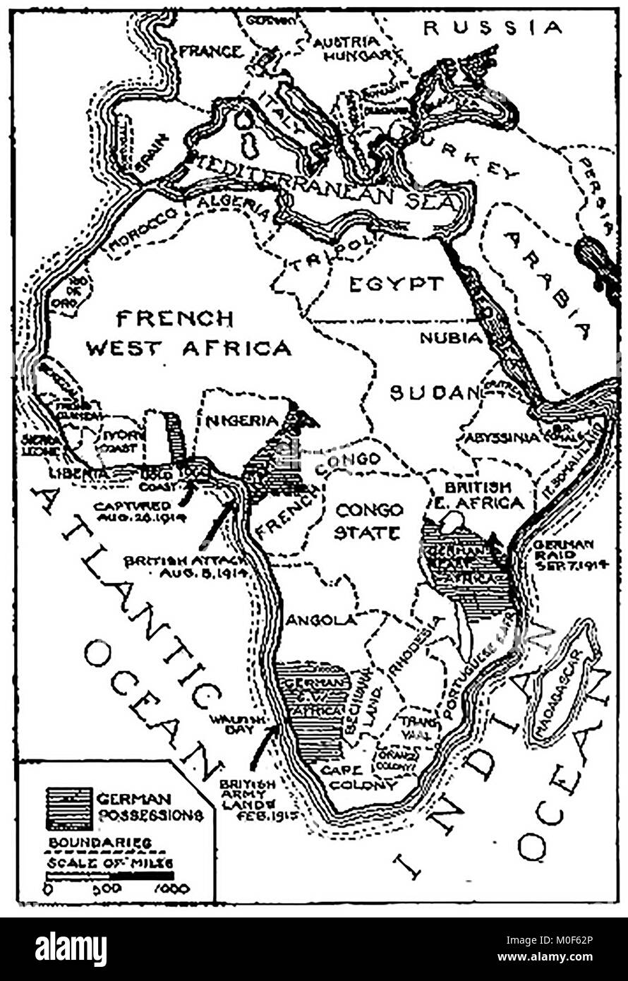 WWI - A 1917 map showing military activity in the 1914-1918 - First World War - The campaign in Togoland & Cameroons and the German possessions in Africa Stock Photohttps://www.alamy.com/image-license-details/?v=1https://www.alamy.com/stock-photo-wwi-a-1917-map-showing-military-activity-in-the-1914-1918-first-world-172437742.html
RMM0F62P–WWI - A 1917 map showing military activity in the 1914-1918 - First World War - The campaign in Togoland & Cameroons and the German possessions in Africa
 Even the children have the war fever . Poring over a large scale map of East Africa at their house in Rome , three small girls keenly discuss the Italian campaign in Abyssinia , tracing the route of the advance in Makale . 9 November 1935 Stock Photohttps://www.alamy.com/image-license-details/?v=1https://www.alamy.com/even-the-children-have-the-war-fever-poring-over-a-large-scale-map-of-east-africa-at-their-house-in-rome-three-small-girls-keenly-discuss-the-italian-campaign-in-abyssinia-tracing-the-route-of-the-advance-in-makale-9-november-1935-image359650174.html
RM2BW3DD2–Even the children have the war fever . Poring over a large scale map of East Africa at their house in Rome , three small girls keenly discuss the Italian campaign in Abyssinia , tracing the route of the advance in Makale . 9 November 1935
 South Africa map on a Rastafarian flag button, white background. Stock Photohttps://www.alamy.com/image-license-details/?v=1https://www.alamy.com/stock-photo-south-africa-map-on-a-rastafarian-flag-button-white-background-114286578.html
RMGHX5KE–South Africa map on a Rastafarian flag button, white background.
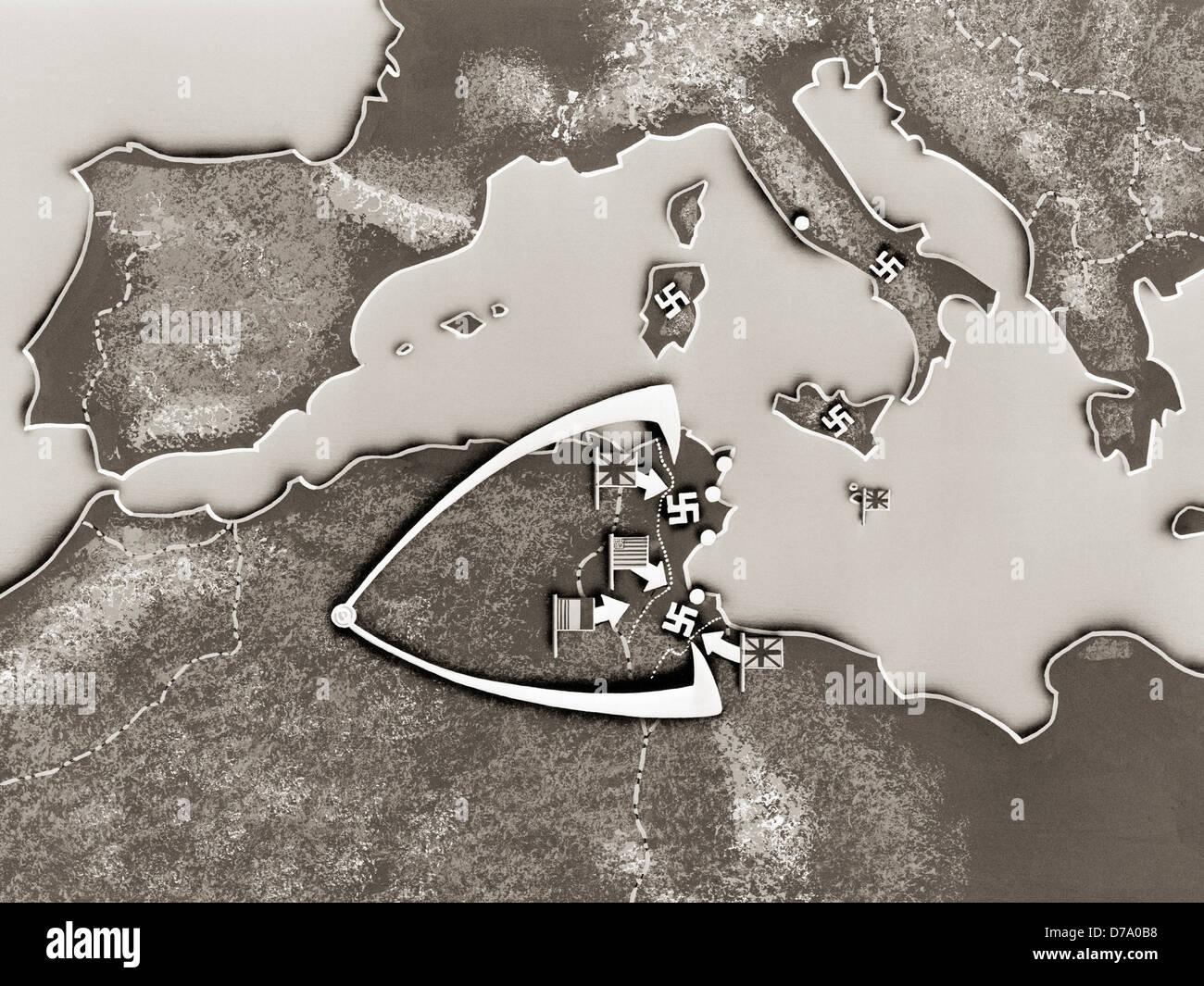 Map Tunisia Campaign Stock Photohttps://www.alamy.com/image-license-details/?v=1https://www.alamy.com/stock-photo-map-tunisia-campaign-56153532.html
RMD7A0B8–Map Tunisia Campaign
 Relief map of Africa. Detail of The Africa Service Medal: South African campaign medal for service during the Second World War, awarded to members of Stock Photohttps://www.alamy.com/image-license-details/?v=1https://www.alamy.com/relief-map-of-africa-detail-of-the-africa-service-medal-south-african-campaign-medal-for-service-during-the-second-world-war-awarded-to-members-of-image213526632.html
RMPBAYB4–Relief map of Africa. Detail of The Africa Service Medal: South African campaign medal for service during the Second World War, awarded to members of
 Continent of Africa flag button Stock Photohttps://www.alamy.com/image-license-details/?v=1https://www.alamy.com/stock-image-continent-of-africa-flag-button-169191514.html
RFKR79E2–Continent of Africa flag button
 City Lights of Africa, Europe, and the Middle East. World global map. Stock Photohttps://www.alamy.com/image-license-details/?v=1https://www.alamy.com/city-lights-of-africa-europe-and-the-middle-east-world-global-map-image600556064.html
RF2WW1KAT–City Lights of Africa, Europe, and the Middle East. World global map.
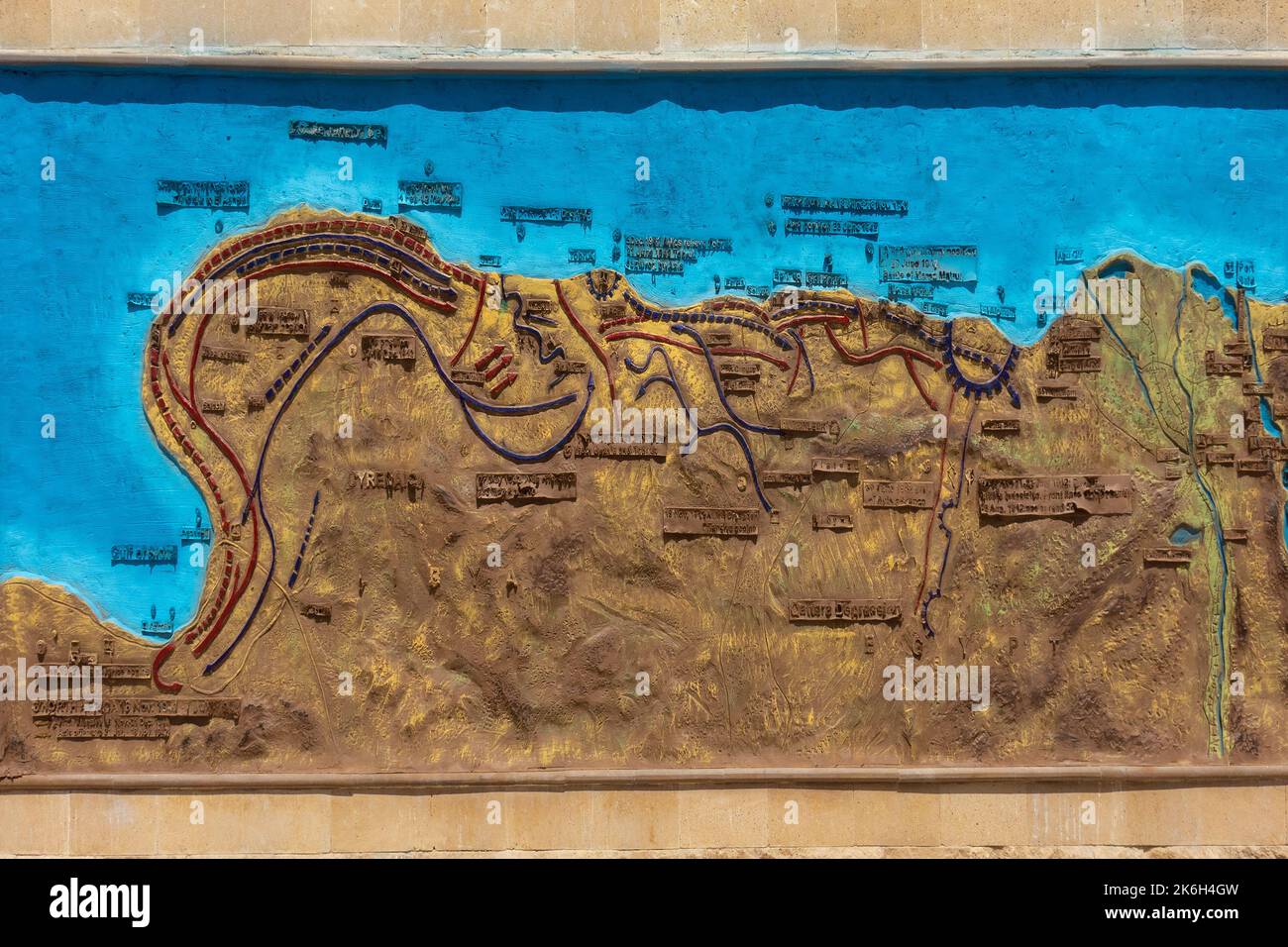 Egypt, El Alamein war memorial, mueum, campaign map mural Stock Photohttps://www.alamy.com/image-license-details/?v=1https://www.alamy.com/egypt-el-alamein-war-memorial-mueum-campaign-map-mural-image485955033.html
RM2K6H4GW–Egypt, El Alamein war memorial, mueum, campaign map mural
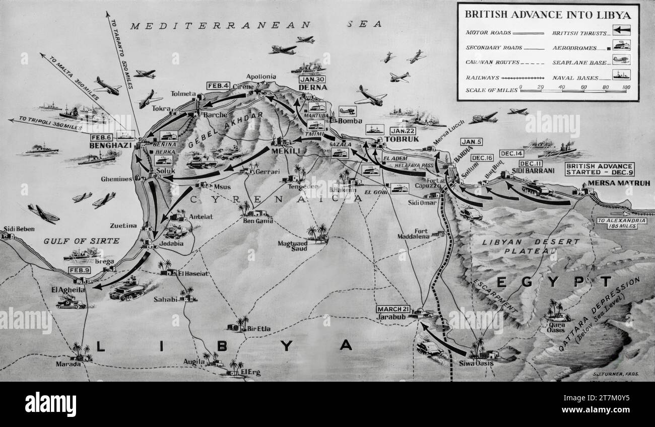 A Second World War map illustrating British advances into Libya that began in December 1940 and culminated in the capture of Benghazi on the 6th February 1941. Stock Photohttps://www.alamy.com/image-license-details/?v=1https://www.alamy.com/a-second-world-war-map-illustrating-british-advances-into-libya-that-began-in-december-1940-and-culminated-in-the-capture-of-benghazi-on-the-6th-february-1941-image572684537.html
RM2T7M0Y5–A Second World War map illustrating British advances into Libya that began in December 1940 and culminated in the capture of Benghazi on the 6th February 1941.
 Chart of Kimberley relief campaign from the book ' Boer and Britisher in South Africa; a history of the Boer-British war and the wars for United South Africa, together with biographies of the great men who made the history of South Africa ' By Neville, John Ormond Published by Thompson & Thomas, Chicago, USA in 1900 Stock Photohttps://www.alamy.com/image-license-details/?v=1https://www.alamy.com/chart-of-kimberley-relief-campaign-from-the-book-boer-and-britisher-in-south-africa-a-history-of-the-boer-british-war-and-the-wars-for-united-south-africa-together-with-biographies-of-the-great-men-who-made-the-history-of-south-africa-by-neville-john-ormond-published-by-thompson-thomas-chicago-usa-in-1900-image413983231.html
RF2F1EFRB–Chart of Kimberley relief campaign from the book ' Boer and Britisher in South Africa; a history of the Boer-British war and the wars for United South Africa, together with biographies of the great men who made the history of South Africa ' By Neville, John Ormond Published by Thompson & Thomas, Chicago, USA in 1900
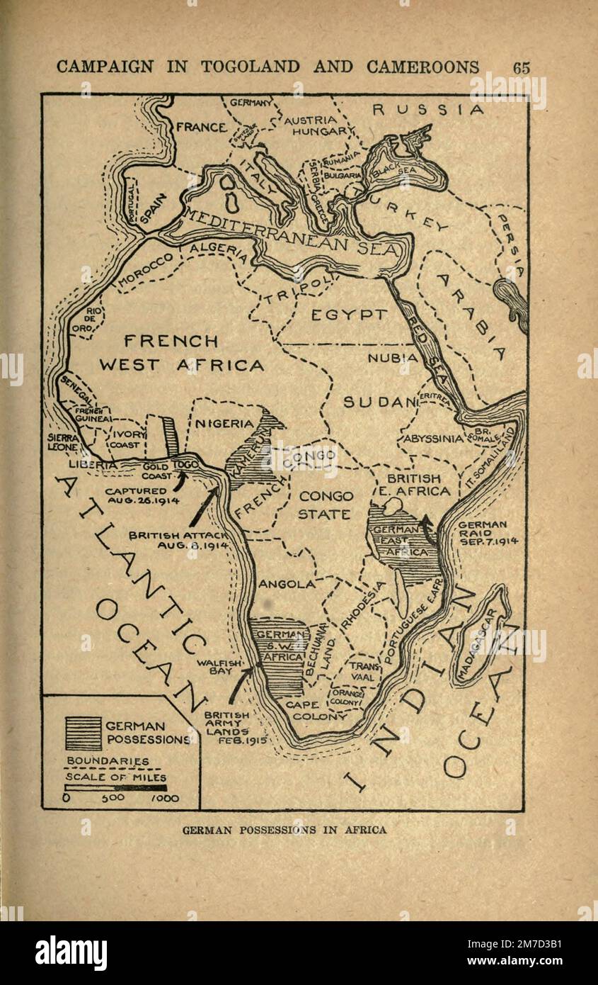 German Possessions in Africa from the book The story of the great war; the complete historical records of events to date DIPLOMATIC AND STATE PAPERS by Reynolds, Francis Joseph, 1867-1937; Churchill, Allen Leon; Miller, Francis Trevelyan, 1877-1959; Wood, Leonard, 1860-1927; Knight, Austin Melvin, 1854-1927; Palmer, Frederick, 1873-1958; Simonds, Frank Herbert, 1878-; Ruhl, Arthur Brown, 1876- Volume III Published 1920 Stock Photohttps://www.alamy.com/image-license-details/?v=1https://www.alamy.com/german-possessions-in-africa-from-the-book-the-story-of-the-great-war-the-complete-historical-records-of-events-to-date-diplomatic-and-state-papers-by-reynolds-francis-joseph-1867-1937-churchill-allen-leon-miller-francis-trevelyan-1877-1959-wood-leonard-1860-1927-knight-austin-melvin-1854-1927-palmer-frederick-1873-1958-simonds-frank-herbert-1878-ruhl-arthur-brown-1876-volume-iii-published-1920-image503691301.html
RF2M7D3B1–German Possessions in Africa from the book The story of the great war; the complete historical records of events to date DIPLOMATIC AND STATE PAPERS by Reynolds, Francis Joseph, 1867-1937; Churchill, Allen Leon; Miller, Francis Trevelyan, 1877-1959; Wood, Leonard, 1860-1927; Knight, Austin Melvin, 1854-1927; Palmer, Frederick, 1873-1958; Simonds, Frank Herbert, 1878-; Ruhl, Arthur Brown, 1876- Volume III Published 1920
 German East African Exhibit, Campaign Double Tent. (Photographs, casts, and map of German East Africa). (Palace of Agriculture). (1904 World's Fair) Stock Photohttps://www.alamy.com/image-license-details/?v=1https://www.alamy.com/stock-image-german-east-african-exhibit-campaign-double-tent-photographs-casts-162736757.html
RMKCN8B1–German East African Exhibit, Campaign Double Tent. (Photographs, casts, and map of German East Africa). (Palace of Agriculture). (1904 World's Fair)
 'Map Illustrating the Campaigns and Marches of Alexander the Great', 1890. Creator: Unknown. Stock Photohttps://www.alamy.com/image-license-details/?v=1https://www.alamy.com/map-illustrating-the-campaigns-and-marches-of-alexander-the-great-1890-creator-unknown-image248907010.html
RMTCXKC2–'Map Illustrating the Campaigns and Marches of Alexander the Great', 1890. Creator: Unknown.
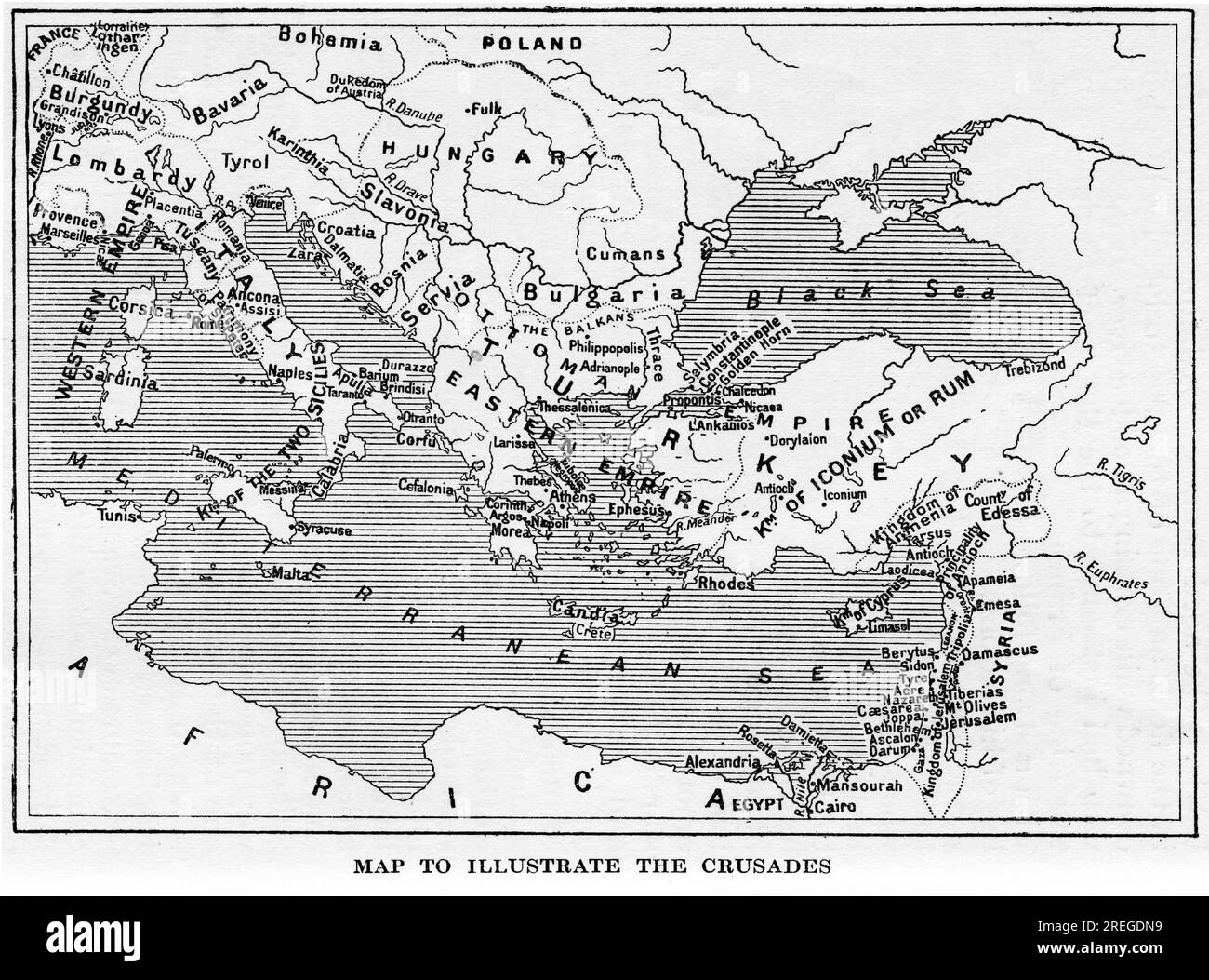 Map to illustrate the crusades, published circa 1880 Stock Photohttps://www.alamy.com/image-license-details/?v=1https://www.alamy.com/map-to-illustrate-the-crusades-published-circa-1880-image559698981.html
RM2REGDN9–Map to illustrate the crusades, published circa 1880
!['Map Illustrating General Buller's Campaign in Natal - May-June 1900', 1901. From "South Africa and the Transvaal War, Vol. VI", by Louis Creswicke. [T. C. & E. C. Jack, Edinburgh, 1901] Stock Photo 'Map Illustrating General Buller's Campaign in Natal - May-June 1900', 1901. From "South Africa and the Transvaal War, Vol. VI", by Louis Creswicke. [T. C. & E. C. Jack, Edinburgh, 1901] Stock Photo](https://c8.alamy.com/comp/2AG0GTF/map-illustrating-general-bullers-campaign-in-natal-may-june-1900-1901-from-quotsouth-africa-and-the-transvaal-war-vol-viquot-by-louis-creswicke-t-c-amp-e-c-jack-edinburgh-1901-2AG0GTF.jpg) 'Map Illustrating General Buller's Campaign in Natal - May-June 1900', 1901. From "South Africa and the Transvaal War, Vol. VI", by Louis Creswicke. [T. C. & E. C. Jack, Edinburgh, 1901] Stock Photohttps://www.alamy.com/image-license-details/?v=1https://www.alamy.com/map-illustrating-general-bullers-campaign-in-natal-may-june-1900-1901-from-quotsouth-africa-and-the-transvaal-war-vol-viquot-by-louis-creswicke-t-c-amp-e-c-jack-edinburgh-1901-image336844719.html
'Map Illustrating General Buller's Campaign in Natal - May-June 1900', 1901. From "South Africa and the Transvaal War, Vol. VI", by Louis Creswicke. [T. C. & E. C. Jack, Edinburgh, 1901] Stock Photohttps://www.alamy.com/image-license-details/?v=1https://www.alamy.com/map-illustrating-general-bullers-campaign-in-natal-may-june-1900-1901-from-quotsouth-africa-and-the-transvaal-war-vol-viquot-by-louis-creswicke-t-c-amp-e-c-jack-edinburgh-1901-image336844719.htmlRM2AG0GTF–'Map Illustrating General Buller's Campaign in Natal - May-June 1900', 1901. From "South Africa and the Transvaal War, Vol. VI", by Louis Creswicke. [T. C. & E. C. Jack, Edinburgh, 1901]
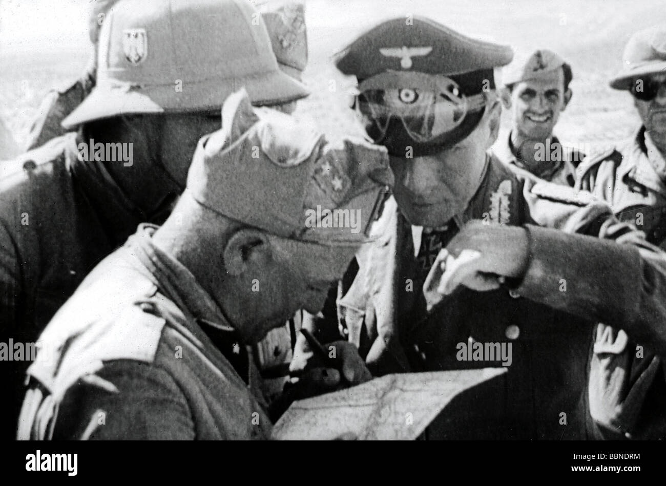 events, Second World War / WWII, North Africa, General Erwin Rommel during a briefing with German and Italian officers, 1941 / 1942, Stock Photohttps://www.alamy.com/image-license-details/?v=1https://www.alamy.com/stock-photo-events-second-world-war-wwii-north-africa-general-erwin-rommel-during-24443432.html
RMBBNDRM–events, Second World War / WWII, North Africa, General Erwin Rommel during a briefing with German and Italian officers, 1941 / 1942,
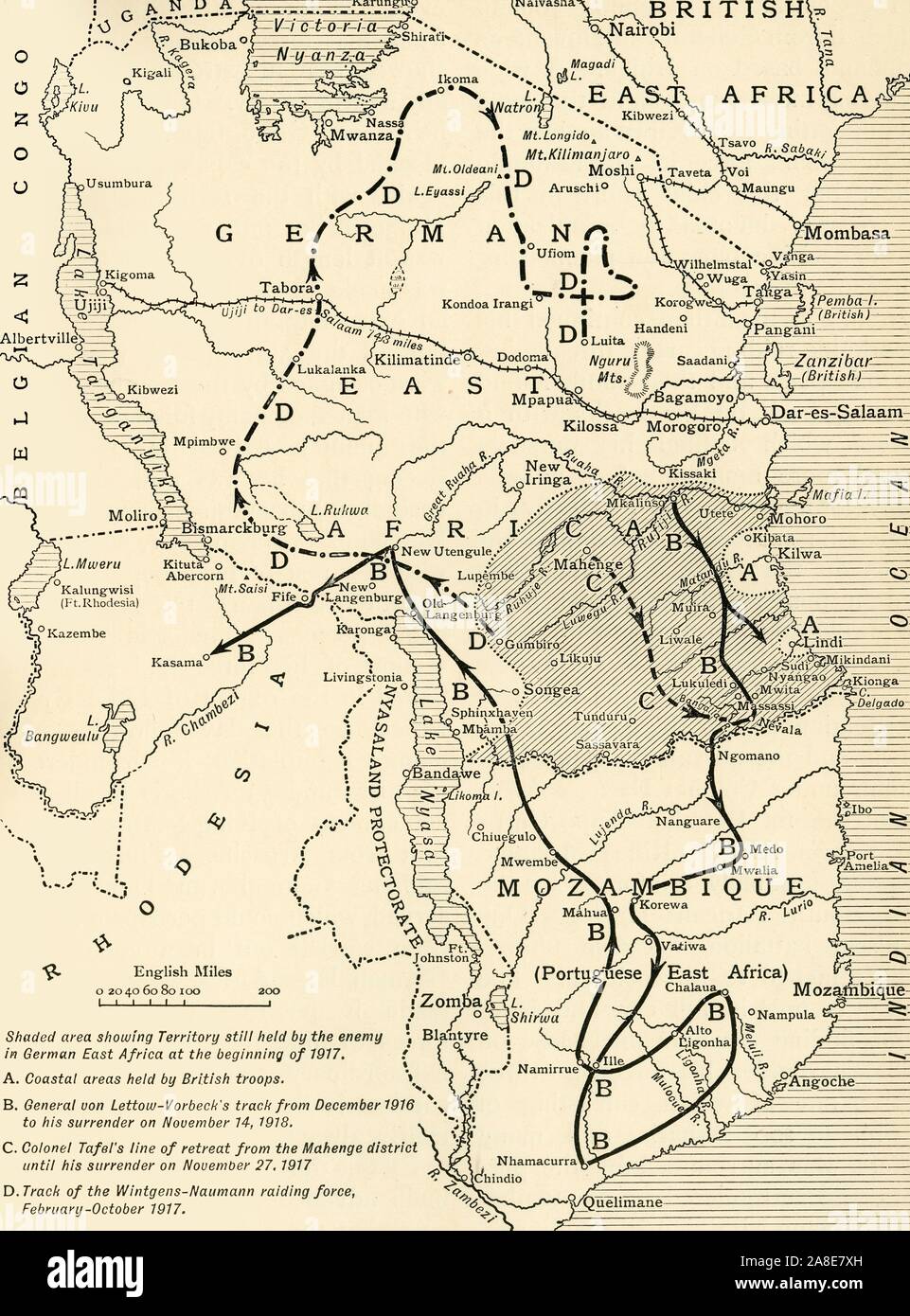 'Map illustrating the Closing Phases of the East African Campaign, 1917-18', (c1920). European powers in Africa during the First World War: 'Shaded area showing Territory still held by the enemy in German East Africa at the beginning of 1917; Coastal areas held by British troops; General von Lettow-Vorbeck's track from December 1916 to his surrender on November 14, 1918; Colonel Tafel's line of retreat from the Mohenge district until his surrender on November 27, 1918; Track of the Wintgens-Naumann raiding force, February-October 1917'. From "The Great World War: A History", Volume I Stock Photohttps://www.alamy.com/image-license-details/?v=1https://www.alamy.com/map-illustrating-the-closing-phases-of-the-east-african-campaign-1917-18-c1920-european-powers-in-africa-during-the-first-world-war-shaded-area-showing-territory-still-held-by-the-enemy-in-german-east-africa-at-the-beginning-of-1917-coastal-areas-held-by-british-troops-general-von-lettow-vorbecks-track-from-december-1916-to-his-surrender-on-november-14-1918-colonel-tafels-line-of-retreat-from-the-mohenge-district-until-his-surrender-on-november-27-1918-track-of-the-wintgens-naumann-raiding-force-february-october-1917-from-quotthe-great-world-war-a-historyquot-volume-i-image332227801.html
RM2A8E7XH–'Map illustrating the Closing Phases of the East African Campaign, 1917-18', (c1920). European powers in Africa during the First World War: 'Shaded area showing Territory still held by the enemy in German East Africa at the beginning of 1917; Coastal areas held by British troops; General von Lettow-Vorbeck's track from December 1916 to his surrender on November 14, 1918; Colonel Tafel's line of retreat from the Mohenge district until his surrender on November 27, 1918; Track of the Wintgens-Naumann raiding force, February-October 1917'. From "The Great World War: A History", Volume I
 NORTH AFRICA CAMPAIGN April 1941. Rommel's advance, Cyrenaica. Libya, 1956 map Stock Photohttps://www.alamy.com/image-license-details/?v=1https://www.alamy.com/stock-photo-north-africa-campaign-april-1941-rommels-advance-cyrenaica-libya-1956-107653377.html
RFG740YD–NORTH AFRICA CAMPAIGN April 1941. Rommel's advance, Cyrenaica. Libya, 1956 map
 708 German East African Exhibit, Campaign Double Tent. (Photographs, casts, and map of German East Africa). (Palace of Agriculture). (1904 World's Fair) Stock Photohttps://www.alamy.com/image-license-details/?v=1https://www.alamy.com/708-german-east-african-exhibit-campaign-double-tent-photographs-casts-and-map-of-german-east-africa-palace-of-agriculture-1904-worlds-fair-image212775032.html
RMPA4MM8–708 German East African Exhibit, Campaign Double Tent. (Photographs, casts, and map of German East Africa). (Palace of Agriculture). (1904 World's Fair)
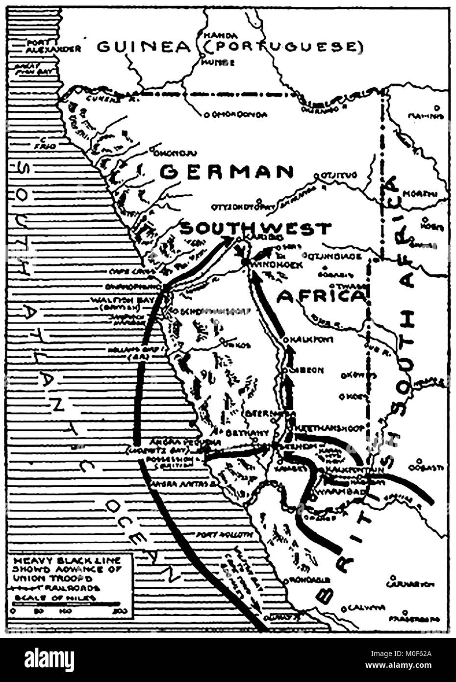 WWI - A 1917 map showing military activity in the 1914-1918 First World War - South West Africa & its conquest by Union Troops under General Botha. East Africa Campaign Stock Photohttps://www.alamy.com/image-license-details/?v=1https://www.alamy.com/stock-photo-wwi-a-1917-map-showing-military-activity-in-the-1914-1918-first-world-172437730.html
RMM0F62A–WWI - A 1917 map showing military activity in the 1914-1918 First World War - South West Africa & its conquest by Union Troops under General Botha. East Africa Campaign
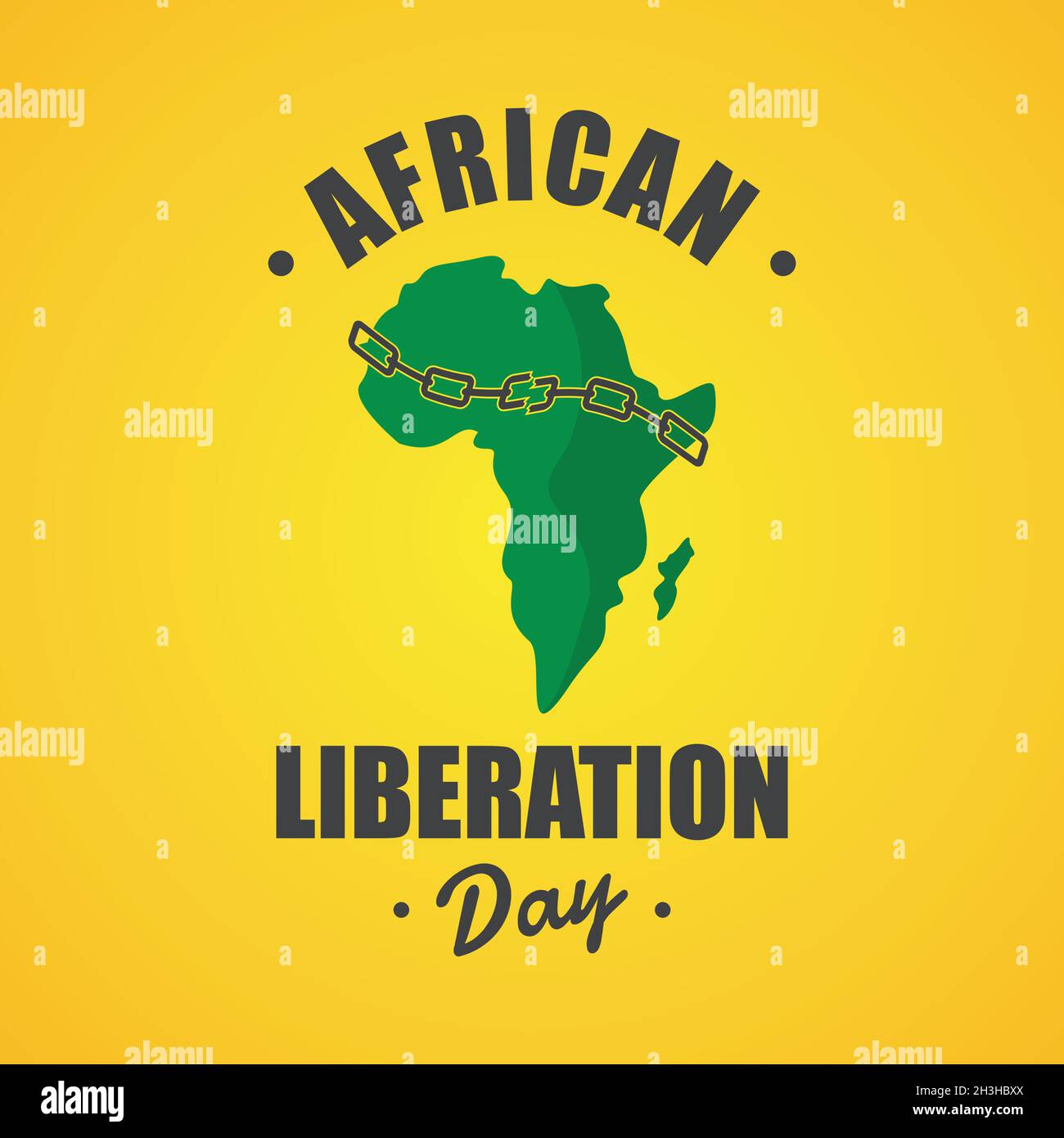 An illustration of African Liberation Day with African map and chain breaking. Vector illustration EPS.8 EPS.10 Stock Vectorhttps://www.alamy.com/image-license-details/?v=1https://www.alamy.com/an-illustration-of-african-liberation-day-with-african-map-and-chain-breaking-vector-illustration-eps8-eps10-image449696098.html
RF2H3HBXX–An illustration of African Liberation Day with African map and chain breaking. Vector illustration EPS.8 EPS.10
 Equatorial Guinea map on a Rastafarian flag button, white background. Stock Photohttps://www.alamy.com/image-license-details/?v=1https://www.alamy.com/stock-photo-equatorial-guinea-map-on-a-rastafarian-flag-button-white-background-114243058.html
RMGHT656–Equatorial Guinea map on a Rastafarian flag button, white background.
 Africa Industrialization Day. Holiday concept. Template for background, banner, card, poster with text inscription. Vector illustration Stock Vectorhttps://www.alamy.com/image-license-details/?v=1https://www.alamy.com/africa-industrialization-day-holiday-concept-template-for-background-banner-card-poster-with-text-inscription-vector-illustration-image569679929.html
RF2T2R4FN–Africa Industrialization Day. Holiday concept. Template for background, banner, card, poster with text inscription. Vector illustration
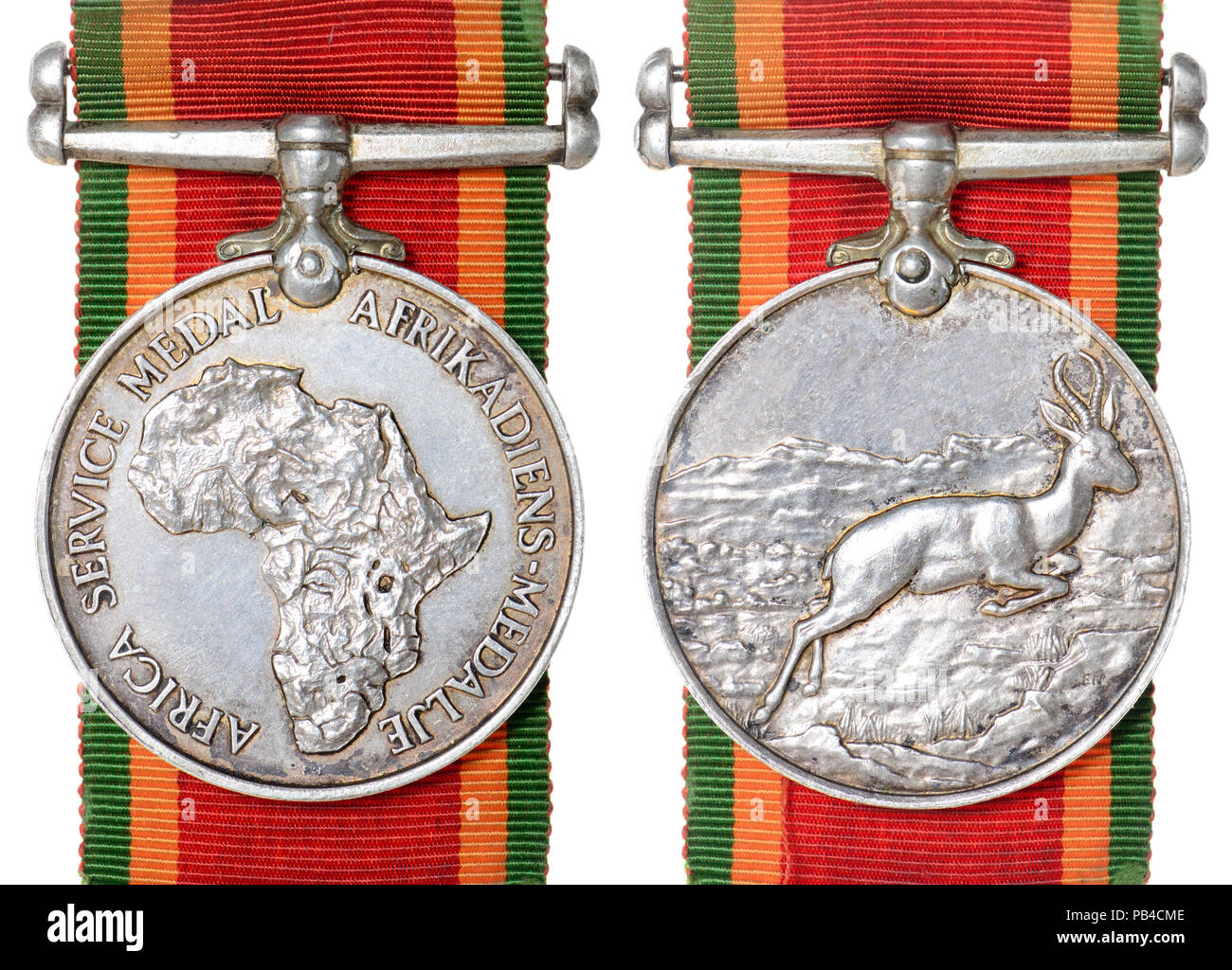 The Africa Service Medal: South African campaign medal for service during the Second World War, awarded to members of the Union Defence Forces, the So Stock Photohttps://www.alamy.com/image-license-details/?v=1https://www.alamy.com/the-africa-service-medal-south-african-campaign-medal-for-service-during-the-second-world-war-awarded-to-members-of-the-union-defence-forces-the-so-image213383422.html
RMPB4CME–The Africa Service Medal: South African campaign medal for service during the Second World War, awarded to members of the Union Defence Forces, the So
 Congo map on a Rastafarian flag button Stock Photohttps://www.alamy.com/image-license-details/?v=1https://www.alamy.com/stock-image-congo-map-on-a-rastafarian-flag-button-169191511.html
RFKR79DY–Congo map on a Rastafarian flag button
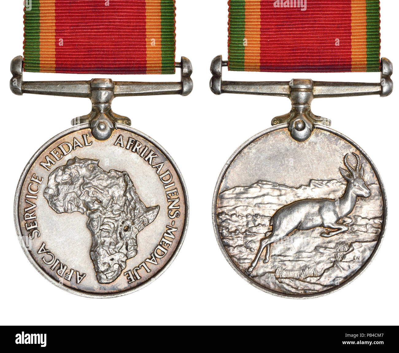 The Africa Service Medal: South African campaign medal for service during the Second World War, awarded to members of the Union Defence Forces, the So Stock Photohttps://www.alamy.com/image-license-details/?v=1https://www.alamy.com/the-africa-service-medal-south-african-campaign-medal-for-service-during-the-second-world-war-awarded-to-members-of-the-union-defence-forces-the-so-image213383415.html
RMPB4CM7–The Africa Service Medal: South African campaign medal for service during the Second World War, awarded to members of the Union Defence Forces, the So
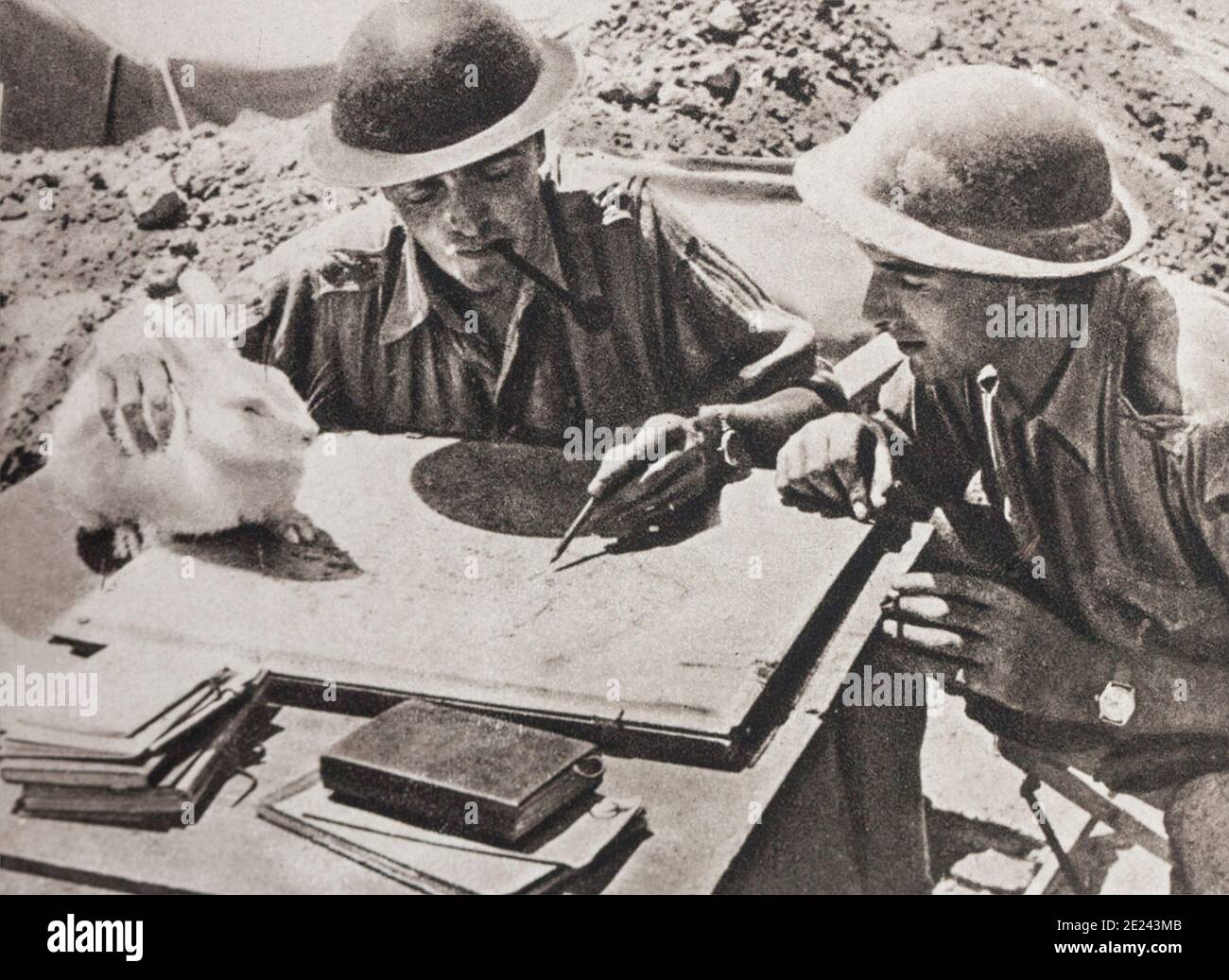 WWII period. The battle in the desert. This wild rabbit, once entered the camp, was raised to the rank of mascot. Stock Photohttps://www.alamy.com/image-license-details/?v=1https://www.alamy.com/wwii-period-the-battle-in-the-desert-this-wild-rabbit-once-entered-the-camp-was-raised-to-the-rank-of-mascot-image397158507.html
RM2E243MB–WWII period. The battle in the desert. This wild rabbit, once entered the camp, was raised to the rank of mascot.
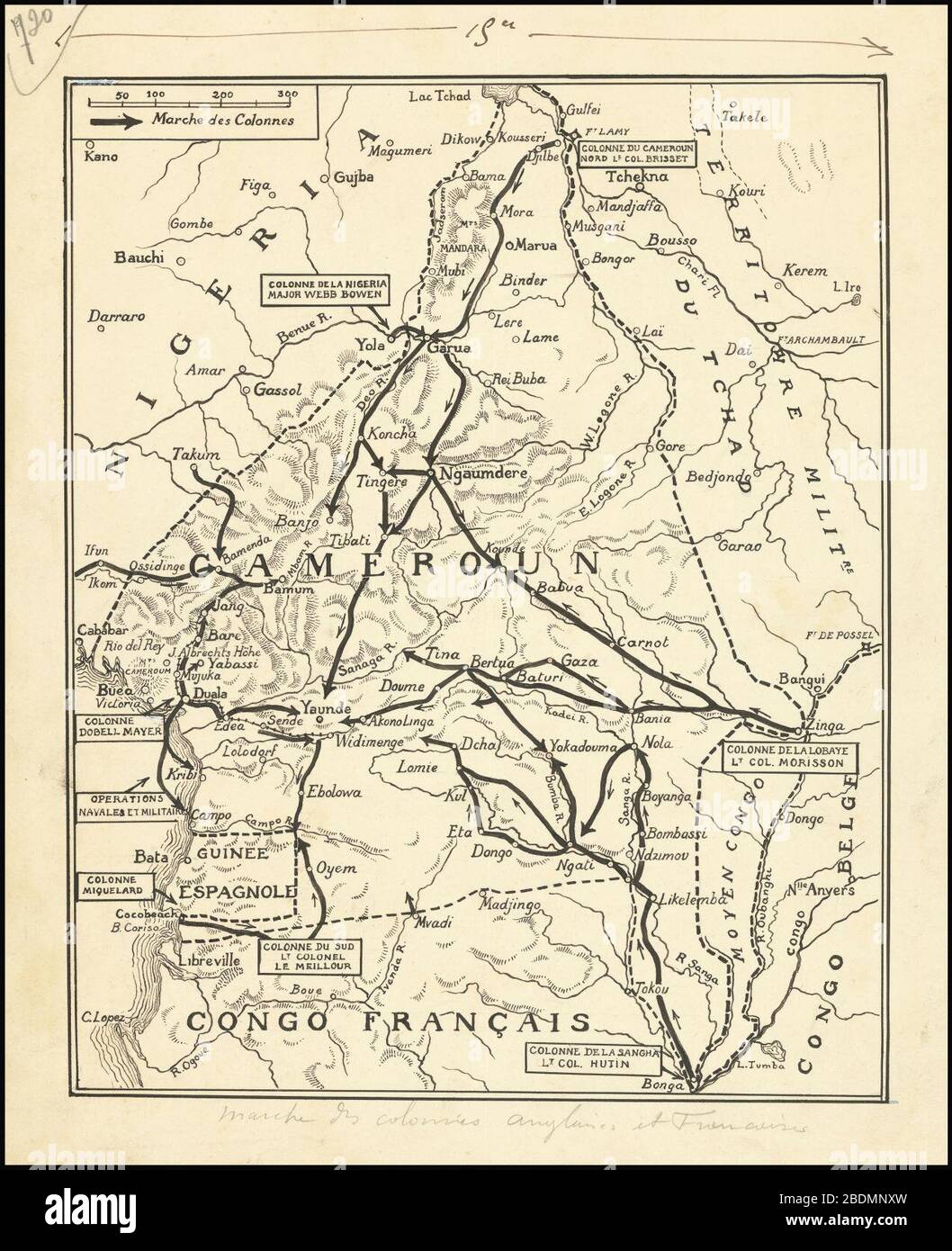 Hand-drawn map of the Kamerun Campaign of World War I in West Africa. Stock Photohttps://www.alamy.com/image-license-details/?v=1https://www.alamy.com/hand-drawn-map-of-the-kamerun-campaign-of-world-war-i-in-west-africa-image352654145.html
RM2BDMNXW–Hand-drawn map of the Kamerun Campaign of World War I in West Africa.
 The Siege of Kimberley from the book ' Boer and Britisher in South Africa; a history of the Boer-British war and the wars for United South Africa, together with biographies of the great men who made the history of South Africa ' By Neville, John Ormond Published by Thompson & Thomas, Chicago, USA in 1900 Stock Photohttps://www.alamy.com/image-license-details/?v=1https://www.alamy.com/the-siege-of-kimberley-from-the-book-boer-and-britisher-in-south-africa-a-history-of-the-boer-british-war-and-the-wars-for-united-south-africa-together-with-biographies-of-the-great-men-who-made-the-history-of-south-africa-by-neville-john-ormond-published-by-thompson-thomas-chicago-usa-in-1900-image413983294.html
RF2F1EFWJ–The Siege of Kimberley from the book ' Boer and Britisher in South Africa; a history of the Boer-British war and the wars for United South Africa, together with biographies of the great men who made the history of South Africa ' By Neville, John Ormond Published by Thompson & Thomas, Chicago, USA in 1900
 Conquest of German Southwest Africa, by General Botha from the book The story of the great war; the complete historical records of events to date DIPLOMATIC AND STATE PAPERS by Reynolds, Francis Joseph, 1867-1937; Churchill, Allen Leon; Miller, Francis Trevelyan, 1877-1959; Wood, Leonard, 1860-1927; Knight, Austin Melvin, 1854-1927; Palmer, Frederick, 1873-1958; Simonds, Frank Herbert, 1878-; Ruhl, Arthur Brown, 1876- Volume III Published 1920 Stock Photohttps://www.alamy.com/image-license-details/?v=1https://www.alamy.com/conquest-of-german-southwest-africa-by-general-botha-from-the-book-the-story-of-the-great-war-the-complete-historical-records-of-events-to-date-diplomatic-and-state-papers-by-reynolds-francis-joseph-1867-1937-churchill-allen-leon-miller-francis-trevelyan-1877-1959-wood-leonard-1860-1927-knight-austin-melvin-1854-1927-palmer-frederick-1873-1958-simonds-frank-herbert-1878-ruhl-arthur-brown-1876-volume-iii-published-1920-image503691400.html
RF2M7D3EG–Conquest of German Southwest Africa, by General Botha from the book The story of the great war; the complete historical records of events to date DIPLOMATIC AND STATE PAPERS by Reynolds, Francis Joseph, 1867-1937; Churchill, Allen Leon; Miller, Francis Trevelyan, 1877-1959; Wood, Leonard, 1860-1927; Knight, Austin Melvin, 1854-1927; Palmer, Frederick, 1873-1958; Simonds, Frank Herbert, 1878-; Ruhl, Arthur Brown, 1876- Volume III Published 1920
!['The Campaign in East Africa', c1916, (c1920). '...map illustrating General Smuts's operations in the heart of the German colony'. The movements of General Jan Smuts, in charge of the British conquest of German East Africa during the First World War, are indicated with arrows. From "The Great World War: A History", Volume VI, edited by Frank A Mumby. [The Gresham Publishing Company Ltd, London, c1920] Stock Photo 'The Campaign in East Africa', c1916, (c1920). '...map illustrating General Smuts's operations in the heart of the German colony'. The movements of General Jan Smuts, in charge of the British conquest of German East Africa during the First World War, are indicated with arrows. From "The Great World War: A History", Volume VI, edited by Frank A Mumby. [The Gresham Publishing Company Ltd, London, c1920] Stock Photo](https://c8.alamy.com/comp/2A8E7M5/the-campaign-in-east-africa-c1916-c1920-map-illustrating-general-smutss-operations-in-the-heart-of-the-german-colony-the-movements-of-general-jan-smuts-in-charge-of-the-british-conquest-of-german-east-africa-during-the-first-world-war-are-indicated-with-arrows-from-quotthe-great-world-war-a-historyquot-volume-vi-edited-by-frank-a-mumby-the-gresham-publishing-company-ltd-london-c1920-2A8E7M5.jpg) 'The Campaign in East Africa', c1916, (c1920). '...map illustrating General Smuts's operations in the heart of the German colony'. The movements of General Jan Smuts, in charge of the British conquest of German East Africa during the First World War, are indicated with arrows. From "The Great World War: A History", Volume VI, edited by Frank A Mumby. [The Gresham Publishing Company Ltd, London, c1920] Stock Photohttps://www.alamy.com/image-license-details/?v=1https://www.alamy.com/the-campaign-in-east-africa-c1916-c1920-map-illustrating-general-smutss-operations-in-the-heart-of-the-german-colony-the-movements-of-general-jan-smuts-in-charge-of-the-british-conquest-of-german-east-africa-during-the-first-world-war-are-indicated-with-arrows-from-quotthe-great-world-war-a-historyquot-volume-vi-edited-by-frank-a-mumby-the-gresham-publishing-company-ltd-london-c1920-image332227621.html
'The Campaign in East Africa', c1916, (c1920). '...map illustrating General Smuts's operations in the heart of the German colony'. The movements of General Jan Smuts, in charge of the British conquest of German East Africa during the First World War, are indicated with arrows. From "The Great World War: A History", Volume VI, edited by Frank A Mumby. [The Gresham Publishing Company Ltd, London, c1920] Stock Photohttps://www.alamy.com/image-license-details/?v=1https://www.alamy.com/the-campaign-in-east-africa-c1916-c1920-map-illustrating-general-smutss-operations-in-the-heart-of-the-german-colony-the-movements-of-general-jan-smuts-in-charge-of-the-british-conquest-of-german-east-africa-during-the-first-world-war-are-indicated-with-arrows-from-quotthe-great-world-war-a-historyquot-volume-vi-edited-by-frank-a-mumby-the-gresham-publishing-company-ltd-london-c1920-image332227621.htmlRM2A8E7M5–'The Campaign in East Africa', c1916, (c1920). '...map illustrating General Smuts's operations in the heart of the German colony'. The movements of General Jan Smuts, in charge of the British conquest of German East Africa during the First World War, are indicated with arrows. From "The Great World War: A History", Volume VI, edited by Frank A Mumby. [The Gresham Publishing Company Ltd, London, c1920]
RF2RH12ME–SIERRA LEONE Map and raised fists. National day or Independence day design for SIERRA LEONE celebration. Modern retro design with abstract icons.
 Postage stamp from Mali depicting a grasshopper and a map of Africa, issued for an anti-locust campaign. Stock Photohttps://www.alamy.com/image-license-details/?v=1https://www.alamy.com/stock-photo-postage-stamp-from-mali-depicting-a-grasshopper-and-a-map-of-africa-51206034.html
RMCY8HPX–Postage stamp from Mali depicting a grasshopper and a map of Africa, issued for an anti-locust campaign.
 Madagascar map on a Rastafarian flag button Stock Photohttps://www.alamy.com/image-license-details/?v=1https://www.alamy.com/stock-image-madagascar-map-on-a-rastafarian-flag-button-169191729.html
RFKR79NN–Madagascar map on a Rastafarian flag button
 Find your roots banner illustration, handmade planet earth with green world map made of tree root branch. Eco friendly campaign or community identity Stock Vectorhttps://www.alamy.com/image-license-details/?v=1https://www.alamy.com/find-your-roots-banner-illustration-handmade-planet-earth-with-green-world-map-made-of-tree-root-branch-eco-friendly-campaign-or-community-identity-image361827398.html
RF2C0JJF2–Find your roots banner illustration, handmade planet earth with green world map made of tree root branch. Eco friendly campaign or community identity
 Africa Industrialization Day is intended to mobilize the commitment of the international community to the industrialization of Africa. Stock Vectorhttps://www.alamy.com/image-license-details/?v=1https://www.alamy.com/africa-industrialization-day-is-intended-to-mobilize-the-commitment-of-the-international-community-to-the-industrialization-of-africa-image387154006.html
RF2DDTATP–Africa Industrialization Day is intended to mobilize the commitment of the international community to the industrialization of Africa.
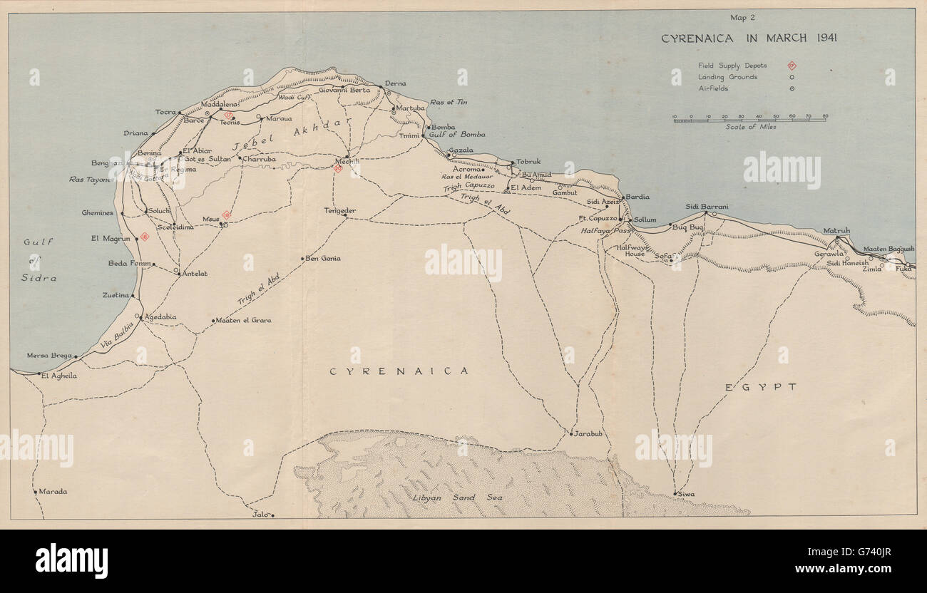 WW2 NORTH AFRICA CAMPAIGN. Cyrenaica in March 1941. Libya, 1956 vintage map Stock Photohttps://www.alamy.com/image-license-details/?v=1https://www.alamy.com/stock-photo-ww2-north-africa-campaign-cyrenaica-in-march-1941-libya-1956-vintage-107653135.html
RFG740JR–WW2 NORTH AFRICA CAMPAIGN. Cyrenaica in March 1941. Libya, 1956 vintage map
![Title: German East African Exhibit, Campaign Double Tent. [Photographs, casts, and map of German East Africa]. [Palace of Agriculture]. (1904 World's Fair). . 1904. Stock Photo Title: German East African Exhibit, Campaign Double Tent. [Photographs, casts, and map of German East Africa]. [Palace of Agriculture]. (1904 World's Fair). . 1904. Stock Photo](https://c8.alamy.com/comp/MAKH0T/title-german-east-african-exhibit-campaign-double-tent-photographs-casts-and-map-of-german-east-africa-palace-of-agriculture-1904-worlds-fair-1904-MAKH0T.jpg) Title: German East African Exhibit, Campaign Double Tent. [Photographs, casts, and map of German East Africa]. [Palace of Agriculture]. (1904 World's Fair). . 1904. Stock Photohttps://www.alamy.com/image-license-details/?v=1https://www.alamy.com/title-german-east-african-exhibit-campaign-double-tent-photographs-casts-and-map-of-german-east-africa-palace-of-agriculture-1904-worlds-fair-1904-image178680680.html
Title: German East African Exhibit, Campaign Double Tent. [Photographs, casts, and map of German East Africa]. [Palace of Agriculture]. (1904 World's Fair). . 1904. Stock Photohttps://www.alamy.com/image-license-details/?v=1https://www.alamy.com/title-german-east-african-exhibit-campaign-double-tent-photographs-casts-and-map-of-german-east-africa-palace-of-agriculture-1904-worlds-fair-1904-image178680680.htmlRMMAKH0T–Title: German East African Exhibit, Campaign Double Tent. [Photographs, casts, and map of German East Africa]. [Palace of Agriculture]. (1904 World's Fair). . 1904.
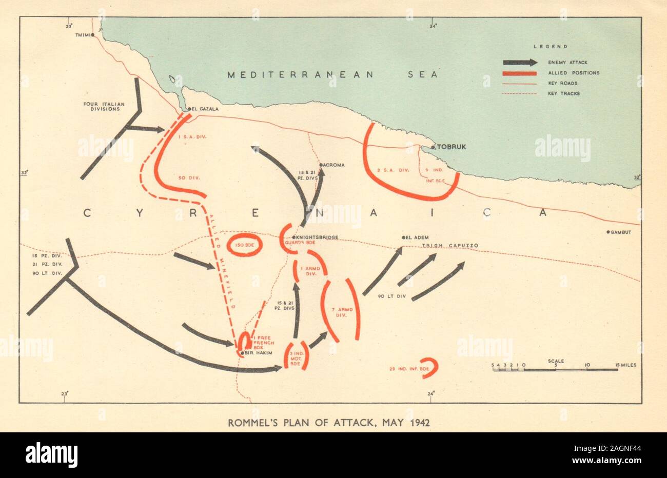 Battle of Gazala. North Africa Campaign. Rommel's attack May 1942. WW2 1954 map Stock Photohttps://www.alamy.com/image-license-details/?v=1https://www.alamy.com/battle-of-gazala-north-africa-campaign-rommels-attack-may-1942-ww2-1954-map-image337304356.html
RF2AGNF44–Battle of Gazala. North Africa Campaign. Rommel's attack May 1942. WW2 1954 map
 An illustration of African Liberation Day with African map and chain breaking. Vector illustration EPS.8 EPS.10 Stock Vectorhttps://www.alamy.com/image-license-details/?v=1https://www.alamy.com/an-illustration-of-african-liberation-day-with-african-map-and-chain-breaking-vector-illustration-eps8-eps10-image449698814.html
RF2H3HFBX–An illustration of African Liberation Day with African map and chain breaking. Vector illustration EPS.8 EPS.10
 Continent of Africa flag button in Rastafarian colours on a white background. Stock Photohttps://www.alamy.com/image-license-details/?v=1https://www.alamy.com/stock-photo-continent-of-africa-flag-button-in-rastafarian-colours-on-a-white-114242700.html
RMGHT5MC–Continent of Africa flag button in Rastafarian colours on a white background.
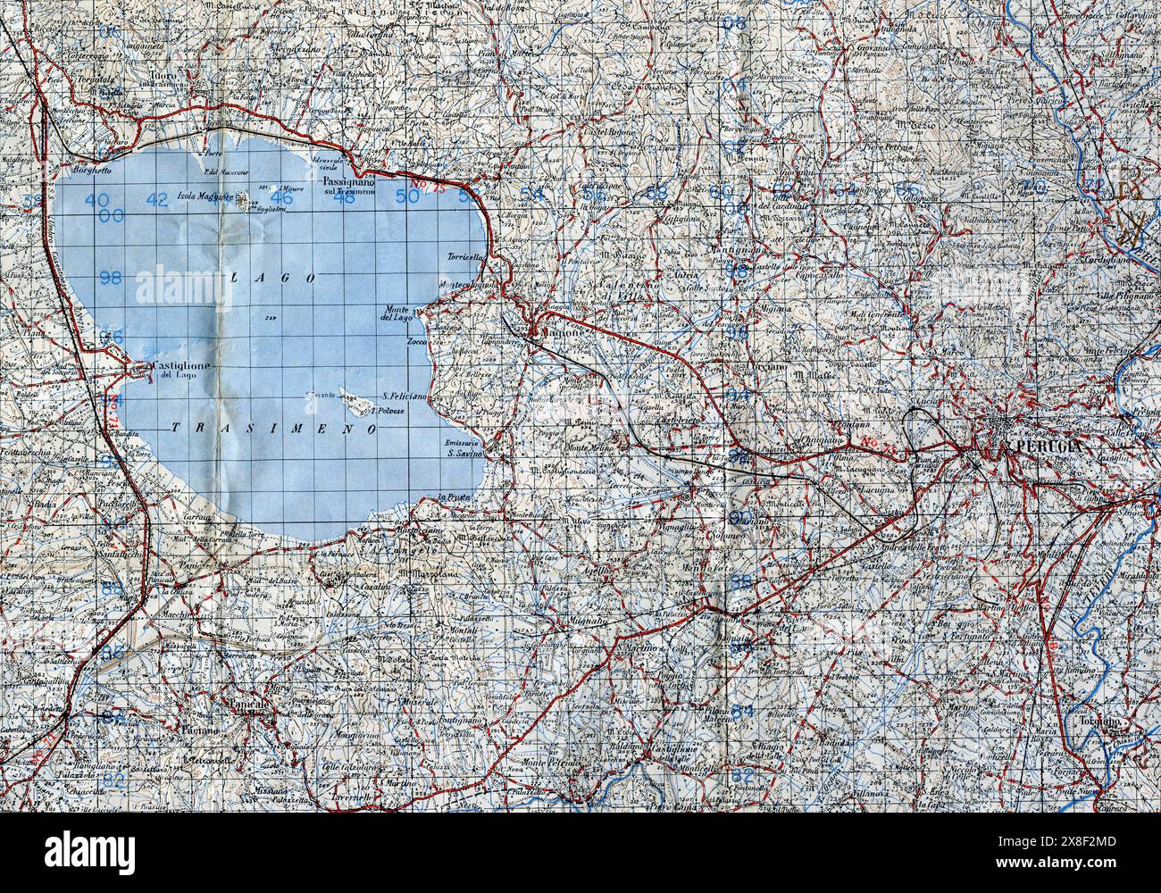 Exerpt of Map Sheet 122(1:100000 scale) of Perugia, Umrbia, Italy from GSGS (Geographical Section, General Staff) 4164 series. It was reproduced by 49 Survey Company S.A.E.C. (South African Survey Company) in April 1944. It illustrates the perational area for 6th Armoured Division during late June and early July 1944. Stock Photohttps://www.alamy.com/image-license-details/?v=1https://www.alamy.com/exerpt-of-map-sheet-1221100000-scale-of-perugia-umrbia-italy-from-gsgs-geographical-section-general-staff-4164-series-it-was-reproduced-by-49-survey-company-saec-south-african-survey-company-in-april-1944-it-illustrates-the-perational-area-for-6th-armoured-division-during-late-june-and-early-july-1944-image607611549.html
RM2X8F2MD–Exerpt of Map Sheet 122(1:100000 scale) of Perugia, Umrbia, Italy from GSGS (Geographical Section, General Staff) 4164 series. It was reproduced by 49 Survey Company S.A.E.C. (South African Survey Company) in April 1944. It illustrates the perational area for 6th Armoured Division during late June and early July 1944.
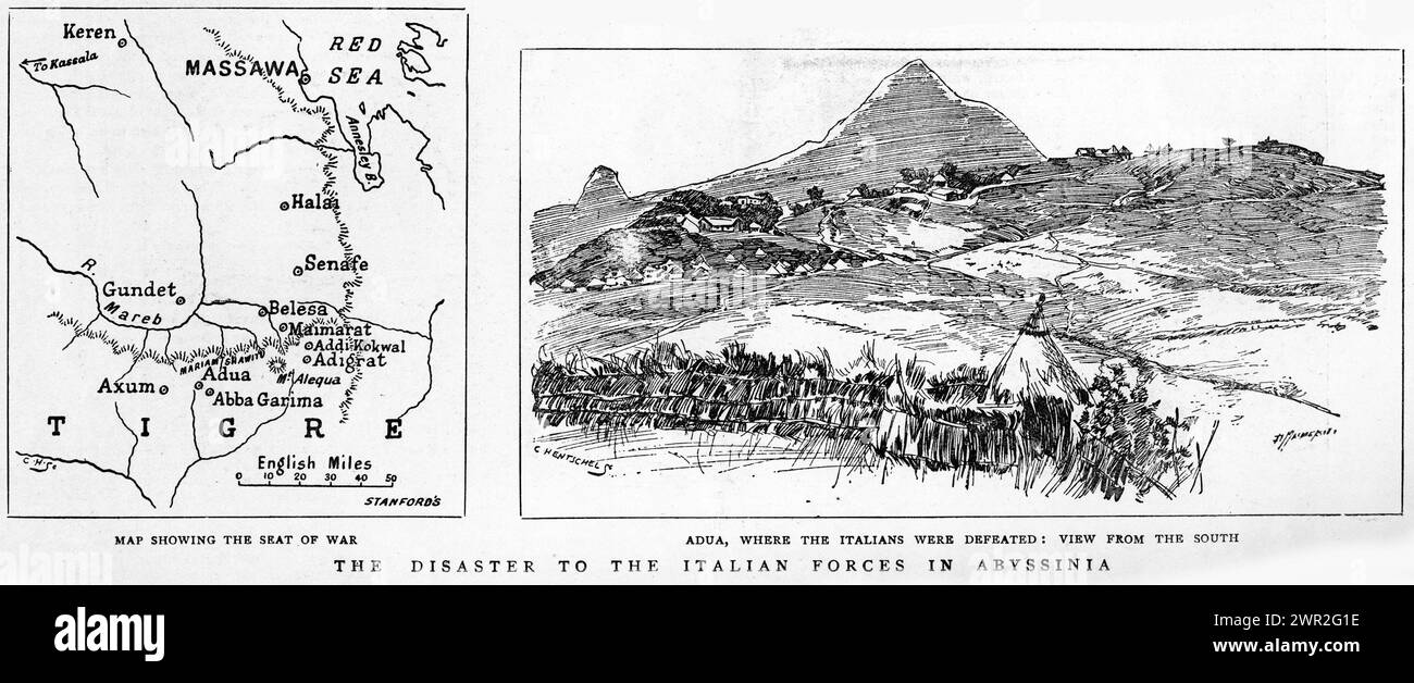 Engraving of the Italian forces defeated in Abyssinia, circa 1896. The Battle of Adwa was the climactic battle of the First Italo-Ethiopian War. The Ethiopian forces defeated the Italian invading force on Sunday 1 March 1896, near the town of Adwa, ending Italian plans to dominate the country.. Stock Photohttps://www.alamy.com/image-license-details/?v=1https://www.alamy.com/engraving-of-the-italian-forces-defeated-in-abyssinia-circa-1896-the-battle-of-adwa-was-the-climactic-battle-of-the-first-italo-ethiopian-war-the-ethiopian-forces-defeated-the-italian-invading-force-on-sunday-1-march-1896-near-the-town-of-adwa-ending-italian-plans-to-dominate-the-country-image599346090.html
RM2WR2G1E–Engraving of the Italian forces defeated in Abyssinia, circa 1896. The Battle of Adwa was the climactic battle of the First Italo-Ethiopian War. The Ethiopian forces defeated the Italian invading force on Sunday 1 March 1896, near the town of Adwa, ending Italian plans to dominate the country..
 South Africa map on a Rastafarian flag button Stock Photohttps://www.alamy.com/image-license-details/?v=1https://www.alamy.com/stock-image-south-africa-map-on-a-rastafarian-flag-button-169191685.html
RFKR79M5–South Africa map on a Rastafarian flag button
 GENERAL MONTGOMERY TELLS R.A.F. OFFICERS ABOUT AFRICA VICTORIES : - 10604. Standing before a large map of North Africa, General Sir Bernard Montgomery, lectures on the victorious North African campaign, Royal Air Force Stock Photohttps://www.alamy.com/image-license-details/?v=1https://www.alamy.com/general-montgomery-tells-raf-officers-about-africa-victories-10604-standing-before-a-large-map-of-north-africa-general-sir-bernard-montgomery-lectures-on-the-victorious-north-african-campaign-royal-air-force-image603430090.html
RM2X1MH6J–GENERAL MONTGOMERY TELLS R.A.F. OFFICERS ABOUT AFRICA VICTORIES : - 10604. Standing before a large map of North Africa, General Sir Bernard Montgomery, lectures on the victorious North African campaign, Royal Air Force
RF2X595A6–Hand hold globe earth. Single continuous line world global map graphic icon. Simple one line doodle for environment campaign concept. Isolated vector
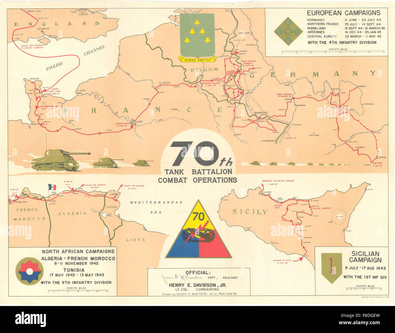 70th Tank Battalion Combat Operations Campaign Map for North Africa Sicily and Europe 1942-1945. Stock Photohttps://www.alamy.com/image-license-details/?v=1https://www.alamy.com/70th-tank-battalion-combat-operations-campaign-map-for-north-africa-sicily-and-europe-1942-1945-image211740001.html
RMP8DGEW–70th Tank Battalion Combat Operations Campaign Map for North Africa Sicily and Europe 1942-1945.
RF2X4R7RP–Hand hold globe earth. Single continuous line world global map graphic icon. Simple one line doodle for environment campaign concept. Isolated vector
 Africa industrialization day background with africa map isolated on white background. Stock Vectorhttps://www.alamy.com/image-license-details/?v=1https://www.alamy.com/africa-industrialization-day-background-with-africa-map-isolated-on-white-background-image562517928.html
RF2RK4WA0–Africa industrialization day background with africa map isolated on white background.
!['The War in East Africa', 1916, (c1920). '...map illustrating the conquest of Kilimanjaro and the first phase of General Smuts's campaign'. The movements of General Jan Smuts, in charge of the British conquest of German East Africa during the First World War, are indicated with arrows. From "The Great World War: A History", Volume VI, edited by Frank A Mumby. [The Gresham Publishing Company Ltd, London, c1920] Stock Photo 'The War in East Africa', 1916, (c1920). '...map illustrating the conquest of Kilimanjaro and the first phase of General Smuts's campaign'. The movements of General Jan Smuts, in charge of the British conquest of German East Africa during the First World War, are indicated with arrows. From "The Great World War: A History", Volume VI, edited by Frank A Mumby. [The Gresham Publishing Company Ltd, London, c1920] Stock Photo](https://c8.alamy.com/comp/2A8E7MM/the-war-in-east-africa-1916-c1920-map-illustrating-the-conquest-of-kilimanjaro-and-the-first-phase-of-general-smutss-campaign-the-movements-of-general-jan-smuts-in-charge-of-the-british-conquest-of-german-east-africa-during-the-first-world-war-are-indicated-with-arrows-from-quotthe-great-world-war-a-historyquot-volume-vi-edited-by-frank-a-mumby-the-gresham-publishing-company-ltd-london-c1920-2A8E7MM.jpg) 'The War in East Africa', 1916, (c1920). '...map illustrating the conquest of Kilimanjaro and the first phase of General Smuts's campaign'. The movements of General Jan Smuts, in charge of the British conquest of German East Africa during the First World War, are indicated with arrows. From "The Great World War: A History", Volume VI, edited by Frank A Mumby. [The Gresham Publishing Company Ltd, London, c1920] Stock Photohttps://www.alamy.com/image-license-details/?v=1https://www.alamy.com/the-war-in-east-africa-1916-c1920-map-illustrating-the-conquest-of-kilimanjaro-and-the-first-phase-of-general-smutss-campaign-the-movements-of-general-jan-smuts-in-charge-of-the-british-conquest-of-german-east-africa-during-the-first-world-war-are-indicated-with-arrows-from-quotthe-great-world-war-a-historyquot-volume-vi-edited-by-frank-a-mumby-the-gresham-publishing-company-ltd-london-c1920-image332227636.html
'The War in East Africa', 1916, (c1920). '...map illustrating the conquest of Kilimanjaro and the first phase of General Smuts's campaign'. The movements of General Jan Smuts, in charge of the British conquest of German East Africa during the First World War, are indicated with arrows. From "The Great World War: A History", Volume VI, edited by Frank A Mumby. [The Gresham Publishing Company Ltd, London, c1920] Stock Photohttps://www.alamy.com/image-license-details/?v=1https://www.alamy.com/the-war-in-east-africa-1916-c1920-map-illustrating-the-conquest-of-kilimanjaro-and-the-first-phase-of-general-smutss-campaign-the-movements-of-general-jan-smuts-in-charge-of-the-british-conquest-of-german-east-africa-during-the-first-world-war-are-indicated-with-arrows-from-quotthe-great-world-war-a-historyquot-volume-vi-edited-by-frank-a-mumby-the-gresham-publishing-company-ltd-london-c1920-image332227636.htmlRM2A8E7MM–'The War in East Africa', 1916, (c1920). '...map illustrating the conquest of Kilimanjaro and the first phase of General Smuts's campaign'. The movements of General Jan Smuts, in charge of the British conquest of German East Africa during the First World War, are indicated with arrows. From "The Great World War: A History", Volume VI, edited by Frank A Mumby. [The Gresham Publishing Company Ltd, London, c1920]
RF2RH0XKE–SIERRA LEONE Map and raised fists. National day or Independence day design for SIERRA LEONE celebration. Modern retro design with abstract icons.
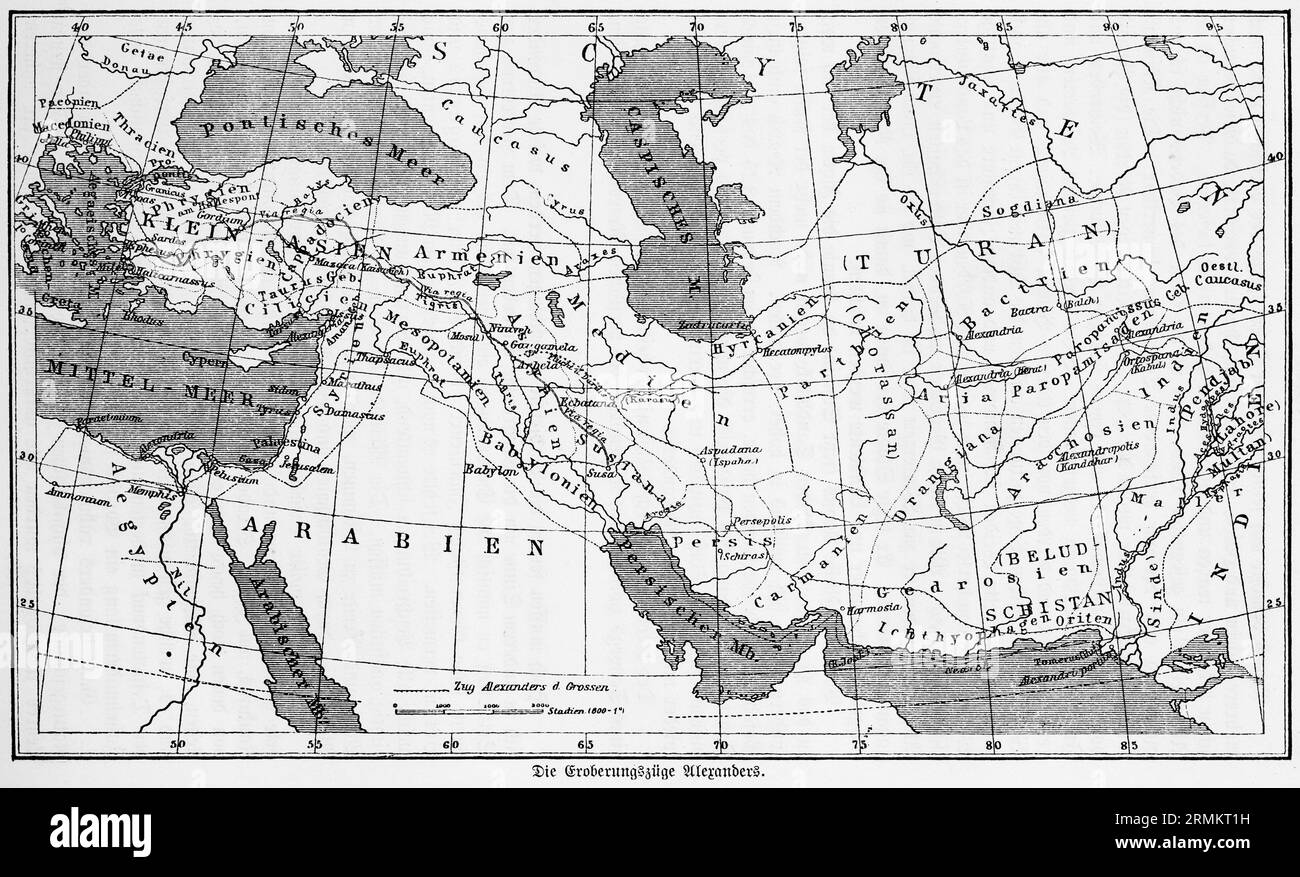 The conquests of Alexander, historical map, conquests, campaign, Alexander the Great, Persia, Afghanistan, India, Indus, Euphrates, Tigris, Pontic Stock Photohttps://www.alamy.com/image-license-details/?v=1https://www.alamy.com/the-conquests-of-alexander-historical-map-conquests-campaign-alexander-the-great-persia-afghanistan-india-indus-euphrates-tigris-pontic-image563460845.html
RM2RMKT1H–The conquests of Alexander, historical map, conquests, campaign, Alexander the Great, Persia, Afghanistan, India, Indus, Euphrates, Tigris, Pontic
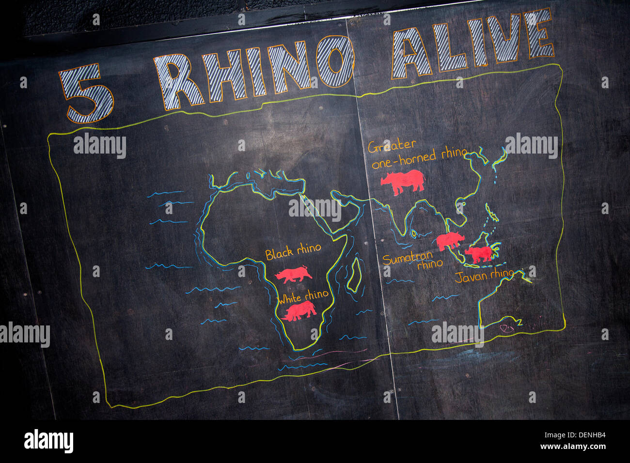 Knowsley Safari Park World Rhino Day. 22nd September, 2013. '5 Rhino Alive' Rhino distribution map at the 'Save the Rhino' event at Knowsley Safari Park, Liverpool. World Rhino Day when Zoos, organizations and reserves around the world campaigned to raise awareness about protecting rhinoceros from deadly poaching... a crisis that continues to threaten animals in Africa and Asia. Rhino horns are valued on the international black market for their purported 'medicinal' values, a demand that is threatening their very survival. Stock Photohttps://www.alamy.com/image-license-details/?v=1https://www.alamy.com/knowsley-safari-park-world-rhino-day-22nd-september-2013-5-rhino-alive-image60710920.html
RMDENHB4–Knowsley Safari Park World Rhino Day. 22nd September, 2013. '5 Rhino Alive' Rhino distribution map at the 'Save the Rhino' event at Knowsley Safari Park, Liverpool. World Rhino Day when Zoos, organizations and reserves around the world campaigned to raise awareness about protecting rhinoceros from deadly poaching... a crisis that continues to threaten animals in Africa and Asia. Rhino horns are valued on the international black market for their purported 'medicinal' values, a demand that is threatening their very survival.
 Find your roots banner illustration, handmade planet earth with green world map made of tree root branch. Eco friendly campaign or community identity Stock Vectorhttps://www.alamy.com/image-license-details/?v=1https://www.alamy.com/find-your-roots-banner-illustration-handmade-planet-earth-with-green-world-map-made-of-tree-root-branch-eco-friendly-campaign-or-community-identity-image361827395.html
RF2C0JJEY–Find your roots banner illustration, handmade planet earth with green world map made of tree root branch. Eco friendly campaign or community identity
 Africa Industrialization Day is intended to mobilize the commitment of the international community to the industrialization of Africa. Stock Vectorhttps://www.alamy.com/image-license-details/?v=1https://www.alamy.com/africa-industrialization-day-is-intended-to-mobilize-the-commitment-of-the-international-community-to-the-industrialization-of-africa-image387153950.html
RF2DDTAPP–Africa Industrialization Day is intended to mobilize the commitment of the international community to the industrialization of Africa.
 World Population Day, creative concept. Large and diverse group of people in the shape of the world map Stock Photohttps://www.alamy.com/image-license-details/?v=1https://www.alamy.com/world-population-day-creative-concept-large-and-diverse-group-of-people-in-the-shape-of-the-world-map-image553286664.html
RF2R44AP0–World Population Day, creative concept. Large and diverse group of people in the shape of the world map
 Nelson Mandela International Day July 18th , drawing of a raised fist on a map of Africa with its green, blue, red and yellow flag. Stock Vectorhttps://www.alamy.com/image-license-details/?v=1https://www.alamy.com/nelson-mandela-international-day-july-18th-drawing-of-a-raised-fist-on-a-map-of-africa-with-its-green-blue-red-and-yellow-flag-image433421010.html
RF2G540WP–Nelson Mandela International Day July 18th , drawing of a raised fist on a map of Africa with its green, blue, red and yellow flag.
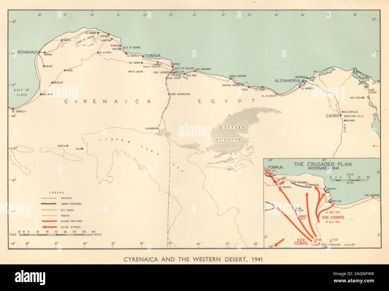 North Africa Campaign 1941. Crusader. Western Desert. World War 2 Libya 1954 map Stock Photohttps://www.alamy.com/image-license-details/?v=1https://www.alamy.com/north-africa-campaign-1941-crusader-western-desert-world-war-2-libya-1954-map-image337304377.html
RF2AGNF4W–North Africa Campaign 1941. Crusader. Western Desert. World War 2 Libya 1954 map
 View of the map of the 'Fortress Tobruk' in Libya, published on 1 July 1941. Fotoarchiv für Zeitgeschichte Stock Photohttps://www.alamy.com/image-license-details/?v=1https://www.alamy.com/view-of-the-map-of-the-fortress-tobruk-in-libya-published-on-1-july-image60932252.html
RMDF3KKT–View of the map of the 'Fortress Tobruk' in Libya, published on 1 July 1941. Fotoarchiv für Zeitgeschichte
 Gabon map on a Rastafarian flag button, white background. Stock Photohttps://www.alamy.com/image-license-details/?v=1https://www.alamy.com/stock-photo-gabon-map-on-a-rastafarian-flag-button-white-background-114287658.html
RMGHX722–Gabon map on a Rastafarian flag button, white background.
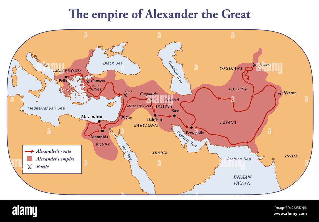 The empire, route and battles of Alexander the great from Greece to India Stock Photohttps://www.alamy.com/image-license-details/?v=1https://www.alamy.com/the-empire-route-and-battles-of-alexander-the-great-from-greece-to-india-image502473166.html
RF2M5DHJ6–The empire, route and battles of Alexander the great from Greece to India
 Hand drawn flat world polio day illustration Vector illustration. Stock Vectorhttps://www.alamy.com/image-license-details/?v=1https://www.alamy.com/hand-drawn-flat-world-polio-day-illustration-vector-illustration-image440057972.html
RF2GFXAC4–Hand drawn flat world polio day illustration Vector illustration.
 Burundi map on a Rastafarian flag button Stock Photohttps://www.alamy.com/image-license-details/?v=1https://www.alamy.com/stock-image-burundi-map-on-a-rastafarian-flag-button-169191486.html
RFKR79D2–Burundi map on a Rastafarian flag button
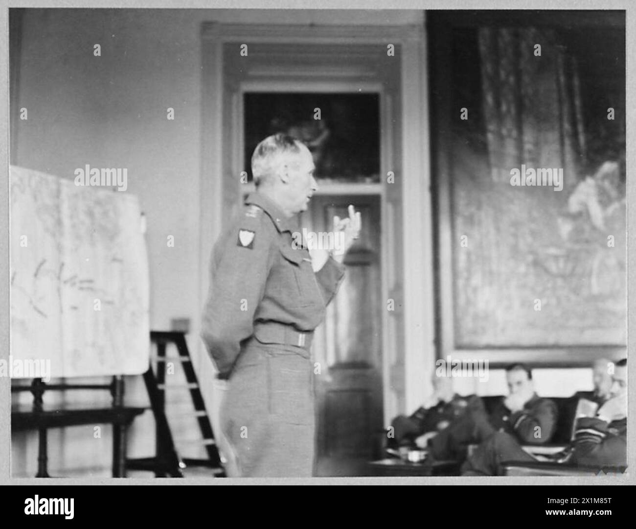 GENERAL MONTGOMERY TELLS R.A.F. OFFICERS ABOUT AFRICA VICTORIES : - 10604. Standing before a large map of North Africa, General Sir Bernard Montgomery, lectures on the victorious North African campaign, Royal Air Force Stock Photohttps://www.alamy.com/image-license-details/?v=1https://www.alamy.com/general-montgomery-tells-raf-officers-about-africa-victories-10604-standing-before-a-large-map-of-north-africa-general-sir-bernard-montgomery-lectures-on-the-victorious-north-african-campaign-royal-air-force-image603423012.html
RM2X1M85T–GENERAL MONTGOMERY TELLS R.A.F. OFFICERS ABOUT AFRICA VICTORIES : - 10604. Standing before a large map of North Africa, General Sir Bernard Montgomery, lectures on the victorious North African campaign, Royal Air Force
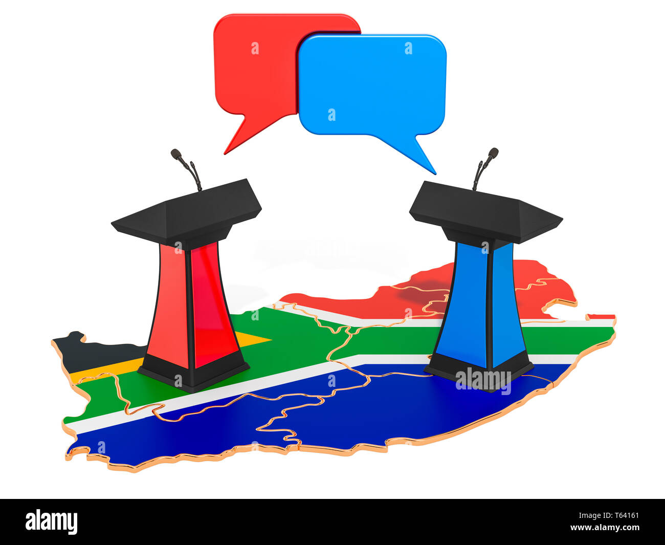 South Africa Debate concept, 3D rendering isolated on white background Stock Photohttps://www.alamy.com/image-license-details/?v=1https://www.alamy.com/south-africa-debate-concept-3d-rendering-isolated-on-white-background-image244721849.html
RFT64161–South Africa Debate concept, 3D rendering isolated on white background
 5 of 'Narrative of a Voyage of Observation among the Colonies of Western Africa ... and of a campaign in Kaffir-Land ... in 18 Stock Photohttps://www.alamy.com/image-license-details/?v=1https://www.alamy.com/stock-photo-5-of-narrative-of-a-voyage-of-observation-among-the-colonies-of-western-95711524.html
RFFFM10M–5 of 'Narrative of a Voyage of Observation among the Colonies of Western Africa ... and of a campaign in Kaffir-Land ... in 18
 Africa Industrialization Day Background Illustration Stock Vectorhttps://www.alamy.com/image-license-details/?v=1https://www.alamy.com/africa-industrialization-day-background-illustration-image440679423.html
RF2GGXK2R–Africa Industrialization Day Background Illustration
 Africa industrialization day background with factory and africa map on white color. Stock Vectorhttps://www.alamy.com/image-license-details/?v=1https://www.alamy.com/africa-industrialization-day-background-with-factory-and-africa-map-on-white-color-image562515983.html
RF2RK4PTF–Africa industrialization day background with factory and africa map on white color.
!['Map Showing the German Cameroon Colony', 1916. German Cameroon was an African colony of the German Empire from 1884 to 1916. Following Germany's defeat, the Treaty of Versailles divided the territory between Great Britain and France. From "The War Illustrated Album De Luxe - Volume IV. The Summer Campaign - 1915", edited by J. A. Hammerton. [The Amalgamated Press, Limited, London, 1916] Stock Photo 'Map Showing the German Cameroon Colony', 1916. German Cameroon was an African colony of the German Empire from 1884 to 1916. Following Germany's defeat, the Treaty of Versailles divided the territory between Great Britain and France. From "The War Illustrated Album De Luxe - Volume IV. The Summer Campaign - 1915", edited by J. A. Hammerton. [The Amalgamated Press, Limited, London, 1916] Stock Photo](https://c8.alamy.com/comp/2A8E9NH/map-showing-the-german-cameroon-colony-1916-german-cameroon-was-an-african-colony-of-the-german-empire-from-1884-to-1916-following-germanys-defeat-the-treaty-of-versailles-divided-the-territory-between-great-britain-and-france-from-quotthe-war-illustrated-album-de-luxe-volume-iv-the-summer-campaign-1915quot-edited-by-j-a-hammerton-the-amalgamated-press-limited-london-1916-2A8E9NH.jpg) 'Map Showing the German Cameroon Colony', 1916. German Cameroon was an African colony of the German Empire from 1884 to 1916. Following Germany's defeat, the Treaty of Versailles divided the territory between Great Britain and France. From "The War Illustrated Album De Luxe - Volume IV. The Summer Campaign - 1915", edited by J. A. Hammerton. [The Amalgamated Press, Limited, London, 1916] Stock Photohttps://www.alamy.com/image-license-details/?v=1https://www.alamy.com/map-showing-the-german-cameroon-colony-1916-german-cameroon-was-an-african-colony-of-the-german-empire-from-1884-to-1916-following-germanys-defeat-the-treaty-of-versailles-divided-the-territory-between-great-britain-and-france-from-quotthe-war-illustrated-album-de-luxe-volume-iv-the-summer-campaign-1915quot-edited-by-j-a-hammerton-the-amalgamated-press-limited-london-1916-image332229229.html
'Map Showing the German Cameroon Colony', 1916. German Cameroon was an African colony of the German Empire from 1884 to 1916. Following Germany's defeat, the Treaty of Versailles divided the territory between Great Britain and France. From "The War Illustrated Album De Luxe - Volume IV. The Summer Campaign - 1915", edited by J. A. Hammerton. [The Amalgamated Press, Limited, London, 1916] Stock Photohttps://www.alamy.com/image-license-details/?v=1https://www.alamy.com/map-showing-the-german-cameroon-colony-1916-german-cameroon-was-an-african-colony-of-the-german-empire-from-1884-to-1916-following-germanys-defeat-the-treaty-of-versailles-divided-the-territory-between-great-britain-and-france-from-quotthe-war-illustrated-album-de-luxe-volume-iv-the-summer-campaign-1915quot-edited-by-j-a-hammerton-the-amalgamated-press-limited-london-1916-image332229229.htmlRM2A8E9NH–'Map Showing the German Cameroon Colony', 1916. German Cameroon was an African colony of the German Empire from 1884 to 1916. Following Germany's defeat, the Treaty of Versailles divided the territory between Great Britain and France. From "The War Illustrated Album De Luxe - Volume IV. The Summer Campaign - 1915", edited by J. A. Hammerton. [The Amalgamated Press, Limited, London, 1916]
 SIERRA LEONE national day banner with map, flag colors theme background and geometric abstract retro modern colorfull design with raised hands or fist Stock Vectorhttps://www.alamy.com/image-license-details/?v=1https://www.alamy.com/sierra-leone-national-day-banner-with-map-flag-colors-theme-background-and-geometric-abstract-retro-modern-colorfull-design-with-raised-hands-or-fist-image565707450.html
RF2RTA5HE–SIERRA LEONE national day banner with map, flag colors theme background and geometric abstract retro modern colorfull design with raised hands or fist
!['German Colonies in West Africa at the Outbreak of War, 1914', (c1920). Map of African territory occupied by European powers at the start of the First World War, including French West Africa, Gold Coast Colony, Togoland, Nigeria, Cameroon, Spanish Guinea, French Equatorial Africa and the Belgian Congo. Also shown is the 'Slave Coast'. From "The Great World War: A History", Volume V, edited by Frank A Mumby. [The Gresham Publishing Company Ltd, London, c1920] Stock Photo 'German Colonies in West Africa at the Outbreak of War, 1914', (c1920). Map of African territory occupied by European powers at the start of the First World War, including French West Africa, Gold Coast Colony, Togoland, Nigeria, Cameroon, Spanish Guinea, French Equatorial Africa and the Belgian Congo. Also shown is the 'Slave Coast'. From "The Great World War: A History", Volume V, edited by Frank A Mumby. [The Gresham Publishing Company Ltd, London, c1920] Stock Photo](https://c8.alamy.com/comp/2A8E7CM/german-colonies-in-west-africa-at-the-outbreak-of-war-1914-c1920-map-of-african-territory-occupied-by-european-powers-at-the-start-of-the-first-world-war-including-french-west-africa-gold-coast-colony-togoland-nigeria-cameroon-spanish-guinea-french-equatorial-africa-and-the-belgian-congo-also-shown-is-the-slave-coast-from-quotthe-great-world-war-a-historyquot-volume-v-edited-by-frank-a-mumby-the-gresham-publishing-company-ltd-london-c1920-2A8E7CM.jpg) 'German Colonies in West Africa at the Outbreak of War, 1914', (c1920). Map of African territory occupied by European powers at the start of the First World War, including French West Africa, Gold Coast Colony, Togoland, Nigeria, Cameroon, Spanish Guinea, French Equatorial Africa and the Belgian Congo. Also shown is the 'Slave Coast'. From "The Great World War: A History", Volume V, edited by Frank A Mumby. [The Gresham Publishing Company Ltd, London, c1920] Stock Photohttps://www.alamy.com/image-license-details/?v=1https://www.alamy.com/german-colonies-in-west-africa-at-the-outbreak-of-war-1914-c1920-map-of-african-territory-occupied-by-european-powers-at-the-start-of-the-first-world-war-including-french-west-africa-gold-coast-colony-togoland-nigeria-cameroon-spanish-guinea-french-equatorial-africa-and-the-belgian-congo-also-shown-is-the-slave-coast-from-quotthe-great-world-war-a-historyquot-volume-v-edited-by-frank-a-mumby-the-gresham-publishing-company-ltd-london-c1920-image332227412.html
'German Colonies in West Africa at the Outbreak of War, 1914', (c1920). Map of African territory occupied by European powers at the start of the First World War, including French West Africa, Gold Coast Colony, Togoland, Nigeria, Cameroon, Spanish Guinea, French Equatorial Africa and the Belgian Congo. Also shown is the 'Slave Coast'. From "The Great World War: A History", Volume V, edited by Frank A Mumby. [The Gresham Publishing Company Ltd, London, c1920] Stock Photohttps://www.alamy.com/image-license-details/?v=1https://www.alamy.com/german-colonies-in-west-africa-at-the-outbreak-of-war-1914-c1920-map-of-african-territory-occupied-by-european-powers-at-the-start-of-the-first-world-war-including-french-west-africa-gold-coast-colony-togoland-nigeria-cameroon-spanish-guinea-french-equatorial-africa-and-the-belgian-congo-also-shown-is-the-slave-coast-from-quotthe-great-world-war-a-historyquot-volume-v-edited-by-frank-a-mumby-the-gresham-publishing-company-ltd-london-c1920-image332227412.htmlRM2A8E7CM–'German Colonies in West Africa at the Outbreak of War, 1914', (c1920). Map of African territory occupied by European powers at the start of the First World War, including French West Africa, Gold Coast Colony, Togoland, Nigeria, Cameroon, Spanish Guinea, French Equatorial Africa and the Belgian Congo. Also shown is the 'Slave Coast'. From "The Great World War: A History", Volume V, edited by Frank A Mumby. [The Gresham Publishing Company Ltd, London, c1920]
 Africa Industrialization Day Background Illustration Stock Vectorhttps://www.alamy.com/image-license-details/?v=1https://www.alamy.com/africa-industrialization-day-background-illustration-image440679503.html
RF2GGXK5K–Africa Industrialization Day Background Illustration
 World map made of hand drawn tree root on isolated background. Black and white earth planet roots concept for eco friendly project or environment help Stock Vectorhttps://www.alamy.com/image-license-details/?v=1https://www.alamy.com/world-map-made-of-hand-drawn-tree-root-on-isolated-background-black-and-white-earth-planet-roots-concept-for-eco-friendly-project-or-environment-help-image361827079.html
RF2C0JJ3K–World map made of hand drawn tree root on isolated background. Black and white earth planet roots concept for eco friendly project or environment help
 Africa Industrialization Day. Vector illustration. Suitable for greeting card, poster and banner Stock Vectorhttps://www.alamy.com/image-license-details/?v=1https://www.alamy.com/africa-industrialization-day-vector-illustration-suitable-for-greeting-card-poster-and-banner-image569679901.html
RF2T2R4EN–Africa Industrialization Day. Vector illustration. Suitable for greeting card, poster and banner
 World Population Day, creative concept. Large and diverse group of people in the shape of the world map Stock Photohttps://www.alamy.com/image-license-details/?v=1https://www.alamy.com/world-population-day-creative-concept-large-and-diverse-group-of-people-in-the-shape-of-the-world-map-image553268039.html
RF2R43F0R–World Population Day, creative concept. Large and diverse group of people in the shape of the world map
 Stop Asian Hate Abstract Backdrop with world map in the back and text Stock Photohttps://www.alamy.com/image-license-details/?v=1https://www.alamy.com/stop-asian-hate-abstract-backdrop-with-world-map-in-the-back-and-text-image416839748.html
RF2F64K9T–Stop Asian Hate Abstract Backdrop with world map in the back and text
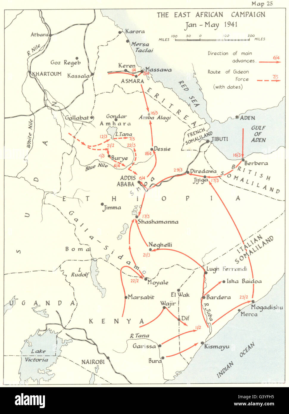 AFRICA: Italians lose initiative in east: African campaign Jan-May 1941 1954 map Stock Photohttps://www.alamy.com/image-license-details/?v=1https://www.alamy.com/stock-photo-africa-italians-lose-initiative-in-east-african-campaign-jan-may-1941-105711121.html
RFG3YFH5–AFRICA: Italians lose initiative in east: African campaign Jan-May 1941 1954 map
 MALI CIRCA 1964: stamp printed by Mali, shows Head of locust and map of Africa, circa 1964 Stock Photohttps://www.alamy.com/image-license-details/?v=1https://www.alamy.com/mali-circa-1964-stamp-printed-by-mali-shows-head-of-locust-and-map-of-africa-circa-1964-image377024039.html
RF2CWAX07–MALI CIRCA 1964: stamp printed by Mali, shows Head of locust and map of Africa, circa 1964
 Congo map on a Rastafarian flag button, white background. Stock Photohttps://www.alamy.com/image-license-details/?v=1https://www.alamy.com/stock-photo-congo-map-on-a-rastafarian-flag-button-white-background-114242670.html
RMGHT5KA–Congo map on a Rastafarian flag button, white background.
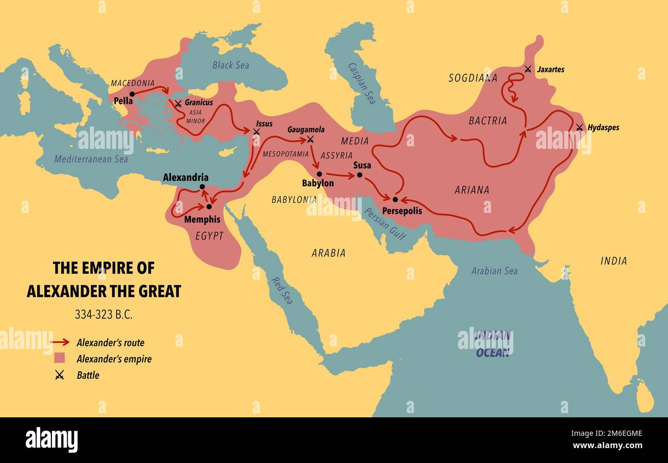 The empire, route and battles of Alexander the great from Greece to India Stock Photohttps://www.alamy.com/image-license-details/?v=1https://www.alamy.com/the-empire-route-and-battles-of-alexander-the-great-from-greece-to-india-image503109054.html
RF2M6EGME–The empire, route and battles of Alexander the great from Greece to India
 British Officers Planning at El Alamein, 1942. Second World War: Egypt. 'The last attack mounted by Rommel against Egypt had brought him heavy losses and a quick pull back. The threat for the time being averted, British staff could concentrate on their own offensive plans'. From "Time To Remember - The End Of The Beginning", 1942 (Reel 3); documentary film about events of 1942 and America's entry into the war. Stock Photohttps://www.alamy.com/image-license-details/?v=1https://www.alamy.com/british-officers-planning-at-el-alamein-1942-second-world-war-egypt-the-last-attack-mounted-by-rommel-against-egypt-had-brought-him-heavy-losses-and-a-quick-pull-back-the-threat-for-the-time-being-averted-british-staff-could-concentrate-on-their-own-offensive-plans-from-quottime-to-remember-the-end-of-the-beginningquot-1942-reel-3-documentary-film-about-events-of-1942-and-americas-entry-into-the-war-image617187021.html
RM2XT389H–British Officers Planning at El Alamein, 1942. Second World War: Egypt. 'The last attack mounted by Rommel against Egypt had brought him heavy losses and a quick pull back. The threat for the time being averted, British staff could concentrate on their own offensive plans'. From "Time To Remember - The End Of The Beginning", 1942 (Reel 3); documentary film about events of 1942 and America's entry into the war.
 Swaziland map on a Rastafarian flag button Stock Photohttps://www.alamy.com/image-license-details/?v=1https://www.alamy.com/stock-image-swaziland-map-on-a-rastafarian-flag-button-169191697.html
RFKR79MH–Swaziland map on a Rastafarian flag button
 An illustration of African Liberation Day with hand breaking the chain Stock Photohttps://www.alamy.com/image-license-details/?v=1https://www.alamy.com/an-illustration-of-african-liberation-day-with-hand-breaking-the-chain-image179289161.html
RFMBK949–An illustration of African Liberation Day with hand breaking the chain
 World Rhino day, 22 September, Rhino day social media template design, banner, ads, post, reel, flyer, poster, banner ads design, vector or stock. Stock Vectorhttps://www.alamy.com/image-license-details/?v=1https://www.alamy.com/world-rhino-day-22-september-rhino-day-social-media-template-design-banner-ads-post-reel-flyer-poster-banner-ads-design-vector-or-stock-image623604339.html
RF2Y6FHKF–World Rhino day, 22 September, Rhino day social media template design, banner, ads, post, reel, flyer, poster, banner ads design, vector or stock.
 Image taken from page 129 of 'Matababeleland and how we got it. With notes on the occupation of Mashunaland and an account of the 1893 campaign by the British South Africa Company, etc' Image taken from page 129 of 'Matababeleland and how we Stock Photohttps://www.alamy.com/image-license-details/?v=1https://www.alamy.com/stock-photo-image-taken-from-page-129-of-matababeleland-and-how-we-got-it-with-127867325.html
RMHC0T25–Image taken from page 129 of 'Matababeleland and how we got it. With notes on the occupation of Mashunaland and an account of the 1893 campaign by the British South Africa Company, etc' Image taken from page 129 of 'Matababeleland and how we
 Green arrows around the world indicating recycling Stock Vectorhttps://www.alamy.com/image-license-details/?v=1https://www.alamy.com/green-arrows-around-the-world-indicating-recycling-image555418218.html
RF2R7HDGX–Green arrows around the world indicating recycling
 Africa industrialization day background with africa map industry isolated on yellow background. Stock Vectorhttps://www.alamy.com/image-license-details/?v=1https://www.alamy.com/africa-industrialization-day-background-with-africa-map-industry-isolated-on-yellow-background-image562516112.html
RF2RK4R14–Africa industrialization day background with africa map industry isolated on yellow background.
 map of the world on dotted silhouette Stock Vectorhttps://www.alamy.com/image-license-details/?v=1https://www.alamy.com/stock-photo-map-of-the-world-on-dotted-silhouette-173765815.html
RFM2KM1Y–map of the world on dotted silhouette
 SIERRA LEONE national day banner with map, flag colors theme background and geometric abstract retro modern colorfull design with raised hands or fist Stock Vectorhttps://www.alamy.com/image-license-details/?v=1https://www.alamy.com/sierra-leone-national-day-banner-with-map-flag-colors-theme-background-and-geometric-abstract-retro-modern-colorfull-design-with-raised-hands-or-fist-image565707399.html
RF2RTA5FK–SIERRA LEONE national day banner with map, flag colors theme background and geometric abstract retro modern colorfull design with raised hands or fist
!['The Conquest of the Cameroons', First World War, 1914-1916, (c1920). '...map showing approximately how the colony was cleared of the German troops, and the scene of the escape of their main force into Spanish Guinea'. Also shown are: 'A, General [Charles Macpherson] Dobell's main columns, with French columns under Colonel Mayer. B, French southern columns. C, Franco-Belgian columns from French Equatorial Africa and Belgian Congo. D, Franco- British columns under Brigadier-General [Frederick Hugh] Cunliffe. E, Northern column under Lieutenant-Colonel Brisset'. German Cameroon was an African co Stock Photo 'The Conquest of the Cameroons', First World War, 1914-1916, (c1920). '...map showing approximately how the colony was cleared of the German troops, and the scene of the escape of their main force into Spanish Guinea'. Also shown are: 'A, General [Charles Macpherson] Dobell's main columns, with French columns under Colonel Mayer. B, French southern columns. C, Franco-Belgian columns from French Equatorial Africa and Belgian Congo. D, Franco- British columns under Brigadier-General [Frederick Hugh] Cunliffe. E, Northern column under Lieutenant-Colonel Brisset'. German Cameroon was an African co Stock Photo](https://c8.alamy.com/comp/2A8E7D3/the-conquest-of-the-cameroons-first-world-war-1914-1916-c1920-map-showing-approximately-how-the-colony-was-cleared-of-the-german-troops-and-the-scene-of-the-escape-of-their-main-force-into-spanish-guinea-also-shown-are-a-general-charles-macpherson-dobells-main-columns-with-french-columns-under-colonel-mayer-b-french-southern-columns-c-franco-belgian-columns-from-french-equatorial-africa-and-belgian-congo-d-franco-british-columns-under-brigadier-general-frederick-hugh-cunliffe-e-northern-column-under-lieutenant-colonel-brisset-german-cameroon-was-an-african-co-2A8E7D3.jpg) 'The Conquest of the Cameroons', First World War, 1914-1916, (c1920). '...map showing approximately how the colony was cleared of the German troops, and the scene of the escape of their main force into Spanish Guinea'. Also shown are: 'A, General [Charles Macpherson] Dobell's main columns, with French columns under Colonel Mayer. B, French southern columns. C, Franco-Belgian columns from French Equatorial Africa and Belgian Congo. D, Franco- British columns under Brigadier-General [Frederick Hugh] Cunliffe. E, Northern column under Lieutenant-Colonel Brisset'. German Cameroon was an African co Stock Photohttps://www.alamy.com/image-license-details/?v=1https://www.alamy.com/the-conquest-of-the-cameroons-first-world-war-1914-1916-c1920-map-showing-approximately-how-the-colony-was-cleared-of-the-german-troops-and-the-scene-of-the-escape-of-their-main-force-into-spanish-guinea-also-shown-are-a-general-charles-macpherson-dobells-main-columns-with-french-columns-under-colonel-mayer-b-french-southern-columns-c-franco-belgian-columns-from-french-equatorial-africa-and-belgian-congo-d-franco-british-columns-under-brigadier-general-frederick-hugh-cunliffe-e-northern-column-under-lieutenant-colonel-brisset-german-cameroon-was-an-african-co-image332227423.html
'The Conquest of the Cameroons', First World War, 1914-1916, (c1920). '...map showing approximately how the colony was cleared of the German troops, and the scene of the escape of their main force into Spanish Guinea'. Also shown are: 'A, General [Charles Macpherson] Dobell's main columns, with French columns under Colonel Mayer. B, French southern columns. C, Franco-Belgian columns from French Equatorial Africa and Belgian Congo. D, Franco- British columns under Brigadier-General [Frederick Hugh] Cunliffe. E, Northern column under Lieutenant-Colonel Brisset'. German Cameroon was an African co Stock Photohttps://www.alamy.com/image-license-details/?v=1https://www.alamy.com/the-conquest-of-the-cameroons-first-world-war-1914-1916-c1920-map-showing-approximately-how-the-colony-was-cleared-of-the-german-troops-and-the-scene-of-the-escape-of-their-main-force-into-spanish-guinea-also-shown-are-a-general-charles-macpherson-dobells-main-columns-with-french-columns-under-colonel-mayer-b-french-southern-columns-c-franco-belgian-columns-from-french-equatorial-africa-and-belgian-congo-d-franco-british-columns-under-brigadier-general-frederick-hugh-cunliffe-e-northern-column-under-lieutenant-colonel-brisset-german-cameroon-was-an-african-co-image332227423.htmlRM2A8E7D3–'The Conquest of the Cameroons', First World War, 1914-1916, (c1920). '...map showing approximately how the colony was cleared of the German troops, and the scene of the escape of their main force into Spanish Guinea'. Also shown are: 'A, General [Charles Macpherson] Dobell's main columns, with French columns under Colonel Mayer. B, French southern columns. C, Franco-Belgian columns from French Equatorial Africa and Belgian Congo. D, Franco- British columns under Brigadier-General [Frederick Hugh] Cunliffe. E, Northern column under Lieutenant-Colonel Brisset'. German Cameroon was an African co
 map of the world on blurred silhouette Stock Vectorhttps://www.alamy.com/image-license-details/?v=1https://www.alamy.com/stock-photo-map-of-the-world-on-blurred-silhouette-173766325.html
RFM2KMM5–map of the world on blurred silhouette
!['The Campaign in German East Africa', 1917. From "The War Illustrated Album De Luxe - Volume VIII. Ending The First Three Years", edited by J. A. Hammerton. [The Amalgamated Press, Limited, London, 1917] Stock Photo 'The Campaign in German East Africa', 1917. From "The War Illustrated Album De Luxe - Volume VIII. Ending The First Three Years", edited by J. A. Hammerton. [The Amalgamated Press, Limited, London, 1917] Stock Photo](https://c8.alamy.com/comp/2A8E9N7/the-campaign-in-german-east-africa-1917-from-quotthe-war-illustrated-album-de-luxe-volume-viii-ending-the-first-three-yearsquot-edited-by-j-a-hammerton-the-amalgamated-press-limited-london-1917-2A8E9N7.jpg) 'The Campaign in German East Africa', 1917. From "The War Illustrated Album De Luxe - Volume VIII. Ending The First Three Years", edited by J. A. Hammerton. [The Amalgamated Press, Limited, London, 1917] Stock Photohttps://www.alamy.com/image-license-details/?v=1https://www.alamy.com/the-campaign-in-german-east-africa-1917-from-quotthe-war-illustrated-album-de-luxe-volume-viii-ending-the-first-three-yearsquot-edited-by-j-a-hammerton-the-amalgamated-press-limited-london-1917-image332229219.html
'The Campaign in German East Africa', 1917. From "The War Illustrated Album De Luxe - Volume VIII. Ending The First Three Years", edited by J. A. Hammerton. [The Amalgamated Press, Limited, London, 1917] Stock Photohttps://www.alamy.com/image-license-details/?v=1https://www.alamy.com/the-campaign-in-german-east-africa-1917-from-quotthe-war-illustrated-album-de-luxe-volume-viii-ending-the-first-three-yearsquot-edited-by-j-a-hammerton-the-amalgamated-press-limited-london-1917-image332229219.htmlRM2A8E9N7–'The Campaign in German East Africa', 1917. From "The War Illustrated Album De Luxe - Volume VIII. Ending The First Three Years", edited by J. A. Hammerton. [The Amalgamated Press, Limited, London, 1917]
 World map made of hand drawn tree root or branch with house, green paint circle on isolated background. Earth planet home concept for united community Stock Vectorhttps://www.alamy.com/image-license-details/?v=1https://www.alamy.com/world-map-made-of-hand-drawn-tree-root-or-branch-with-house-green-paint-circle-on-isolated-background-earth-planet-home-concept-for-united-community-image361827073.html
RF2C0JJ3D–World map made of hand drawn tree root or branch with house, green paint circle on isolated background. Earth planet home concept for united community
 'Map of the Environs of Suakim', c1885. Artist: Unknown. Stock Photohttps://www.alamy.com/image-license-details/?v=1https://www.alamy.com/map-of-the-environs-of-suakim-c1885-artist-unknown-image186093614.html
RMMPN88E–'Map of the Environs of Suakim', c1885. Artist: Unknown.
 World Population Day, creative concept. Large and diverse group of people in the shape of the world map Stock Photohttps://www.alamy.com/image-license-details/?v=1https://www.alamy.com/world-population-day-creative-concept-large-and-diverse-group-of-people-in-the-shape-of-the-world-map-image553268012.html
RF2R43EYT–World Population Day, creative concept. Large and diverse group of people in the shape of the world map
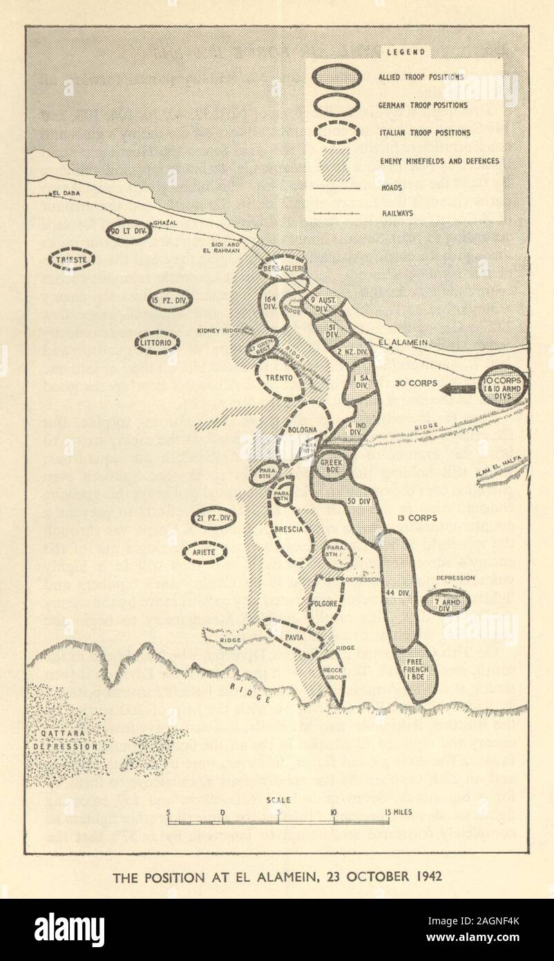 2nd Battle of El Alamein 23 October 1942. WW2 North Africa Campaign 1954 map Stock Photohttps://www.alamy.com/image-license-details/?v=1https://www.alamy.com/2nd-battle-of-el-alamein-23-october-1942-ww2-north-africa-campaign-1954-map-image337304371.html
RF2AGNF4K–2nd Battle of El Alamein 23 October 1942. WW2 North Africa Campaign 1954 map