Quick filters:
Franco prussian war map Stock Photos and Images
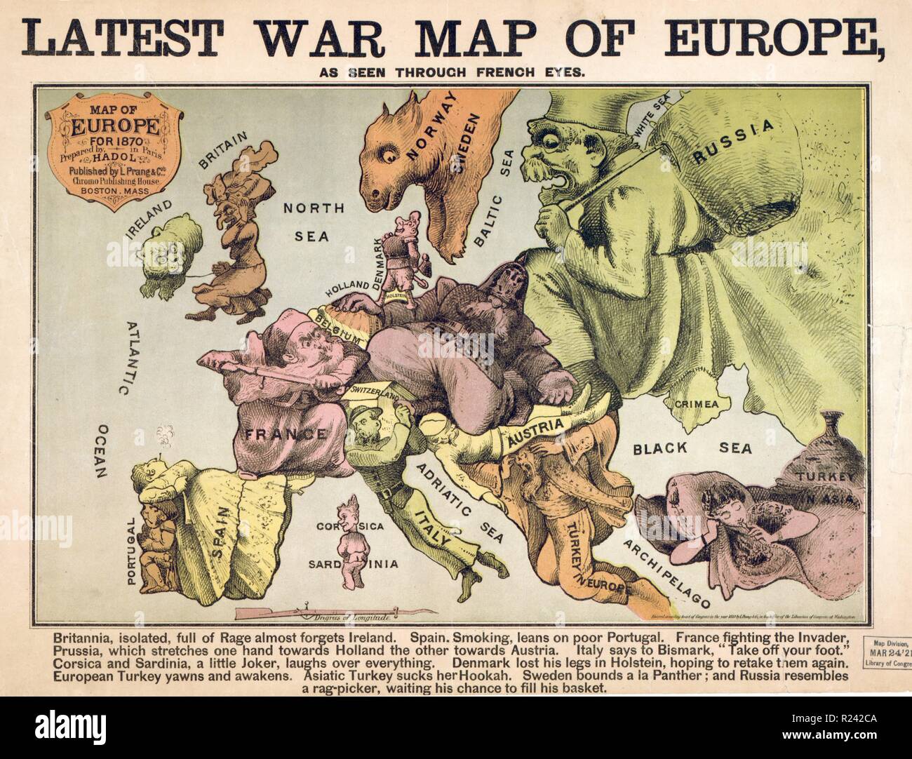 Map of Europe characterising the rival super powers after the Franco-Prussian war 1870 Stock Photohttps://www.alamy.com/image-license-details/?v=1https://www.alamy.com/map-of-europe-characterising-the-rival-super-powers-after-the-franco-prussian-war-1870-image225053818.html
RMR242CA–Map of Europe characterising the rival super powers after the Franco-Prussian war 1870
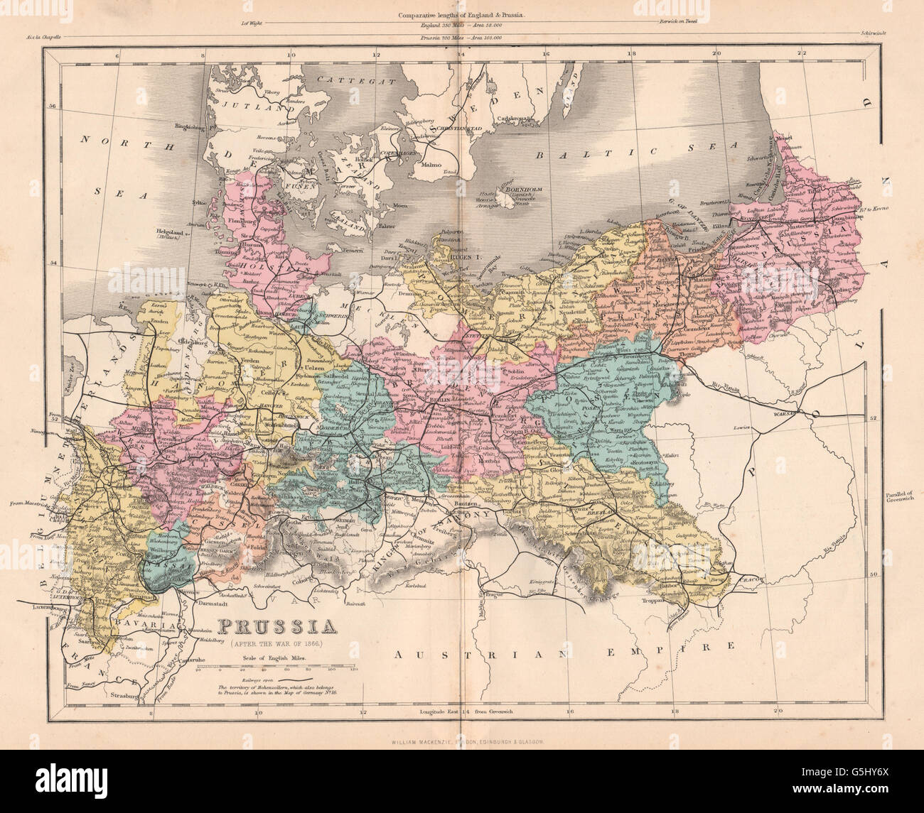 FRANCO-PRUSSIAN WAR: Prussia (After the war of 1866) , 1875 antique map Stock Photohttps://www.alamy.com/image-license-details/?v=1https://www.alamy.com/stock-photo-franco-prussian-war-prussia-after-the-war-of-1866-1875-antique-map-106730034.html
RFG5HY6X–FRANCO-PRUSSIAN WAR: Prussia (After the war of 1866) , 1875 antique map
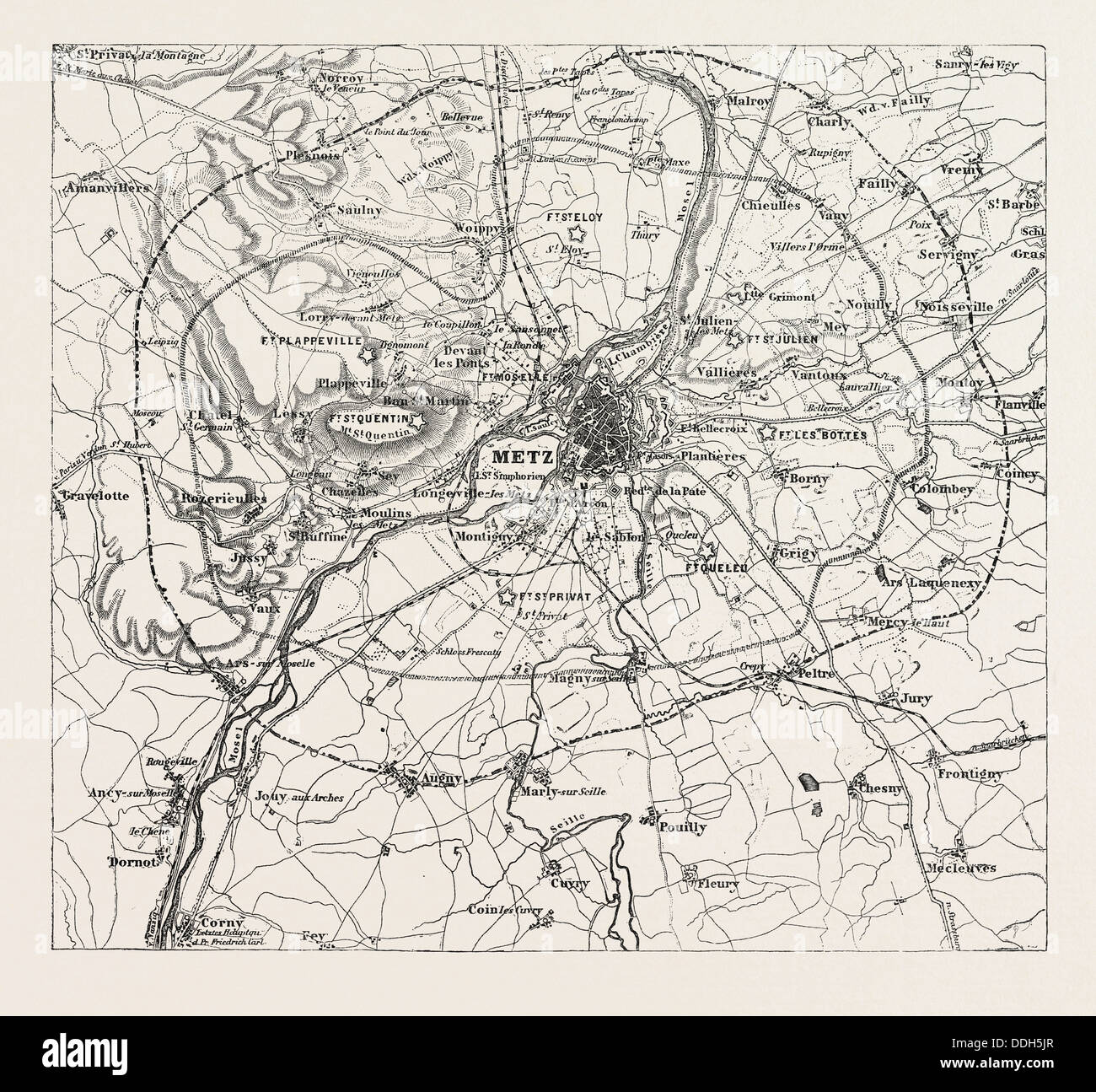 FRANCO-PRUSSIAN WAR: MAP OF VICINITY OF METZ, INDICATING THE POSITION OCCUPIED BY the besieging army 1870 Stock Photohttps://www.alamy.com/image-license-details/?v=1https://www.alamy.com/stock-photo-franco-prussian-war-map-of-vicinity-of-metz-indicating-the-position-59999263.html
RMDDH5JR–FRANCO-PRUSSIAN WAR: MAP OF VICINITY OF METZ, INDICATING THE POSITION OCCUPIED BY the besieging army 1870
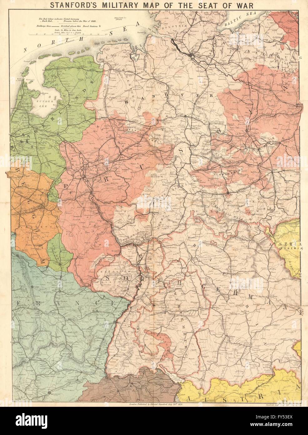 'Stanford's military map of the seat of war'. Franco-Prussian War. Germany 1870 Stock Photohttps://www.alamy.com/image-license-details/?v=1https://www.alamy.com/stock-photo-stanfords-military-map-of-the-seat-of-war-franco-prussian-war-germany-102760082.html
RFFY53EX–'Stanford's military map of the seat of war'. Franco-Prussian War. Germany 1870
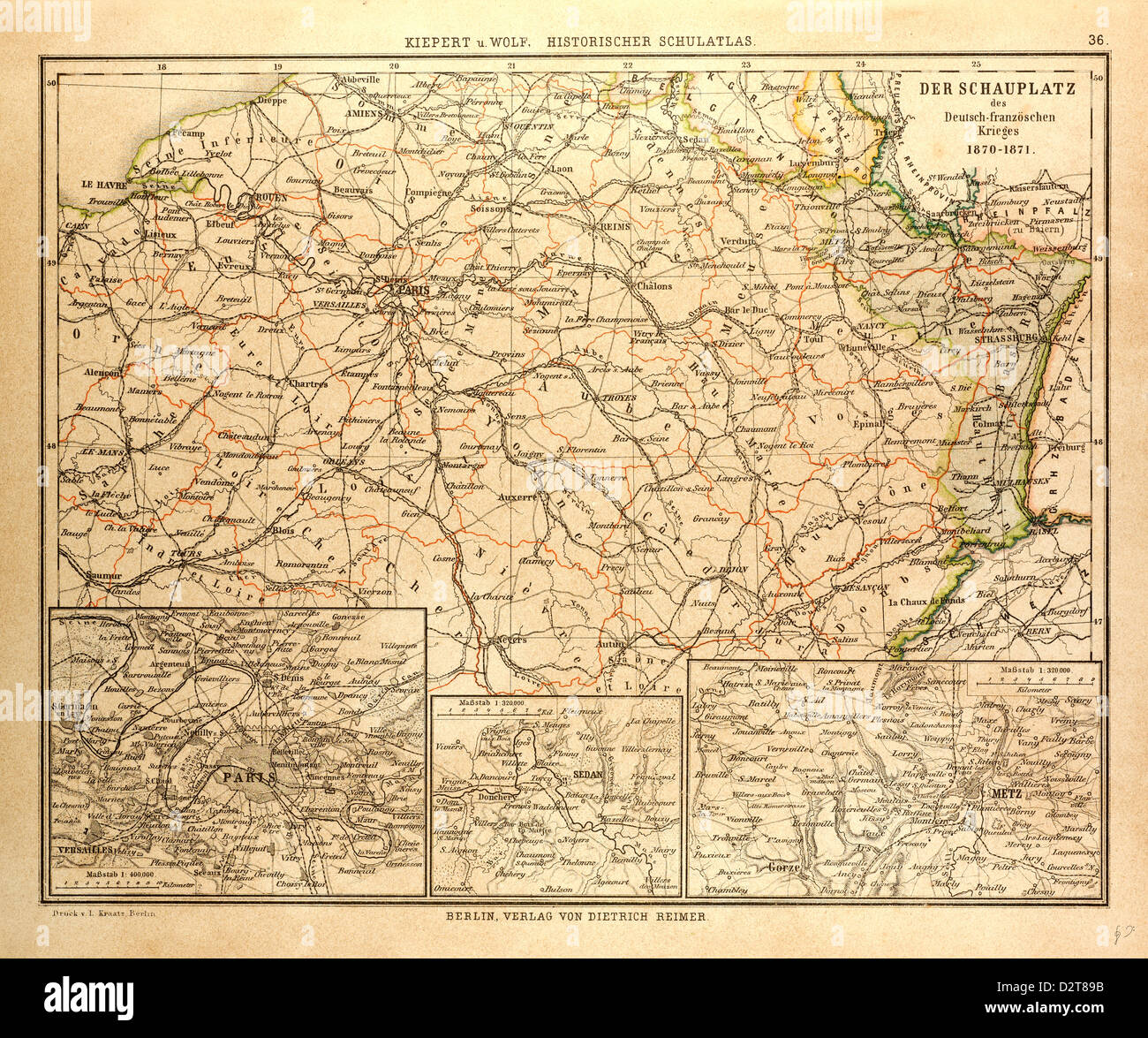 MAP OF WHERE THE FRANCO-PRUSSIAN WAR TOOK PLACE IN FRANCE 1870-1871 Stock Photohttps://www.alamy.com/image-license-details/?v=1https://www.alamy.com/stock-photo-map-of-where-the-franco-prussian-war-took-place-in-france-1870-1871-53393799.html
RMD2T89B–MAP OF WHERE THE FRANCO-PRUSSIAN WAR TOOK PLACE IN FRANCE 1870-1871
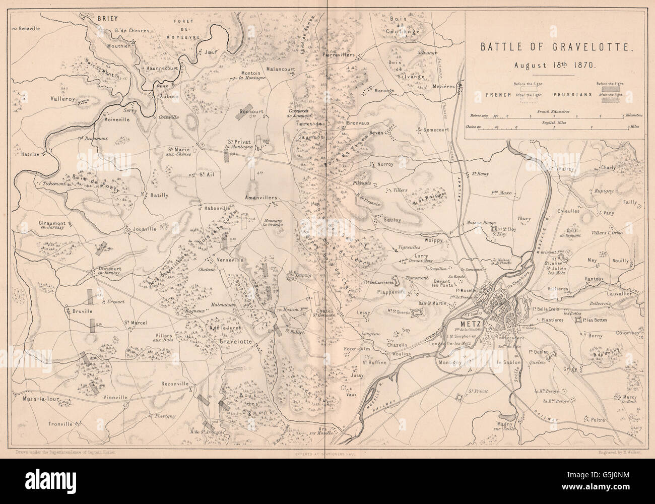 FRANCO-PRUSSIAN WAR: Battle of Gravelotte August 18 1870. Metz. Moselle 1875 map Stock Photohttps://www.alamy.com/image-license-details/?v=1https://www.alamy.com/stock-photo-franco-prussian-war-battle-of-gravelotte-august-18-1870-metz-moselle-106731232.html
RFG5J0NM–FRANCO-PRUSSIAN WAR: Battle of Gravelotte August 18 1870. Metz. Moselle 1875 map
 Map of Europe characterising the rival super powers after the Franco-Prussian war 1870 Stock Photohttps://www.alamy.com/image-license-details/?v=1https://www.alamy.com/stock-photo-map-of-europe-characterising-the-rival-super-powers-after-the-franco-84969237.html
RMEX6K3H–Map of Europe characterising the rival super powers after the Franco-Prussian war 1870
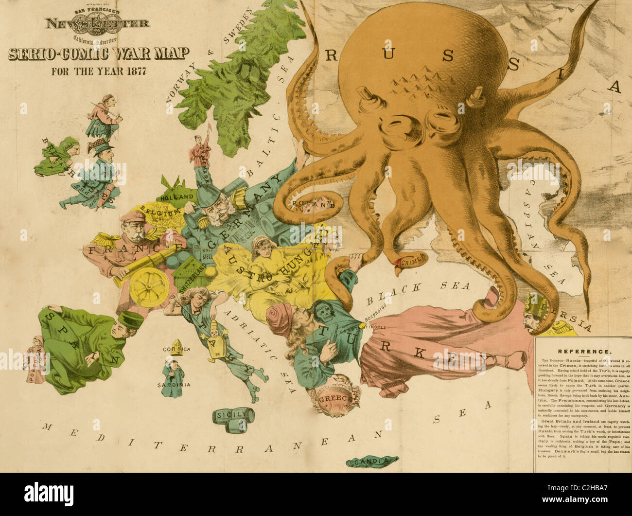 Serio-comic war map for the year 1877 Stock Photohttps://www.alamy.com/image-license-details/?v=1https://www.alamy.com/stock-photo-serio-comic-war-map-for-the-year-1877-36032143.html
RMC2HBA7–Serio-comic war map for the year 1877
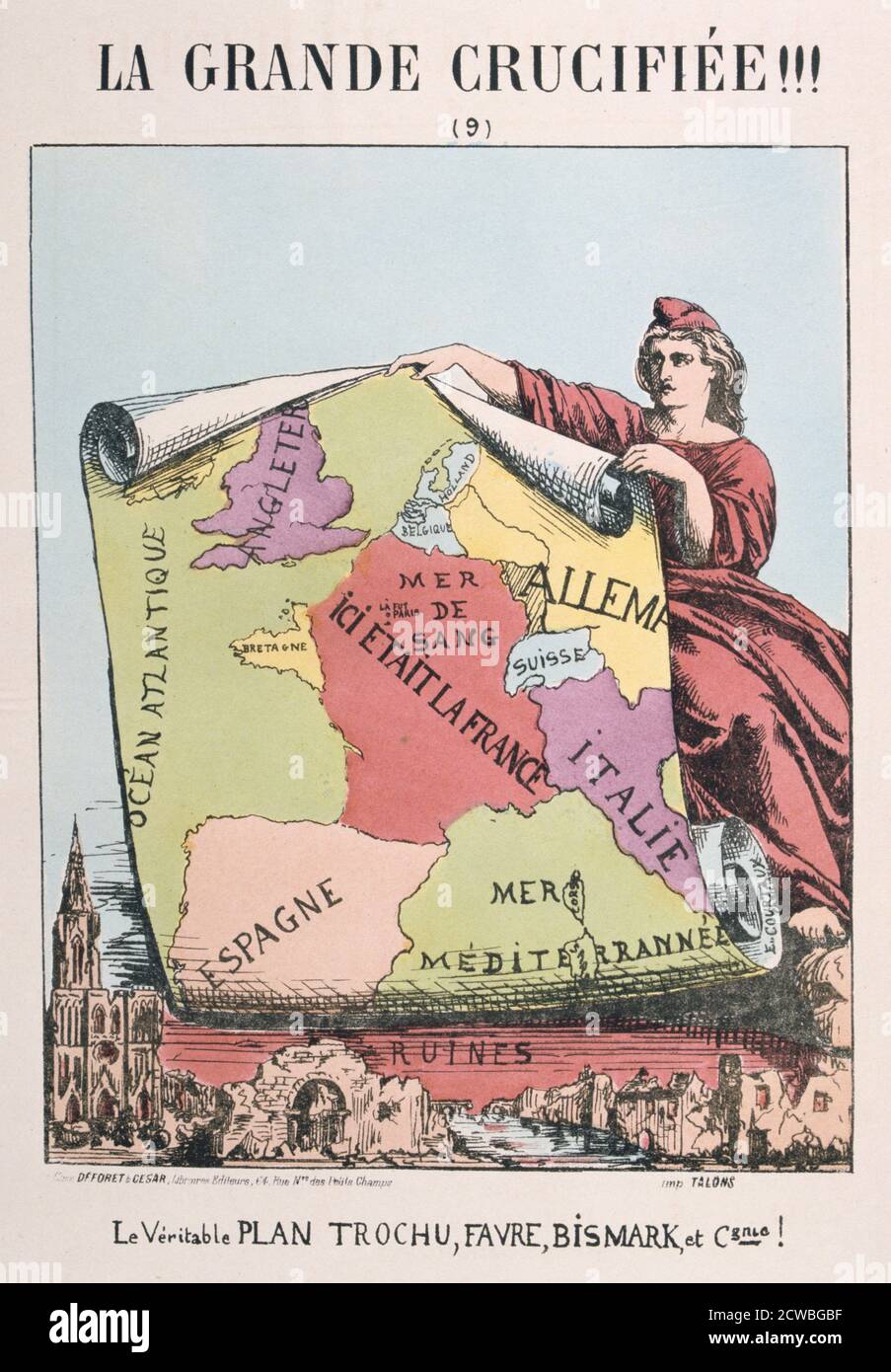 Allegory of Republican France, by E Courtaux, 1871. Cartoon from a series titled La Grande Crucifiee!!! depicting Marianne as Republican France. Here she holds up a map portraying France as a 'Mer de Sang' (sea of blood), as a result of the upheavals of the Franco-Prussian War and the Paris Commune. From a private collection. Stock Photohttps://www.alamy.com/image-license-details/?v=1https://www.alamy.com/allegory-of-republican-france-by-e-courtaux-1871-cartoon-from-a-series-titled-la-grande-crucifiee!!!-depicting-marianne-as-republican-france-here-she-holds-up-a-map-portraying-france-as-a-mer-de-sang-sea-of-blood-as-a-result-of-the-upheavals-of-the-franco-prussian-war-and-the-paris-commune-from-a-private-collection-image377038467.html
RM2CWBGBF–Allegory of Republican France, by E Courtaux, 1871. Cartoon from a series titled La Grande Crucifiee!!! depicting Marianne as Republican France. Here she holds up a map portraying France as a 'Mer de Sang' (sea of blood), as a result of the upheavals of the Franco-Prussian War and the Paris Commune. From a private collection.
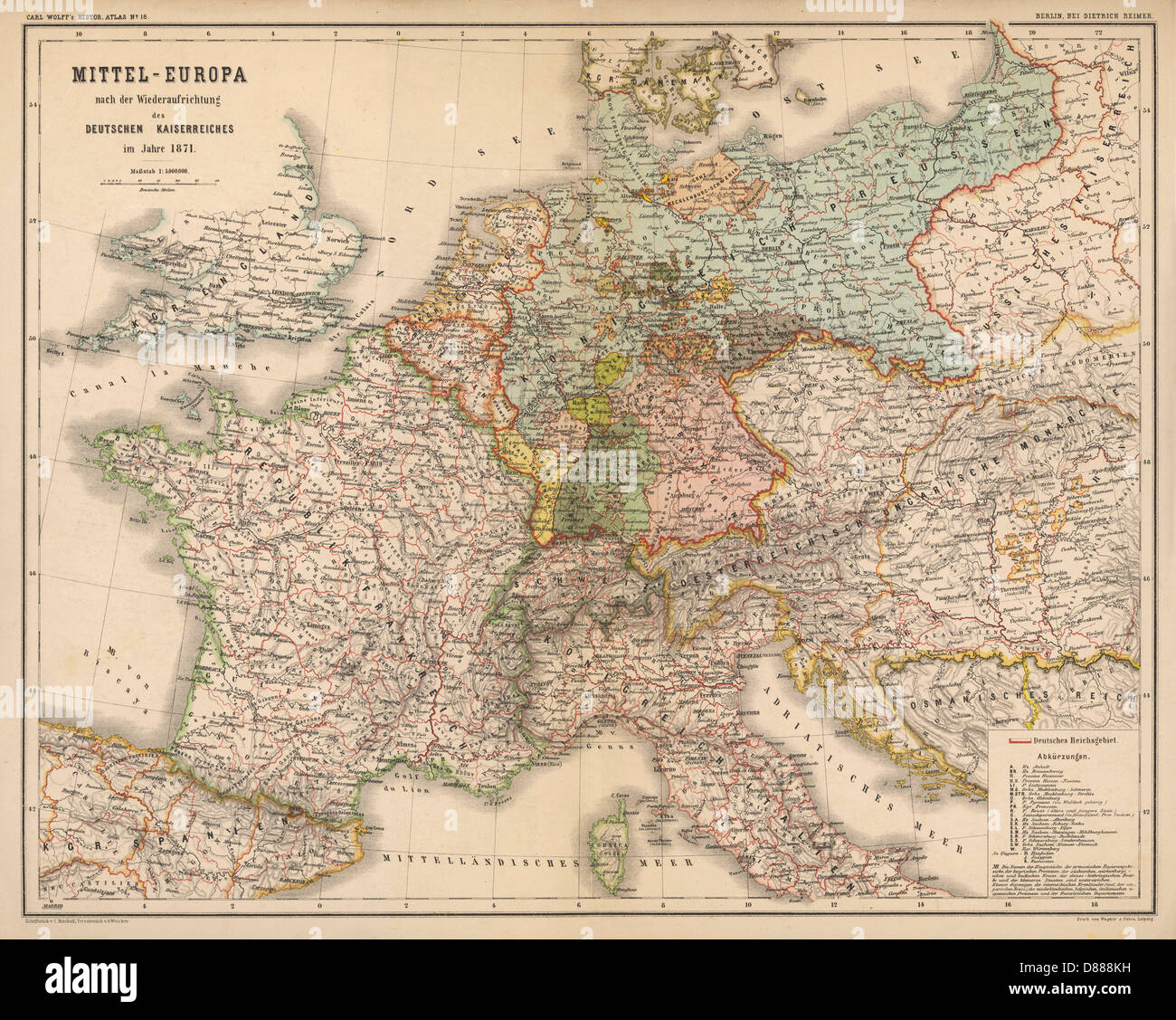 Map - Europe - Germany 1871 Stock Photohttps://www.alamy.com/image-license-details/?v=1https://www.alamy.com/stock-photo-map-europe-germany-1871-56730789.html
RMD888KH–Map - Europe - Germany 1871
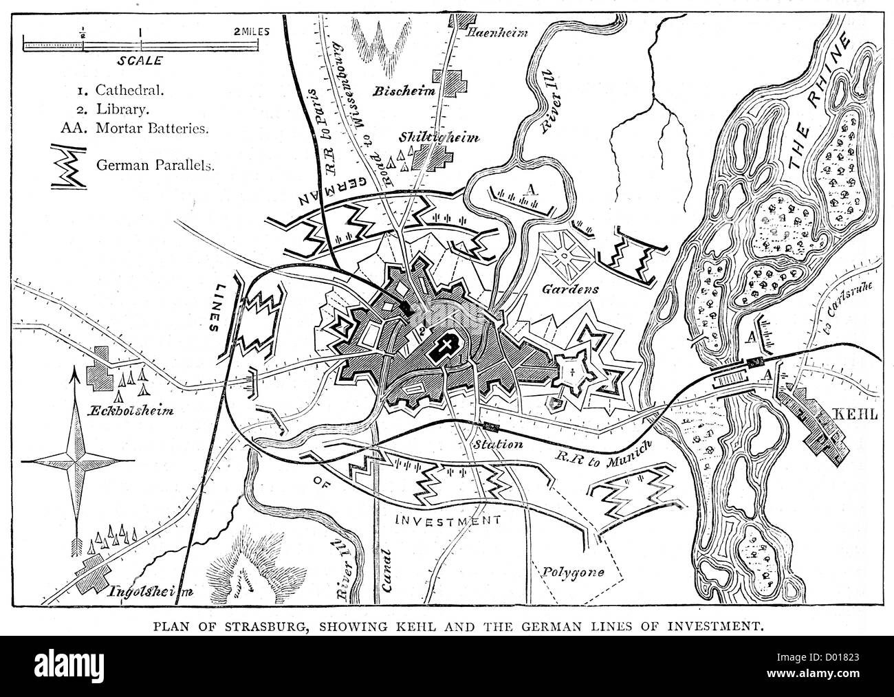 Map of the Siege of Strasbourg, which took place during the Franco-Prussian War Stock Photohttps://www.alamy.com/image-license-details/?v=1https://www.alamy.com/stock-photo-map-of-the-siege-of-strasbourg-which-took-place-during-the-franco-51659387.html
RMD01823–Map of the Siege of Strasbourg, which took place during the Franco-Prussian War
 FRANCO-PRUSSIAN WAR (1870-1871) Parisians check a map to follow the progress of the war Stock Photohttps://www.alamy.com/image-license-details/?v=1https://www.alamy.com/stock-photo-franco-prussian-war-1870-1871-parisians-check-a-map-to-follow-the-95163043.html
RMFER1C3–FRANCO-PRUSSIAN WAR (1870-1871) Parisians check a map to follow the progress of the war
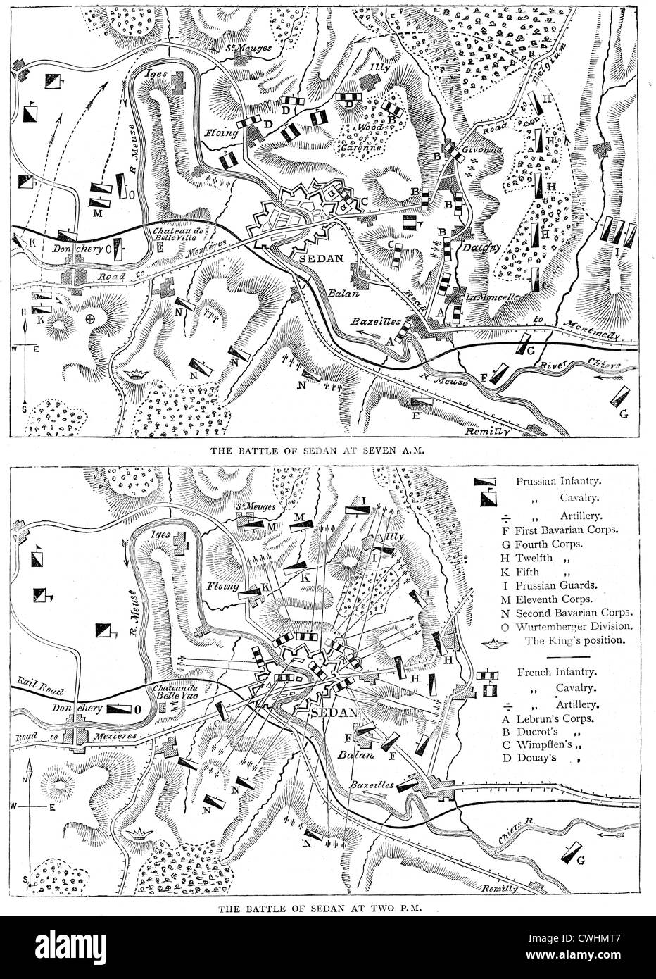 Maps of the Battle of Sedan, fought during the Franco-Prussian War on 1 September 1870. Stock Photohttps://www.alamy.com/image-license-details/?v=1https://www.alamy.com/stock-photo-maps-of-the-battle-of-sedan-fought-during-the-franco-prussian-war-50176679.html
RMCWHMT7–Maps of the Battle of Sedan, fought during the Franco-Prussian War on 1 September 1870.
 Franco-Prussian War: Map of Alsace and Lorraine, Counties Given to the German Empire 1870 Stock Photohttps://www.alamy.com/image-license-details/?v=1https://www.alamy.com/franco-prussian-war-map-of-alsace-and-lorraine-counties-given-to-the-german-empire-1870-image240632936.html
RMRYDNNC–Franco-Prussian War: Map of Alsace and Lorraine, Counties Given to the German Empire 1870
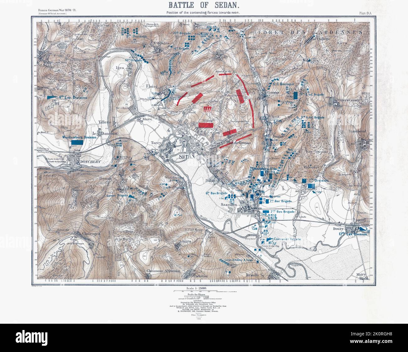 The Battle of Sedan 1 - 2 September 1870 during the Franco-Prussian War 1870 - 1871. Map of the disposition of forces at approximately midday 2 September 1870 only hours before the surounded French surrendered. After a map published in 1905. Stock Photohttps://www.alamy.com/image-license-details/?v=1https://www.alamy.com/the-battle-of-sedan-1-2-september-1870-during-the-franco-prussian-war-1870-1871-map-of-the-disposition-of-forces-at-approximately-midday-2-september-1870-only-hours-before-the-surounded-french-surrendered-after-a-map-published-in-1905-image482408228.html
RM2K0RGH8–The Battle of Sedan 1 - 2 September 1870 during the Franco-Prussian War 1870 - 1871. Map of the disposition of forces at approximately midday 2 September 1870 only hours before the surounded French surrendered. After a map published in 1905.
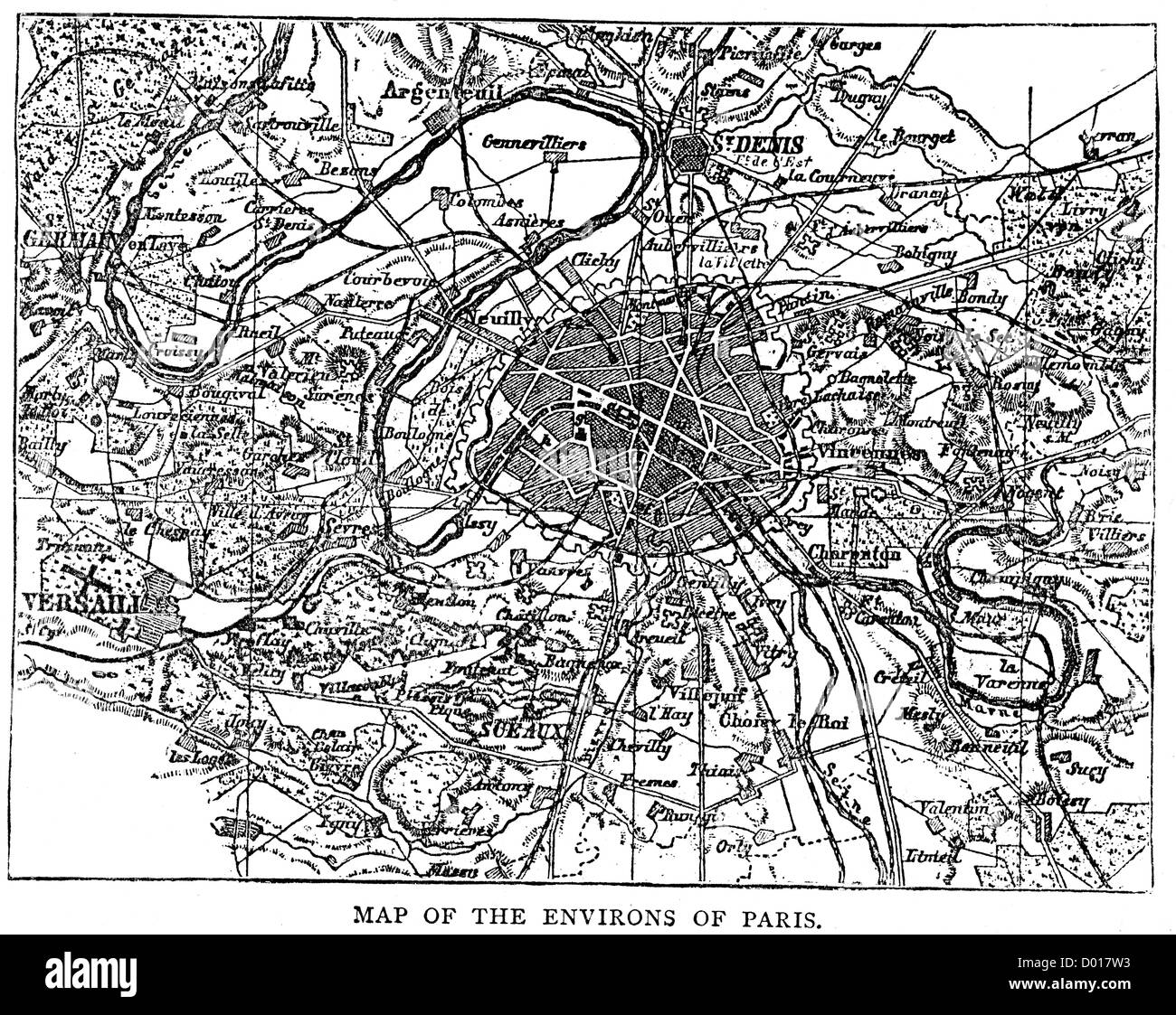 Map of the environs of Paris at the time of the Franco Prussian War Stock Photohttps://www.alamy.com/image-license-details/?v=1https://www.alamy.com/stock-photo-map-of-the-environs-of-paris-at-the-time-of-the-franco-prussian-war-51659247.html
RMD017W3–Map of the environs of Paris at the time of the Franco Prussian War
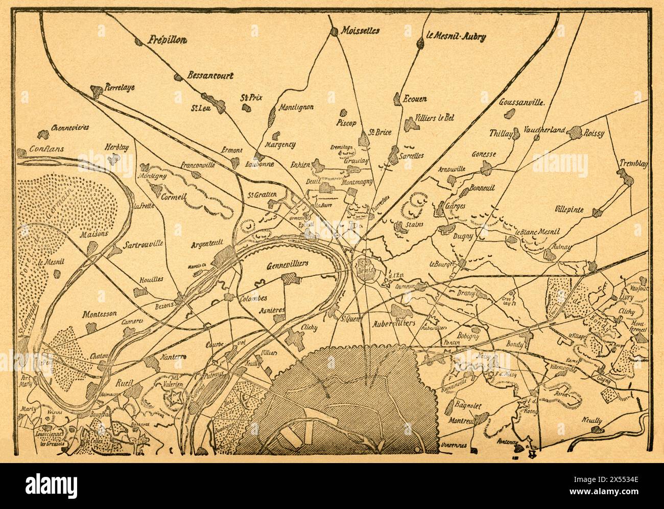 geography / travel, Germany, France, Franco-Prussian War, the closure on Paris, second part of the map, ARTIST'S COPYRIGHT HAS NOT TO BE CLEARED Stock Photohttps://www.alamy.com/image-license-details/?v=1https://www.alamy.com/geography-travel-germany-france-franco-prussian-war-the-closure-on-paris-second-part-of-the-map-artists-copyright-has-not-to-be-cleared-image605548398.html
RM2X5534E–geography / travel, Germany, France, Franco-Prussian War, the closure on Paris, second part of the map, ARTIST'S COPYRIGHT HAS NOT TO BE CLEARED
 Map of the Battle of Gravelotte fought on the 18 August 1870, it was a battle of the Franco-Prussian War Stock Photohttps://www.alamy.com/image-license-details/?v=1https://www.alamy.com/stock-photo-map-of-the-battle-of-gravelotte-fought-on-the-18-august-1870-it-was-50175451.html
RMCWHK8B–Map of the Battle of Gravelotte fought on the 18 August 1870, it was a battle of the Franco-Prussian War
 Franco-Prussian War (1870-1871). Armistice ceremony and capitulation of Paris, held on 28 January 1871 at the Palace of Versailles, between Jules Favre (1809-1880) and Otto von Bismarck (1815-1898). Favre undertook, on behalf of the French government, to hand over Alsace and Lorraine to Germany and to pay war reparations. Drawing by Miranda. Engraving by Capuz. 'Historia de la Guerra de Francia y Prusia' (History of the War between France and Prussia). Volume II. Published in Barcelona, 1871. Stock Photohttps://www.alamy.com/image-license-details/?v=1https://www.alamy.com/franco-prussian-war-1870-1871-armistice-ceremony-and-capitulation-of-paris-held-on-28-january-1871-at-the-palace-of-versailles-between-jules-favre-1809-1880-and-otto-von-bismarck-1815-1898-favre-undertook-on-behalf-of-the-french-government-to-hand-over-alsace-and-lorraine-to-germany-and-to-pay-war-reparations-drawing-by-miranda-engraving-by-capuz-historia-de-la-guerra-de-francia-y-prusia-history-of-the-war-between-france-and-prussia-volume-ii-published-in-barcelona-1871-image599869753.html
RM2WRXBYN–Franco-Prussian War (1870-1871). Armistice ceremony and capitulation of Paris, held on 28 January 1871 at the Palace of Versailles, between Jules Favre (1809-1880) and Otto von Bismarck (1815-1898). Favre undertook, on behalf of the French government, to hand over Alsace and Lorraine to Germany and to pay war reparations. Drawing by Miranda. Engraving by Capuz. 'Historia de la Guerra de Francia y Prusia' (History of the War between France and Prussia). Volume II. Published in Barcelona, 1871.
 Latest war map of Europe : as seen through French eyes. Hadol, Paul, 1835-1875. Franco-Prussian War, 1870-1871--Propaganda. L. Prang & Co. Stock Photohttps://www.alamy.com/image-license-details/?v=1https://www.alamy.com/latest-war-map-of-europe-as-seen-through-french-eyes-hadol-paul-1835-1875-franco-prussian-war-1870-1871-propaganda-l-prang-co-image444948066.html
RM2GRW3PA–Latest war map of Europe : as seen through French eyes. Hadol, Paul, 1835-1875. Franco-Prussian War, 1870-1871--Propaganda. L. Prang & Co.
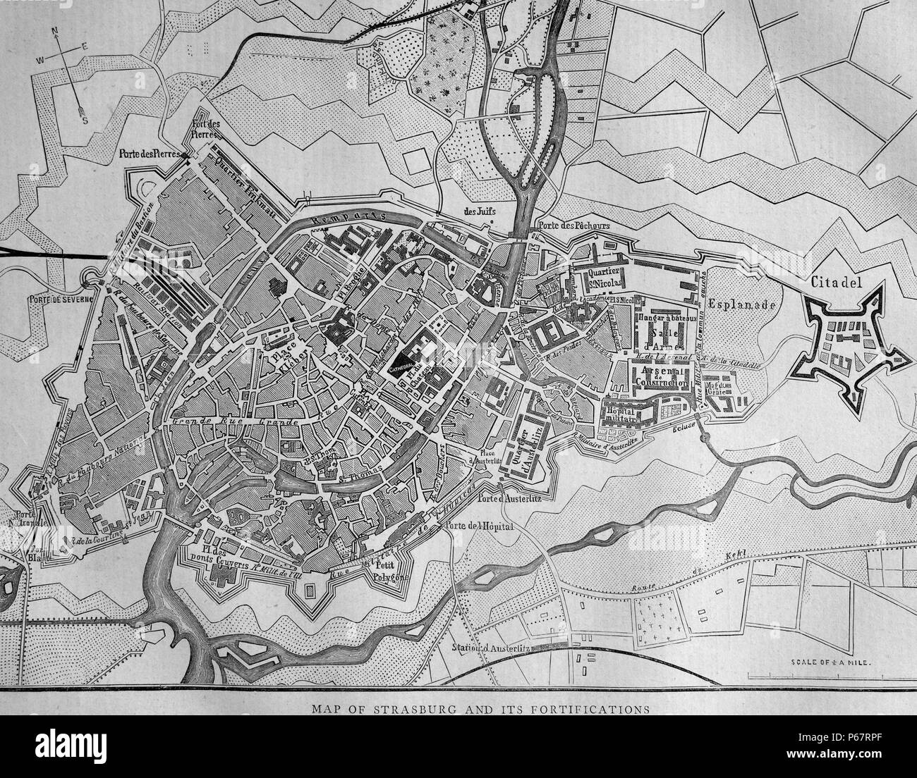 Map of Strasburg and it's fortifications. Strasburg is a town in the Vorpommern-Greifswald district of Mecklenburg-Vorpommern, Germany. Dated 1870 Stock Photohttps://www.alamy.com/image-license-details/?v=1https://www.alamy.com/map-of-strasburg-and-its-fortifications-strasburg-is-a-town-in-the-vorpommern-greifswald-district-of-mecklenburg-vorpommern-germany-dated-1870-image210384679.html
RMP67RPF–Map of Strasburg and it's fortifications. Strasburg is a town in the Vorpommern-Greifswald district of Mecklenburg-Vorpommern, Germany. Dated 1870
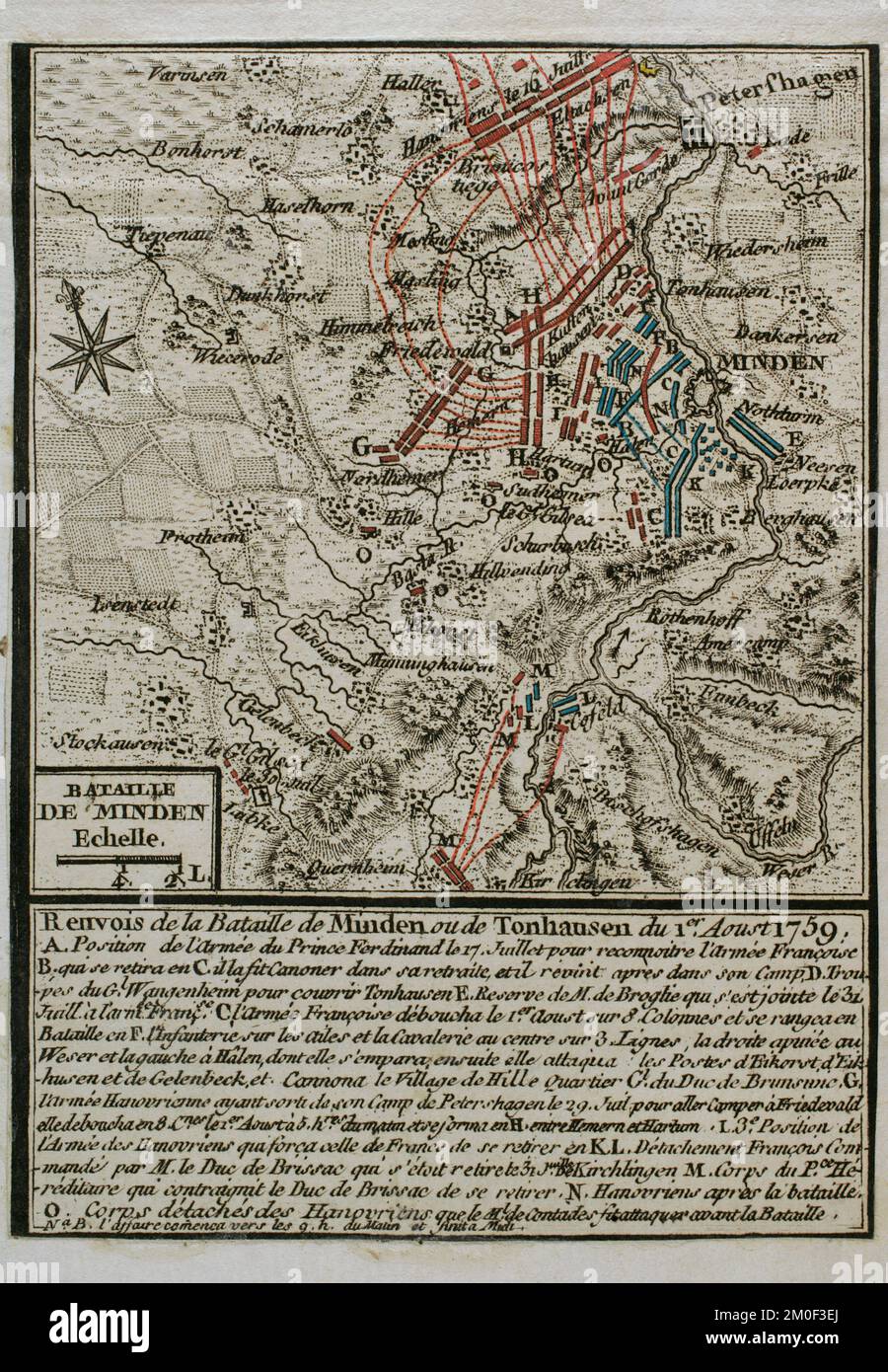 Seven Years War (1756-1763). Battle of Minden (1st August 1759). North Germany. The Anglo-Hanoverian army, led by Prince Ferdinand of Brunswick, defeated the French and Saxons troops. Map published in 1765 by the cartographer Jean de Beaurain (1696-1771) as an illustration of his Great Map of Germany, with the events that took place during the War of the Seven Years. Allied army in red and the French army in blue. Etching and engraving. French edition, 1765. Military Historical Library of Barcelona (Biblioteca Histórico Militar de Barcelona). Catalonia. Spain. Stock Photohttps://www.alamy.com/image-license-details/?v=1https://www.alamy.com/seven-years-war-1756-1763-battle-of-minden-1st-august-1759-north-germany-the-anglo-hanoverian-army-led-by-prince-ferdinand-of-brunswick-defeated-the-french-and-saxons-troops-map-published-in-1765-by-the-cartographer-jean-de-beaurain-1696-1771-as-an-illustration-of-his-great-map-of-germany-with-the-events-that-took-place-during-the-war-of-the-seven-years-allied-army-in-red-and-the-french-army-in-blue-etching-and-engraving-french-edition-1765-military-historical-library-of-barcelona-biblioteca-histrico-militar-de-barcelona-catalonia-spain-image499432714.html
RM2M0F3EJ–Seven Years War (1756-1763). Battle of Minden (1st August 1759). North Germany. The Anglo-Hanoverian army, led by Prince Ferdinand of Brunswick, defeated the French and Saxons troops. Map published in 1765 by the cartographer Jean de Beaurain (1696-1771) as an illustration of his Great Map of Germany, with the events that took place during the War of the Seven Years. Allied army in red and the French army in blue. Etching and engraving. French edition, 1765. Military Historical Library of Barcelona (Biblioteca Histórico Militar de Barcelona). Catalonia. Spain.
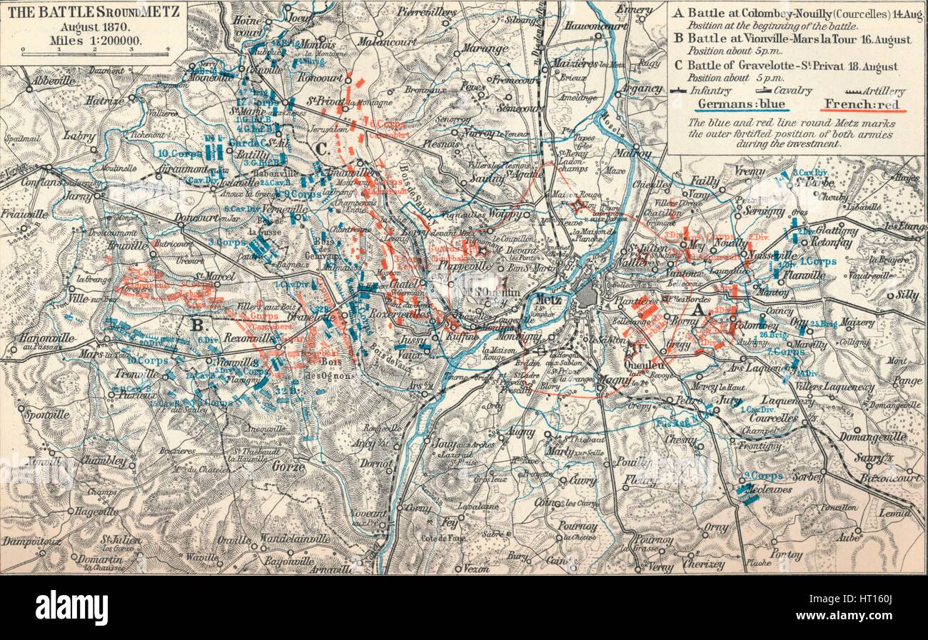 'The War of 1870-71. From the plans of the Prussian General Staff and other Sources', 1907. Artist: Unknown. Stock Photohttps://www.alamy.com/image-license-details/?v=1https://www.alamy.com/stock-photo-the-war-of-1870-71-from-the-plans-of-the-prussian-general-staff-and-135250994.html
RMHT160J–'The War of 1870-71. From the plans of the Prussian General Staff and other Sources', 1907. Artist: Unknown.
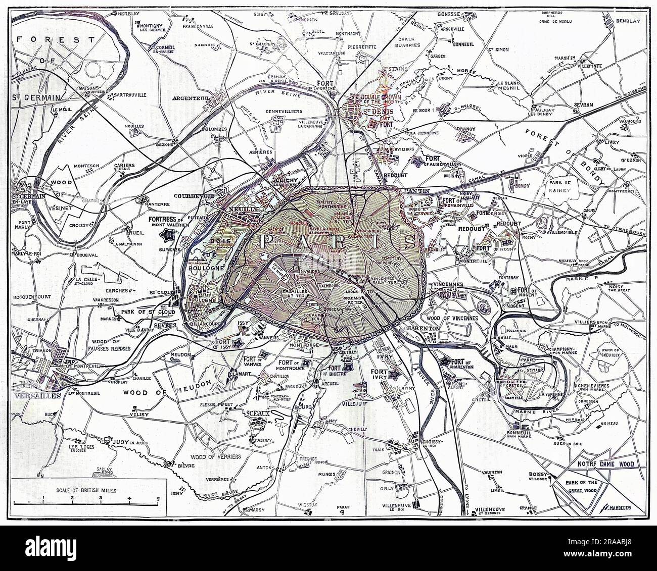 Map showing the fortifications in Paris during the Franco-Prussian War. Date: 1870 Stock Photohttps://www.alamy.com/image-license-details/?v=1https://www.alamy.com/map-showing-the-fortifications-in-paris-during-the-franco-prussian-war-date-1870-image557106992.html
RM2RAABJ8–Map showing the fortifications in Paris during the Franco-Prussian War. Date: 1870
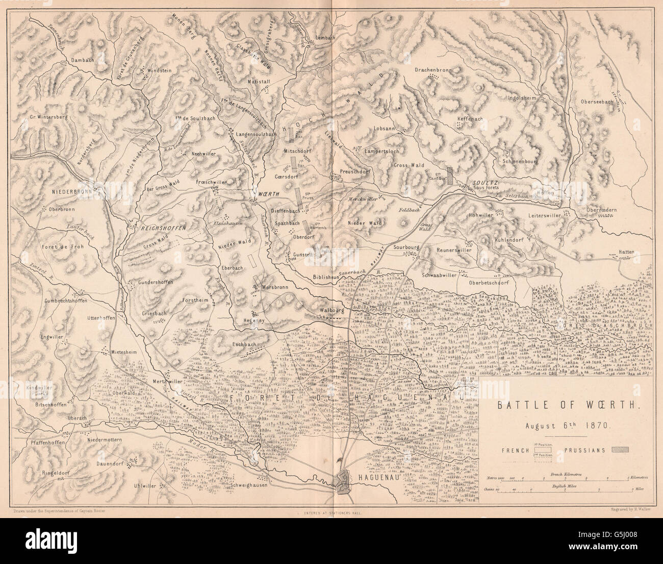 FRANCO-PRUSSIAN WAR: Battle of Woerth 1870. Haguenau Soultz Bas-Rhin, 1875 map Stock Photohttps://www.alamy.com/image-license-details/?v=1https://www.alamy.com/stock-photo-franco-prussian-war-battle-of-woerth-1870-haguenau-soultz-bas-rhin-106730632.html
RFG5J008–FRANCO-PRUSSIAN WAR: Battle of Woerth 1870. Haguenau Soultz Bas-Rhin, 1875 map
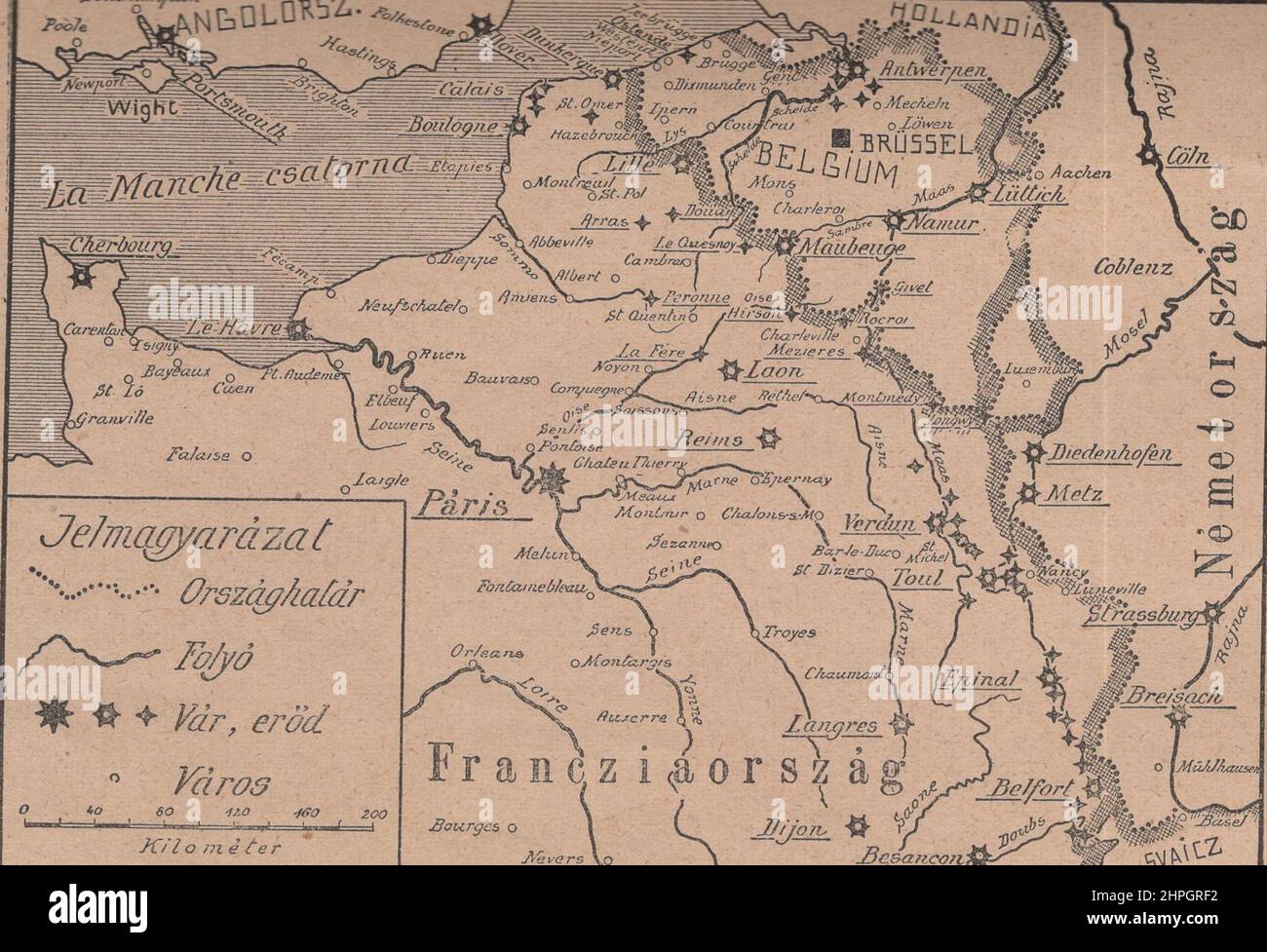 The theatre of the Franco-German-Belgian war, with its main fortresses and chain of border forts. map ADDITIONAL-RIGHTS-CLEARANCE-INFO-NOT-AVAILABLE AND EXPIRED. Stock Photohttps://www.alamy.com/image-license-details/?v=1https://www.alamy.com/the-theatre-of-the-franco-german-belgian-war-with-its-main-fortresses-and-chain-of-border-forts-map-additional-rights-clearance-info-not-available-and-expired-image461361686.html
RM2HPGRF2–The theatre of the Franco-German-Belgian war, with its main fortresses and chain of border forts. map ADDITIONAL-RIGHTS-CLEARANCE-INFO-NOT-AVAILABLE AND EXPIRED.
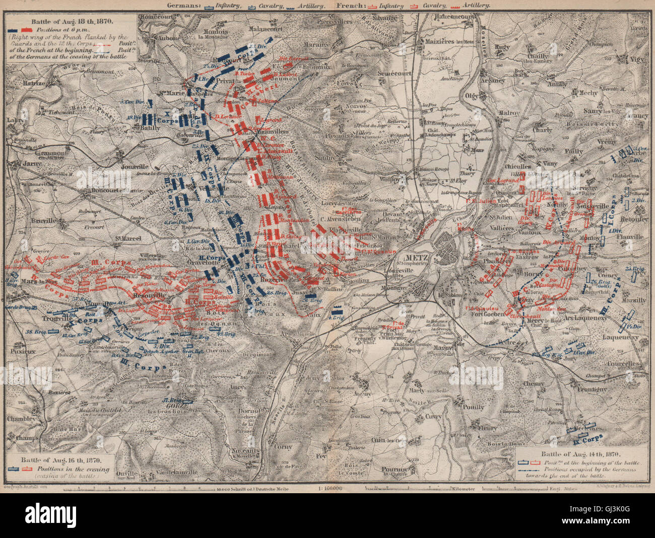 FRANCO-PRUSSIAN WAR. Battle of Mars-La-Tour Borny–Colombey 1870 Metz, 1892 map Stock Photohttps://www.alamy.com/image-license-details/?v=1https://www.alamy.com/stock-photo-franco-prussian-war-battle-of-mars-la-tour-bornycolombey-1870-metz-114406784.html
RFGJ3K0G–FRANCO-PRUSSIAN WAR. Battle of Mars-La-Tour Borny–Colombey 1870 Metz, 1892 map
 Europa, Deutschland, Frankreich, Deutsch-Französischer Krieg, Schlacht bei Colombey - Nouilly , Motiv aus : Der Krieg zwischen Frankreich und Deutschland in den Jahren 1870-1871 ' , von J. Scheibert, Verlag von W. Pauli´s Nachfolger ( H. Jerosch ) , Berlin , 1895 . / Europe, Germany, France, Franco-Prussian War, battle of Colombey - Nouilly , image from : ' Der Krieg zwischen Frankreich und Deutschland in den Jahren 1870-1871 ' ( the war between France and Prussian 1870-1871 ) , by J. Scheibert, publishing house W. Pauli´s successsor ( H. Jerosch ) , Berlin, 1895 . Stock Photohttps://www.alamy.com/image-license-details/?v=1https://www.alamy.com/europa-deutschland-frankreich-deutsch-franzsischer-krieg-schlacht-bei-colombey-nouilly-motiv-aus-der-krieg-zwischen-frankreich-und-deutschland-in-den-jahren-1870-1871-von-j-scheibert-verlag-von-w-paulis-nachfolger-h-jerosch-berlin-1895-europe-germany-france-franco-prussian-war-battle-of-colombey-nouilly-image-from-der-krieg-zwischen-frankreich-und-deutschland-in-den-jahren-1870-1871-the-war-between-france-and-prussian-1870-1871-by-j-scheibert-publishing-house-w-paulis-successsor-h-jerosch-berlin-1895-image359949802.html
RM2BWH3J2–Europa, Deutschland, Frankreich, Deutsch-Französischer Krieg, Schlacht bei Colombey - Nouilly , Motiv aus : Der Krieg zwischen Frankreich und Deutschland in den Jahren 1870-1871 ' , von J. Scheibert, Verlag von W. Pauli´s Nachfolger ( H. Jerosch ) , Berlin , 1895 . / Europe, Germany, France, Franco-Prussian War, battle of Colombey - Nouilly , image from : ' Der Krieg zwischen Frankreich und Deutschland in den Jahren 1870-1871 ' ( the war between France and Prussian 1870-1871 ) , by J. Scheibert, publishing house W. Pauli´s successsor ( H. Jerosch ) , Berlin, 1895 .
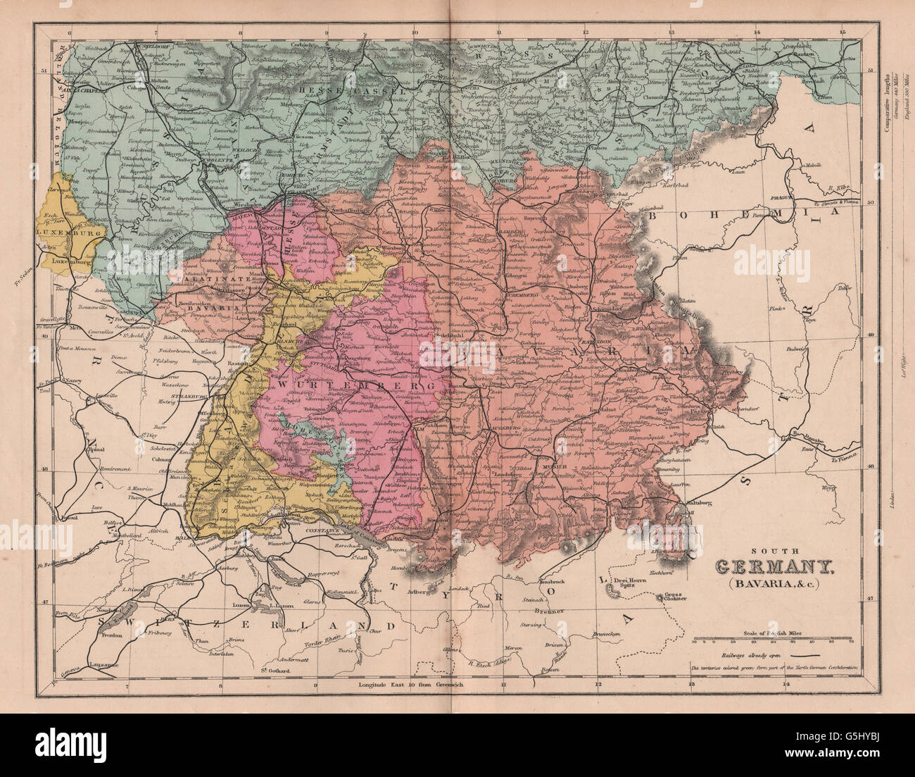 SOUTHERN GERMANY: Bavaria Wurttemberg Hesse Baden. Franco-Prussian War, 1875 map Stock Photohttps://www.alamy.com/image-license-details/?v=1https://www.alamy.com/stock-photo-southern-germany-bavaria-wurttemberg-hesse-baden-franco-prussian-war-106730166.html
RFG5HYBJ–SOUTHERN GERMANY: Bavaria Wurttemberg Hesse Baden. Franco-Prussian War, 1875 map
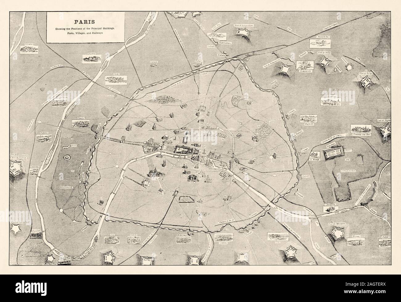 Overview of Paris in 1870, of its main monuments of the line of enciente and its external forts. The siege of Paris is an episode of the Franco-German Stock Photohttps://www.alamy.com/image-license-details/?v=1https://www.alamy.com/overview-of-paris-in-1870-of-its-main-monuments-of-the-line-of-enciente-and-its-external-forts-the-siege-of-paris-is-an-episode-of-the-franco-german-image337369982.html
RM2AGTERX–Overview of Paris in 1870, of its main monuments of the line of enciente and its external forts. The siege of Paris is an episode of the Franco-German
![Map of France, c1872. Showing the départements or provinces, including the island of Corsica, (inset bottom right). From "The Franco-Prussian War: its causes, incidents and consequences", Volume I, by Captain H M Hozier. [William Mackenzie, London, 1872] Stock Photo Map of France, c1872. Showing the départements or provinces, including the island of Corsica, (inset bottom right). From "The Franco-Prussian War: its causes, incidents and consequences", Volume I, by Captain H M Hozier. [William Mackenzie, London, 1872] Stock Photo](https://c8.alamy.com/comp/2AG0G34/map-of-france-c1872-showing-the-dxe9partements-or-provinces-including-the-island-of-corsica-inset-bottom-right-from-quotthe-franco-prussian-war-its-causes-incidents-and-consequencesquot-volume-i-by-captain-h-m-hozier-william-mackenzie-london-1872-2AG0G34.jpg) Map of France, c1872. Showing the départements or provinces, including the island of Corsica, (inset bottom right). From "The Franco-Prussian War: its causes, incidents and consequences", Volume I, by Captain H M Hozier. [William Mackenzie, London, 1872] Stock Photohttps://www.alamy.com/image-license-details/?v=1https://www.alamy.com/map-of-france-c1872-showing-the-dxe9partements-or-provinces-including-the-island-of-corsica-inset-bottom-right-from-quotthe-franco-prussian-war-its-causes-incidents-and-consequencesquot-volume-i-by-captain-h-m-hozier-william-mackenzie-london-1872-image336844120.html
Map of France, c1872. Showing the départements or provinces, including the island of Corsica, (inset bottom right). From "The Franco-Prussian War: its causes, incidents and consequences", Volume I, by Captain H M Hozier. [William Mackenzie, London, 1872] Stock Photohttps://www.alamy.com/image-license-details/?v=1https://www.alamy.com/map-of-france-c1872-showing-the-dxe9partements-or-provinces-including-the-island-of-corsica-inset-bottom-right-from-quotthe-franco-prussian-war-its-causes-incidents-and-consequencesquot-volume-i-by-captain-h-m-hozier-william-mackenzie-london-1872-image336844120.htmlRM2AG0G34–Map of France, c1872. Showing the départements or provinces, including the island of Corsica, (inset bottom right). From "The Franco-Prussian War: its causes, incidents and consequences", Volume I, by Captain H M Hozier. [William Mackenzie, London, 1872]
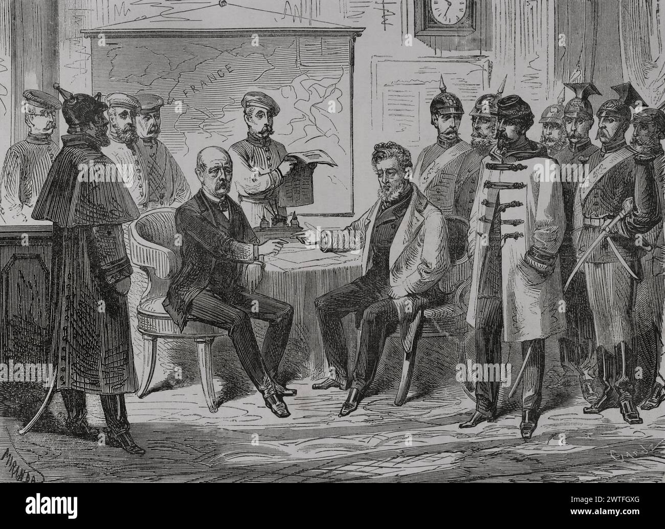 Franco-Prussian War (1870-1871). Armistice ceremony and capitulation of Paris, held on 28 January 1871 at the Palace of Versailles, between Jules Favre (1809-1880) and Otto von Bismarck (1815-1898). Favre undertook, on behalf of the French government, to hand over Alsace and Lorraine to Germany and to pay war reparations. Drawing by Miranda. Engraving by Capuz. 'Historia de la Guerra de Francia y Prusia' (History of the War between France and Prussia). Volume II. Published in Barcelona, 1871. Author: Fernando Miranda. 19th-century Spanish draughtsman. Tomás Carlos Capuz (1834-1899). Spanish en Stock Photohttps://www.alamy.com/image-license-details/?v=1https://www.alamy.com/franco-prussian-war-1870-1871-armistice-ceremony-and-capitulation-of-paris-held-on-28-january-1871-at-the-palace-of-versailles-between-jules-favre-1809-1880-and-otto-von-bismarck-1815-1898-favre-undertook-on-behalf-of-the-french-government-to-hand-over-alsace-and-lorraine-to-germany-and-to-pay-war-reparations-drawing-by-miranda-engraving-by-capuz-historia-de-la-guerra-de-francia-y-prusia-history-of-the-war-between-france-and-prussia-volume-ii-published-in-barcelona-1871-author-fernando-miranda-19th-century-spanish-draughtsman-toms-carlos-capuz-1834-1899-spanish-en-image600246824.html
RM2WTFGXG–Franco-Prussian War (1870-1871). Armistice ceremony and capitulation of Paris, held on 28 January 1871 at the Palace of Versailles, between Jules Favre (1809-1880) and Otto von Bismarck (1815-1898). Favre undertook, on behalf of the French government, to hand over Alsace and Lorraine to Germany and to pay war reparations. Drawing by Miranda. Engraving by Capuz. 'Historia de la Guerra de Francia y Prusia' (History of the War between France and Prussia). Volume II. Published in Barcelona, 1871. Author: Fernando Miranda. 19th-century Spanish draughtsman. Tomás Carlos Capuz (1834-1899). Spanish en
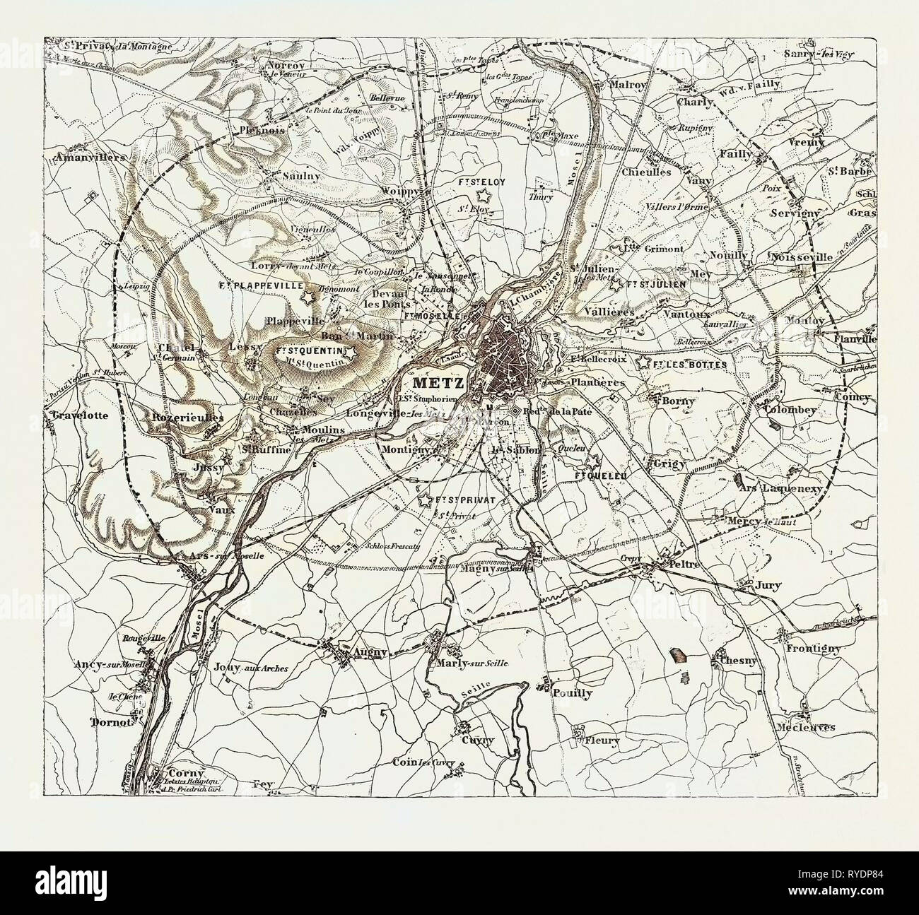 Franco-Prussian War: Map of Vicinity of Metz, Indicating the Position Occupied by the Besieging Army 1870 Stock Photohttps://www.alamy.com/image-license-details/?v=1https://www.alamy.com/franco-prussian-war-map-of-vicinity-of-metz-indicating-the-position-occupied-by-the-besieging-army-1870-image240633348.html
RMRYDP84–Franco-Prussian War: Map of Vicinity of Metz, Indicating the Position Occupied by the Besieging Army 1870
 . Deutsch: Karte Schlacht von Weißenburg im Deutsch-Französischen Krieg am 4. August 1870. English: German map of the Battle of Wissembourg in the Franco-Prussian War on August 4th, 1870. 76 Battle of wissembourg Stock Photohttps://www.alamy.com/image-license-details/?v=1https://www.alamy.com/deutsch-karte-schlacht-von-weienburg-im-deutsch-franzsischen-krieg-am-4-august-1870-english-german-map-of-the-battle-of-wissembourg-in-the-franco-prussian-war-on-august-4th-1870-76-battle-of-wissembourg-image184859153.html
RMMMN1MH–. Deutsch: Karte Schlacht von Weißenburg im Deutsch-Französischen Krieg am 4. August 1870. English: German map of the Battle of Wissembourg in the Franco-Prussian War on August 4th, 1870. 76 Battle of wissembourg
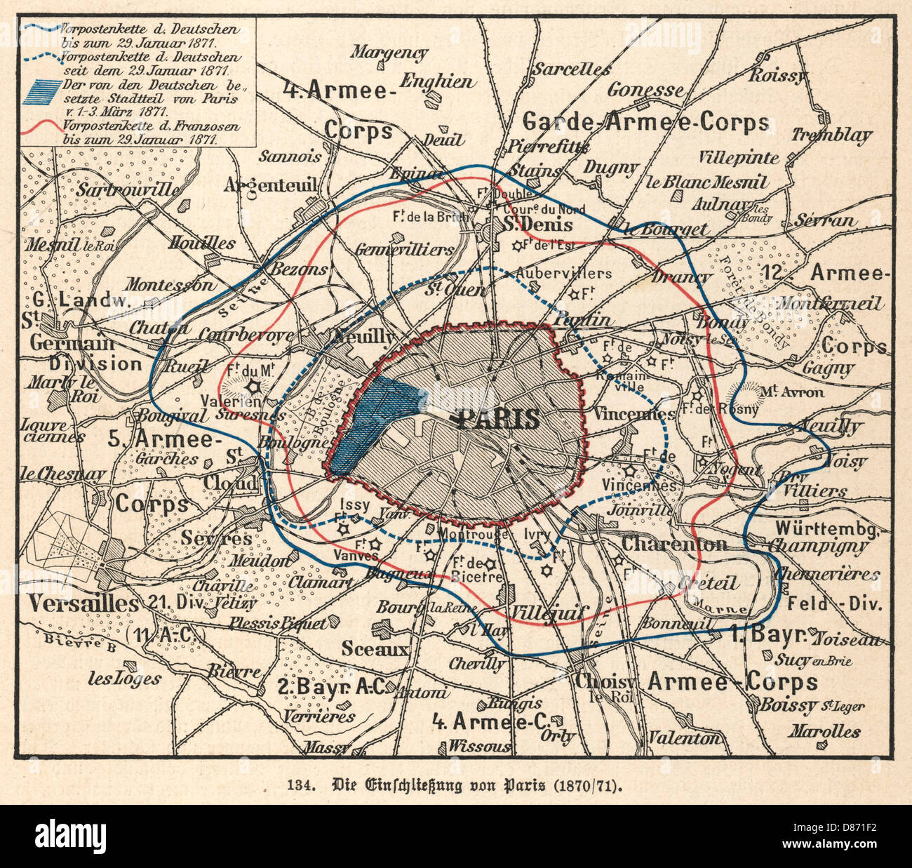 SIEGE OF PARIS MAP 1870 Stock Photohttps://www.alamy.com/image-license-details/?v=1https://www.alamy.com/stock-photo-siege-of-paris-map-1870-56703222.html
RMD871F2–SIEGE OF PARIS MAP 1870
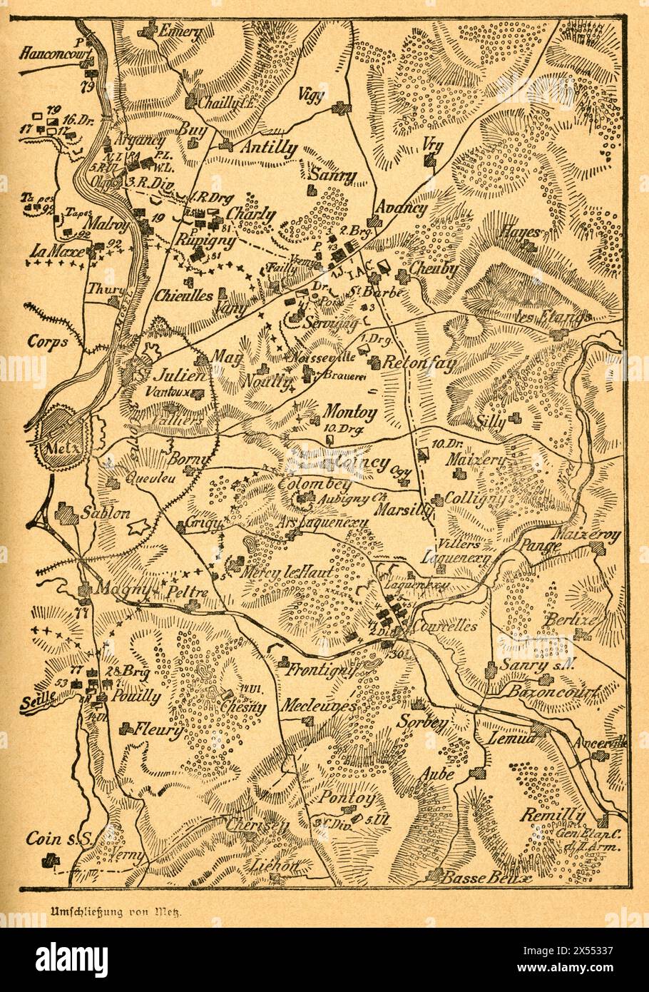 geography / travel, Germany, France, Metz, Franco-Prussian War, the closure on Metz, first part of the map, ARTIST'S COPYRIGHT HAS NOT TO BE CLEARED Stock Photohttps://www.alamy.com/image-license-details/?v=1https://www.alamy.com/geography-travel-germany-france-metz-franco-prussian-war-the-closure-on-metz-first-part-of-the-map-artists-copyright-has-not-to-be-cleared-image605548363.html
RM2X55337–geography / travel, Germany, France, Metz, Franco-Prussian War, the closure on Metz, first part of the map, ARTIST'S COPYRIGHT HAS NOT TO BE CLEARED
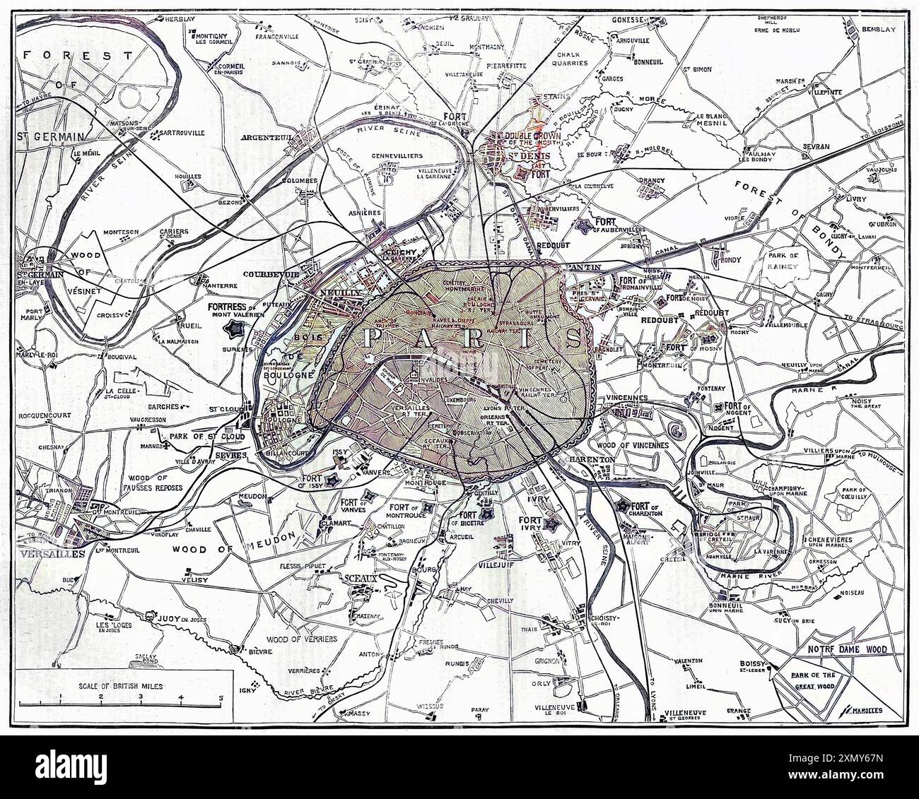 The War: Fortifications in Paris Stock Photohttps://www.alamy.com/image-license-details/?v=1https://www.alamy.com/the-war-fortifications-in-paris-image615253625.html
RM2XMY67N–The War: Fortifications in Paris
 Vintage Historical Satirical Map of Europe in 1899: An elaborate satirical map reflecting the European situation following the Franco-Prussian war. France had suffered a crushing defeat: the loss of Alsace and much of Lorraine. by Fred W. Rose Stock Photohttps://www.alamy.com/image-license-details/?v=1https://www.alamy.com/vintage-historical-satirical-map-of-europe-in-1899-an-elaborate-satirical-map-reflecting-the-european-situation-following-the-franco-prussian-war-france-had-suffered-a-crushing-defeat-the-loss-of-alsace-and-much-of-lorraine-by-fred-w-rose-image625328519.html
RM2Y9A4WB–Vintage Historical Satirical Map of Europe in 1899: An elaborate satirical map reflecting the European situation following the Franco-Prussian war. France had suffered a crushing defeat: the loss of Alsace and much of Lorraine. by Fred W. Rose
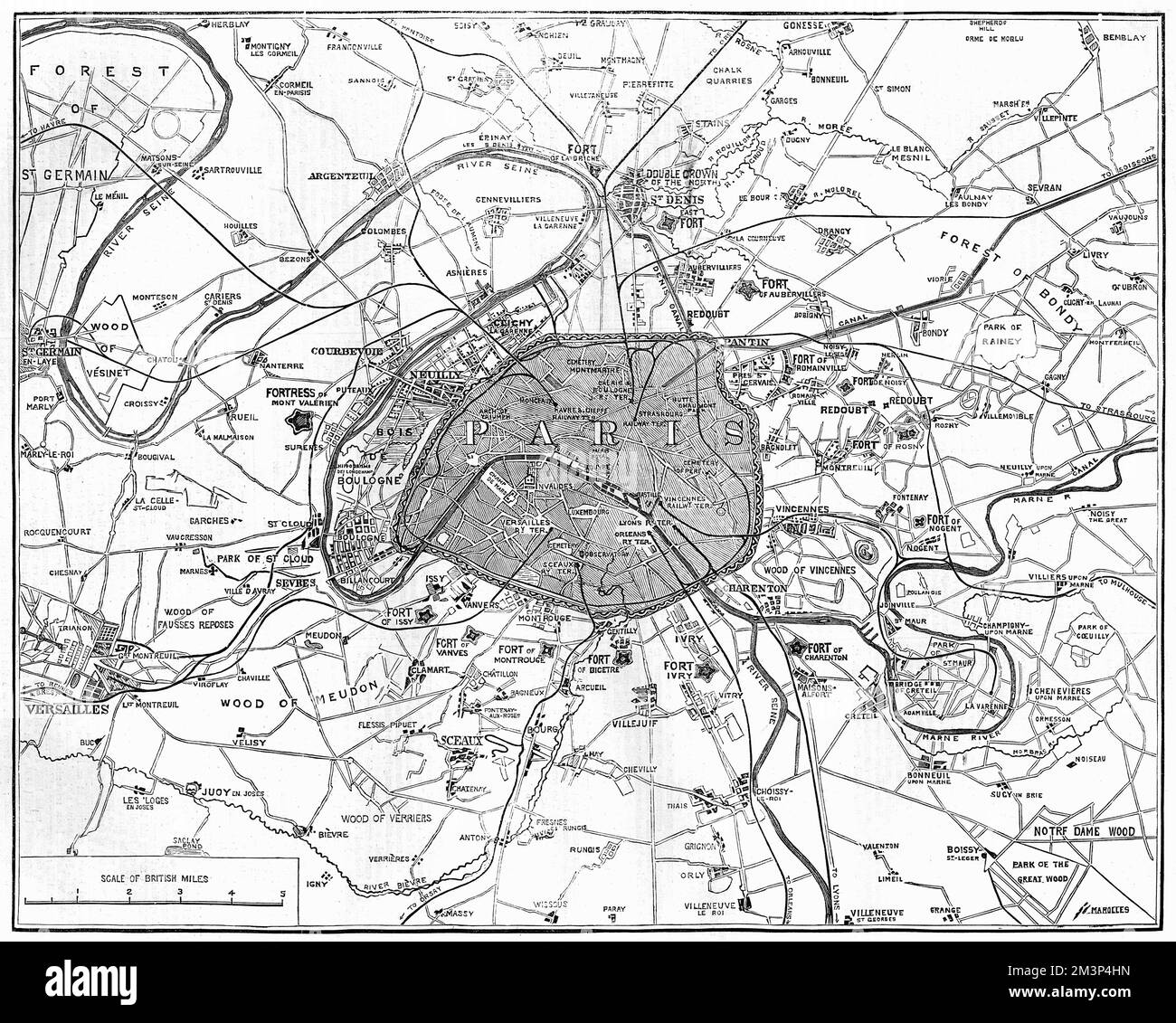 The War: Fortifications in Paris Stock Photohttps://www.alamy.com/image-license-details/?v=1https://www.alamy.com/the-war-fortifications-in-paris-image501431217.html
RM2M3P4HN–The War: Fortifications in Paris
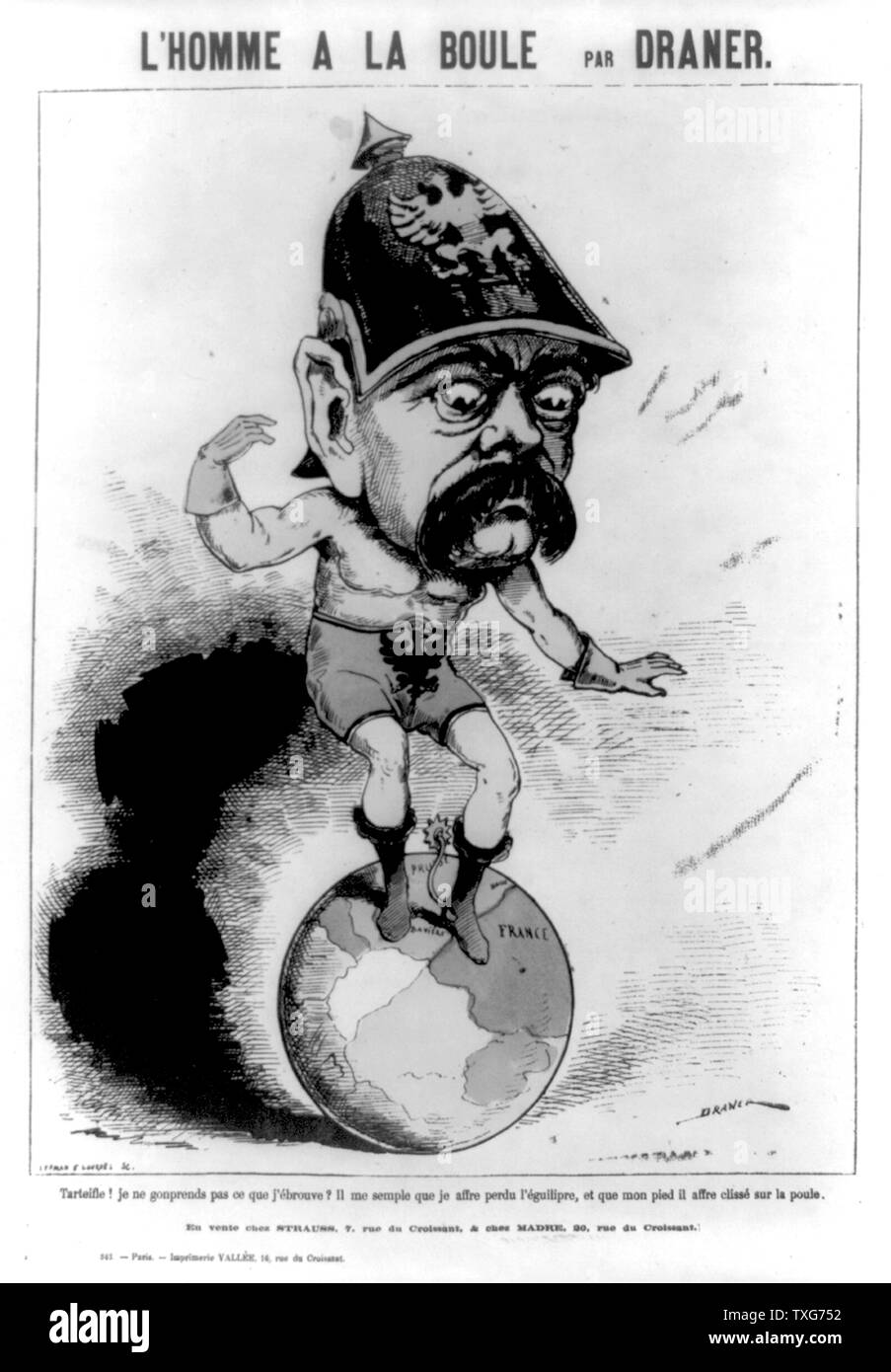 The Man on the Ball : Cartoon of Otto von Bismarck, Prussian statesman, having difficulty balancing on the world - his left foot is on France French cartoon published during the Franco-Prussian War (1870-1871) Stock Photohttps://www.alamy.com/image-license-details/?v=1https://www.alamy.com/the-man-on-the-ball-cartoon-of-otto-von-bismarck-prussian-statesman-having-difficulty-balancing-on-the-world-his-left-foot-is-on-france-french-cartoon-published-during-the-franco-prussian-war-1870-1871-image257283070.html
RMTXG752–The Man on the Ball : Cartoon of Otto von Bismarck, Prussian statesman, having difficulty balancing on the world - his left foot is on France French cartoon published during the Franco-Prussian War (1870-1871)
 Serio-comic war map for the year 1877 Stock Photohttps://www.alamy.com/image-license-details/?v=1https://www.alamy.com/serio-comic-war-map-for-the-year-1877-image370864881.html
RM2CFA9X9–Serio-comic war map for the year 1877
![Image taken from page 140 of '[Cassell's Illustrated History of the War between France and Germany, 1870-1871.]' Image taken from page 140 of '[Cassell's Illustrated History of Stock Photo Image taken from page 140 of '[Cassell's Illustrated History of the War between France and Germany, 1870-1871.]' Image taken from page 140 of '[Cassell's Illustrated History of Stock Photo](https://c8.alamy.com/comp/HBTBXE/image-taken-from-page-140-of-cassells-illustrated-history-of-the-war-HBTBXE.jpg) Image taken from page 140 of '[Cassell's Illustrated History of the War between France and Germany, 1870-1871.]' Image taken from page 140 of '[Cassell's Illustrated History of Stock Photohttps://www.alamy.com/image-license-details/?v=1https://www.alamy.com/stock-photo-image-taken-from-page-140-of-cassells-illustrated-history-of-the-war-127770006.html
Image taken from page 140 of '[Cassell's Illustrated History of the War between France and Germany, 1870-1871.]' Image taken from page 140 of '[Cassell's Illustrated History of Stock Photohttps://www.alamy.com/image-license-details/?v=1https://www.alamy.com/stock-photo-image-taken-from-page-140-of-cassells-illustrated-history-of-the-war-127770006.htmlRMHBTBXE–Image taken from page 140 of '[Cassell's Illustrated History of the War between France and Germany, 1870-1871.]' Image taken from page 140 of '[Cassell's Illustrated History of
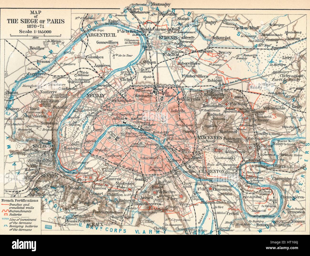 'Map of The Siege of Paris, 1870-71', 1907. Artist: Unknown. Stock Photohttps://www.alamy.com/image-license-details/?v=1https://www.alamy.com/stock-photo-map-of-the-siege-of-paris-1870-71-1907-artist-unknown-135251162.html
RMHT166J–'Map of The Siege of Paris, 1870-71', 1907. Artist: Unknown.
 Map of Strasburg and it's fortifications. Strasburg is a town in the Vorpommern-Greifswald district of Mecklenburg-Vorpommern, Germany. Dated 1870 Stock Photohttps://www.alamy.com/image-license-details/?v=1https://www.alamy.com/stock-photo-map-of-strasburg-and-its-fortifications-strasburg-is-a-town-in-the-76388199.html
RMEC7NWY–Map of Strasburg and it's fortifications. Strasburg is a town in the Vorpommern-Greifswald district of Mecklenburg-Vorpommern, Germany. Dated 1870
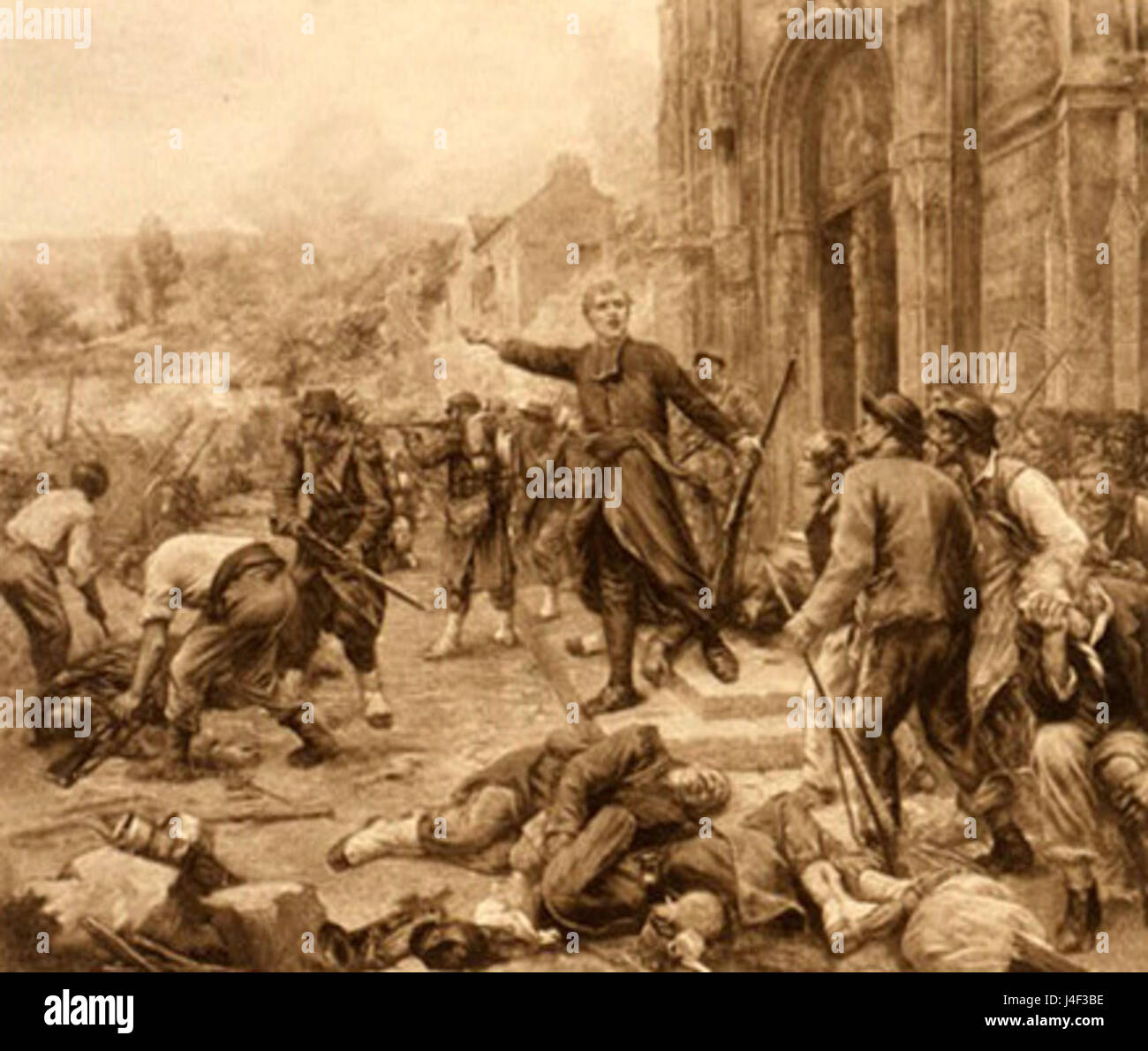 Franco Prussian War Bazelles France Stock Photohttps://www.alamy.com/image-license-details/?v=1https://www.alamy.com/stock-photo-franco-prussian-war-bazelles-france-140473522.html
RMJ4F3BE–Franco Prussian War Bazelles France
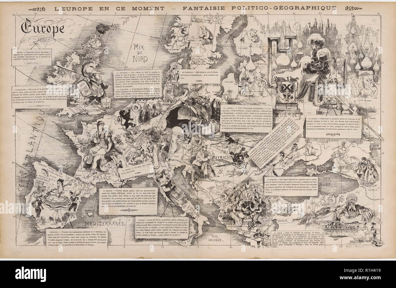 map reflecting the European situation following the Franco-Prussian war Stock Photohttps://www.alamy.com/image-license-details/?v=1https://www.alamy.com/map-reflecting-the-european-situation-following-the-franco-prussian-war-image224725797.html
RMR1H419–map reflecting the European situation following the Franco-Prussian war
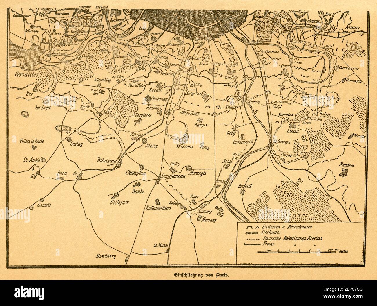 Europa, Deutschland, Frankreich, Deutsch-Französischer Krieg, Paris, Einschließung von Paris, erster Teil der Karte, Motiv aus : Der Krieg zwischen Frankreich und Deutschland in den Jahren 1870-1871 ' , von J. Scheibert, Verlag von W. Pauli´s Nachfolger ( H. Jerosch ) , Berlin , 1895 . / Europe, Germany, France, Paris, Franco-Prussian War, the closure on Paris, first part of the map, image from : ' Der Krieg zwischen Frankreich und Deutschland in den Jahren 1870-1871 ' ( the war between France and Prussian 1870-1871 ) , by J. Scheibert, publishing house W. Pauli´s successsor ( H. Jerosch ) Stock Photohttps://www.alamy.com/image-license-details/?v=1https://www.alamy.com/europa-deutschland-frankreich-deutsch-franzsischer-krieg-paris-einschlieung-von-paris-erster-teil-der-karte-motiv-aus-der-krieg-zwischen-frankreich-und-deutschland-in-den-jahren-1870-1871-von-j-scheibert-verlag-von-w-paulis-nachfolger-h-jerosch-berlin-1895-europe-germany-france-paris-franco-prussian-war-the-closure-on-paris-first-part-of-the-map-image-from-der-krieg-zwischen-frankreich-und-deutschland-in-den-jahren-1870-1871-the-war-between-france-and-prussian-1870-1871-by-j-scheibert-publishing-house-w-paulis-successsor-h-jerosch-image358014848.html
RM2BPCYGG–Europa, Deutschland, Frankreich, Deutsch-Französischer Krieg, Paris, Einschließung von Paris, erster Teil der Karte, Motiv aus : Der Krieg zwischen Frankreich und Deutschland in den Jahren 1870-1871 ' , von J. Scheibert, Verlag von W. Pauli´s Nachfolger ( H. Jerosch ) , Berlin , 1895 . / Europe, Germany, France, Paris, Franco-Prussian War, the closure on Paris, first part of the map, image from : ' Der Krieg zwischen Frankreich und Deutschland in den Jahren 1870-1871 ' ( the war between France and Prussian 1870-1871 ) , by J. Scheibert, publishing house W. Pauli´s successsor ( H. Jerosch )
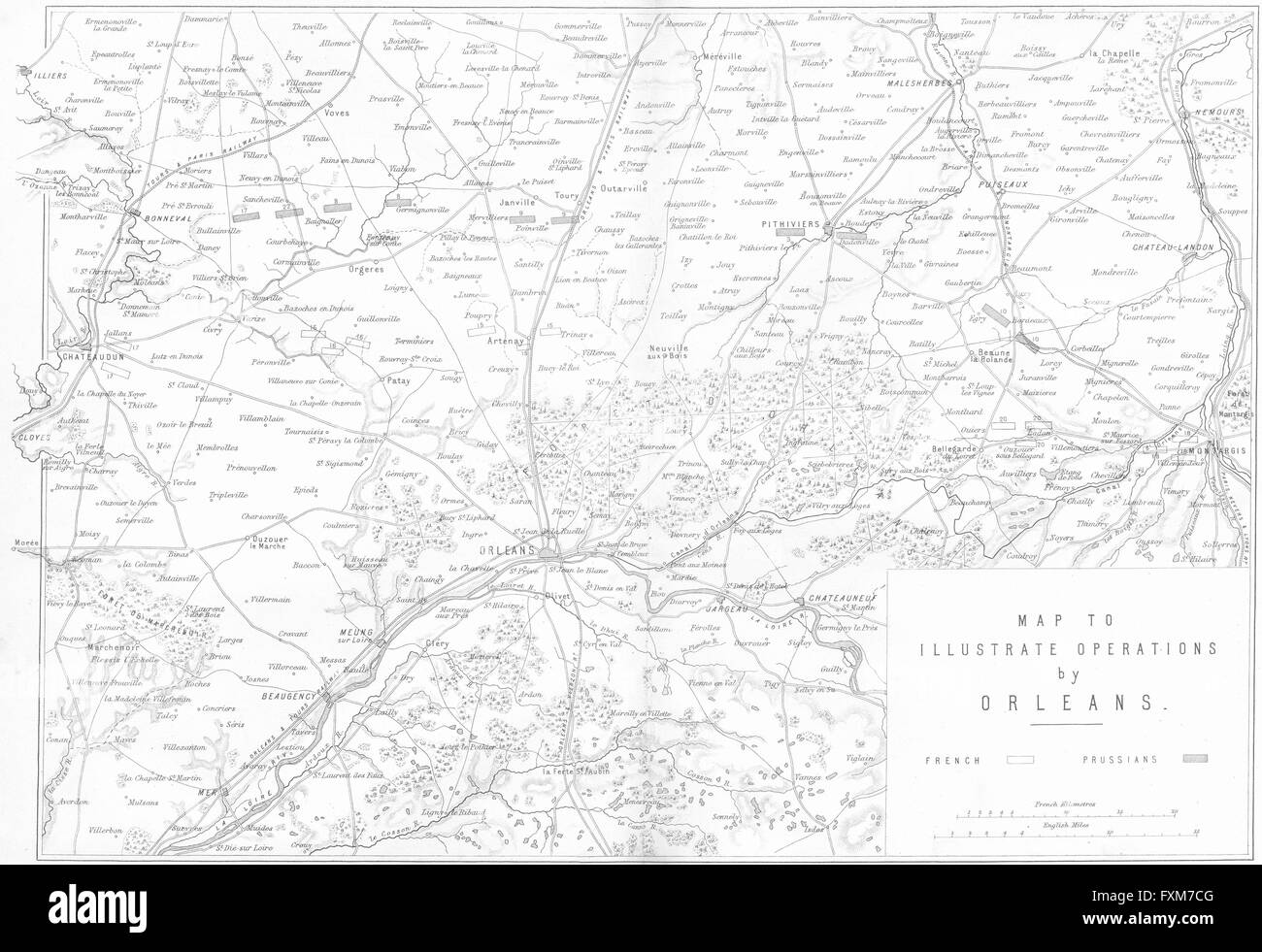 ORLEANS: operations map: Franco-Prussian war, 1875 Stock Photohttps://www.alamy.com/image-license-details/?v=1https://www.alamy.com/stock-photo-orleans-operations-map-franco-prussian-war-1875-102477776.html
RFFXM7CG–ORLEANS: operations map: Franco-Prussian war, 1875
 Franco-Prussian War (1870-1871). Armistice ceremony and capitulation of Paris, held on 28 January 1871 at the Palace of Versailles, between Jules Favre (1809-1880) and Otto von Bismarck (1815-1898). Favre undertook, on behalf of the French government, to hand over Alsace and Lorraine to Germany and to pay war reparations. Drawing by Miranda. Engraving by Capuz. 'Historia de la Guerra de Francia y Prusia' (History of the War between France and Prussia). Volume II. Published in Barcelona, 1871. Stock Photohttps://www.alamy.com/image-license-details/?v=1https://www.alamy.com/franco-prussian-war-1870-1871-armistice-ceremony-and-capitulation-of-paris-held-on-28-january-1871-at-the-palace-of-versailles-between-jules-favre-1809-1880-and-otto-von-bismarck-1815-1898-favre-undertook-on-behalf-of-the-french-government-to-hand-over-alsace-and-lorraine-to-germany-and-to-pay-war-reparations-drawing-by-miranda-engraving-by-capuz-historia-de-la-guerra-de-francia-y-prusia-history-of-the-war-between-france-and-prussia-volume-ii-published-in-barcelona-1871-image608950265.html
RM2XAM27N–Franco-Prussian War (1870-1871). Armistice ceremony and capitulation of Paris, held on 28 January 1871 at the Palace of Versailles, between Jules Favre (1809-1880) and Otto von Bismarck (1815-1898). Favre undertook, on behalf of the French government, to hand over Alsace and Lorraine to Germany and to pay war reparations. Drawing by Miranda. Engraving by Capuz. 'Historia de la Guerra de Francia y Prusia' (History of the War between France and Prussia). Volume II. Published in Barcelona, 1871.
![Map of South Germany and Bavaria, c1872. 'The territories colored green form part of the North German Confederation'. Also showing Luxembourg, part of Prussia, the Palatinate of Bavaria, Hesse, Baden, Hohenzollern and Wurtemberg. From "The Franco-Prussian War: its causes, incidents and consequences", Volume I, by Captain H M Hozier. [William Mackenzie, London, 1872] Stock Photo Map of South Germany and Bavaria, c1872. 'The territories colored green form part of the North German Confederation'. Also showing Luxembourg, part of Prussia, the Palatinate of Bavaria, Hesse, Baden, Hohenzollern and Wurtemberg. From "The Franco-Prussian War: its causes, incidents and consequences", Volume I, by Captain H M Hozier. [William Mackenzie, London, 1872] Stock Photo](https://c8.alamy.com/comp/2AG0G0N/map-of-south-germany-and-bavaria-c1872-the-territories-colored-green-form-part-of-the-north-german-confederation-also-showing-luxembourg-part-of-prussia-the-palatinate-of-bavaria-hesse-baden-hohenzollern-and-wurtemberg-from-quotthe-franco-prussian-war-its-causes-incidents-and-consequencesquot-volume-i-by-captain-h-m-hozier-william-mackenzie-london-1872-2AG0G0N.jpg) Map of South Germany and Bavaria, c1872. 'The territories colored green form part of the North German Confederation'. Also showing Luxembourg, part of Prussia, the Palatinate of Bavaria, Hesse, Baden, Hohenzollern and Wurtemberg. From "The Franco-Prussian War: its causes, incidents and consequences", Volume I, by Captain H M Hozier. [William Mackenzie, London, 1872] Stock Photohttps://www.alamy.com/image-license-details/?v=1https://www.alamy.com/map-of-south-germany-and-bavaria-c1872-the-territories-colored-green-form-part-of-the-north-german-confederation-also-showing-luxembourg-part-of-prussia-the-palatinate-of-bavaria-hesse-baden-hohenzollern-and-wurtemberg-from-quotthe-franco-prussian-war-its-causes-incidents-and-consequencesquot-volume-i-by-captain-h-m-hozier-william-mackenzie-london-1872-image336844053.html
Map of South Germany and Bavaria, c1872. 'The territories colored green form part of the North German Confederation'. Also showing Luxembourg, part of Prussia, the Palatinate of Bavaria, Hesse, Baden, Hohenzollern and Wurtemberg. From "The Franco-Prussian War: its causes, incidents and consequences", Volume I, by Captain H M Hozier. [William Mackenzie, London, 1872] Stock Photohttps://www.alamy.com/image-license-details/?v=1https://www.alamy.com/map-of-south-germany-and-bavaria-c1872-the-territories-colored-green-form-part-of-the-north-german-confederation-also-showing-luxembourg-part-of-prussia-the-palatinate-of-bavaria-hesse-baden-hohenzollern-and-wurtemberg-from-quotthe-franco-prussian-war-its-causes-incidents-and-consequencesquot-volume-i-by-captain-h-m-hozier-william-mackenzie-london-1872-image336844053.htmlRM2AG0G0N–Map of South Germany and Bavaria, c1872. 'The territories colored green form part of the North German Confederation'. Also showing Luxembourg, part of Prussia, the Palatinate of Bavaria, Hesse, Baden, Hohenzollern and Wurtemberg. From "The Franco-Prussian War: its causes, incidents and consequences", Volume I, by Captain H M Hozier. [William Mackenzie, London, 1872]
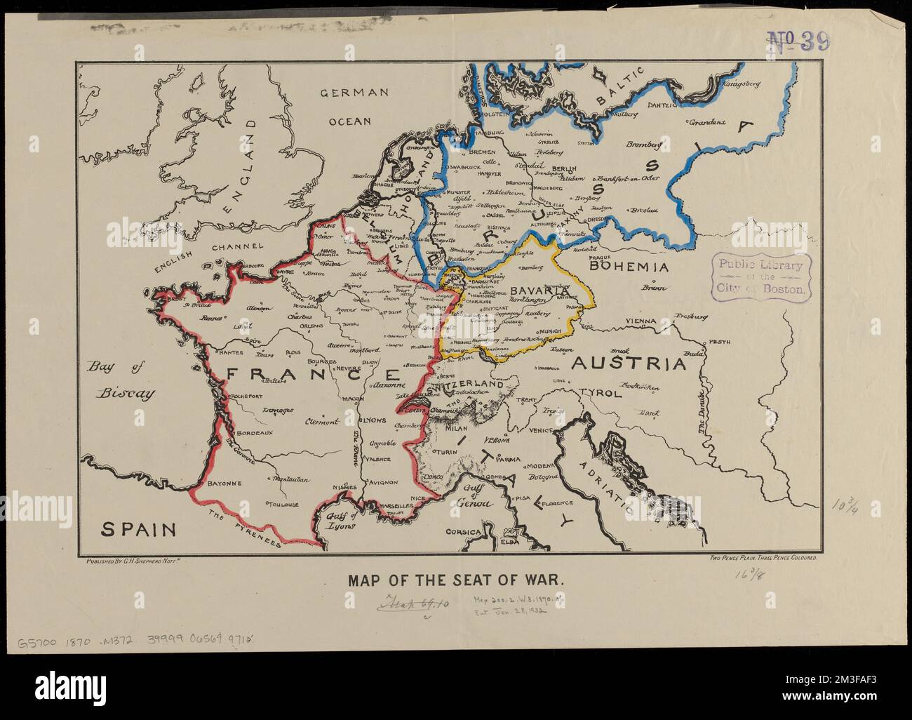 Map of the seat of war , Franco-Prussian War, 1870-1871, Maps, Europe, Maps Norman B. Leventhal Map Center Collection Stock Photohttps://www.alamy.com/image-license-details/?v=1https://www.alamy.com/map-of-the-seat-of-war-franco-prussian-war-1870-1871-maps-europe-maps-norman-b-leventhal-map-center-collection-image501282183.html
RM2M3FAF3–Map of the seat of war , Franco-Prussian War, 1870-1871, Maps, Europe, Maps Norman B. Leventhal Map Center Collection
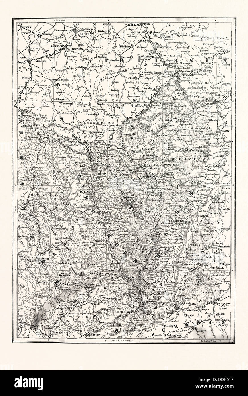 FRANCO-PRUSSIAN WAR: MAP OF ALSACE AND LORRAINE, COUNTIES GIVEN TO THE GERMAN EMPIRE 1870 Stock Photohttps://www.alamy.com/image-license-details/?v=1https://www.alamy.com/stock-photo-franco-prussian-war-map-of-alsace-and-lorraine-counties-given-to-the-59998787.html
RMDDH51R–FRANCO-PRUSSIAN WAR: MAP OF ALSACE AND LORRAINE, COUNTIES GIVEN TO THE GERMAN EMPIRE 1870
 . Deutsch: Karte Schlacht von Weißenburg im Deutsch-Französischen Krieg am 4. August 1870. English: German map of the Battle of Wissembourg in the Franco-Prussian War on August 4th, 1870. 1892. J. Scheibert 76 Battle of wissembourg Stock Photohttps://www.alamy.com/image-license-details/?v=1https://www.alamy.com/deutsch-karte-schlacht-von-weienburg-im-deutsch-franzsischen-krieg-am-4-august-1870-english-german-map-of-the-battle-of-wissembourg-in-the-franco-prussian-war-on-august-4th-1870-1892-j-scheibert-76-battle-of-wissembourg-image188239968.html
RMMX7200–. Deutsch: Karte Schlacht von Weißenburg im Deutsch-Französischen Krieg am 4. August 1870. English: German map of the Battle of Wissembourg in the Franco-Prussian War on August 4th, 1870. 1892. J. Scheibert 76 Battle of wissembourg
 Franco-Prussian War: Schiltigheim, France, Old Map Stock Photohttps://www.alamy.com/image-license-details/?v=1https://www.alamy.com/franco-prussian-war-schiltigheim-france-old-map-image240631467.html
RMRYDKTY–Franco-Prussian War: Schiltigheim, France, Old Map
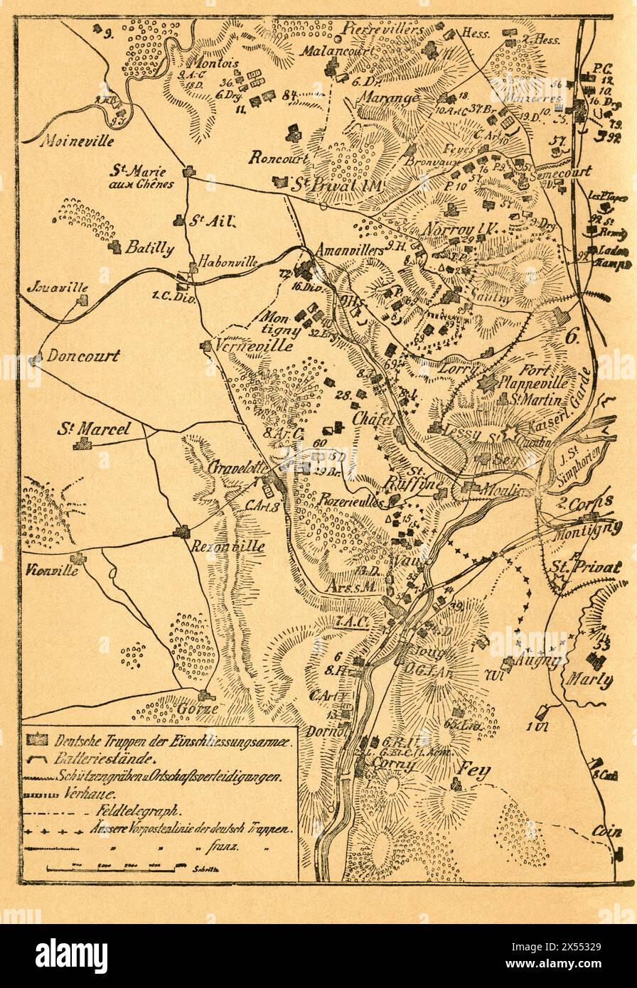 geography / travel, Germany, France, Metz, Franco-Prussian War, the closure on Metz, second part of the map, ARTIST'S COPYRIGHT HAS NOT TO BE CLEARED Stock Photohttps://www.alamy.com/image-license-details/?v=1https://www.alamy.com/geography-travel-germany-france-metz-franco-prussian-war-the-closure-on-metz-second-part-of-the-map-artists-copyright-has-not-to-be-cleared-image605548337.html
RM2X55329–geography / travel, Germany, France, Metz, Franco-Prussian War, the closure on Metz, second part of the map, ARTIST'S COPYRIGHT HAS NOT TO BE CLEARED
 Franco-Prussian War: Schiltigheim, France, Old map Stock Photohttps://www.alamy.com/image-license-details/?v=1https://www.alamy.com/stock-photo-franco-prussian-war-schiltigheim-france-old-map-59995799.html
RMDDH173–Franco-Prussian War: Schiltigheim, France, Old map
 Vintage map of Alsace-Lorraine - the two countries which were taken by Germany from France as a result of the war of 1870-71, and restored back 1918. Stock Photohttps://www.alamy.com/image-license-details/?v=1https://www.alamy.com/vintage-map-of-alsace-lorraine-the-two-countries-which-were-taken-by-germany-from-france-as-a-result-of-the-war-of-1870-71-and-restored-back-1918-image539097169.html
RF2P91YX9–Vintage map of Alsace-Lorraine - the two countries which were taken by Germany from France as a result of the war of 1870-71, and restored back 1918.
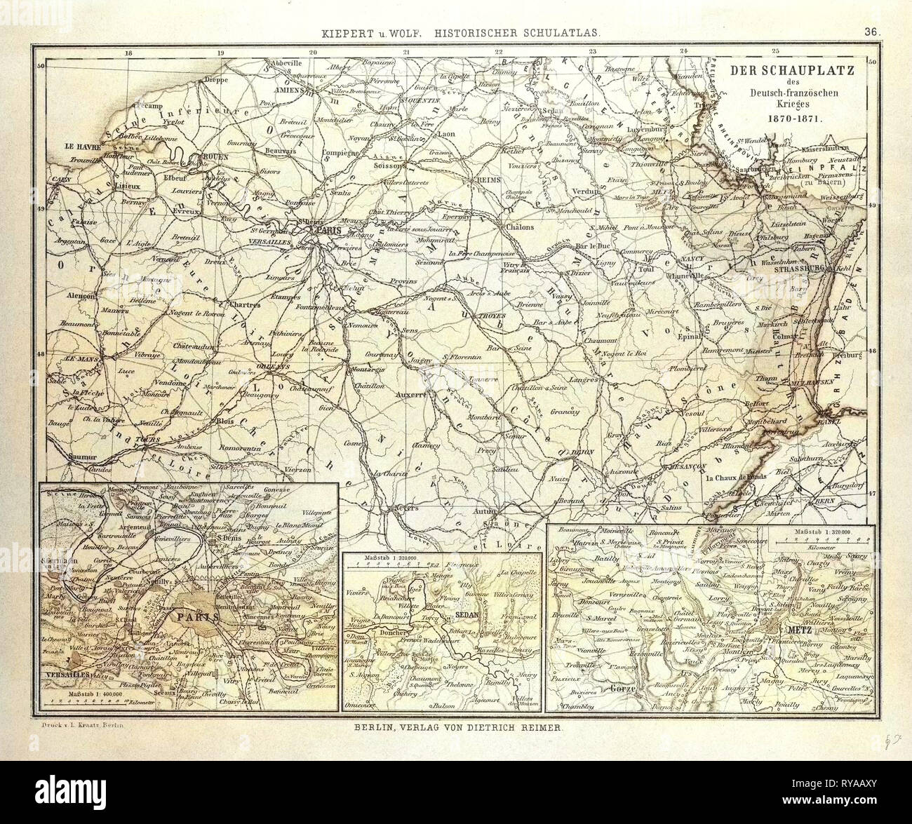 Map of Where the Franco-Prussian War Took Place in France 1870-1871 Stock Photohttps://www.alamy.com/image-license-details/?v=1https://www.alamy.com/map-of-where-the-franco-prussian-war-took-place-in-france-1870-1871-image240558611.html
RMRYAAXY–Map of Where the Franco-Prussian War Took Place in France 1870-1871
 Hindenburg Stock Photohttps://www.alamy.com/image-license-details/?v=1https://www.alamy.com/hindenburg-image501357631.html
RM2M3JPNK–Hindenburg
 FRANCO-PRUSSIAN WAR: RELIEF MAP OF THE THEATRE OF WAR, THE RHINE MOSELLE, 1870 Stock Photohttps://www.alamy.com/image-license-details/?v=1https://www.alamy.com/stock-photo-franco-prussian-war-relief-map-of-the-theatre-of-war-the-rhine-moselle-59998940.html
RMDDH578–FRANCO-PRUSSIAN WAR: RELIEF MAP OF THE THEATRE OF WAR, THE RHINE MOSELLE, 1870
![Image taken from page 80 of '[Cassell's Illustrated History of the War between France and Germany, 1870-1871.]' Image taken from page 80 of '[Cassell's Illustrated History of Stock Photo Image taken from page 80 of '[Cassell's Illustrated History of the War between France and Germany, 1870-1871.]' Image taken from page 80 of '[Cassell's Illustrated History of Stock Photo](https://c8.alamy.com/comp/HBT924/image-taken-from-page-80-of-cassells-illustrated-history-of-the-war-HBT924.jpg) Image taken from page 80 of '[Cassell's Illustrated History of the War between France and Germany, 1870-1871.]' Image taken from page 80 of '[Cassell's Illustrated History of Stock Photohttps://www.alamy.com/image-license-details/?v=1https://www.alamy.com/stock-photo-image-taken-from-page-80-of-cassells-illustrated-history-of-the-war-127767756.html
Image taken from page 80 of '[Cassell's Illustrated History of the War between France and Germany, 1870-1871.]' Image taken from page 80 of '[Cassell's Illustrated History of Stock Photohttps://www.alamy.com/image-license-details/?v=1https://www.alamy.com/stock-photo-image-taken-from-page-80-of-cassells-illustrated-history-of-the-war-127767756.htmlRMHBT924–Image taken from page 80 of '[Cassell's Illustrated History of the War between France and Germany, 1870-1871.]' Image taken from page 80 of '[Cassell's Illustrated History of
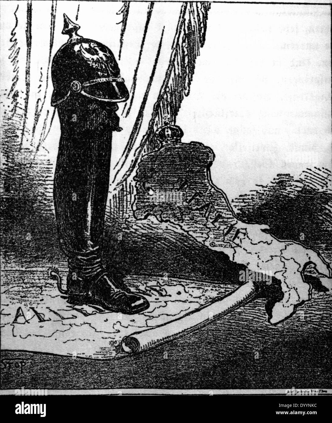 French caricature of the German-Italian relations, 1871/72 Stock Photohttps://www.alamy.com/image-license-details/?v=1https://www.alamy.com/french-caricature-of-the-german-italian-relations-187172-image68836528.html
RMDYYNKC–French caricature of the German-Italian relations, 1871/72
 Basel, Switzerland - November 17, 2020: Strassburger memorial in Basel, Switzerland. (1895), it is in memory of the help that Strassburg received from Stock Photohttps://www.alamy.com/image-license-details/?v=1https://www.alamy.com/basel-switzerland-november-17-2020-strassburger-memorial-in-basel-switzerland-1895-it-is-in-memory-of-the-help-that-strassburg-received-from-image551273250.html
RF2R0TJJA–Basel, Switzerland - November 17, 2020: Strassburger memorial in Basel, Switzerland. (1895), it is in memory of the help that Strassburg received from
 France during Franco Prussian War December1870 Stock Photohttps://www.alamy.com/image-license-details/?v=1https://www.alamy.com/stock-photo-france-during-franco-prussian-war-december1870-139863426.html
RMJ3F96A–France during Franco Prussian War December1870
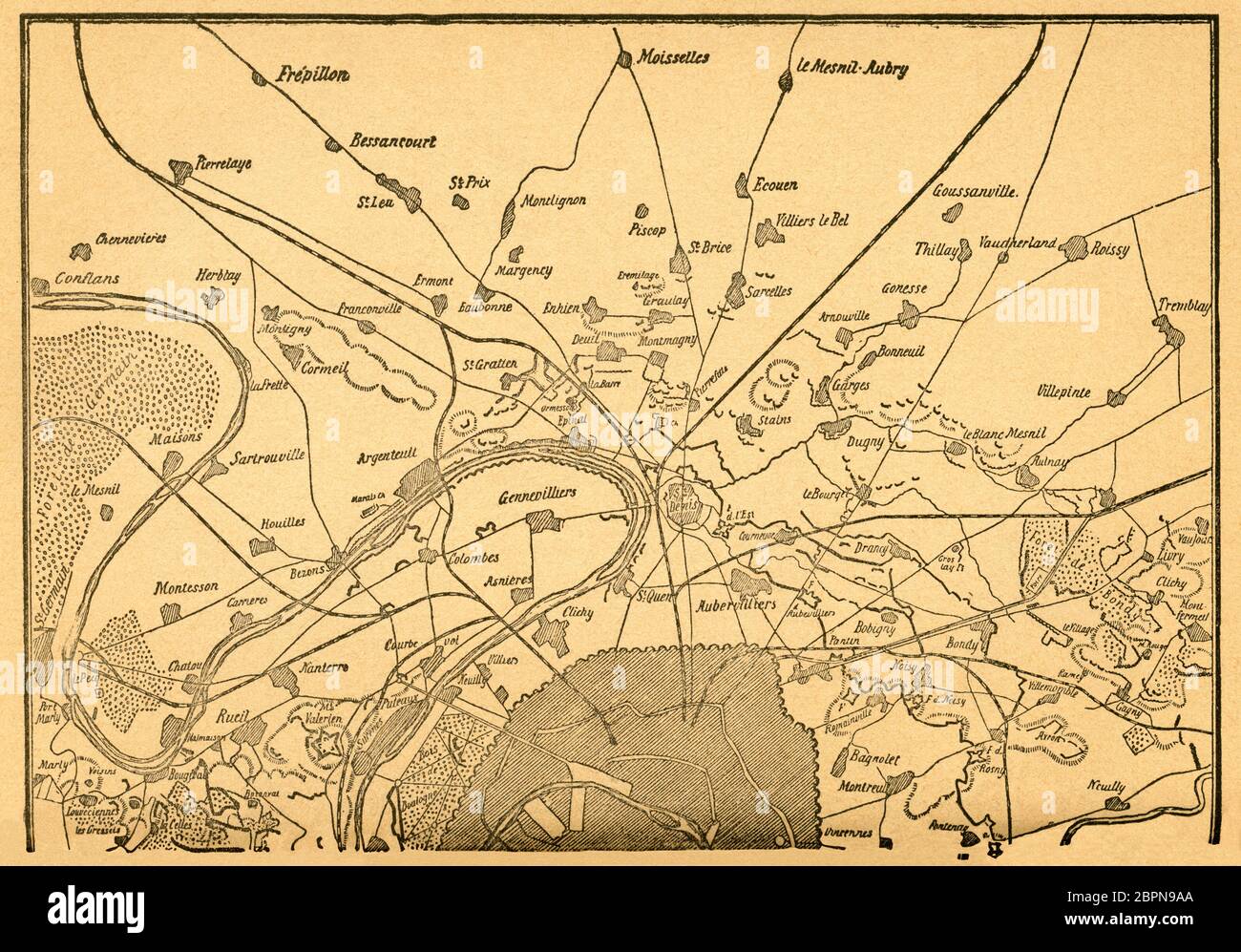 Europa, Deutschland, Frankreich, Deutsch-Französischer Krieg, Einschließung von Paris, zweiter Teil der Karte, Motiv aus : Der Krieg zwischen Frankreich und Deutschland in den Jahren 1870-1871 ' , von J. Scheibert, Verlag von W. Pauli´s Nachfolger ( H. Jerosch ) , Berlin , 1895 . / Europe, Germany, France, Franco-Prussian War, the closure on Paris, second part of the map, image from : ' Der Krieg zwischen Frankreich und Deutschland in den Jahren 1870-1871 ' ( the war between France and Prussian 1870-1871 ) , by J. Scheibert, publishing house W. Pauli´s successsor ( H. Jerosch ) , Berlin, Stock Photohttps://www.alamy.com/image-license-details/?v=1https://www.alamy.com/europa-deutschland-frankreich-deutsch-franzsischer-krieg-einschlieung-von-paris-zweiter-teil-der-karte-motiv-aus-der-krieg-zwischen-frankreich-und-deutschland-in-den-jahren-1870-1871-von-j-scheibert-verlag-von-w-paulis-nachfolger-h-jerosch-berlin-1895-europe-germany-france-franco-prussian-war-the-closure-on-paris-second-part-of-the-map-image-from-der-krieg-zwischen-frankreich-und-deutschland-in-den-jahren-1870-1871-the-war-between-france-and-prussian-1870-1871-by-j-scheibert-publishing-house-w-paulis-successsor-h-jerosch-berlin-image358198130.html
RM2BPN9AA–Europa, Deutschland, Frankreich, Deutsch-Französischer Krieg, Einschließung von Paris, zweiter Teil der Karte, Motiv aus : Der Krieg zwischen Frankreich und Deutschland in den Jahren 1870-1871 ' , von J. Scheibert, Verlag von W. Pauli´s Nachfolger ( H. Jerosch ) , Berlin , 1895 . / Europe, Germany, France, Franco-Prussian War, the closure on Paris, second part of the map, image from : ' Der Krieg zwischen Frankreich und Deutschland in den Jahren 1870-1871 ' ( the war between France and Prussian 1870-1871 ) , by J. Scheibert, publishing house W. Pauli´s successsor ( H. Jerosch ) , Berlin,
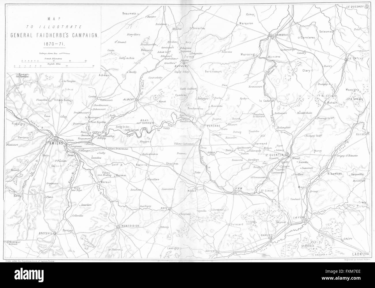 FRANCO-PRUSSIAN WAR: Faidherbe Campaign map Amiens , 1875 Stock Photohttps://www.alamy.com/image-license-details/?v=1https://www.alamy.com/stock-photo-franco-prussian-war-faidherbe-campaign-map-amiens-1875-102477830.html
RFFXM7EE–FRANCO-PRUSSIAN WAR: Faidherbe Campaign map Amiens , 1875
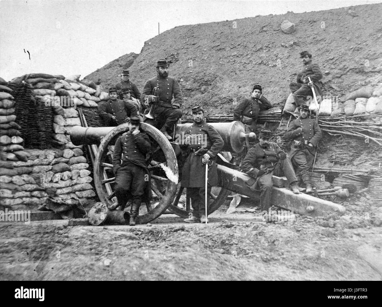 French soldiers in the Franco Prussian War 1870 71 Stock Photohttps://www.alamy.com/image-license-details/?v=1https://www.alamy.com/stock-photo-french-soldiers-in-the-franco-prussian-war-1870-71-139875655.html
RMJ3FTR3–French soldiers in the Franco Prussian War 1870 71
!['Map to Illustrate Operations in the East of France 1870-71', (c1872). Map: 'Drawn under the Superintendence of Captain Hozier', showing the towns of Dijon and Besançon. From "The Franco-Prussian War: its causes, incidents and consequences", Volume II, by Captain H M Hozier. [William Mackenzie, London, 1872] Stock Photo 'Map to Illustrate Operations in the East of France 1870-71', (c1872). Map: 'Drawn under the Superintendence of Captain Hozier', showing the towns of Dijon and Besançon. From "The Franco-Prussian War: its causes, incidents and consequences", Volume II, by Captain H M Hozier. [William Mackenzie, London, 1872] Stock Photo](https://c8.alamy.com/comp/2AG0G3R/map-to-illustrate-operations-in-the-east-of-france-1870-71-c1872-map-drawn-under-the-superintendence-of-captain-hozier-showing-the-towns-of-dijon-and-besanxe7on-from-quotthe-franco-prussian-war-its-causes-incidents-and-consequencesquot-volume-ii-by-captain-h-m-hozier-william-mackenzie-london-1872-2AG0G3R.jpg) 'Map to Illustrate Operations in the East of France 1870-71', (c1872). Map: 'Drawn under the Superintendence of Captain Hozier', showing the towns of Dijon and Besançon. From "The Franco-Prussian War: its causes, incidents and consequences", Volume II, by Captain H M Hozier. [William Mackenzie, London, 1872] Stock Photohttps://www.alamy.com/image-license-details/?v=1https://www.alamy.com/map-to-illustrate-operations-in-the-east-of-france-1870-71-c1872-map-drawn-under-the-superintendence-of-captain-hozier-showing-the-towns-of-dijon-and-besanxe7on-from-quotthe-franco-prussian-war-its-causes-incidents-and-consequencesquot-volume-ii-by-captain-h-m-hozier-william-mackenzie-london-1872-image336844139.html
'Map to Illustrate Operations in the East of France 1870-71', (c1872). Map: 'Drawn under the Superintendence of Captain Hozier', showing the towns of Dijon and Besançon. From "The Franco-Prussian War: its causes, incidents and consequences", Volume II, by Captain H M Hozier. [William Mackenzie, London, 1872] Stock Photohttps://www.alamy.com/image-license-details/?v=1https://www.alamy.com/map-to-illustrate-operations-in-the-east-of-france-1870-71-c1872-map-drawn-under-the-superintendence-of-captain-hozier-showing-the-towns-of-dijon-and-besanxe7on-from-quotthe-franco-prussian-war-its-causes-incidents-and-consequencesquot-volume-ii-by-captain-h-m-hozier-william-mackenzie-london-1872-image336844139.htmlRM2AG0G3R–'Map to Illustrate Operations in the East of France 1870-71', (c1872). Map: 'Drawn under the Superintendence of Captain Hozier', showing the towns of Dijon and Besançon. From "The Franco-Prussian War: its causes, incidents and consequences", Volume II, by Captain H M Hozier. [William Mackenzie, London, 1872]
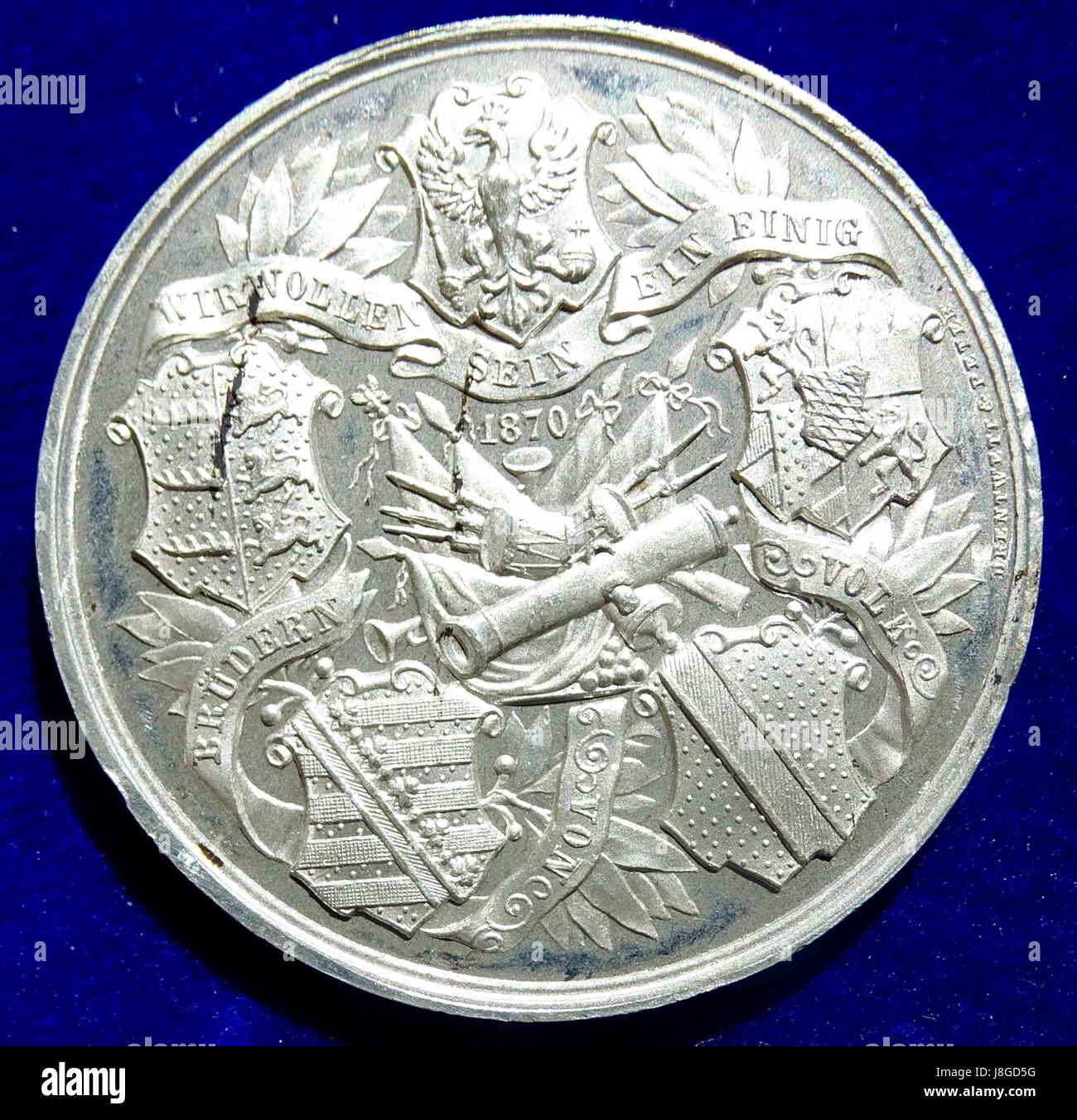 German Medal 1870 Siege of Strasbourg, Alsace, in the Franco Prussian War (reverse) Stock Photohttps://www.alamy.com/image-license-details/?v=1https://www.alamy.com/stock-photo-german-medal-1870-siege-of-strasbourg-alsace-in-the-franco-prussian-142961772.html
RMJ8GD5G–German Medal 1870 Siege of Strasbourg, Alsace, in the Franco Prussian War (reverse)
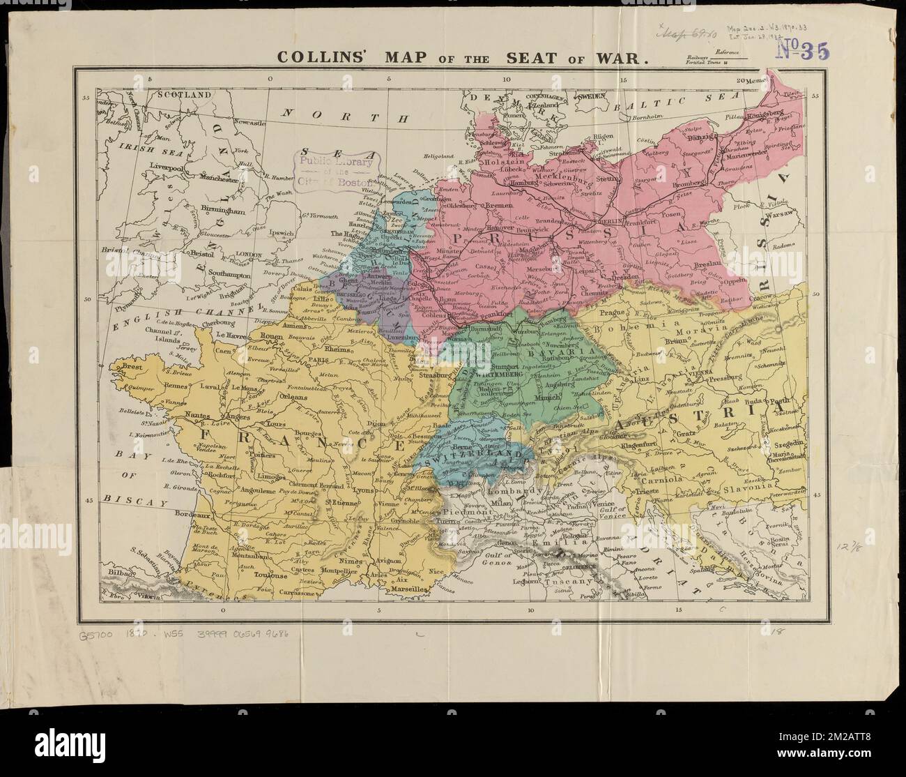 Collins' map of the seat of war , Franco-Prussian War, 1870-1871, Maps, Europe, Maps Norman B. Leventhal Map Center Collection Stock Photohttps://www.alamy.com/image-license-details/?v=1https://www.alamy.com/collins-map-of-the-seat-of-war-franco-prussian-war-1870-1871-maps-europe-maps-norman-b-leventhal-map-center-collection-image500569000.html
RM2M2ATT8–Collins' map of the seat of war , Franco-Prussian War, 1870-1871, Maps, Europe, Maps Norman B. Leventhal Map Center Collection
 . Deutsch: Karte Schlacht von Weißenburg im Deutsch-Französischen Krieg am 4. August 1870. English: German map of the Battle of Wissembourg in the Franco-Prussian War on August 4th, 1870. 1892. J. Scheibert 76 Battle of wissembourg Stock Photohttps://www.alamy.com/image-license-details/?v=1https://www.alamy.com/deutsch-karte-schlacht-von-weienburg-im-deutsch-franzsischen-krieg-am-4-august-1870-english-german-map-of-the-battle-of-wissembourg-in-the-franco-prussian-war-on-august-4th-1870-1892-j-scheibert-76-battle-of-wissembourg-image187673039.html
RMMW96TF–. Deutsch: Karte Schlacht von Weißenburg im Deutsch-Französischen Krieg am 4. August 1870. English: German map of the Battle of Wissembourg in the Franco-Prussian War on August 4th, 1870. 1892. J. Scheibert 76 Battle of wissembourg
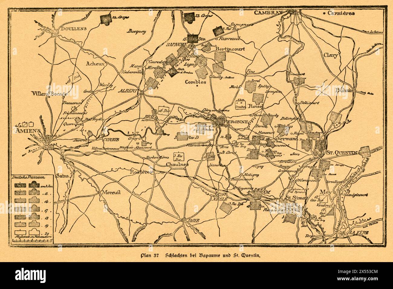 geography / travel, Germany, France, Franco-Prussian War, ARTIST'S COPYRIGHT HAS NOT TO BE CLEARED Stock Photohttps://www.alamy.com/image-license-details/?v=1https://www.alamy.com/geography-travel-germany-france-franco-prussian-war-artists-copyright-has-not-to-be-cleared-image605548628.html
RM2X553CM–geography / travel, Germany, France, Franco-Prussian War, ARTIST'S COPYRIGHT HAS NOT TO BE CLEARED
 Alsace - Scenes in the closing stages of The Great War 1918 Stock Photohttps://www.alamy.com/image-license-details/?v=1https://www.alamy.com/alsace-scenes-in-the-closing-stages-of-the-great-war-1918-image539097166.html
RF2P91YX6–Alsace - Scenes in the closing stages of The Great War 1918
 Franco-Prussian War: Relief Map of the Theatre of War, the Rhine Moselle, 1870 Stock Photohttps://www.alamy.com/image-license-details/?v=1https://www.alamy.com/franco-prussian-war-relief-map-of-the-theatre-of-war-the-rhine-moselle-1870-image240633059.html
RMRYDNWR–Franco-Prussian War: Relief Map of the Theatre of War, the Rhine Moselle, 1870
 Image taken from page 521 of 'Cassell's History of the War between France and Germany. 1870-1871' Image taken from page 521 of 'Cassell's Hi Stock Photohttps://www.alamy.com/image-license-details/?v=1https://www.alamy.com/stock-photo-image-taken-from-page-521-of-cassells-history-of-the-war-between-france-132342778.html
RMHK8MFP–Image taken from page 521 of 'Cassell's History of the War between France and Germany. 1870-1871' Image taken from page 521 of 'Cassell's Hi
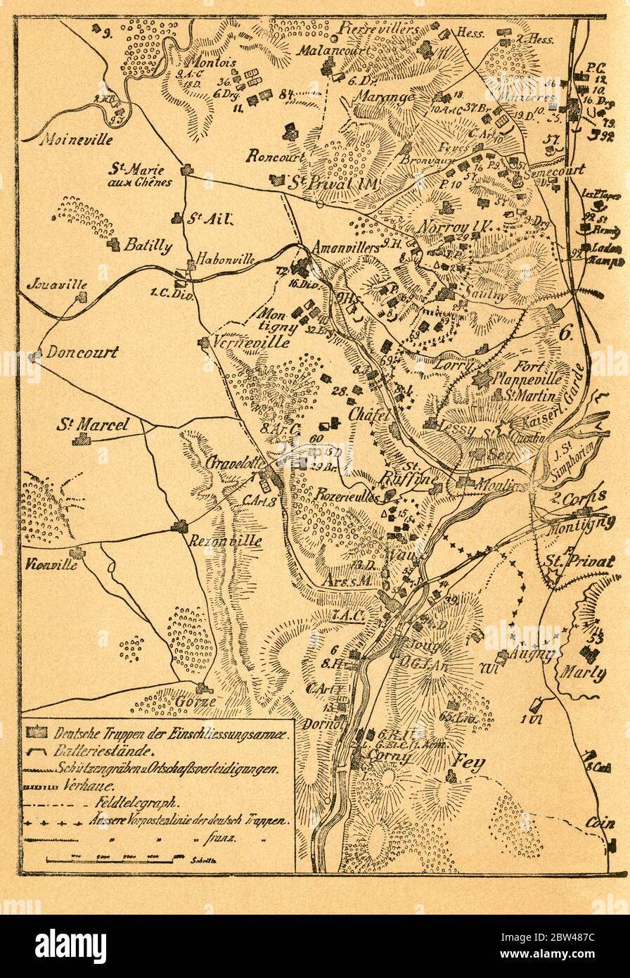 Europa, Deutschland, Frankreich, Deutsch-Französischer Krieg, Metz, Einschließung von Metz , zweiter Teil der Karte, Motiv aus : Der Krieg zwischen Frankreich und Deutschland in den Jahren 1870-1871 ' , von J. Scheibert, Verlag von W. Pauli´s Nachfolger ( H. Jerosch ) , Berlin , 1895 . / Europe, Germany, France, Metz , Franco-Prussian War, the closure on Metz , second part of the map, image from : ' Der Krieg zwischen Frankreich und Deutschland in den Jahren 1870-1871 ' ( the war between France and Prussian 1870-1871 ) , by J. Scheibert, publishing house W. Pauli´s successsor ( H. Jerosch Stock Photohttps://www.alamy.com/image-license-details/?v=1https://www.alamy.com/europa-deutschland-frankreich-deutsch-franzsischer-krieg-metz-einschlieung-von-metz-zweiter-teil-der-karte-motiv-aus-der-krieg-zwischen-frankreich-und-deutschland-in-den-jahren-1870-1871-von-j-scheibert-verlag-von-w-paulis-nachfolger-h-jerosch-berlin-1895-europe-germany-france-metz-franco-prussian-war-the-closure-on-metz-second-part-of-the-map-image-from-der-krieg-zwischen-frankreich-und-deutschland-in-den-jahren-1870-1871-the-war-between-france-and-prussian-1870-1871-by-j-scheibert-publishing-house-w-paulis-successsor-h-jerosch-image359668048.html
RM2BW487C–Europa, Deutschland, Frankreich, Deutsch-Französischer Krieg, Metz, Einschließung von Metz , zweiter Teil der Karte, Motiv aus : Der Krieg zwischen Frankreich und Deutschland in den Jahren 1870-1871 ' , von J. Scheibert, Verlag von W. Pauli´s Nachfolger ( H. Jerosch ) , Berlin , 1895 . / Europe, Germany, France, Metz , Franco-Prussian War, the closure on Metz , second part of the map, image from : ' Der Krieg zwischen Frankreich und Deutschland in den Jahren 1870-1871 ' ( the war between France and Prussian 1870-1871 ) , by J. Scheibert, publishing house W. Pauli´s successsor ( H. Jerosch
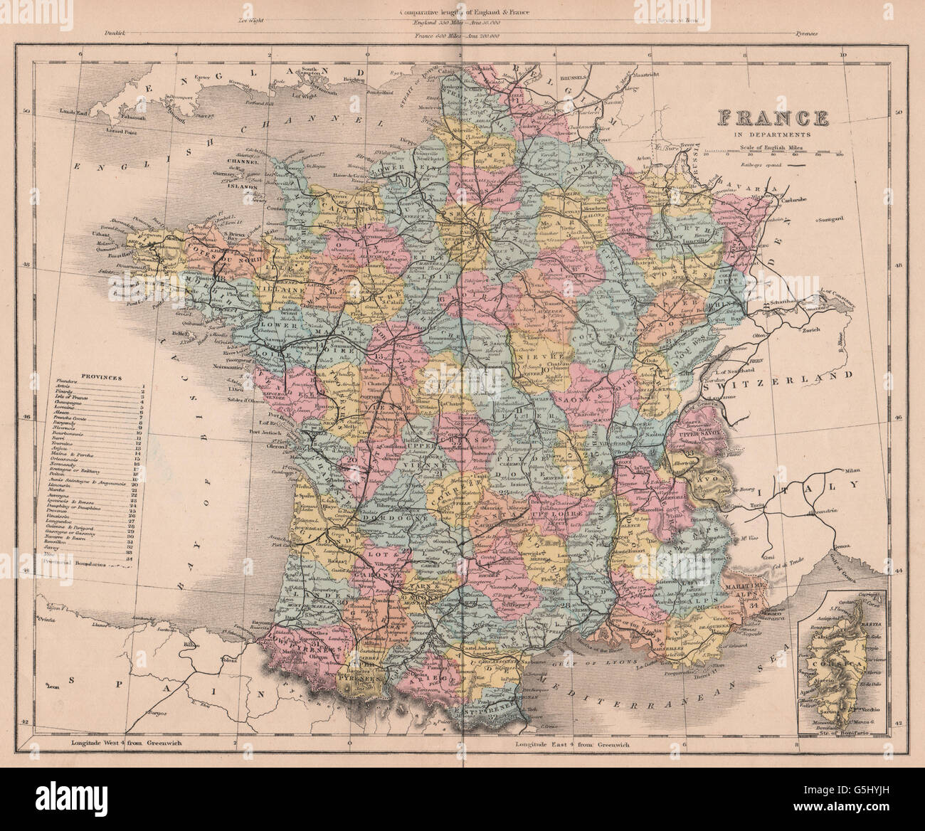 FRANCO-PRUSSIAN WAR: France in Departments, 1875 antique map Stock Photohttps://www.alamy.com/image-license-details/?v=1https://www.alamy.com/stock-photo-franco-prussian-war-france-in-departments-1875-antique-map-106730361.html
RFG5HYJH–FRANCO-PRUSSIAN WAR: France in Departments, 1875 antique map
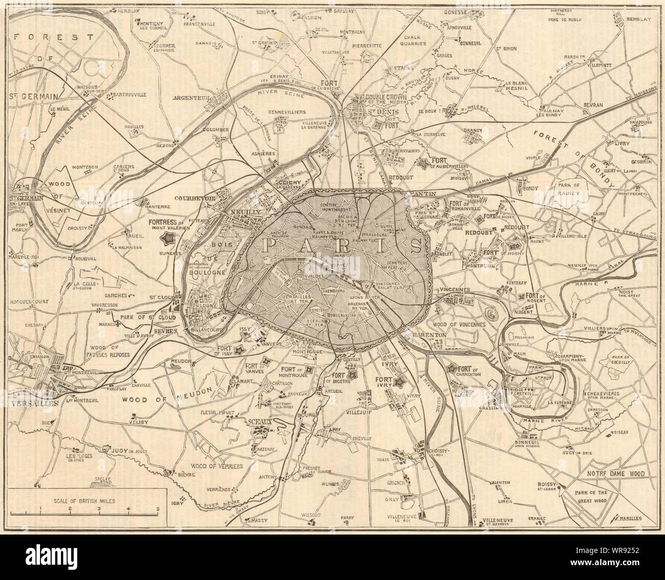 Franco-Prussian War: Fortifications of Paris 1870 map antique ILN full page Stock Photohttps://www.alamy.com/image-license-details/?v=1https://www.alamy.com/franco-prussian-war-fortifications-of-paris-1870-map-antique-iln-full-page-image272491886.html
RFWR9252–Franco-Prussian War: Fortifications of Paris 1870 map antique ILN full page
![Map of Prussia, c1872. Showing the various regions including Holstein, Hanover, Westphalia, Lower Rhine, Lorraine, Nassau, Cassel, Saxony, Brandedburg, Silesia, Pomerania, West Prussia, East Prussia and Posen. From "The Franco-Prussian War: its causes, incidents and consequences", Volume I, by Captain H M Hozier. [William Mackenzie, London, 1872] Stock Photo Map of Prussia, c1872. Showing the various regions including Holstein, Hanover, Westphalia, Lower Rhine, Lorraine, Nassau, Cassel, Saxony, Brandedburg, Silesia, Pomerania, West Prussia, East Prussia and Posen. From "The Franco-Prussian War: its causes, incidents and consequences", Volume I, by Captain H M Hozier. [William Mackenzie, London, 1872] Stock Photo](https://c8.alamy.com/comp/2AG0G08/map-of-prussia-c1872-showing-the-various-regions-including-holstein-hanover-westphalia-lower-rhine-lorraine-nassau-cassel-saxony-brandedburg-silesia-pomerania-west-prussia-east-prussia-and-posen-from-quotthe-franco-prussian-war-its-causes-incidents-and-consequencesquot-volume-i-by-captain-h-m-hozier-william-mackenzie-london-1872-2AG0G08.jpg) Map of Prussia, c1872. Showing the various regions including Holstein, Hanover, Westphalia, Lower Rhine, Lorraine, Nassau, Cassel, Saxony, Brandedburg, Silesia, Pomerania, West Prussia, East Prussia and Posen. From "The Franco-Prussian War: its causes, incidents and consequences", Volume I, by Captain H M Hozier. [William Mackenzie, London, 1872] Stock Photohttps://www.alamy.com/image-license-details/?v=1https://www.alamy.com/map-of-prussia-c1872-showing-the-various-regions-including-holstein-hanover-westphalia-lower-rhine-lorraine-nassau-cassel-saxony-brandedburg-silesia-pomerania-west-prussia-east-prussia-and-posen-from-quotthe-franco-prussian-war-its-causes-incidents-and-consequencesquot-volume-i-by-captain-h-m-hozier-william-mackenzie-london-1872-image336844040.html
Map of Prussia, c1872. Showing the various regions including Holstein, Hanover, Westphalia, Lower Rhine, Lorraine, Nassau, Cassel, Saxony, Brandedburg, Silesia, Pomerania, West Prussia, East Prussia and Posen. From "The Franco-Prussian War: its causes, incidents and consequences", Volume I, by Captain H M Hozier. [William Mackenzie, London, 1872] Stock Photohttps://www.alamy.com/image-license-details/?v=1https://www.alamy.com/map-of-prussia-c1872-showing-the-various-regions-including-holstein-hanover-westphalia-lower-rhine-lorraine-nassau-cassel-saxony-brandedburg-silesia-pomerania-west-prussia-east-prussia-and-posen-from-quotthe-franco-prussian-war-its-causes-incidents-and-consequencesquot-volume-i-by-captain-h-m-hozier-william-mackenzie-london-1872-image336844040.htmlRM2AG0G08–Map of Prussia, c1872. Showing the various regions including Holstein, Hanover, Westphalia, Lower Rhine, Lorraine, Nassau, Cassel, Saxony, Brandedburg, Silesia, Pomerania, West Prussia, East Prussia and Posen. From "The Franco-Prussian War: its causes, incidents and consequences", Volume I, by Captain H M Hozier. [William Mackenzie, London, 1872]
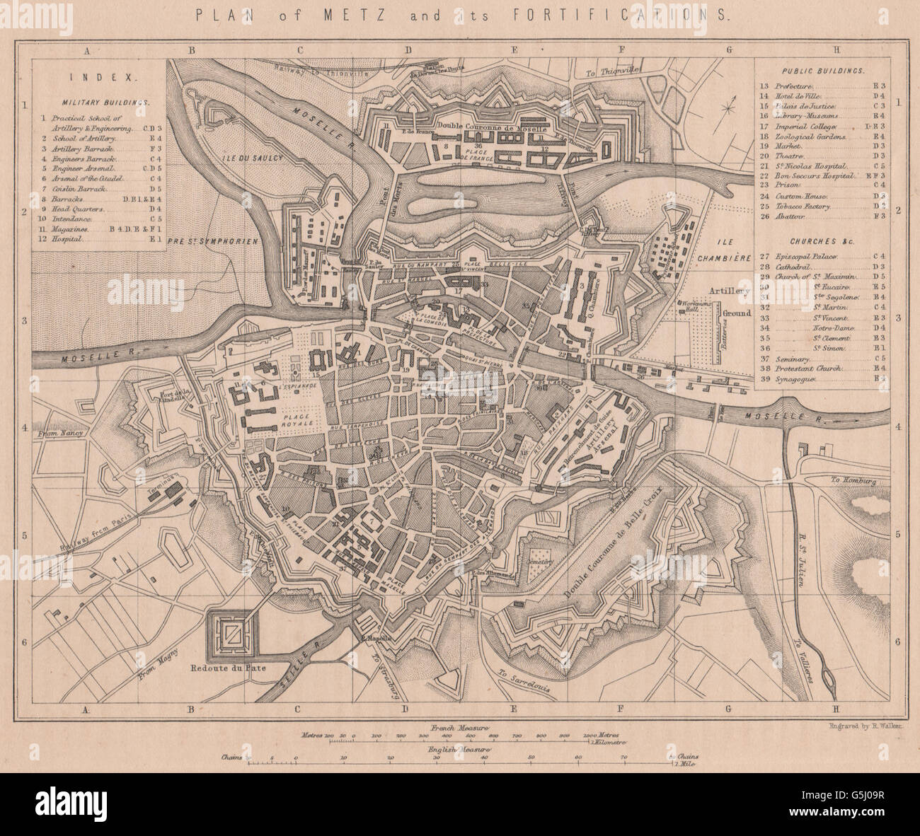 FRANCO-PRUSSIAN WAR: Plan of Metz and its Fortifications. Moselle, 1875 map Stock Photohttps://www.alamy.com/image-license-details/?v=1https://www.alamy.com/stock-photo-franco-prussian-war-plan-of-metz-and-its-fortifications-moselle-1875-106730899.html
RFG5J09R–FRANCO-PRUSSIAN WAR: Plan of Metz and its Fortifications. Moselle, 1875 map
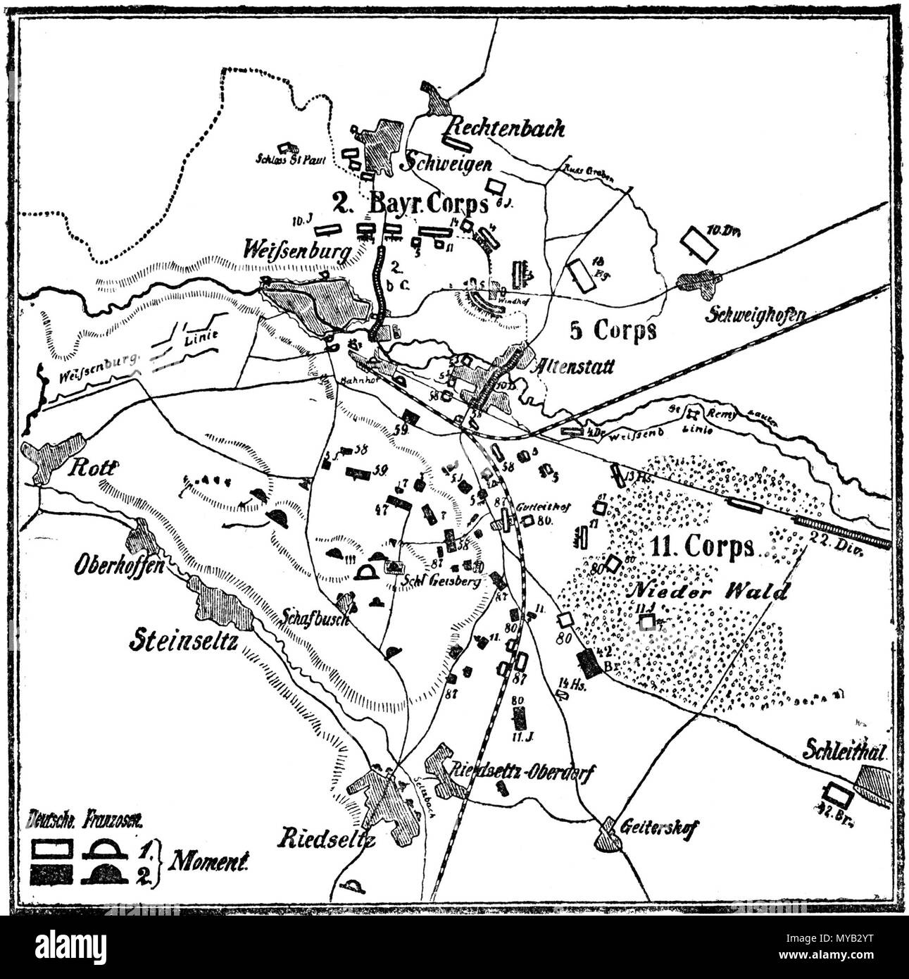 . Deutsch: Karte Schlacht von Weißenburg im Deutsch-Französischen Krieg am 4. August 1870. English: German map of the Battle of Wissembourg in the Franco-Prussian War on August 4th, 1870. 1892. J. Scheibert 67 Battle of wissembourg Stock Photohttps://www.alamy.com/image-license-details/?v=1https://www.alamy.com/deutsch-karte-schlacht-von-weienburg-im-deutsch-franzsischen-krieg-am-4-august-1870-english-german-map-of-the-battle-of-wissembourg-in-the-franco-prussian-war-on-august-4th-1870-1892-j-scheibert-67-battle-of-wissembourg-image188943212.html
RMMYB2YT–. Deutsch: Karte Schlacht von Weißenburg im Deutsch-Französischen Krieg am 4. August 1870. English: German map of the Battle of Wissembourg in the Franco-Prussian War on August 4th, 1870. 1892. J. Scheibert 67 Battle of wissembourg
 German Medal 1870 Siege of Strasbourg, Alsace, in the Franco Prussian War (obverse) Stock Photohttps://www.alamy.com/image-license-details/?v=1https://www.alamy.com/stock-photo-german-medal-1870-siege-of-strasbourg-alsace-in-the-franco-prussian-142961771.html
RMJ8GD5F–German Medal 1870 Siege of Strasbourg, Alsace, in the Franco Prussian War (obverse)
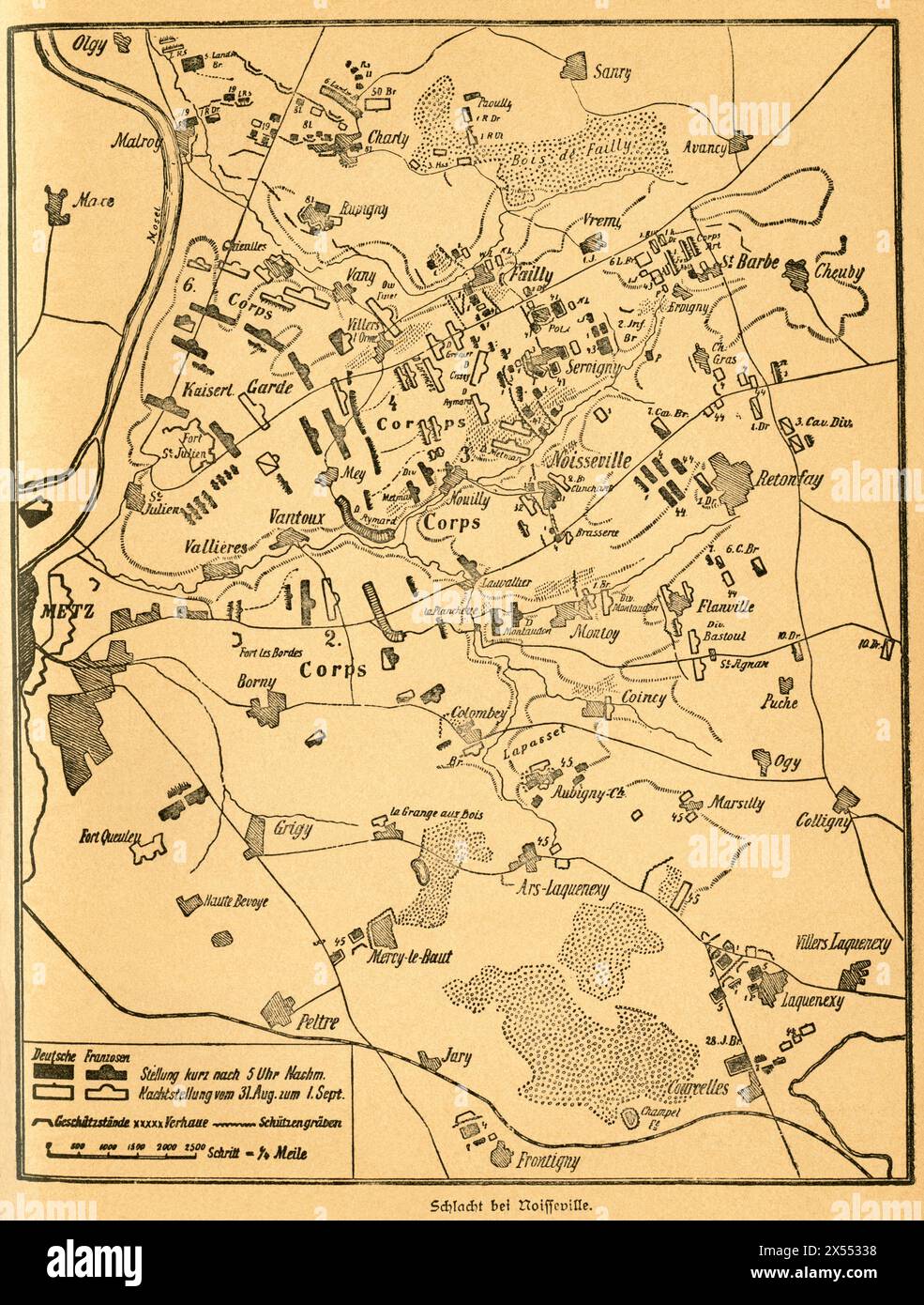 geography / travel, Germany, France, Franco-Prussian War, battle of Noisseville, ARTIST'S COPYRIGHT HAS NOT TO BE CLEARED Stock Photohttps://www.alamy.com/image-license-details/?v=1https://www.alamy.com/geography-travel-germany-france-franco-prussian-war-battle-of-noisseville-artists-copyright-has-not-to-be-cleared-image605548364.html
RM2X55338–geography / travel, Germany, France, Franco-Prussian War, battle of Noisseville, ARTIST'S COPYRIGHT HAS NOT TO BE CLEARED
 German crown Prince Friedrich Wilhelm contemplating the corpse of French general Abel Douay, Franco Prussian War, 1870 Stock Photohttps://www.alamy.com/image-license-details/?v=1https://www.alamy.com/stock-photo-german-crown-prince-friedrich-wilhelm-contemplating-the-corpse-of-139979456.html
RMJ3MH68–German crown Prince Friedrich Wilhelm contemplating the corpse of French general Abel Douay, Franco Prussian War, 1870
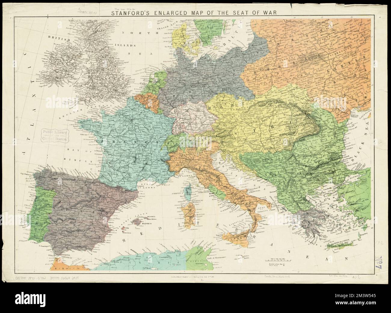 Stanford's enlarged map of the seat of war , Franco-Prussian War, 1870-1871, Europe, Maps Norman B. Leventhal Map Center Collection Stock Photohttps://www.alamy.com/image-license-details/?v=1https://www.alamy.com/stanfords-enlarged-map-of-the-seat-of-war-franco-prussian-war-1870-1871-europe-maps-norman-b-leventhal-map-center-collection-image501497477.html
RM2M3W545–Stanford's enlarged map of the seat of war , Franco-Prussian War, 1870-1871, Europe, Maps Norman B. Leventhal Map Center Collection
![76 of '[The Young Franc-Tireurs, and their Adventures in the Franco-Prussian War ... With illustrations by R. T. Landells.]' Stock Photo 76 of '[The Young Franc-Tireurs, and their Adventures in the Franco-Prussian War ... With illustrations by R. T. Landells.]' Stock Photo](https://c8.alamy.com/comp/FG668D/76-of-the-young-franc-tireurs-and-their-adventures-in-the-franco-prussian-FG668D.jpg) 76 of '[The Young Franc-Tireurs, and their Adventures in the Franco-Prussian War ... With illustrations by R. T. Landells.]' Stock Photohttps://www.alamy.com/image-license-details/?v=1https://www.alamy.com/stock-photo-76-of-the-young-franc-tireurs-and-their-adventures-in-the-franco-prussian-96022989.html
76 of '[The Young Franc-Tireurs, and their Adventures in the Franco-Prussian War ... With illustrations by R. T. Landells.]' Stock Photohttps://www.alamy.com/image-license-details/?v=1https://www.alamy.com/stock-photo-76-of-the-young-franc-tireurs-and-their-adventures-in-the-franco-prussian-96022989.htmlRFFG668D–76 of '[The Young Franc-Tireurs, and their Adventures in the Franco-Prussian War ... With illustrations by R. T. Landells.]'
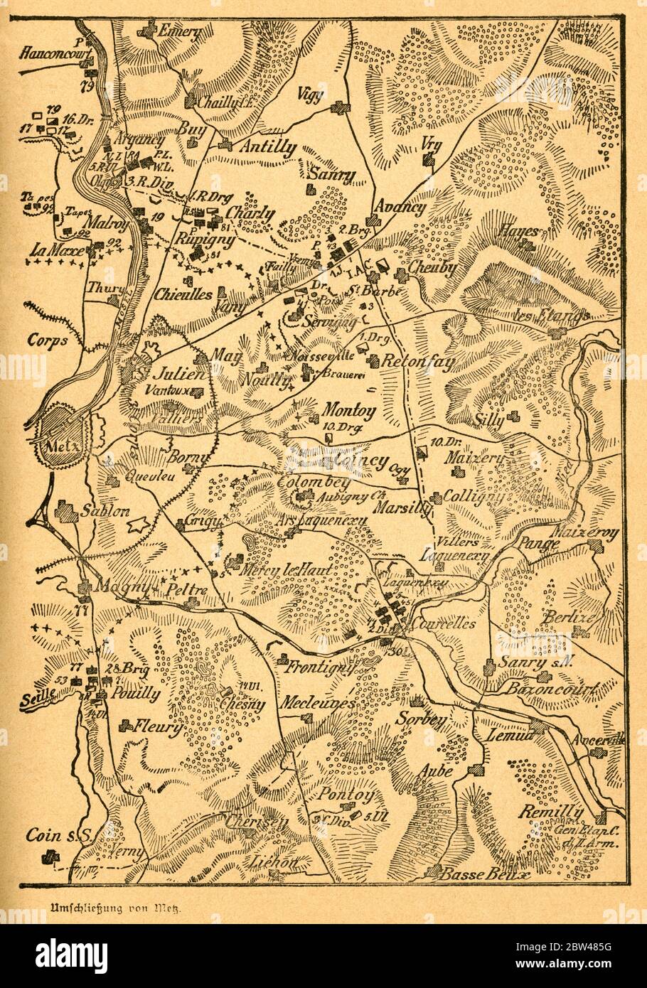 Europa, Deutschland, Frankreich, Deutsch-Französischer Krieg, Metz , Einschließung von Metz , erster Teil der Karte, Motiv aus : Der Krieg zwischen Frankreich und Deutschland in den Jahren 1870-1871 ' , von J. Scheibert, Verlag von W. Pauli´s Nachfolger ( H. Jerosch ) , Berlin , 1895 . / Europe, Germany, France, Metz, Franco-Prussian War, the closure on Metz , first part of the map, image from : ' Der Krieg zwischen Frankreich und Deutschland in den Jahren 1870-1871 ' ( the war between France and Prussian 1870-1871 ) , by J. Scheibert, publishing house W. Pauli´s successsor ( H. Jerosch ) Stock Photohttps://www.alamy.com/image-license-details/?v=1https://www.alamy.com/europa-deutschland-frankreich-deutsch-franzsischer-krieg-metz-einschlieung-von-metz-erster-teil-der-karte-motiv-aus-der-krieg-zwischen-frankreich-und-deutschland-in-den-jahren-1870-1871-von-j-scheibert-verlag-von-w-paulis-nachfolger-h-jerosch-berlin-1895-europe-germany-france-metz-franco-prussian-war-the-closure-on-metz-first-part-of-the-map-image-from-der-krieg-zwischen-frankreich-und-deutschland-in-den-jahren-1870-1871-the-war-between-france-and-prussian-1870-1871-by-j-scheibert-publishing-house-w-paulis-successsor-h-jerosch-image359667996.html
RM2BW485G–Europa, Deutschland, Frankreich, Deutsch-Französischer Krieg, Metz , Einschließung von Metz , erster Teil der Karte, Motiv aus : Der Krieg zwischen Frankreich und Deutschland in den Jahren 1870-1871 ' , von J. Scheibert, Verlag von W. Pauli´s Nachfolger ( H. Jerosch ) , Berlin , 1895 . / Europe, Germany, France, Metz, Franco-Prussian War, the closure on Metz , first part of the map, image from : ' Der Krieg zwischen Frankreich und Deutschland in den Jahren 1870-1871 ' ( the war between France and Prussian 1870-1871 ) , by J. Scheibert, publishing house W. Pauli´s successsor ( H. Jerosch )
![Map of the Battle of Beaumont, 30 August 1870, (c1872). Map: 'Drawn under the Superintendance of Captain Hozier', showing the enemy positions. The Battle of Beaumont was fought near Beaumont-en-Argonne in northern France. From "The Franco-Prussian War: its causes, incidents and consequences", Volume I, by Captain H M Hozier. [William Mackenzie, London, 1872] Stock Photo Map of the Battle of Beaumont, 30 August 1870, (c1872). Map: 'Drawn under the Superintendance of Captain Hozier', showing the enemy positions. The Battle of Beaumont was fought near Beaumont-en-Argonne in northern France. From "The Franco-Prussian War: its causes, incidents and consequences", Volume I, by Captain H M Hozier. [William Mackenzie, London, 1872] Stock Photo](https://c8.alamy.com/comp/2AG0G3T/map-of-the-battle-of-beaumont-30-august-1870-c1872-map-drawn-under-the-superintendance-of-captain-hozier-showing-the-enemy-positions-the-battle-of-beaumont-was-fought-near-beaumont-en-argonne-in-northern-france-from-quotthe-franco-prussian-war-its-causes-incidents-and-consequencesquot-volume-i-by-captain-h-m-hozier-william-mackenzie-london-1872-2AG0G3T.jpg) Map of the Battle of Beaumont, 30 August 1870, (c1872). Map: 'Drawn under the Superintendance of Captain Hozier', showing the enemy positions. The Battle of Beaumont was fought near Beaumont-en-Argonne in northern France. From "The Franco-Prussian War: its causes, incidents and consequences", Volume I, by Captain H M Hozier. [William Mackenzie, London, 1872] Stock Photohttps://www.alamy.com/image-license-details/?v=1https://www.alamy.com/map-of-the-battle-of-beaumont-30-august-1870-c1872-map-drawn-under-the-superintendance-of-captain-hozier-showing-the-enemy-positions-the-battle-of-beaumont-was-fought-near-beaumont-en-argonne-in-northern-france-from-quotthe-franco-prussian-war-its-causes-incidents-and-consequencesquot-volume-i-by-captain-h-m-hozier-william-mackenzie-london-1872-image336844140.html
Map of the Battle of Beaumont, 30 August 1870, (c1872). Map: 'Drawn under the Superintendance of Captain Hozier', showing the enemy positions. The Battle of Beaumont was fought near Beaumont-en-Argonne in northern France. From "The Franco-Prussian War: its causes, incidents and consequences", Volume I, by Captain H M Hozier. [William Mackenzie, London, 1872] Stock Photohttps://www.alamy.com/image-license-details/?v=1https://www.alamy.com/map-of-the-battle-of-beaumont-30-august-1870-c1872-map-drawn-under-the-superintendance-of-captain-hozier-showing-the-enemy-positions-the-battle-of-beaumont-was-fought-near-beaumont-en-argonne-in-northern-france-from-quotthe-franco-prussian-war-its-causes-incidents-and-consequencesquot-volume-i-by-captain-h-m-hozier-william-mackenzie-london-1872-image336844140.htmlRM2AG0G3T–Map of the Battle of Beaumont, 30 August 1870, (c1872). Map: 'Drawn under the Superintendance of Captain Hozier', showing the enemy positions. The Battle of Beaumont was fought near Beaumont-en-Argonne in northern France. From "The Franco-Prussian War: its causes, incidents and consequences", Volume I, by Captain H M Hozier. [William Mackenzie, London, 1872]
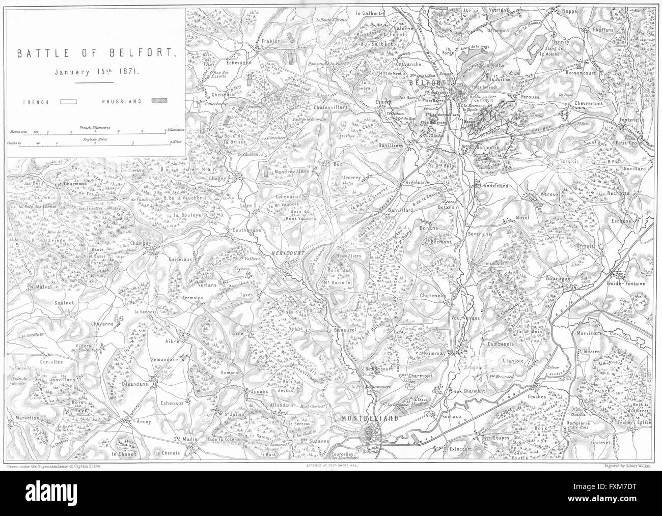 FRANCO-PRUSSIAN WAR: Battle of Belfort, 1871, 1875 antique map Stock Photohttps://www.alamy.com/image-license-details/?v=1https://www.alamy.com/stock-photo-franco-prussian-war-battle-of-belfort-1871-1875-antique-map-102477812.html
RFFXM7DT–FRANCO-PRUSSIAN WAR: Battle of Belfort, 1871, 1875 antique map
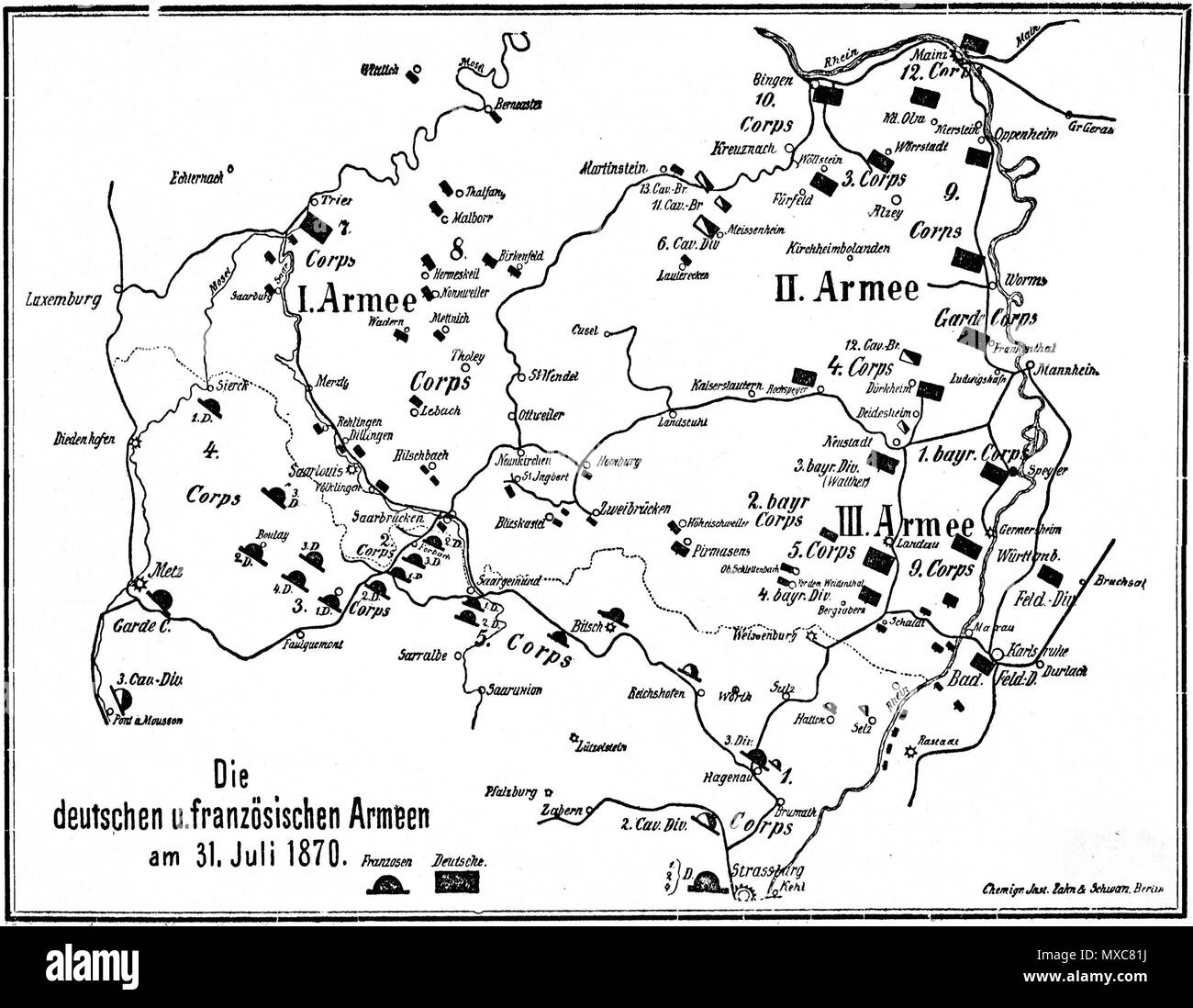 . English: Map of German and French Armies on July, 31st 1870 at the beginning of Franco-Prussian War. Deutsch: Karte der deutschen und französischen Armeen am 31. Juli 1870 zu Beginn des Deutsch-Französischen Krieges. 1892. J. Scheibert 392 Map german and french armys on july 31 1870 Stock Photohttps://www.alamy.com/image-license-details/?v=1https://www.alamy.com/english-map-of-german-and-french-armies-on-july-31st-1870-at-the-beginning-of-franco-prussian-war-deutsch-karte-der-deutschen-und-franzsischen-armeen-am-31-juli-1870-zu-beginn-des-deutsch-franzsischen-krieges-1892-j-scheibert-392-map-german-and-french-armys-on-july-31-1870-image188354478.html
RMMXC81J–. English: Map of German and French Armies on July, 31st 1870 at the beginning of Franco-Prussian War. Deutsch: Karte der deutschen und französischen Armeen am 31. Juli 1870 zu Beginn des Deutsch-Französischen Krieges. 1892. J. Scheibert 392 Map german and french armys on july 31 1870
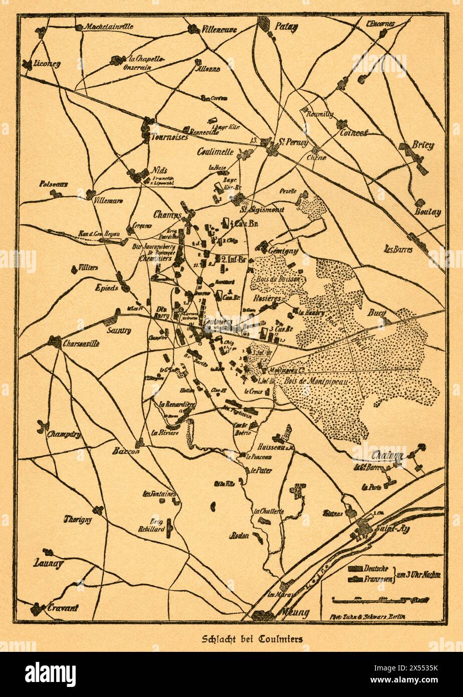 geography / travel, Germany, France, Franco-Prussian War, battle of Coulmiers, ARTIST'S COPYRIGHT HAS NOT TO BE CLEARED Stock Photohttps://www.alamy.com/image-license-details/?v=1https://www.alamy.com/geography-travel-germany-france-franco-prussian-war-battle-of-coulmiers-artists-copyright-has-not-to-be-cleared-image605548431.html
RM2X5535K–geography / travel, Germany, France, Franco-Prussian War, battle of Coulmiers, ARTIST'S COPYRIGHT HAS NOT TO BE CLEARED
 Frederick III Franco Prussian War 1870 Stock Photohttps://www.alamy.com/image-license-details/?v=1https://www.alamy.com/stock-image-frederick-iii-franco-prussian-war-1870-162781604.html
RMKCR9GM–Frederick III Franco Prussian War 1870
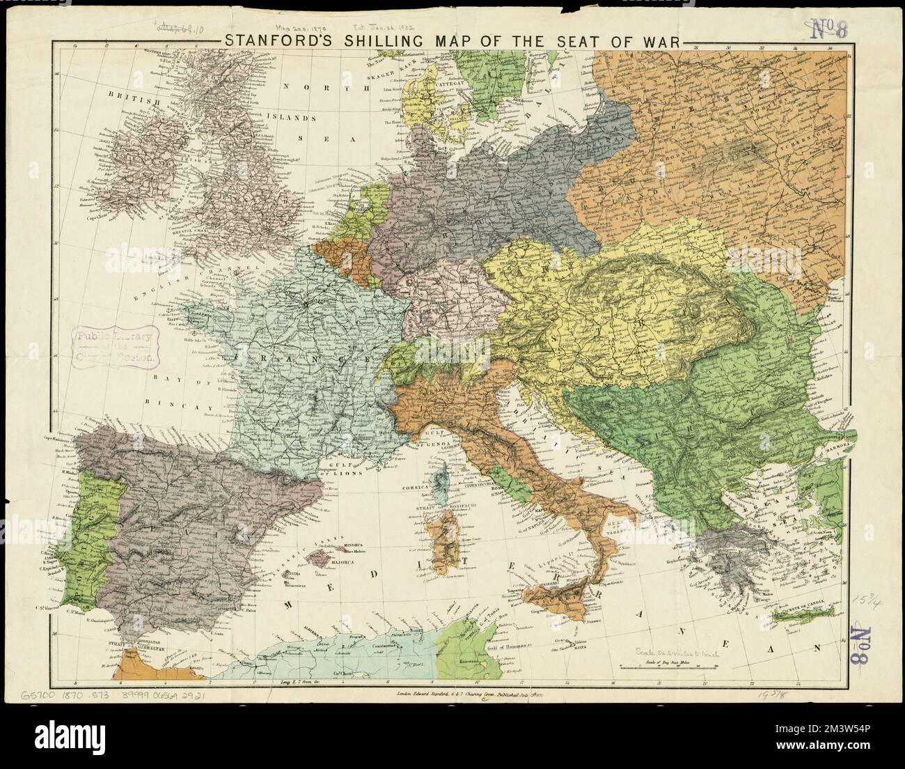 Stanford's shilling map of the seat of war , Franco-Prussian War, 1870-1871, Europe, Maps Norman B. Leventhal Map Center Collection Stock Photohttps://www.alamy.com/image-license-details/?v=1https://www.alamy.com/stanfords-shilling-map-of-the-seat-of-war-franco-prussian-war-1870-1871-europe-maps-norman-b-leventhal-map-center-collection-image501497494.html
RM2M3W54P–Stanford's shilling map of the seat of war , Franco-Prussian War, 1870-1871, Europe, Maps Norman B. Leventhal Map Center Collection
 Franco Prussian War after surrender of Sedan Anton von Werner Stock Photohttps://www.alamy.com/image-license-details/?v=1https://www.alamy.com/stock-image-franco-prussian-war-after-surrender-of-sedan-anton-von-werner-162753624.html
RMKCP1WC–Franco Prussian War after surrender of Sedan Anton von Werner
 German Medal 1870 Siege of Strasbourg, Alsace, in the Franco Prussian War (obverse) Stock Photohttps://www.alamy.com/image-license-details/?v=1https://www.alamy.com/stock-image-german-medal-1870-siege-of-strasbourg-alsace-in-the-franco-prussian-162779084.html
RMKCR6AM–German Medal 1870 Siege of Strasbourg, Alsace, in the Franco Prussian War (obverse)
 2 of 'The Franco-Prussian War in a Nutshell. A daily diary of diplomacy, battles, and war literature. With ... portraits, and Stock Photohttps://www.alamy.com/image-license-details/?v=1https://www.alamy.com/stock-photo-2-of-the-franco-prussian-war-in-a-nutshell-a-daily-diary-of-diplomacy-95772262.html
RFFFPPDX–2 of 'The Franco-Prussian War in a Nutshell. A daily diary of diplomacy, battles, and war literature. With ... portraits, and
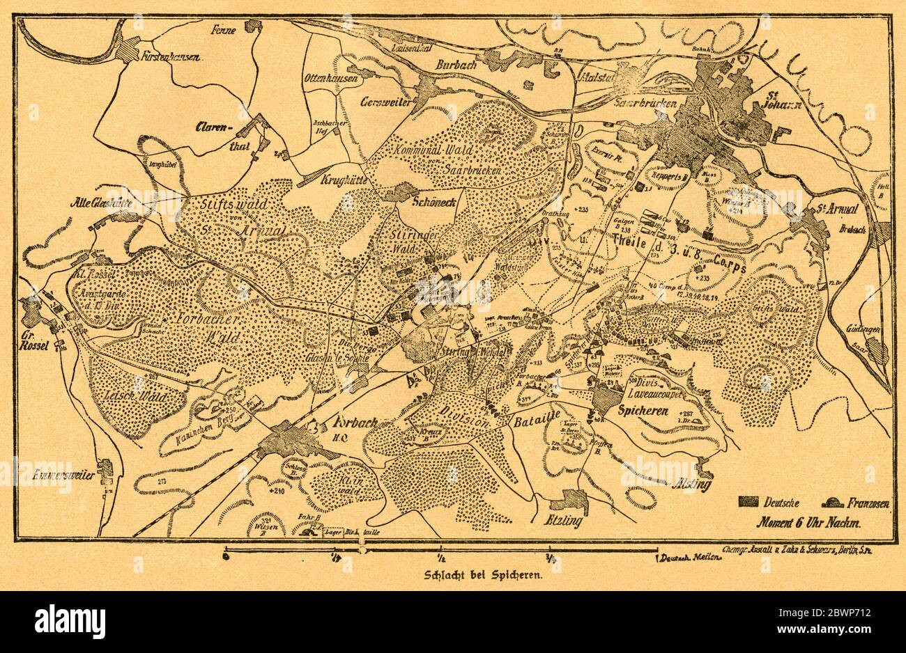 Europa, Deutschland, Frankreich, Deutsch-Französischer Krieg, Schlacht bei Spicheren , Motiv aus : Der Krieg zwischen Frankreich und Deutschland in den Jahren 1870-1871 ' , von J. Scheibert, Verlag von W. Pauli´s Nachfolger ( H. Jerosch ) , Berlin , 1895 . / Europe, Germany, France, Franco-Prussian War, battle of Spicheren , image from : ' Der Krieg zwischen Frankreich und Deutschland in den Jahren 1870-1871 ' ( the war between France and Prussian 1870-1871 ) , by J. Scheibert, publishing house W. Pauli´s successsor ( H. Jerosch ) , Berlin, 1895 . Stock Photohttps://www.alamy.com/image-license-details/?v=1https://www.alamy.com/europa-deutschland-frankreich-deutsch-franzsischer-krieg-schlacht-bei-spicheren-motiv-aus-der-krieg-zwischen-frankreich-und-deutschland-in-den-jahren-1870-1871-von-j-scheibert-verlag-von-w-paulis-nachfolger-h-jerosch-berlin-1895-europe-germany-france-franco-prussian-war-battle-of-spicheren-image-from-der-krieg-zwischen-frankreich-und-deutschland-in-den-jahren-1870-1871-the-war-between-france-and-prussian-1870-1871-by-j-scheibert-publishing-house-w-paulis-successsor-h-jerosch-berlin-1895-image360062222.html
RM2BWP712–Europa, Deutschland, Frankreich, Deutsch-Französischer Krieg, Schlacht bei Spicheren , Motiv aus : Der Krieg zwischen Frankreich und Deutschland in den Jahren 1870-1871 ' , von J. Scheibert, Verlag von W. Pauli´s Nachfolger ( H. Jerosch ) , Berlin , 1895 . / Europe, Germany, France, Franco-Prussian War, battle of Spicheren , image from : ' Der Krieg zwischen Frankreich und Deutschland in den Jahren 1870-1871 ' ( the war between France and Prussian 1870-1871 ) , by J. Scheibert, publishing house W. Pauli´s successsor ( H. Jerosch ) , Berlin, 1895 .
![Map of the Battle of Carignan, 30 August 1870, (c1872). Map: 'Drawn under the Superintendence of Captain Hozier', showing the enemy positions. The Battle of Carignan took place on the same day as the Battle of Beaumont, in northern France. From "The Franco-Prussian War: its causes, incidents and consequences", Volume I, by Captain H M Hozier. [William Mackenzie, London, 1872] Stock Photo Map of the Battle of Carignan, 30 August 1870, (c1872). Map: 'Drawn under the Superintendence of Captain Hozier', showing the enemy positions. The Battle of Carignan took place on the same day as the Battle of Beaumont, in northern France. From "The Franco-Prussian War: its causes, incidents and consequences", Volume I, by Captain H M Hozier. [William Mackenzie, London, 1872] Stock Photo](https://c8.alamy.com/comp/2AG0G33/map-of-the-battle-of-carignan-30-august-1870-c1872-map-drawn-under-the-superintendence-of-captain-hozier-showing-the-enemy-positions-the-battle-of-carignan-took-place-on-the-same-day-as-the-battle-of-beaumont-in-northern-france-from-quotthe-franco-prussian-war-its-causes-incidents-and-consequencesquot-volume-i-by-captain-h-m-hozier-william-mackenzie-london-1872-2AG0G33.jpg) Map of the Battle of Carignan, 30 August 1870, (c1872). Map: 'Drawn under the Superintendence of Captain Hozier', showing the enemy positions. The Battle of Carignan took place on the same day as the Battle of Beaumont, in northern France. From "The Franco-Prussian War: its causes, incidents and consequences", Volume I, by Captain H M Hozier. [William Mackenzie, London, 1872] Stock Photohttps://www.alamy.com/image-license-details/?v=1https://www.alamy.com/map-of-the-battle-of-carignan-30-august-1870-c1872-map-drawn-under-the-superintendence-of-captain-hozier-showing-the-enemy-positions-the-battle-of-carignan-took-place-on-the-same-day-as-the-battle-of-beaumont-in-northern-france-from-quotthe-franco-prussian-war-its-causes-incidents-and-consequencesquot-volume-i-by-captain-h-m-hozier-william-mackenzie-london-1872-image336844119.html
Map of the Battle of Carignan, 30 August 1870, (c1872). Map: 'Drawn under the Superintendence of Captain Hozier', showing the enemy positions. The Battle of Carignan took place on the same day as the Battle of Beaumont, in northern France. From "The Franco-Prussian War: its causes, incidents and consequences", Volume I, by Captain H M Hozier. [William Mackenzie, London, 1872] Stock Photohttps://www.alamy.com/image-license-details/?v=1https://www.alamy.com/map-of-the-battle-of-carignan-30-august-1870-c1872-map-drawn-under-the-superintendence-of-captain-hozier-showing-the-enemy-positions-the-battle-of-carignan-took-place-on-the-same-day-as-the-battle-of-beaumont-in-northern-france-from-quotthe-franco-prussian-war-its-causes-incidents-and-consequencesquot-volume-i-by-captain-h-m-hozier-william-mackenzie-london-1872-image336844119.htmlRM2AG0G33–Map of the Battle of Carignan, 30 August 1870, (c1872). Map: 'Drawn under the Superintendence of Captain Hozier', showing the enemy positions. The Battle of Carignan took place on the same day as the Battle of Beaumont, in northern France. From "The Franco-Prussian War: its causes, incidents and consequences", Volume I, by Captain H M Hozier. [William Mackenzie, London, 1872]
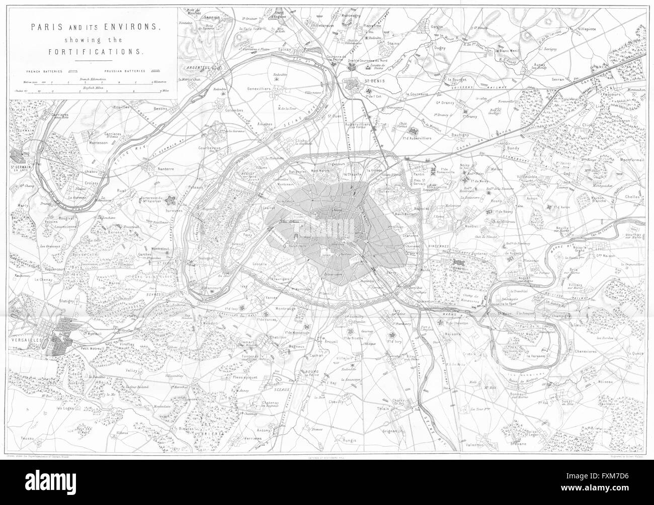 PARIS AREA: Fortifications; Franco-Prussian war, 1875 antique map Stock Photohttps://www.alamy.com/image-license-details/?v=1https://www.alamy.com/stock-photo-paris-area-fortifications-franco-prussian-war-1875-antique-map-102477794.html
RFFXM7D6–PARIS AREA: Fortifications; Franco-Prussian war, 1875 antique map
 . English: Map of German and French Armies on July, 31st 1870 at the beginning of Franco-Prussian War. Deutsch: Karte der deutschen und französischen Armeen am 31. Juli 1870 zu Beginn des Deutsch-Französischen Krieges. 1892. J. Scheibert 342 Map german and french armys on july 31 1870 Stock Photohttps://www.alamy.com/image-license-details/?v=1https://www.alamy.com/english-map-of-german-and-french-armies-on-july-31st-1870-at-the-beginning-of-franco-prussian-war-deutsch-karte-der-deutschen-und-franzsischen-armeen-am-31-juli-1870-zu-beginn-des-deutsch-franzsischen-krieges-1892-j-scheibert-342-map-german-and-french-armys-on-july-31-1870-image189120858.html
RMMYK5GA–. English: Map of German and French Armies on July, 31st 1870 at the beginning of Franco-Prussian War. Deutsch: Karte der deutschen und französischen Armeen am 31. Juli 1870 zu Beginn des Deutsch-Französischen Krieges. 1892. J. Scheibert 342 Map german and french armys on july 31 1870