Maryland avenue Cut Out Stock Images
 NORTHEAST ALONG MARYLAND AVENUE CORRIDOR FROM THIRD STREET, NE.; 3. AERIAL VIEW NORTHEAST ALONG MARYLAND AVENUE CORRIDOR FROM THIRD STREET, NE. - Maryland Avenue, Washington, District of Columbia, DC; Stock Photohttps://www.alamy.com/image-license-details/?v=1https://www.alamy.com/northeast-along-maryland-avenue-corridor-from-third-street-ne-3-aerial-view-northeast-along-maryland-avenue-corridor-from-third-street-ne-maryland-avenue-washington-district-of-columbia-dc-image272348823.html
RMWR2FKK–NORTHEAST ALONG MARYLAND AVENUE CORRIDOR FROM THIRD STREET, NE.; 3. AERIAL VIEW NORTHEAST ALONG MARYLAND AVENUE CORRIDOR FROM THIRD STREET, NE. - Maryland Avenue, Washington, District of Columbia, DC;
 Maryland Avenue, Hillsborough County, US, United States, Florida, N 27 57' 28'', S 82 26' 56'', map, Cartascapes Map published in 2024. Explore Cartascapes, a map revealing Earth's diverse landscapes, cultures, and ecosystems. Journey through time and space, discovering the interconnectedness of our planet's past, present, and future. Stock Photohttps://www.alamy.com/image-license-details/?v=1https://www.alamy.com/maryland-avenue-hillsborough-county-us-united-states-florida-n-27-57-28-s-82-26-56-map-cartascapes-map-published-in-2024-explore-cartascapes-a-map-revealing-earths-diverse-landscapes-cultures-and-ecosystems-journey-through-time-and-space-discovering-the-interconnectedness-of-our-planets-past-present-and-future-image620891816.html
RM2Y241RM–Maryland Avenue, Hillsborough County, US, United States, Florida, N 27 57' 28'', S 82 26' 56'', map, Cartascapes Map published in 2024. Explore Cartascapes, a map revealing Earth's diverse landscapes, cultures, and ecosystems. Journey through time and space, discovering the interconnectedness of our planet's past, present, and future.
 United States National Museum Construction. Also known as 17229Looking northeast.Smithsonian Institution Archives, Record Unit 79, National Museum Building Construction Records, Image No. SIA2009-1959Smithsonian Institution Archives Capital Gallery, Suite 3000, MRC 507; 600 Maryland Avenue, SW; Washington, DC 20024-2520 SIA2009-1959 Stock Photohttps://www.alamy.com/image-license-details/?v=1https://www.alamy.com/united-states-national-museum-construction-also-known-as-17229looking-northeastsmithsonian-institution-archives-record-unit-79-national-museum-building-construction-records-image-no-sia2009-1959smithsonian-institution-archives-capital-gallery-suite-3000-mrc-507-600-maryland-avenue-sw-washington-dc-20024-2520-sia2009-1959-image352205526.html
RM2BD09MP–United States National Museum Construction. Also known as 17229Looking northeast.Smithsonian Institution Archives, Record Unit 79, National Museum Building Construction Records, Image No. SIA2009-1959Smithsonian Institution Archives Capital Gallery, Suite 3000, MRC 507; 600 Maryland Avenue, SW; Washington, DC 20024-2520 SIA2009-1959
 Stratmore Hotel, lower lobby, Maryland Avenue and Boardwalk, Atlantic City, N.J. , Hotels, Tichnor Brothers Collection, postcards of the United States Stock Photohttps://www.alamy.com/image-license-details/?v=1https://www.alamy.com/stratmore-hotel-lower-lobby-maryland-avenue-and-boardwalk-atlantic-city-nj-hotels-tichnor-brothers-collection-postcards-of-the-united-states-image499904209.html
RM2M18GWN–Stratmore Hotel, lower lobby, Maryland Avenue and Boardwalk, Atlantic City, N.J. , Hotels, Tichnor Brothers Collection, postcards of the United States
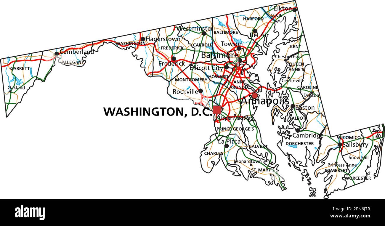
 Maryland road and highway map. Vector illustration. Stock Vectorhttps://www.alamy.com/image-license-details/?v=1https://www.alamy.com/maryland-road-and-highway-map-vector-illustration-image546575227.html
RF2PN6J7R–Maryland road and highway map. Vector illustration.
 Fulton Avenue Bridge-Tunnel. Baltimore, Baltimore City, MD. Sec. 1201, MP 97.56. - Northeast Railroad Corridor, Amtrak route between District of Columbia-Maryland state line and Maryland-Delaware state line, Baltimore, Independent City, MD Stock Photohttps://www.alamy.com/image-license-details/?v=1https://www.alamy.com/fulton-avenue-bridge-tunnel-baltimore-baltimore-city-md-sec-1201-mp-9756-northeast-railroad-corridor-amtrak-route-between-district-of-columbia-maryland-state-line-and-maryland-delaware-state-line-baltimore-independent-city-md-image265237629.html
RMWBEH8D–Fulton Avenue Bridge-Tunnel. Baltimore, Baltimore City, MD. Sec. 1201, MP 97.56. - Northeast Railroad Corridor, Amtrak route between District of Columbia-Maryland state line and Maryland-Delaware state line, Baltimore, Independent City, MD
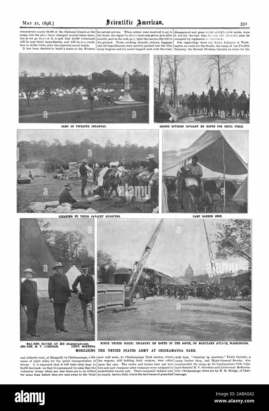
 CAMP OF TWELFTH INFANTRY. SECOND DIVISION CAVALRY EN ROUTE FOR DRILL FIELD. CLEANING UP THIRD CAVALRY QUARTERS. CAMP BARBER SHOP. MAJ.-GEN. BROOKE AT HIS HEADQUARTRRS. NINTH UNITED STATES INFANTRY EN ROUTE TO THE SOUTH ON MARYLAND AVENUE WASHINGTON. ADJ.-GEN. M. V. SHERIDAN. LIEUT. MoKENNA MOBILIZING THE UNITED STATES ARMY AT CHICKAMAUGA PARK. for some time before they are sent away to the front now well worn to Chickamauga Park station where, scientific american, 1898-05-21 Stock Photohttps://www.alamy.com/image-license-details/?v=1https://www.alamy.com/camp-of-twelfth-infantry-second-division-cavalry-en-route-for-drill-field-cleaning-up-third-cavalry-quarters-camp-barber-shop-maj-gen-brooke-at-his-headquartrrs-ninth-united-states-infantry-en-route-to-the-south-on-maryland-avenue-washington-adj-gen-m-v-sheridan-lieut-mokenna-mobilizing-the-united-states-army-at-chickamauga-park-for-some-time-before-they-are-sent-away-to-the-front-now-well-worn-to-chickamauga-park-station-where-scientific-american-1898-05-21-image334342234.html
RM2ABXGX2–CAMP OF TWELFTH INFANTRY. SECOND DIVISION CAVALRY EN ROUTE FOR DRILL FIELD. CLEANING UP THIRD CAVALRY QUARTERS. CAMP BARBER SHOP. MAJ.-GEN. BROOKE AT HIS HEADQUARTRRS. NINTH UNITED STATES INFANTRY EN ROUTE TO THE SOUTH ON MARYLAND AVENUE WASHINGTON. ADJ.-GEN. M. V. SHERIDAN. LIEUT. MoKENNA MOBILIZING THE UNITED STATES ARMY AT CHICKAMAUGA PARK. for some time before they are sent away to the front now well worn to Chickamauga Park station where, scientific american, 1898-05-21
 United States, Baltimore, Maryland, Monument travel landmark vector illustration Stock Vectorhttps://www.alamy.com/image-license-details/?v=1https://www.alamy.com/united-states-baltimore-maryland-monument-travel-landmark-vector-illustration-image544427739.html
RF2PHMR3R–United States, Baltimore, Maryland, Monument travel landmark vector illustration
 Connecticut Avenue Park, Montgomery County, US, United States, Maryland, N 39 3' 45'', S 77 4' 39'', map, Cartascapes Map published in 2024. Explore Cartascapes, a map revealing Earth's diverse landscapes, cultures, and ecosystems. Journey through time and space, discovering the interconnectedness of our planet's past, present, and future. Stock Photohttps://www.alamy.com/image-license-details/?v=1https://www.alamy.com/connecticut-avenue-park-montgomery-county-us-united-states-maryland-n-39-3-45-s-77-4-39-map-cartascapes-map-published-in-2024-explore-cartascapes-a-map-revealing-earths-diverse-landscapes-cultures-and-ecosystems-journey-through-time-and-space-discovering-the-interconnectedness-of-our-planets-past-present-and-future-image621246548.html
RM2Y2M68M–Connecticut Avenue Park, Montgomery County, US, United States, Maryland, N 39 3' 45'', S 77 4' 39'', map, Cartascapes Map published in 2024. Explore Cartascapes, a map revealing Earth's diverse landscapes, cultures, and ecosystems. Journey through time and space, discovering the interconnectedness of our planet's past, present, and future.
 Stratmore Hotel, lower lobby, Maryland Avenue and Boardwalk, Atlantic City, N.J. , Hotels, Tichnor Brothers Collection, postcards of the United States Stock Photohttps://www.alamy.com/image-license-details/?v=1https://www.alamy.com/stratmore-hotel-lower-lobby-maryland-avenue-and-boardwalk-atlantic-city-nj-hotels-tichnor-brothers-collection-postcards-of-the-united-states-image500080000.html
RM2M1GH40–Stratmore Hotel, lower lobby, Maryland Avenue and Boardwalk, Atlantic City, N.J. , Hotels, Tichnor Brothers Collection, postcards of the United States
 CHESTNUT AVENUE BRIDGE. BOWIE, PRINCE GEORGES CO., MD. Sec. 1201,, MP 120.48. - Northeast Railroad Corridor, Amtrak route between District of Columbia-Maryland state line and Maryland-Delaware state line, Baltimore, Independent City, MD Stock Photohttps://www.alamy.com/image-license-details/?v=1https://www.alamy.com/chestnut-avenue-bridge-bowie-prince-georges-co-md-sec-1201-mp-12048-northeast-railroad-corridor-amtrak-route-between-district-of-columbia-maryland-state-line-and-maryland-delaware-state-line-baltimore-independent-city-md-image264485649.html
RMWA8A41–CHESTNUT AVENUE BRIDGE. BOWIE, PRINCE GEORGES CO., MD. Sec. 1201,, MP 120.48. - Northeast Railroad Corridor, Amtrak route between District of Columbia-Maryland state line and Maryland-Delaware state line, Baltimore, Independent City, MD
 Connecticut Avenue Hills, Montgomery County, US, United States, Maryland, N 39 2' 48'', S 77 4' 46'', map, Cartascapes Map published in 2024. Explore Cartascapes, a map revealing Earth's diverse landscapes, cultures, and ecosystems. Journey through time and space, discovering the interconnectedness of our planet's past, present, and future. Stock Photohttps://www.alamy.com/image-license-details/?v=1https://www.alamy.com/connecticut-avenue-hills-montgomery-county-us-united-states-maryland-n-39-2-48-s-77-4-46-map-cartascapes-map-published-in-2024-explore-cartascapes-a-map-revealing-earths-diverse-landscapes-cultures-and-ecosystems-journey-through-time-and-space-discovering-the-interconnectedness-of-our-planets-past-present-and-future-image621180630.html
RM2Y2H66E–Connecticut Avenue Hills, Montgomery County, US, United States, Maryland, N 39 2' 48'', S 77 4' 46'', map, Cartascapes Map published in 2024. Explore Cartascapes, a map revealing Earth's diverse landscapes, cultures, and ecosystems. Journey through time and space, discovering the interconnectedness of our planet's past, present, and future.
 Fulton Avenue Bridge-Tunnel. Baltimore, Baltimore City, MD. Sec. 1201, MP 97.56. - Northeast Railroad Corridor, Amtrak route between District of Columbia-Maryland state line and Maryland-Delaware state line, Baltimore, Independent City, MD Stock Photohttps://www.alamy.com/image-license-details/?v=1https://www.alamy.com/fulton-avenue-bridge-tunnel-baltimore-baltimore-city-md-sec-1201-mp-9756-northeast-railroad-corridor-amtrak-route-between-district-of-columbia-maryland-state-line-and-maryland-delaware-state-line-baltimore-independent-city-md-image265237634.html
RMWBEH8J–Fulton Avenue Bridge-Tunnel. Baltimore, Baltimore City, MD. Sec. 1201, MP 97.56. - Northeast Railroad Corridor, Amtrak route between District of Columbia-Maryland state line and Maryland-Delaware state line, Baltimore, Independent City, MD
 Panway/Braddish Avenue, City of Baltimore, US, United States, Maryland, N 39 18' 46'', S 76 39' 45'', map, Cartascapes Map published in 2024. Explore Cartascapes, a map revealing Earth's diverse landscapes, cultures, and ecosystems. Journey through time and space, discovering the interconnectedness of our planet's past, present, and future. Stock Photohttps://www.alamy.com/image-license-details/?v=1https://www.alamy.com/panwaybraddish-avenue-city-of-baltimore-us-united-states-maryland-n-39-18-46-s-76-39-45-map-cartascapes-map-published-in-2024-explore-cartascapes-a-map-revealing-earths-diverse-landscapes-cultures-and-ecosystems-journey-through-time-and-space-discovering-the-interconnectedness-of-our-planets-past-present-and-future-image621432071.html
RM2Y30JXF–Panway/Braddish Avenue, City of Baltimore, US, United States, Maryland, N 39 18' 46'', S 76 39' 45'', map, Cartascapes Map published in 2024. Explore Cartascapes, a map revealing Earth's diverse landscapes, cultures, and ecosystems. Journey through time and space, discovering the interconnectedness of our planet's past, present, and future.
 Historic American Buildings Survey Thomas T. Waterman, Photographer April 5, 1939 - Old Quarters, Wisconsin Avenue and State Route 193, Bethesda, Montgomery County, MD; Former slave quarters in Bethesda, Maryland. Demolished c. 1939 during construction of National Naval Medical Center (later called Walter Reed National Military Medical Center). Stock Photohttps://www.alamy.com/image-license-details/?v=1https://www.alamy.com/historic-american-buildings-survey-thomas-t-waterman-photographer-april-5-1939-old-quarters-wisconsin-avenue-and-state-route-193-bethesda-montgomery-county-md-former-slave-quarters-in-bethesda-maryland-demolished-c-1939-during-construction-of-national-naval-medical-center-later-called-walter-reed-national-military-medical-center-image269642111.html
RMWJK77B–Historic American Buildings Survey Thomas T. Waterman, Photographer April 5, 1939 - Old Quarters, Wisconsin Avenue and State Route 193, Bethesda, Montgomery County, MD; Former slave quarters in Bethesda, Maryland. Demolished c. 1939 during construction of National Naval Medical Center (later called Walter Reed National Military Medical Center).
 Panway/Braddish Avenue, City of Baltimore, US, United States, Maryland, N 39 18' 46'', S 76 39' 45'', map, Cartascapes Map published in 2024. Explore Cartascapes, a map revealing Earth's diverse landscapes, cultures, and ecosystems. Journey through time and space, discovering the interconnectedness of our planet's past, present, and future. Stock Photohttps://www.alamy.com/image-license-details/?v=1https://www.alamy.com/panwaybraddish-avenue-city-of-baltimore-us-united-states-maryland-n-39-18-46-s-76-39-45-map-cartascapes-map-published-in-2024-explore-cartascapes-a-map-revealing-earths-diverse-landscapes-cultures-and-ecosystems-journey-through-time-and-space-discovering-the-interconnectedness-of-our-planets-past-present-and-future-image621494470.html
RM2Y33EF2–Panway/Braddish Avenue, City of Baltimore, US, United States, Maryland, N 39 18' 46'', S 76 39' 45'', map, Cartascapes Map published in 2024. Explore Cartascapes, a map revealing Earth's diverse landscapes, cultures, and ecosystems. Journey through time and space, discovering the interconnectedness of our planet's past, present, and future.
 REAR OF MARYLAND NAVAL MONUMENT. VIEW TO NORTHEAST. - Loudon Park National Cemetery, 3445 Frederick Avenue, Baltimore, Independent City, MD; U.S. Department of Veterans Affairs Stock Photohttps://www.alamy.com/image-license-details/?v=1https://www.alamy.com/rear-of-maryland-naval-monument-view-to-northeast-loudon-park-national-cemetery-3445-frederick-avenue-baltimore-independent-city-md-us-department-of-veterans-affairs-image256673025.html
RMTWGD1N–REAR OF MARYLAND NAVAL MONUMENT. VIEW TO NORTHEAST. - Loudon Park National Cemetery, 3445 Frederick Avenue, Baltimore, Independent City, MD; U.S. Department of Veterans Affairs
 Connecticut Avenue Estates, Montgomery County, US, United States, Maryland, N 39 3' 14'', S 77 4' 6'', map, Cartascapes Map published in 2024. Explore Cartascapes, a map revealing Earth's diverse landscapes, cultures, and ecosystems. Journey through time and space, discovering the interconnectedness of our planet's past, present, and future. Stock Photohttps://www.alamy.com/image-license-details/?v=1https://www.alamy.com/connecticut-avenue-estates-montgomery-county-us-united-states-maryland-n-39-3-14-s-77-4-6-map-cartascapes-map-published-in-2024-explore-cartascapes-a-map-revealing-earths-diverse-landscapes-cultures-and-ecosystems-journey-through-time-and-space-discovering-the-interconnectedness-of-our-planets-past-present-and-future-image620821436.html
RM2Y20T24–Connecticut Avenue Estates, Montgomery County, US, United States, Maryland, N 39 3' 14'', S 77 4' 6'', map, Cartascapes Map published in 2024. Explore Cartascapes, a map revealing Earth's diverse landscapes, cultures, and ecosystems. Journey through time and space, discovering the interconnectedness of our planet's past, present, and future.
 REAR OF GRAND ARMY OF THE REPUBLIC MONUMENT IN SECTION H, WITH MARYLAND NAVAL MONUMENT AT RIGHT BACKGROUND. VIEW TO SOUTHWEST. - Loudon Park National Cemetery, 3445 Frederick Avenue, Baltimore, Independent City, MD; U.S. Department of Veterans Affairs Stock Photohttps://www.alamy.com/image-license-details/?v=1https://www.alamy.com/rear-of-grand-army-of-the-republic-monument-in-section-h-with-maryland-naval-monument-at-right-background-view-to-southwest-loudon-park-national-cemetery-3445-frederick-avenue-baltimore-independent-city-md-us-department-of-veterans-affairs-image256672874.html
RMTWGCTA–REAR OF GRAND ARMY OF THE REPUBLIC MONUMENT IN SECTION H, WITH MARYLAND NAVAL MONUMENT AT RIGHT BACKGROUND. VIEW TO SOUTHWEST. - Loudon Park National Cemetery, 3445 Frederick Avenue, Baltimore, Independent City, MD; U.S. Department of Veterans Affairs
 Avenue, Saint Mary's County, US, United States, Maryland, N 38 15' 22'', S 76 46' 3'', map, Cartascapes Map published in 2024. Explore Cartascapes, a map revealing Earth's diverse landscapes, cultures, and ecosystems. Journey through time and space, discovering the interconnectedness of our planet's past, present, and future. Stock Photohttps://www.alamy.com/image-license-details/?v=1https://www.alamy.com/avenue-saint-marys-county-us-united-states-maryland-n-38-15-22-s-76-46-3-map-cartascapes-map-published-in-2024-explore-cartascapes-a-map-revealing-earths-diverse-landscapes-cultures-and-ecosystems-journey-through-time-and-space-discovering-the-interconnectedness-of-our-planets-past-present-and-future-image620757029.html
RM2Y1WWWW–Avenue, Saint Mary's County, US, United States, Maryland, N 38 15' 22'', S 76 46' 3'', map, Cartascapes Map published in 2024. Explore Cartascapes, a map revealing Earth's diverse landscapes, cultures, and ecosystems. Journey through time and space, discovering the interconnectedness of our planet's past, present, and future.
 PURNELL LEGION INFANTRY OF MARYLAND MONUMENT, NORTH SIDE OF OLD CONFEDERATE AVENUE NORTH OF DUNKER CHURCH SITE - Antietam National Battlefield, Sharpsburg, Washington County, MD; Mansfield, Joseph K, F; Stetson, John L; Starke, William E; Anderson; Richardson, Israel; McKinley, William; O'Branch, L; Rodman, Isaac; Barton, Clara; Reilly, O T; Boucher, Jack E, photographer; Boucher, Jack E, photographer; Price, Virginia B, transmitter Stock Photohttps://www.alamy.com/image-license-details/?v=1https://www.alamy.com/purnell-legion-infantry-of-maryland-monument-north-side-of-old-confederate-avenue-north-of-dunker-church-site-antietam-national-battlefield-sharpsburg-washington-county-md-mansfield-joseph-k-f-stetson-john-l-starke-william-e-anderson-richardson-israel-mckinley-william-obranch-l-rodman-isaac-barton-clara-reilly-o-t-boucher-jack-e-photographer-boucher-jack-e-photographer-price-virginia-b-transmitter-image256661364.html
RMTWFX58–PURNELL LEGION INFANTRY OF MARYLAND MONUMENT, NORTH SIDE OF OLD CONFEDERATE AVENUE NORTH OF DUNKER CHURCH SITE - Antietam National Battlefield, Sharpsburg, Washington County, MD; Mansfield, Joseph K, F; Stetson, John L; Starke, William E; Anderson; Richardson, Israel; McKinley, William; O'Branch, L; Rodman, Isaac; Barton, Clara; Reilly, O T; Boucher, Jack E, photographer; Boucher, Jack E, photographer; Price, Virginia B, transmitter