Native american tribes map west Stock Photos and Images
(11)See native american tribes map west stock video clipsNative american tribes map west Stock Photos and Images
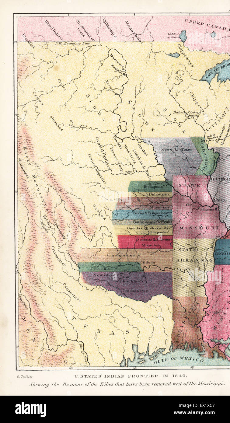 Native American or Indian Frontier in the United States in 1840, showing the positions of the Tribes that have been removed west of the Mississippi. Handcoloured lithograph from George Catlin's Manners, Customs and Condition of the North American Indians, London, 1841. Stock Photohttps://www.alamy.com/image-license-details/?v=1https://www.alamy.com/stock-photo-native-american-or-indian-frontier-in-the-united-states-in-1840-showing-84865207.html
RMEX1XC7–Native American or Indian Frontier in the United States in 1840, showing the positions of the Tribes that have been removed west of the Mississippi. Handcoloured lithograph from George Catlin's Manners, Customs and Condition of the North American Indians, London, 1841.
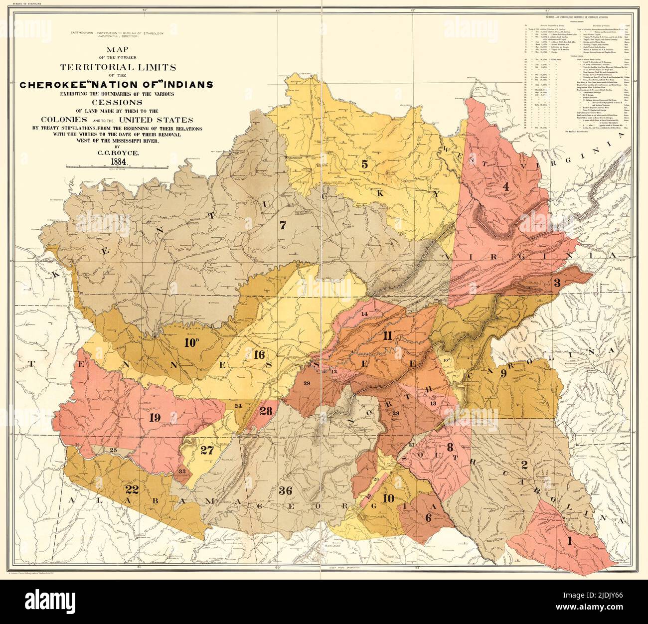 An enhanced, restored reproduction of a map of the former territorial limits of the Cherokee 'Nation of' Indians 1884. Issued by the Bureau of Ethnology of the Smithsonian Institution as noted in the corner of the map. Indicates chronology of Cherokee cessions of land. Shows ancestral lands in states east of the Mississippi. Stock Photohttps://www.alamy.com/image-license-details/?v=1https://www.alamy.com/an-enhanced-restored-reproduction-of-a-map-of-the-former-territorial-limits-of-the-cherokee-nation-of-indians-1884-issued-by-the-bureau-of-ethnology-of-the-smithsonian-institution-as-noted-in-the-corner-of-the-map-indicates-chronology-of-cherokee-cessions-of-land-shows-ancestral-lands-in-states-east-of-the-mississippi-image473086942.html
RM2JDJY66–An enhanced, restored reproduction of a map of the former territorial limits of the Cherokee 'Nation of' Indians 1884. Issued by the Bureau of Ethnology of the Smithsonian Institution as noted in the corner of the map. Indicates chronology of Cherokee cessions of land. Shows ancestral lands in states east of the Mississippi.
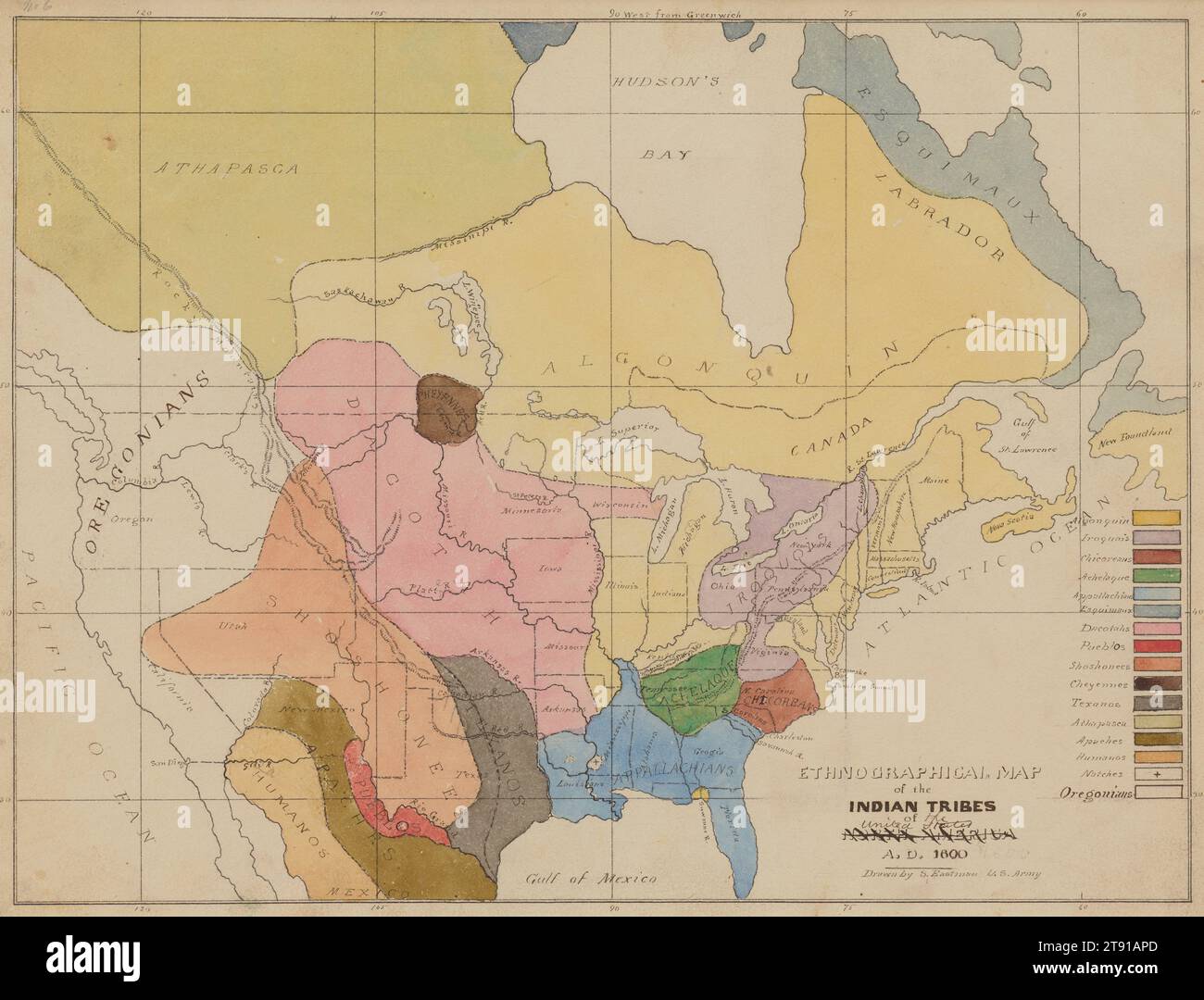 Ethnographic Map of the Indian Tribes of the United States, A.D. 1600, 1849-1855, Seth Eastman, American, 1808–1875, 9 × 12 in. (22.86 × 30.48 cm) (image)9 11/16 × 12 7/8 in. (24.61 × 32.7 cm) (sheet), Pen, ink, and watercolor, United States, 19th century, This map of Native languages is based on one by Albert Gallatin (1761-1849), a geographer and diplomat who was the first to classify these linguistic boundaries, in 1826. The vivid colors (Minnesota is pink) are especially well preserved. Map-making had always been Seth Eastman’s love. He even wrote a textbook on topographical drawing Stock Photohttps://www.alamy.com/image-license-details/?v=1https://www.alamy.com/ethnographic-map-of-the-indian-tribes-of-the-united-states-ad-1600-1849-1855-seth-eastman-american-18081875-9-12-in-2286-3048-cm-image9-1116-12-78-in-2461-327-cm-sheet-pen-ink-and-watercolor-united-states-19th-century-this-map-of-native-languages-is-based-on-one-by-albert-gallatin-1761-1849-a-geographer-and-diplomat-who-was-the-first-to-classify-these-linguistic-boundaries-in-1826-the-vivid-colors-minnesota-is-pink-are-especially-well-preserved-map-making-had-always-been-seth-eastmans-love-he-even-wrote-a-textbook-on-topographical-drawing-image573504469.html
RM2T91APD–Ethnographic Map of the Indian Tribes of the United States, A.D. 1600, 1849-1855, Seth Eastman, American, 1808–1875, 9 × 12 in. (22.86 × 30.48 cm) (image)9 11/16 × 12 7/8 in. (24.61 × 32.7 cm) (sheet), Pen, ink, and watercolor, United States, 19th century, This map of Native languages is based on one by Albert Gallatin (1761-1849), a geographer and diplomat who was the first to classify these linguistic boundaries, in 1826. The vivid colors (Minnesota is pink) are especially well preserved. Map-making had always been Seth Eastman’s love. He even wrote a textbook on topographical drawing
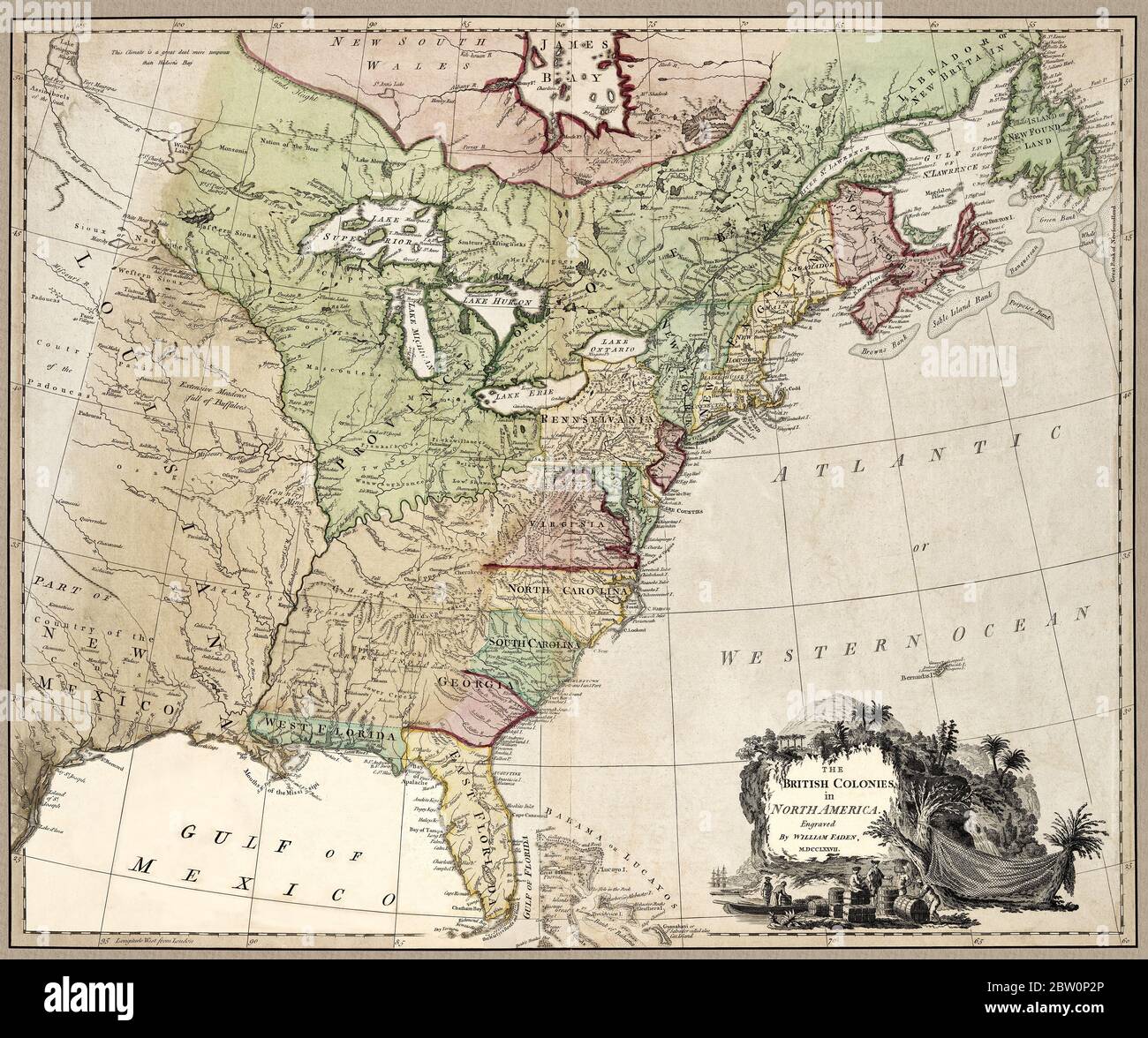 'The British colonies in North America.' Map shows important landmarks of the North American continent at about the time of the American Revolution. The British had 15 colonies at about that time in North America--not 13. Note that the 14th and 15th British North American Colonies are included: West Florida and East Florida. The New England colonies are clustered together under the name New England. Map also notes Indian areas. This is a beautifully detailed historic map reproduction. Original from a British atlas published by famed cartographer William Faden was created circa 1777. Stock Photohttps://www.alamy.com/image-license-details/?v=1https://www.alamy.com/the-british-colonies-in-north-america-map-shows-important-landmarks-of-the-north-american-continent-at-about-the-time-of-the-american-revolution-the-british-had-15-colonies-at-about-that-time-in-north-america-not-13-note-that-the-14th-and-15th-british-north-american-colonies-are-included-west-florida-and-east-florida-the-new-england-colonies-are-clustered-together-under-the-name-new-england-map-also-notes-indian-areas-this-is-a-beautifully-detailed-historic-map-reproduction-original-from-a-british-atlas-published-by-famed-cartographer-william-faden-was-created-circa-1777-image359591086.html
RM2BW0P2P–'The British colonies in North America.' Map shows important landmarks of the North American continent at about the time of the American Revolution. The British had 15 colonies at about that time in North America--not 13. Note that the 14th and 15th British North American Colonies are included: West Florida and East Florida. The New England colonies are clustered together under the name New England. Map also notes Indian areas. This is a beautifully detailed historic map reproduction. Original from a British atlas published by famed cartographer William Faden was created circa 1777.
 Native American or Indian Frontier in the United States in 1840, showing the positions of the Tribes that have been removed west of the Missisippi. Handcoloured lithograph from George Catlin's Manners, Customs and Condition of the North American Indians, London, 1841. Stock Photohttps://www.alamy.com/image-license-details/?v=1https://www.alamy.com/native-american-or-indian-frontier-in-the-united-states-in-1840-showing-the-positions-of-the-tribes-that-have-been-removed-west-of-the-missisippi-handcoloured-lithograph-from-george-catlins-manners-customs-and-condition-of-the-north-american-indians-london-1841-image211129990.html
RMP7DPCP–Native American or Indian Frontier in the United States in 1840, showing the positions of the Tribes that have been removed west of the Missisippi. Handcoloured lithograph from George Catlin's Manners, Customs and Condition of the North American Indians, London, 1841.
![[Whole map] Map of Native Indian lands. Sketch map, probably copied from a Native Indian map, illustrating with diagrams the areas occupied by the different tribes near Charlestown [Charleston], in the north-west of South Carolina. Presented to Francis Nicholson, Governor of South Carolina, who dedicated it to George, Prince of Wales. N. America [South Carolina]; circa 1721-1725. Source: Sloane 4723,. Language: English. Stock Photo [Whole map] Map of Native Indian lands. Sketch map, probably copied from a Native Indian map, illustrating with diagrams the areas occupied by the different tribes near Charlestown [Charleston], in the north-west of South Carolina. Presented to Francis Nicholson, Governor of South Carolina, who dedicated it to George, Prince of Wales. N. America [South Carolina]; circa 1721-1725. Source: Sloane 4723,. Language: English. Stock Photo](https://c8.alamy.com/comp/R588RY/whole-map-map-of-native-indian-lands-sketch-map-probably-copied-from-a-native-indian-map-illustrating-with-diagrams-the-areas-occupied-by-the-different-tribes-near-charlestown-charleston-in-the-north-west-of-south-carolina-presented-to-francis-nicholson-governor-of-south-carolina-who-dedicated-it-to-george-prince-of-wales-n-america-south-carolina-circa-1721-1725-source-sloane-4723-language-english-R588RY.jpg) [Whole map] Map of Native Indian lands. Sketch map, probably copied from a Native Indian map, illustrating with diagrams the areas occupied by the different tribes near Charlestown [Charleston], in the north-west of South Carolina. Presented to Francis Nicholson, Governor of South Carolina, who dedicated it to George, Prince of Wales. N. America [South Carolina]; circa 1721-1725. Source: Sloane 4723,. Language: English. Stock Photohttps://www.alamy.com/image-license-details/?v=1https://www.alamy.com/whole-map-map-of-native-indian-lands-sketch-map-probably-copied-from-a-native-indian-map-illustrating-with-diagrams-the-areas-occupied-by-the-different-tribes-near-charlestown-charleston-in-the-north-west-of-south-carolina-presented-to-francis-nicholson-governor-of-south-carolina-who-dedicated-it-to-george-prince-of-wales-n-america-south-carolina-circa-1721-1725-source-sloane-4723-language-english-image226990623.html
[Whole map] Map of Native Indian lands. Sketch map, probably copied from a Native Indian map, illustrating with diagrams the areas occupied by the different tribes near Charlestown [Charleston], in the north-west of South Carolina. Presented to Francis Nicholson, Governor of South Carolina, who dedicated it to George, Prince of Wales. N. America [South Carolina]; circa 1721-1725. Source: Sloane 4723,. Language: English. Stock Photohttps://www.alamy.com/image-license-details/?v=1https://www.alamy.com/whole-map-map-of-native-indian-lands-sketch-map-probably-copied-from-a-native-indian-map-illustrating-with-diagrams-the-areas-occupied-by-the-different-tribes-near-charlestown-charleston-in-the-north-west-of-south-carolina-presented-to-francis-nicholson-governor-of-south-carolina-who-dedicated-it-to-george-prince-of-wales-n-america-south-carolina-circa-1721-1725-source-sloane-4723-language-english-image226990623.htmlRMR588RY–[Whole map] Map of Native Indian lands. Sketch map, probably copied from a Native Indian map, illustrating with diagrams the areas occupied by the different tribes near Charlestown [Charleston], in the north-west of South Carolina. Presented to Francis Nicholson, Governor of South Carolina, who dedicated it to George, Prince of Wales. N. America [South Carolina]; circa 1721-1725. Source: Sloane 4723,. Language: English.
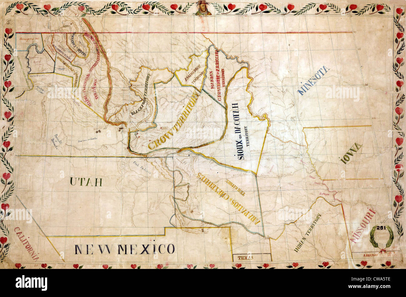 1851 map of the upper Great Plains and Rocky Mountains region shows territories of various North American Indian tribes. Stock Photohttps://www.alamy.com/image-license-details/?v=1https://www.alamy.com/stock-photo-1851-map-of-the-upper-great-plains-and-rocky-mountains-region-shows-50011262.html
RMCWA5TE–1851 map of the upper Great Plains and Rocky Mountains region shows territories of various North American Indian tribes.
 Indian Reservations west of the Mississippi River, 1923. This map, created by the Office of Indian Affairs in 1923, shows the location of Indian reservations west of the Mississippi River. The names of the tribes are given and important geographic features such as state boundaries and rivers and railways are shown. Reservation schools and hospitals are also marked. In 1924, Congress passed the Indian Citizenship Act, which granted citizenship rights to Native Americans. Stock Photohttps://www.alamy.com/image-license-details/?v=1https://www.alamy.com/indian-reservations-west-of-the-mississippi-river-1923-this-map-created-by-the-office-of-indian-affairs-in-1923-shows-the-location-of-indian-reservations-west-of-the-mississippi-river-the-names-of-the-tribes-are-given-and-important-geographic-features-such-as-state-boundaries-and-rivers-and-railways-are-shown-reservation-schools-and-hospitals-are-also-marked-in-1924-congress-passed-the-indian-citizenship-act-which-granted-citizenship-rights-to-native-americans-image595002992.html
RM2WG0MAT–Indian Reservations west of the Mississippi River, 1923. This map, created by the Office of Indian Affairs in 1923, shows the location of Indian reservations west of the Mississippi River. The names of the tribes are given and important geographic features such as state boundaries and rivers and railways are shown. Reservation schools and hospitals are also marked. In 1924, Congress passed the Indian Citizenship Act, which granted citizenship rights to Native Americans.
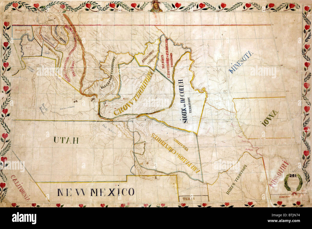 1851 map of the upper Great Plains and Rocky Mountains region shows territories of various North American Indian tribes. Stock Photohttps://www.alamy.com/image-license-details/?v=1https://www.alamy.com/stock-photo-1851-map-of-the-upper-great-plains-and-rocky-mountains-region-shows-32373912.html
RMBTJN74–1851 map of the upper Great Plains and Rocky Mountains region shows territories of various North American Indian tribes.
 Map of Nebraska and Kansas Territories, showing the location of the Indian Reserves according to the treaties of 1854. Stock Photohttps://www.alamy.com/image-license-details/?v=1https://www.alamy.com/stock-image-map-of-nebraska-and-kansas-territories-showing-the-location-of-the-168572047.html
RMKP73A7–Map of Nebraska and Kansas Territories, showing the location of the Indian Reserves according to the treaties of 1854.
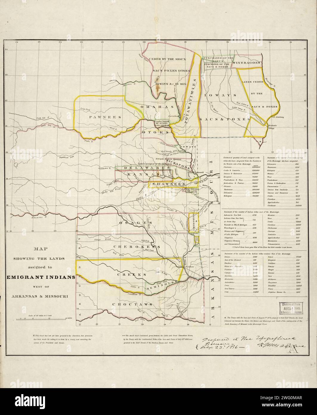 Map showing the lands assigned to emigrant Indians west of Arkansas and Missouri, 1836. Following passage of the Indian Removal Act in 1830, President Andrew Jackson implemented a policy of land exchanges and forced expulsion of the eastern Native Americans to regions west of the Mississippi River. It shows the approximate boundaries of the lands assigned to the relocated tribes in territories west of the Mississippi by 1836. Different shades of color are used to indicate the various tribes. The map also shows the southwestern border of the United States with Mexico, which at that time inclu Stock Photohttps://www.alamy.com/image-license-details/?v=1https://www.alamy.com/map-showing-the-lands-assigned-to-emigrant-indians-west-of-arkansas-and-missouri-1836-following-passage-of-the-indian-removal-act-in-1830-president-andrew-jackson-implemented-a-policy-of-land-exchanges-and-forced-expulsion-of-the-eastern-native-americans-to-regions-west-of-the-mississippi-river-it-shows-the-approximate-boundaries-of-the-lands-assigned-to-the-relocated-tribes-in-territories-west-of-the-mississippi-by-1836-different-shades-of-color-are-used-to-indicate-the-various-tribes-the-map-also-shows-the-southwestern-border-of-the-united-states-with-mexico-which-at-that-time-inclu-image595002991.html
RM2WG0MAR–Map showing the lands assigned to emigrant Indians west of Arkansas and Missouri, 1836. Following passage of the Indian Removal Act in 1830, President Andrew Jackson implemented a policy of land exchanges and forced expulsion of the eastern Native Americans to regions west of the Mississippi River. It shows the approximate boundaries of the lands assigned to the relocated tribes in territories west of the Mississippi by 1836. Different shades of color are used to indicate the various tribes. The map also shows the southwestern border of the United States with Mexico, which at that time inclu