Quick filters:
Peninsular war map Stock Photos and Images
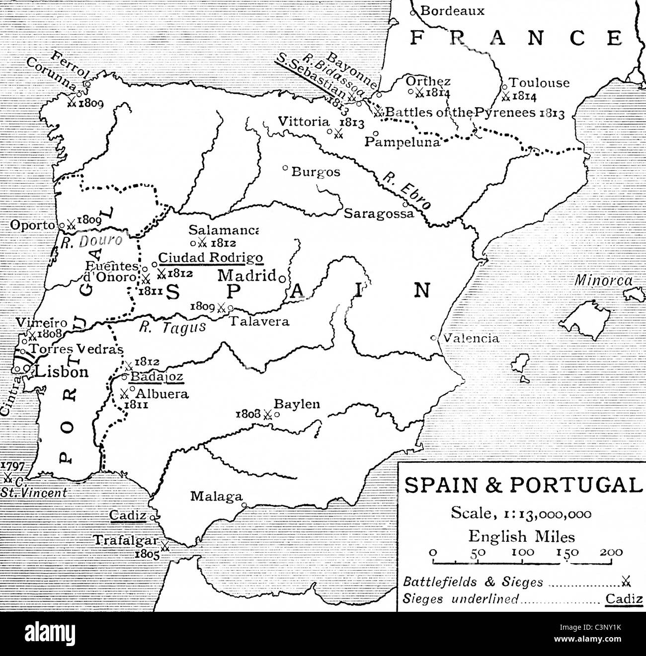 Map of Spain and Portugal at the time of The Peninsular War. From The Story of England, published 1930. Stock Photohttps://www.alamy.com/image-license-details/?v=1https://www.alamy.com/stock-photo-map-of-spain-and-portugal-at-the-time-of-the-peninsular-war-from-the-36746911.html
RMC3NY1K–Map of Spain and Portugal at the time of The Peninsular War. From The Story of England, published 1930.
 'Map of the Spanish Campaign', c1807-1814, (1896). Artist: Unknown. Stock Photohttps://www.alamy.com/image-license-details/?v=1https://www.alamy.com/map-of-the-spanish-campaign-c1807-1814-1896-artist-unknown-image211841702.html
RMP8J672–'Map of the Spanish Campaign', c1807-1814, (1896). Artist: Unknown.
 Napoleonic map. City of Badajoz, Extremadura, Spain. Peninsular War. Badajoz was sieged four times between 1811 and 1812 (Napoleonic Wars). Atlas de l'Histoire du Consulat et de l'Empire History of the Consulate and the Empire of France under Napoleon by Marie Joseph Louis Adolphe Thiers (1797-1877). Drawings by Dufour, engravings by Dyonnet. Edited in Paris, 1864. Stock Photohttps://www.alamy.com/image-license-details/?v=1https://www.alamy.com/napoleonic-map-city-of-badajoz-extremadura-spain-peninsular-war-badajoz-was-sieged-four-times-between-1811-and-1812-napoleonic-wars-atlas-de-lhistoire-du-consulat-et-de-lempire-history-of-the-consulate-and-the-empire-of-france-under-napoleon-by-marie-joseph-louis-adolphe-thiers-1797-1877-drawings-by-dufour-engravings-by-dyonnet-edited-in-paris-1864-image231501219.html
RMRCHP4K–Napoleonic map. City of Badajoz, Extremadura, Spain. Peninsular War. Badajoz was sieged four times between 1811 and 1812 (Napoleonic Wars). Atlas de l'Histoire du Consulat et de l'Empire History of the Consulate and the Empire of France under Napoleon by Marie Joseph Louis Adolphe Thiers (1797-1877). Drawings by Dufour, engravings by Dyonnet. Edited in Paris, 1864.
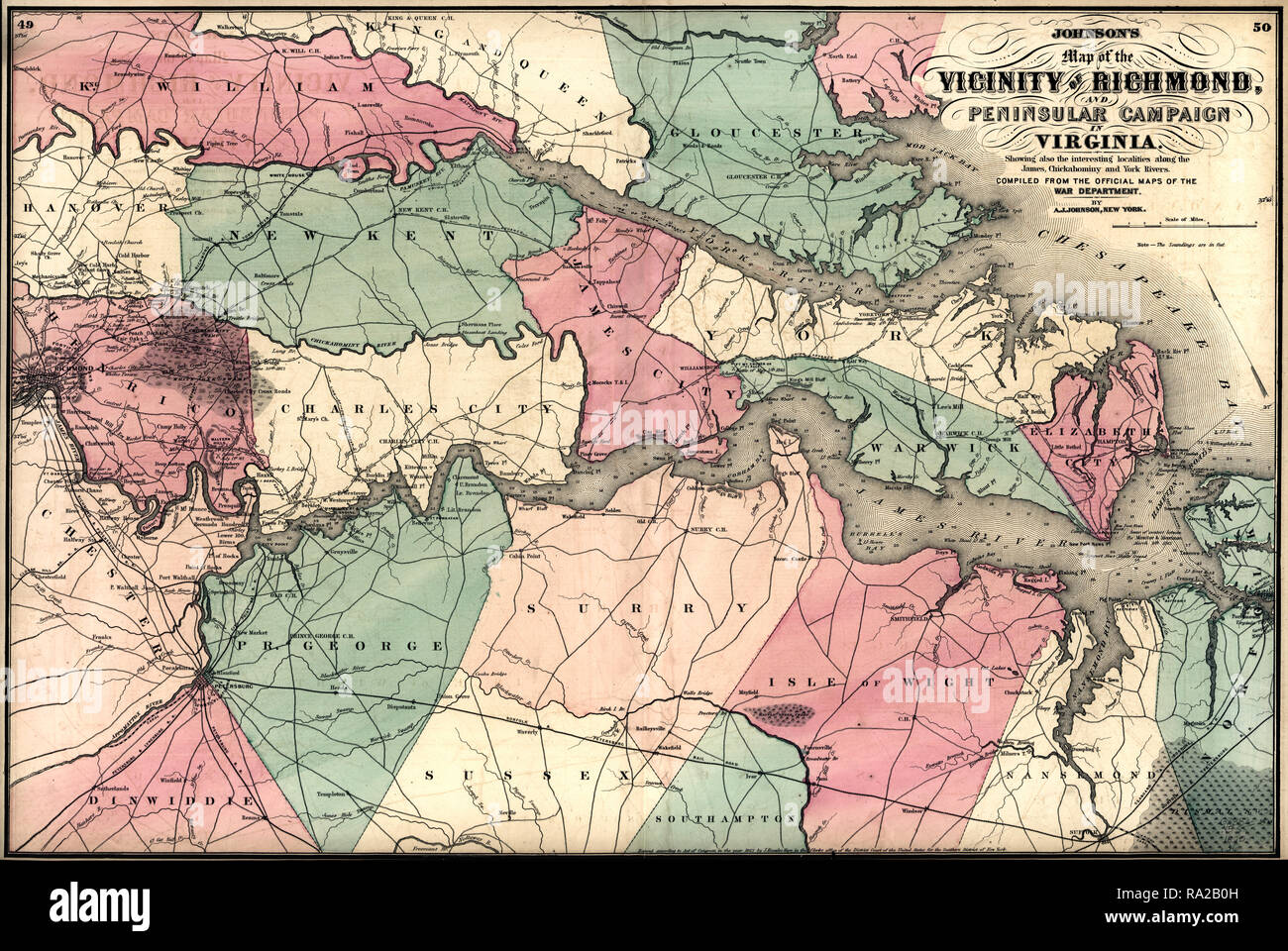 Johnson's map of the vicinity of Richmond, and Peninsular Campaign in Virginia : showing also the interesting localities along the James, Chickahominy and York rivers. 1862 Stock Photohttps://www.alamy.com/image-license-details/?v=1https://www.alamy.com/johnsons-map-of-the-vicinity-of-richmond-and-peninsular-campaign-in-virginia-showing-also-the-interesting-localities-along-the-james-chickahominy-and-york-rivers-1862-image229933889.html
RMRA2B0H–Johnson's map of the vicinity of Richmond, and Peninsular Campaign in Virginia : showing also the interesting localities along the James, Chickahominy and York rivers. 1862
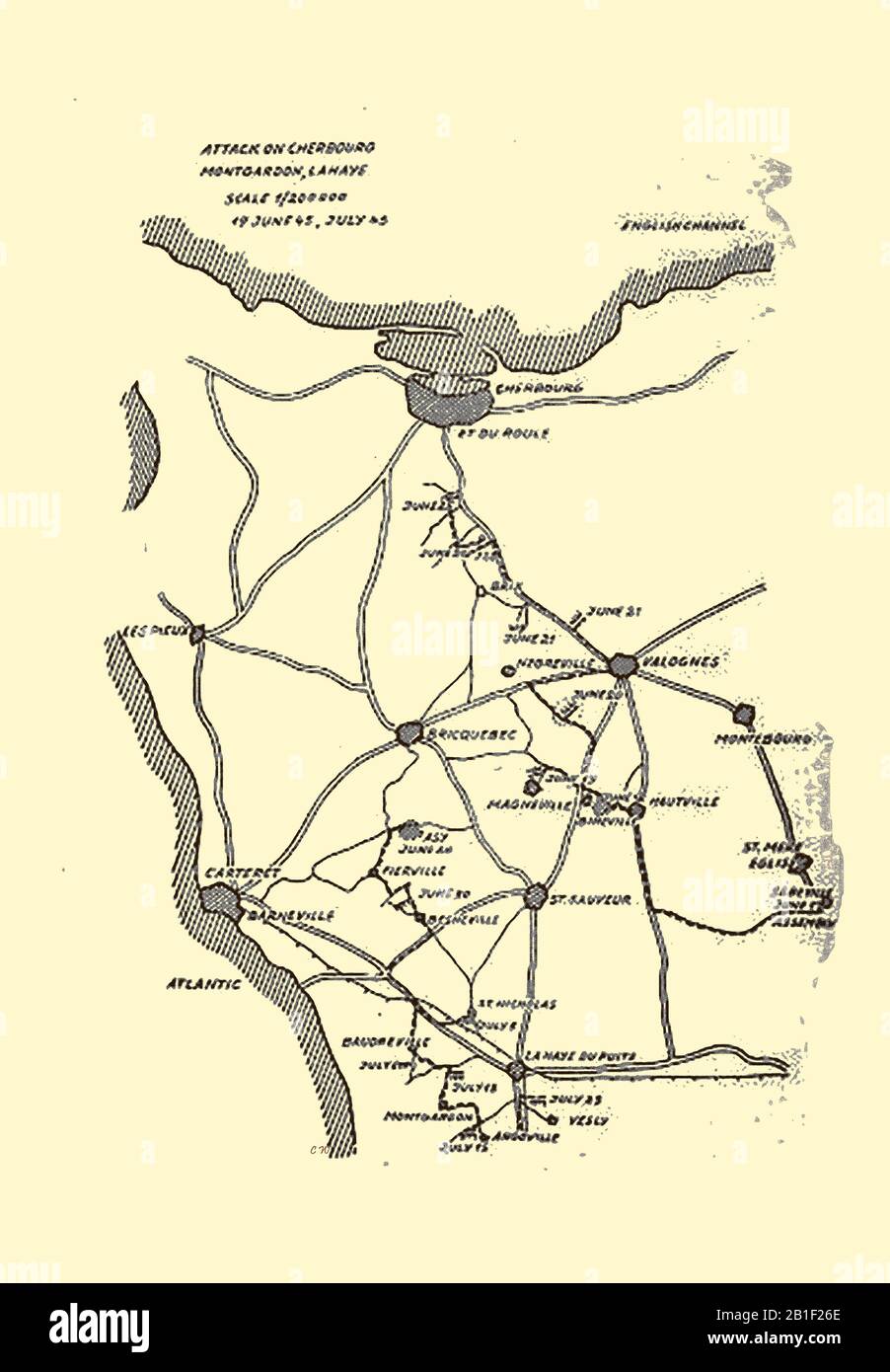 World War II battle sketch map. The Attack on Cherbourg June-July 1945, (part of the Battle of Normandy) Stock Photohttps://www.alamy.com/image-license-details/?v=1https://www.alamy.com/world-war-ii-battle-sketch-map-the-attack-on-cherbourg-june-july-1945-part-of-the-battle-of-normandy-image345153046.html
RM2B1F26E–World War II battle sketch map. The Attack on Cherbourg June-July 1945, (part of the Battle of Normandy)
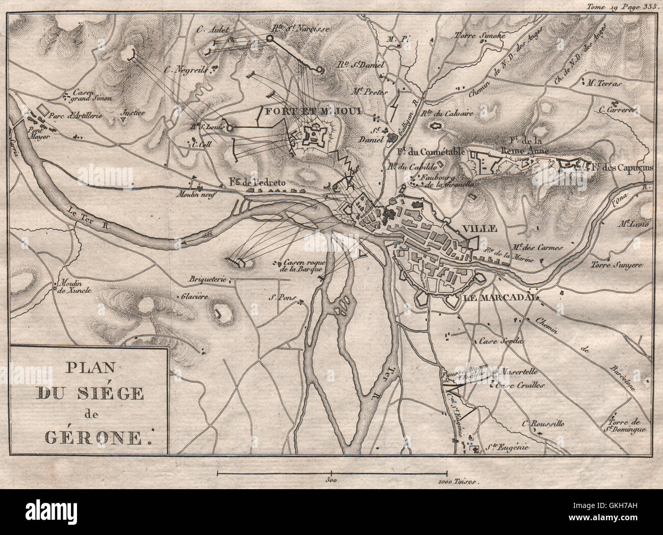 Siege of Gerona. Peninsular War. 1808-9. Spain, 1820 antique map Stock Photohttps://www.alamy.com/image-license-details/?v=1https://www.alamy.com/stock-photo-siege-of-gerona-peninsular-war-1808-9-spain-1820-antique-map-115319641.html
RFGKH7AH–Siege of Gerona. Peninsular War. 1808-9. Spain, 1820 antique map
 Sketch map Battle of Rolica 1808 Stock Photohttps://www.alamy.com/image-license-details/?v=1https://www.alamy.com/stock-photo-sketch-map-battle-of-rolica-1808-90256692.html
RMF6RF98–Sketch map Battle of Rolica 1808
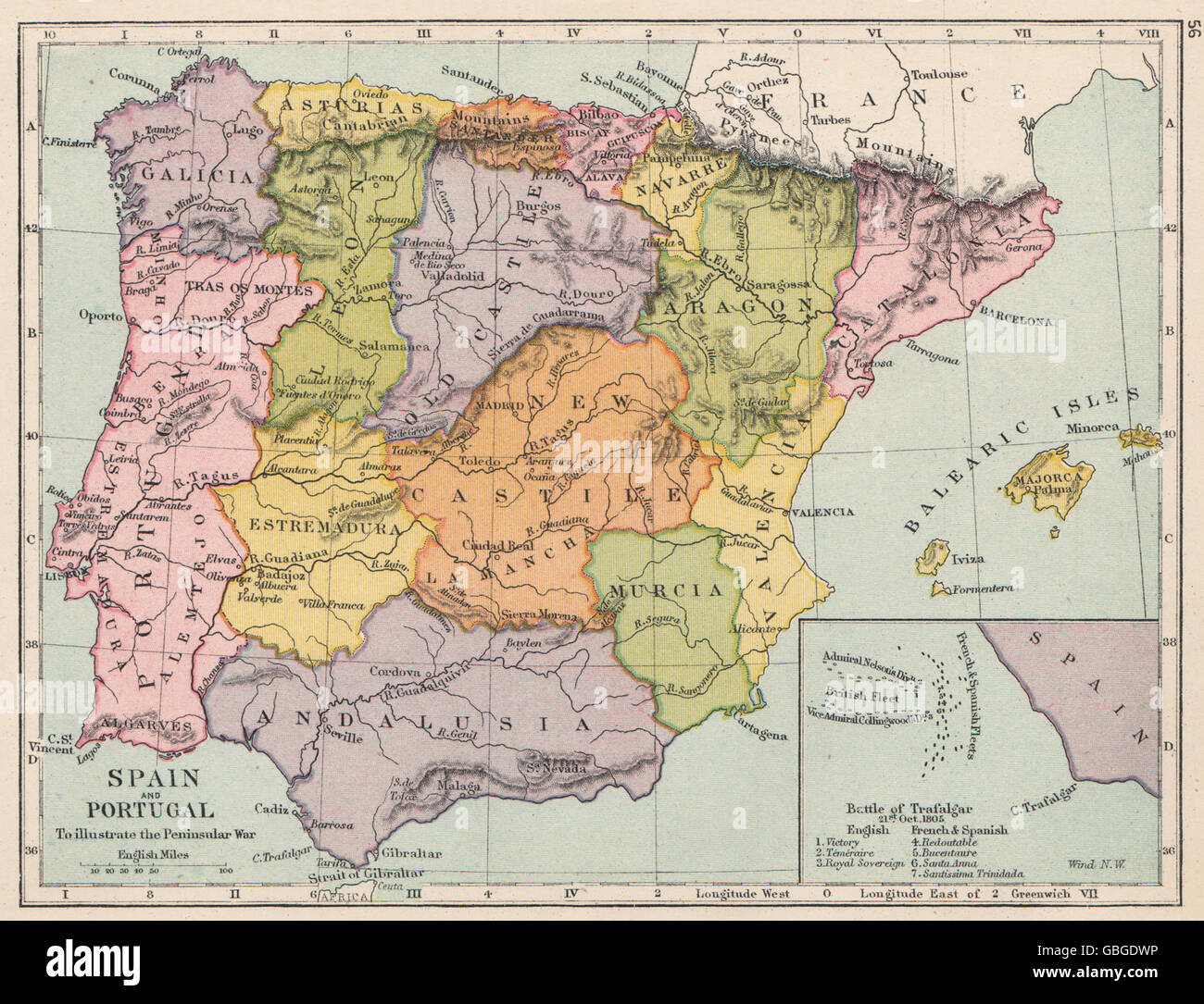 PENINSULAR WAR: Spain & Portugal showing battlefields. Inset Trafalgar, 1907 map Stock Photohttps://www.alamy.com/image-license-details/?v=1https://www.alamy.com/stock-photo-peninsular-war-spain-portugal-showing-battlefields-inset-trafalgar-110385570.html
RFGBGDWP–PENINSULAR WAR: Spain & Portugal showing battlefields. Inset Trafalgar, 1907 map
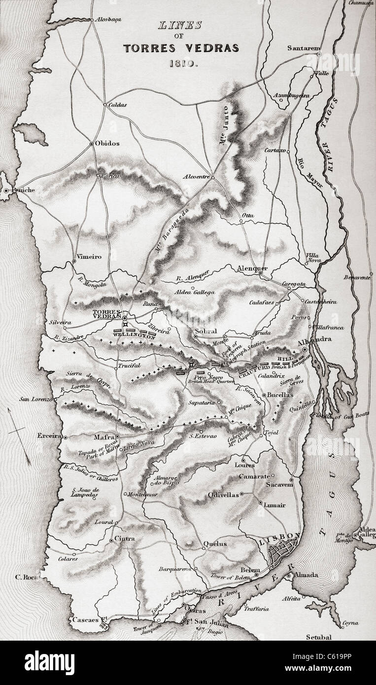 Map of the Lines of Torres Vedras, Portugal, 1810. Stock Photohttps://www.alamy.com/image-license-details/?v=1https://www.alamy.com/stock-photo-map-of-the-lines-of-torres-vedras-portugal-1810-38138318.html
RMC619PP–Map of the Lines of Torres Vedras, Portugal, 1810.
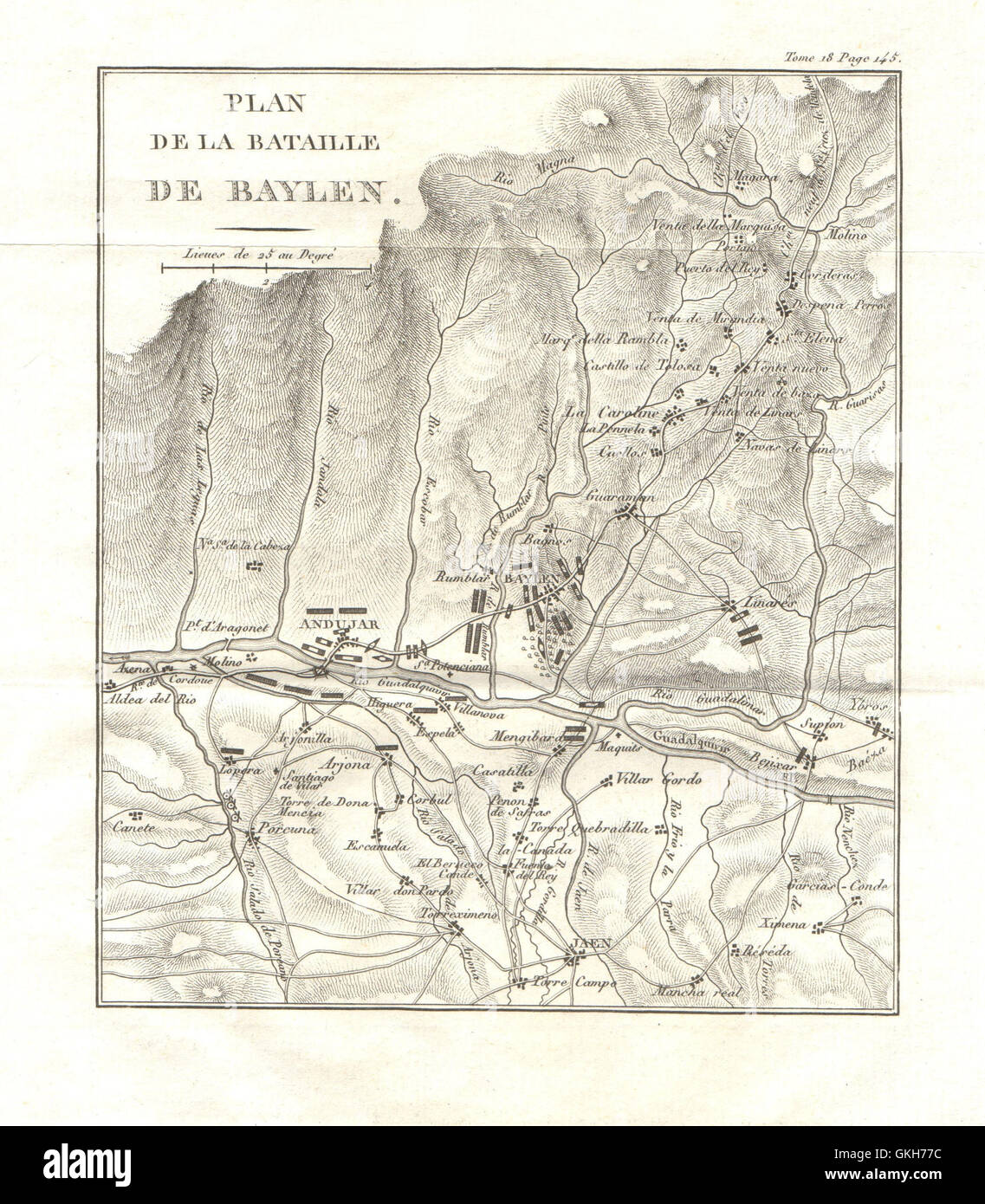 Battle of Bailén (Bailen/Baylen) 1808. Peninsular War. Spain, 1820 antique map Stock Photohttps://www.alamy.com/image-license-details/?v=1https://www.alamy.com/stock-photo-battle-of-bailn-bailenbaylen-1808-peninsular-war-spain-1820-antique-115319552.html
RFGKH77C–Battle of Bailén (Bailen/Baylen) 1808. Peninsular War. Spain, 1820 antique map
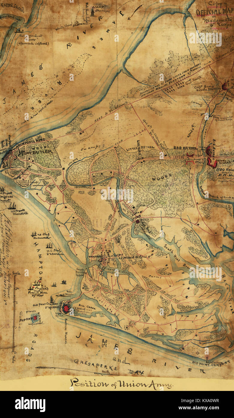 Official map of the Union works in front of Yorktown, Va. Stock Photohttps://www.alamy.com/image-license-details/?v=1https://www.alamy.com/stock-photo-official-map-of-the-union-works-in-front-of-yorktown-va-171094611.html
RMKXA0WR–Official map of the Union works in front of Yorktown, Va.
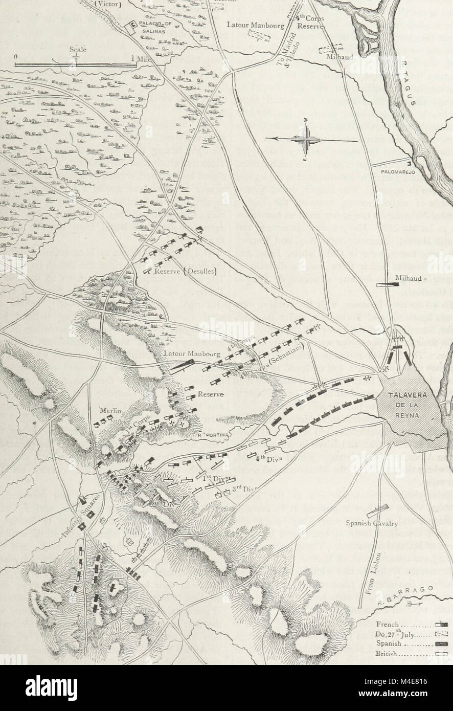 A map of the final French attack of the Battle of Talavera, July 1809 Stock Photohttps://www.alamy.com/image-license-details/?v=1https://www.alamy.com/stock-photo-a-map-of-the-final-french-attack-of-the-battle-of-talavera-july-1809-174875938.html
RMM4E816–A map of the final French attack of the Battle of Talavera, July 1809
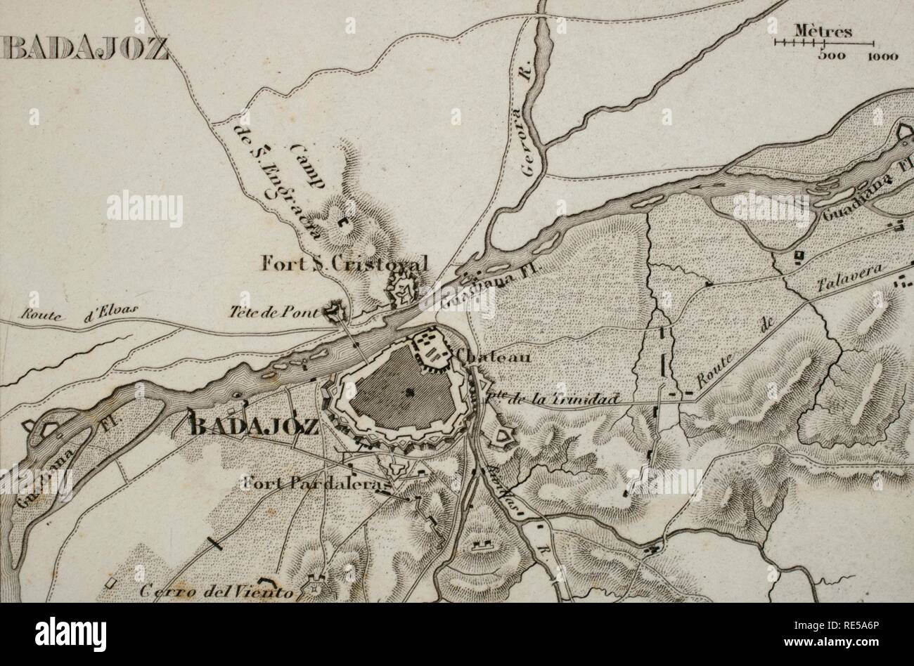 Napoleonic map. City of Badajoz, Extremadura, Spain. Peninsular War. Badajoz was sieged four times between 1811 and 1812 (Napoleonic Wars). Atlas de l'Histoire du Consulat et de l'Empire History of the Consulate and the Empire of France under Napoleon by Marie Joseph Louis Adolphe Thiers (1797-1877). Drawings by Dufour, engravings by Dyonnet. Edited in Paris, 1864. Stock Photohttps://www.alamy.com/image-license-details/?v=1https://www.alamy.com/napoleonic-map-city-of-badajoz-extremadura-spain-peninsular-war-badajoz-was-sieged-four-times-between-1811-and-1812-napoleonic-wars-atlas-de-lhistoire-du-consulat-et-de-lempire-history-of-the-consulate-and-the-empire-of-france-under-napoleon-by-marie-joseph-louis-adolphe-thiers-1797-1877-drawings-by-dufour-engravings-by-dyonnet-edited-in-paris-1864-image232457758.html
RMRE5A6P–Napoleonic map. City of Badajoz, Extremadura, Spain. Peninsular War. Badajoz was sieged four times between 1811 and 1812 (Napoleonic Wars). Atlas de l'Histoire du Consulat et de l'Empire History of the Consulate and the Empire of France under Napoleon by Marie Joseph Louis Adolphe Thiers (1797-1877). Drawings by Dufour, engravings by Dyonnet. Edited in Paris, 1864.
 The Battle of Orthez on 27 February 1814, southern France, Peninsular War, From British Battles on Land and Sea, by James Grant Stock Photohttps://www.alamy.com/image-license-details/?v=1https://www.alamy.com/the-battle-of-orthez-on-27-february-1814-southern-france-peninsular-war-from-british-battles-on-land-and-sea-by-james-grant-image401811708.html
RM2E9M2X4–The Battle of Orthez on 27 February 1814, southern France, Peninsular War, From British Battles on Land and Sea, by James Grant
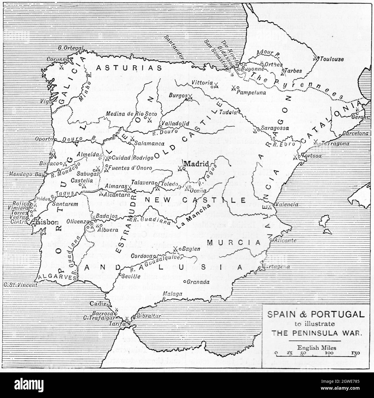 B&W Illustration; Map of Spain and Portugal to Illustrate the Peninsular War 1807 - 1814 Stock Photohttps://www.alamy.com/image-license-details/?v=1https://www.alamy.com/bw-illustration-map-of-spain-and-portugal-to-illustrate-the-peninsular-war-1807-1814-image445938645.html
RM2GWE785–B&W Illustration; Map of Spain and Portugal to Illustrate the Peninsular War 1807 - 1814
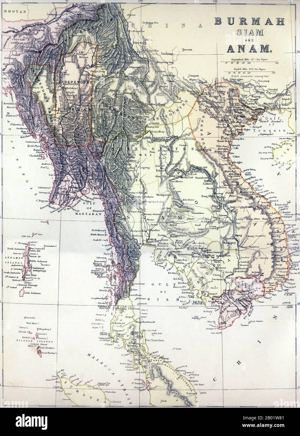 Southeast Asia: 'Burmah, Siam and Anam'. Map of Greater Indochina and the western part of the Malay-Indonesian Archipelago, 1886. A political map of mainland Southeast Asia including Burma, Thailand, Laos, Cambodia and Vietnam, as well as peninsular Malaysia, the Andaman and Nicobar Islands, and part of Sumatra Published, apparently, just before the 3rd Anglo-Burmese War (1885-1886) which would extinguish Burmese independence, it shows 'Independent Burma' in an approximate rectangle around Mandalay. To the east lies the 'Independent Shan Country' encompassing the Burmese Shan States. Stock Photohttps://www.alamy.com/image-license-details/?v=1https://www.alamy.com/southeast-asia-burmah-siam-and-anam-map-of-greater-indochina-and-the-western-part-of-the-malay-indonesian-archipelago-1886-a-political-map-of-mainland-southeast-asia-including-burma-thailand-laos-cambodia-and-vietnam-as-well-as-peninsular-malaysia-the-andaman-and-nicobar-islands-and-part-of-sumatra-published-apparently-just-before-the-3rd-anglo-burmese-war-1885-1886-which-would-extinguish-burmese-independence-it-shows-independent-burma-in-an-approximate-rectangle-around-mandalay-to-the-east-lies-the-independent-shan-country-encompassing-the-burmese-shan-states-image344249137.html
RM2B01W81–Southeast Asia: 'Burmah, Siam and Anam'. Map of Greater Indochina and the western part of the Malay-Indonesian Archipelago, 1886. A political map of mainland Southeast Asia including Burma, Thailand, Laos, Cambodia and Vietnam, as well as peninsular Malaysia, the Andaman and Nicobar Islands, and part of Sumatra Published, apparently, just before the 3rd Anglo-Burmese War (1885-1886) which would extinguish Burmese independence, it shows 'Independent Burma' in an approximate rectangle around Mandalay. To the east lies the 'Independent Shan Country' encompassing the Burmese Shan States.
 April 21, 2018-Seoul, South Korea-People walk by a banner showing a map of the Korean peninsular to wish for a successful inter-Korean summit on April 21, 2018 in Seoul, South Korea. The inter-Korean summit is scheduled on April 27, 2018 at the Joint Security Area in Panmunjom, agreed by South Korean President Moon Jae-in and North Korea's leader Kim Jong-un. Stock Photohttps://www.alamy.com/image-license-details/?v=1https://www.alamy.com/april-21-2018-seoul-south-korea-people-walk-by-a-banner-showing-a-map-of-the-korean-peninsular-to-wish-for-a-successful-inter-korean-summit-on-april-21-2018-in-seoul-south-korea-the-inter-korean-summit-is-scheduled-on-april-27-2018-at-the-joint-security-area-in-panmunjom-agreed-by-south-korean-president-moon-jae-in-and-north-koreas-leader-kim-jong-un-image432921515.html
RM2G497PK–April 21, 2018-Seoul, South Korea-People walk by a banner showing a map of the Korean peninsular to wish for a successful inter-Korean summit on April 21, 2018 in Seoul, South Korea. The inter-Korean summit is scheduled on April 27, 2018 at the Joint Security Area in Panmunjom, agreed by South Korean President Moon Jae-in and North Korea's leader Kim Jong-un.
 . English: This is a rare and important 1862 map of the Vicinity of Richmond during the civil war by A. J. Johnson. Shows the Union Advance during the Peninsular Campaign of the American Civil war. Also includes considerable detail ranging from soundings to individual buildings, wells, and bridges. It is extremely rare to find this map in good condition as it fully occupied its page in the Johnson’s atlas, lacking space for substantial borders. Consequently any edge damage, common in old Johnson atlases, invariably severely impacted the map itself. Map is dated and copyrighted “Entered accord Stock Photohttps://www.alamy.com/image-license-details/?v=1https://www.alamy.com/english-this-is-a-rare-and-important-1862-map-of-the-vicinity-of-richmond-during-the-civil-war-by-a-j-johnson-shows-the-union-advance-during-the-peninsular-campaign-of-the-american-civil-war-also-includes-considerable-detail-ranging-from-soundings-to-individual-buildings-wells-and-bridges-it-is-extremely-rare-to-find-this-map-in-good-condition-as-it-fully-occupied-its-page-in-the-johnsons-atlas-lacking-space-for-substantial-borders-consequently-any-edge-damage-common-in-old-johnson-atlases-invariably-severely-impacted-the-map-itself-map-is-dated-and-copyrighted-entered-accord-image184964644.html
RMMMWT84–. English: This is a rare and important 1862 map of the Vicinity of Richmond during the civil war by A. J. Johnson. Shows the Union Advance during the Peninsular Campaign of the American Civil war. Also includes considerable detail ranging from soundings to individual buildings, wells, and bridges. It is extremely rare to find this map in good condition as it fully occupied its page in the Johnson’s atlas, lacking space for substantial borders. Consequently any edge damage, common in old Johnson atlases, invariably severely impacted the map itself. Map is dated and copyrighted “Entered accord
 Bacon's map of the vicinity of Richmond, and Peninsular Campaign in Virginia : showing also the interesting localities along the James, Chickahominy and York Rivers. Relief shown by hachures. Inset: A General Map of the Seat of War.... , Virginia , Richmond Stock Photohttps://www.alamy.com/image-license-details/?v=1https://www.alamy.com/bacons-map-of-the-vicinity-of-richmond-and-peninsular-campaign-in-virginia-showing-also-the-interesting-localities-along-the-james-chickahominy-and-york-rivers-relief-shown-by-hachures-inset-a-general-map-of-the-seat-of-war-virginia-richmond-image502713535.html
RM2M5TG6R–Bacon's map of the vicinity of Richmond, and Peninsular Campaign in Virginia : showing also the interesting localities along the James, Chickahominy and York Rivers. Relief shown by hachures. Inset: A General Map of the Seat of War.... , Virginia , Richmond
![A map of Johore and Singapore reproduced 1942, from a map compiled and drawn at the war office 1934. Johore & Singapore half tones, Series MDR 570. [Cairo] : [Survey Directorate, Middle East], 1942. Great Britain. Army. Royal Engineers. Field Survey Company, 512th. Scale 1:250 000. Source: Maps MOD MDR 570 South sheet. Stock Photo A map of Johore and Singapore reproduced 1942, from a map compiled and drawn at the war office 1934. Johore & Singapore half tones, Series MDR 570. [Cairo] : [Survey Directorate, Middle East], 1942. Great Britain. Army. Royal Engineers. Field Survey Company, 512th. Scale 1:250 000. Source: Maps MOD MDR 570 South sheet. Stock Photo](https://c8.alamy.com/comp/R56HWD/a-map-of-johore-and-singapore-reproduced-1942-from-a-map-compiled-and-drawn-at-the-war-office-1934-johore-singapore-half-tones-series-mdr-570-cairo-survey-directorate-middle-east-1942-great-britain-army-royal-engineers-field-survey-company-512th-scale-1250-000-source-maps-mod-mdr-570-south-sheet-R56HWD.jpg) A map of Johore and Singapore reproduced 1942, from a map compiled and drawn at the war office 1934. Johore & Singapore half tones, Series MDR 570. [Cairo] : [Survey Directorate, Middle East], 1942. Great Britain. Army. Royal Engineers. Field Survey Company, 512th. Scale 1:250 000. Source: Maps MOD MDR 570 South sheet. Stock Photohttps://www.alamy.com/image-license-details/?v=1https://www.alamy.com/a-map-of-johore-and-singapore-reproduced-1942-from-a-map-compiled-and-drawn-at-the-war-office-1934-johore-singapore-half-tones-series-mdr-570-cairo-survey-directorate-middle-east-1942-great-britain-army-royal-engineers-field-survey-company-512th-scale-1250-000-source-maps-mod-mdr-570-south-sheet-image226953817.html
A map of Johore and Singapore reproduced 1942, from a map compiled and drawn at the war office 1934. Johore & Singapore half tones, Series MDR 570. [Cairo] : [Survey Directorate, Middle East], 1942. Great Britain. Army. Royal Engineers. Field Survey Company, 512th. Scale 1:250 000. Source: Maps MOD MDR 570 South sheet. Stock Photohttps://www.alamy.com/image-license-details/?v=1https://www.alamy.com/a-map-of-johore-and-singapore-reproduced-1942-from-a-map-compiled-and-drawn-at-the-war-office-1934-johore-singapore-half-tones-series-mdr-570-cairo-survey-directorate-middle-east-1942-great-britain-army-royal-engineers-field-survey-company-512th-scale-1250-000-source-maps-mod-mdr-570-south-sheet-image226953817.htmlRMR56HWD–A map of Johore and Singapore reproduced 1942, from a map compiled and drawn at the war office 1934. Johore & Singapore half tones, Series MDR 570. [Cairo] : [Survey Directorate, Middle East], 1942. Great Britain. Army. Royal Engineers. Field Survey Company, 512th. Scale 1:250 000. Source: Maps MOD MDR 570 South sheet.
 Replica of a camp during historical recreation of 'Los Sitios', the events that took place in Zaragoza, Spain, during the Peninsular War in the early Stock Photohttps://www.alamy.com/image-license-details/?v=1https://www.alamy.com/replica-of-a-camp-during-historical-recreation-of-los-sitios-the-events-that-took-place-in-zaragoza-spain-during-the-peninsular-war-in-the-early-image600331591.html
RM2WTKD1Y–Replica of a camp during historical recreation of 'Los Sitios', the events that took place in Zaragoza, Spain, during the Peninsular War in the early
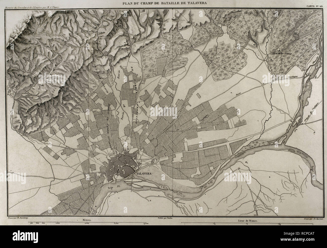 Napoleonic map. Battlefield of Talavera (Talavera de la Reina, province of Toledo, Castile-La Mancha, Spain). The Peninsular War. The Battle of Talavera, 27th-28th July 1809. It tooks place outside the town between the French army against allied forces (United Kingdom and Spain). Atlas de l'Histoire du Consulat et de l'Empire. History of the Consulate and the Empire of France under Napoleon by Marie Joseph Louis Adolphe Thiers (1797-1877). Drawings by Dufour, engravings by Dyonnet. Edited in Paris, 1864. Stock Photohttps://www.alamy.com/image-license-details/?v=1https://www.alamy.com/napoleonic-map-battlefield-of-talavera-talavera-de-la-reina-province-of-toledo-castile-la-mancha-spain-the-peninsular-war-the-battle-of-talavera-27th-28th-july-1809-it-tooks-place-outside-the-town-between-the-french-army-against-allied-forces-united-kingdom-and-spain-atlas-de-lhistoire-du-consulat-et-de-lempire-history-of-the-consulate-and-the-empire-of-france-under-napoleon-by-marie-joseph-louis-adolphe-thiers-1797-1877-drawings-by-dufour-engravings-by-dyonnet-edited-in-paris-1864-image231603312.html
RMRCPCAT–Napoleonic map. Battlefield of Talavera (Talavera de la Reina, province of Toledo, Castile-La Mancha, Spain). The Peninsular War. The Battle of Talavera, 27th-28th July 1809. It tooks place outside the town between the French army against allied forces (United Kingdom and Spain). Atlas de l'Histoire du Consulat et de l'Empire. History of the Consulate and the Empire of France under Napoleon by Marie Joseph Louis Adolphe Thiers (1797-1877). Drawings by Dufour, engravings by Dyonnet. Edited in Paris, 1864.
 The Young Buglers. A tale of the Peninsular War ... With ... illustrations by J. Proctor, etc Image taken from page 300 of 'The Young Buglers A Stock Photohttps://www.alamy.com/image-license-details/?v=1https://www.alamy.com/stock-photo-the-young-buglers-a-tale-of-the-peninsular-war-with-illustrations-85967928.html
RMEYT4Y4–The Young Buglers. A tale of the Peninsular War ... With ... illustrations by J. Proctor, etc Image taken from page 300 of 'The Young Buglers A
 1873 Atlas map of Crimea / Crimean Peninsular in the 19th century, with Kherson, Nikolaiev and Odessa visible. Pre-Russian revolution (1917). Stock Photohttps://www.alamy.com/image-license-details/?v=1https://www.alamy.com/1873-atlas-map-of-crimea-crimean-peninsular-in-the-19th-century-with-kherson-nikolaiev-and-odessa-visible-pre-russian-revolution-1917-image509042175.html
RM2MG4TDK–1873 Atlas map of Crimea / Crimean Peninsular in the 19th century, with Kherson, Nikolaiev and Odessa visible. Pre-Russian revolution (1917).
 Agustin Arguelles Stock Photohttps://www.alamy.com/image-license-details/?v=1https://www.alamy.com/stock-photo-agustin-arguelles-142509804.html
RMJ7RTKT–Agustin Arguelles
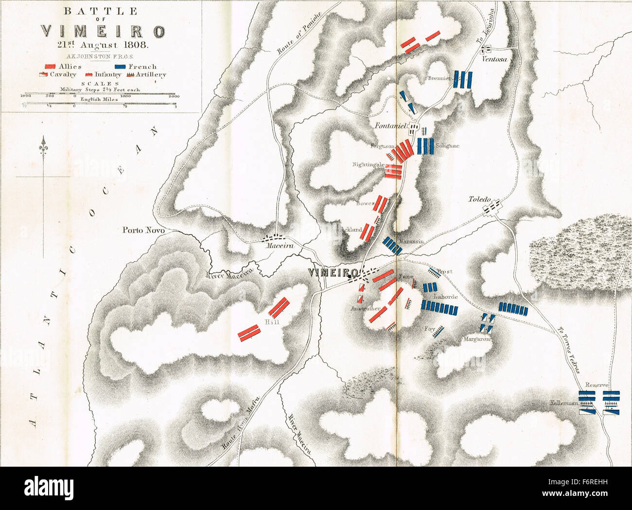 Map of the Battle of Vimeiro in 1808 Stock Photohttps://www.alamy.com/image-license-details/?v=1https://www.alamy.com/stock-photo-map-of-the-battle-of-vimeiro-in-1808-90256141.html
RMF6REHH–Map of the Battle of Vimeiro in 1808
 Civil War Maps 0533 Johnson's map of the vicinity of Richmond and Peninsular Campaign in Virginia showing also the interesting localities along the James Chickahominy and York rivers Rebuild and Repair Stock Photohttps://www.alamy.com/image-license-details/?v=1https://www.alamy.com/civil-war-maps-0533-johnsons-map-of-the-vicinity-of-richmond-and-peninsular-campaign-in-virginia-showing-also-the-interesting-localities-along-the-james-chickahominy-and-york-rivers-rebuild-and-repair-image261783845.html
RMW5W7Y1–Civil War Maps 0533 Johnson's map of the vicinity of Richmond and Peninsular Campaign in Virginia showing also the interesting localities along the James Chickahominy and York rivers Rebuild and Repair
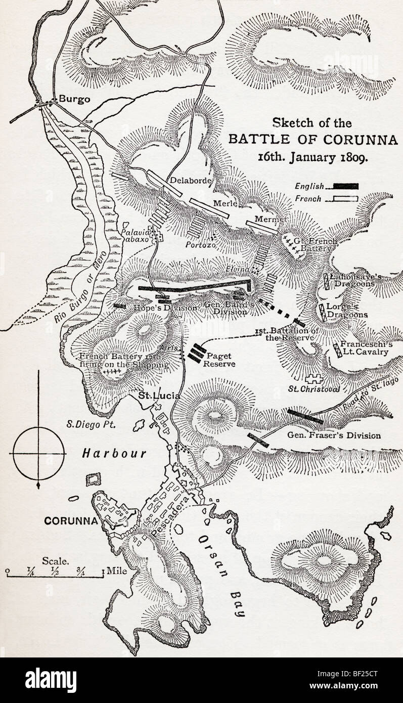 Map showing the site of the Battle of Corunna, Galicia, Spain, 16 January 1809. Stock Photohttps://www.alamy.com/image-license-details/?v=1https://www.alamy.com/stock-photo-map-showing-the-site-of-the-battle-of-corunna-galicia-spain-16-january-26478392.html
RMBF25CT–Map showing the site of the Battle of Corunna, Galicia, Spain, 16 January 1809.
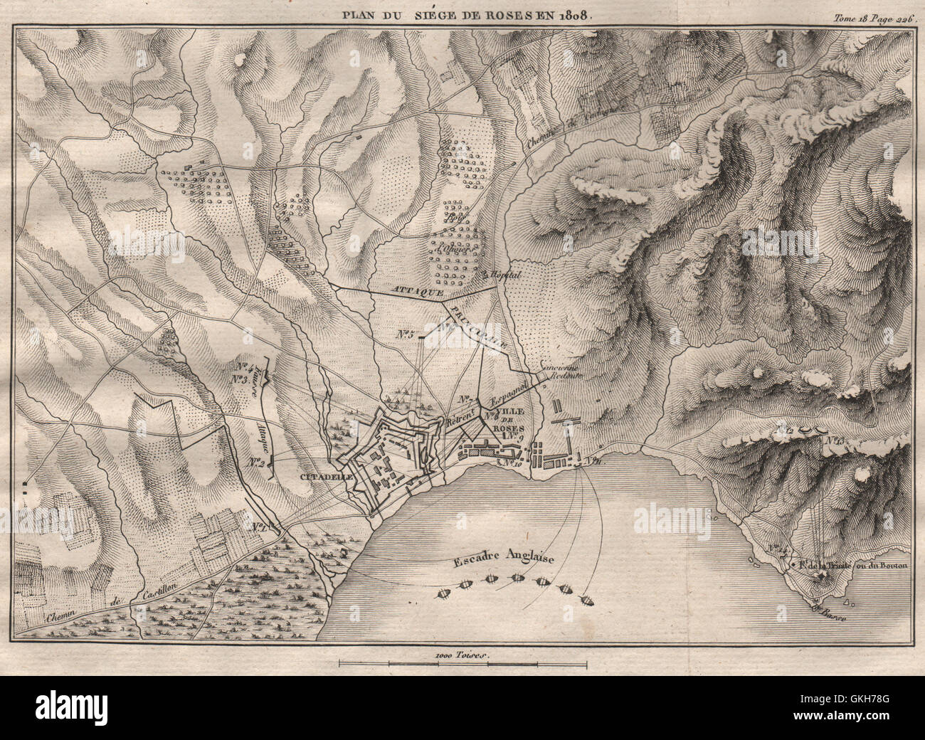 Siege of Roses (Rosas) 1808. Girona. Peninsular War. Spain, 1820 antique map Stock Photohttps://www.alamy.com/image-license-details/?v=1https://www.alamy.com/stock-photo-siege-of-roses-rosas-1808-girona-peninsular-war-spain-1820-antique-115319584.html
RFGKH78G–Siege of Roses (Rosas) 1808. Girona. Peninsular War. Spain, 1820 antique map
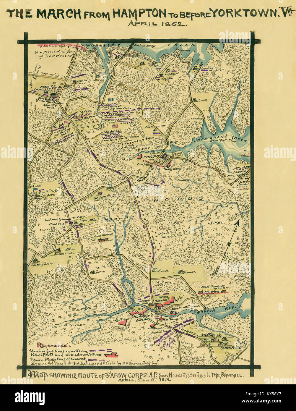 Map showing route of 3rd Army Corps. A.P. from Howard's Bridge to the sawmill Stock Photohttps://www.alamy.com/image-license-details/?v=1https://www.alamy.com/stock-photo-map-showing-route-of-3rd-army-corps-ap-from-howards-bridge-to-the-170991163.html
RMKX58Y7–Map showing route of 3rd Army Corps. A.P. from Howard's Bridge to the sawmill
 Battle of Orthez 27 February 1814. Peninsular War. Pyrénées Atlantiques 1850 map Stock Photohttps://www.alamy.com/image-license-details/?v=1https://www.alamy.com/battle-of-orthez-27-february-1814-peninsular-war-pyrnes-atlantiques-1850-map-image242587392.html
RFT2JPKC–Battle of Orthez 27 February 1814. Peninsular War. Pyrénées Atlantiques 1850 map
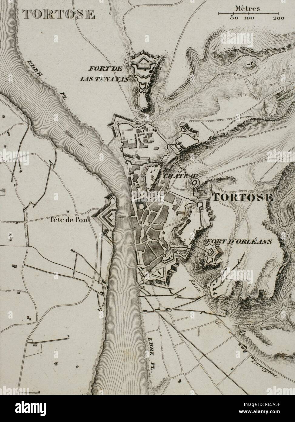 Napoleonic map. City of Tortosa (Catalonia, Spain). French troops sieged the town in December 1810. Peninsular War, part of the Napoleonic Wars. Atlas de l'Histoire du Consulat et de l'Empire. History of the Consulate and the Empire of France under Napoleon by Marie Joseph Louis Adolphe Thiers (1797-1877). Drawings by Dufour, engravings by Dyonnet. Edited in Paris, 1864. Stock Photohttps://www.alamy.com/image-license-details/?v=1https://www.alamy.com/napoleonic-map-city-of-tortosa-catalonia-spain-french-troops-sieged-the-town-in-december-1810-peninsular-war-part-of-the-napoleonic-wars-atlas-de-lhistoire-du-consulat-et-de-lempire-history-of-the-consulate-and-the-empire-of-france-under-napoleon-by-marie-joseph-louis-adolphe-thiers-1797-1877-drawings-by-dufour-engravings-by-dyonnet-edited-in-paris-1864-image232457723.html
RMRE5A5F–Napoleonic map. City of Tortosa (Catalonia, Spain). French troops sieged the town in December 1810. Peninsular War, part of the Napoleonic Wars. Atlas de l'Histoire du Consulat et de l'Empire. History of the Consulate and the Empire of France under Napoleon by Marie Joseph Louis Adolphe Thiers (1797-1877). Drawings by Dufour, engravings by Dyonnet. Edited in Paris, 1864.
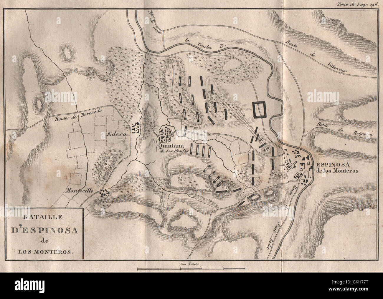 Battle of Espinosa de los Monteros 1808. Peninsular War. Spain, 1820 old map Stock Photohttps://www.alamy.com/image-license-details/?v=1https://www.alamy.com/stock-photo-battle-of-espinosa-de-los-monteros-1808-peninsular-war-spain-1820-115319564.html
RFGKH77T–Battle of Espinosa de los Monteros 1808. Peninsular War. Spain, 1820 old map
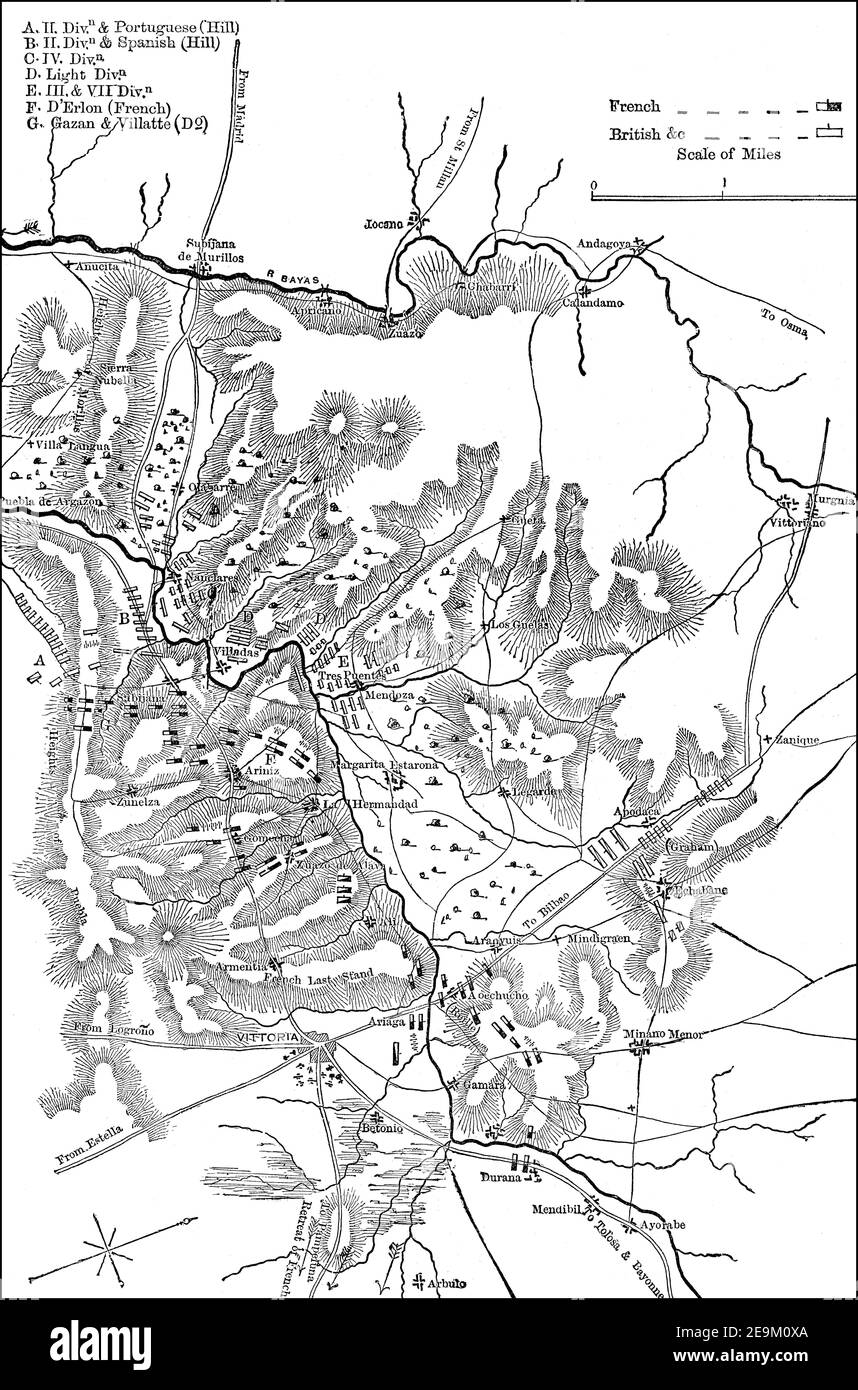 Battle of Vitoria, 21 June 1813, Peninsular War, From British Battles on Land and Sea by James Grant Stock Photohttps://www.alamy.com/image-license-details/?v=1https://www.alamy.com/battle-of-vitoria-21-june-1813-peninsular-war-from-british-battles-on-land-and-sea-by-james-grant-image401810146.html
RM2E9M0XA–Battle of Vitoria, 21 June 1813, Peninsular War, From British Battles on Land and Sea by James Grant
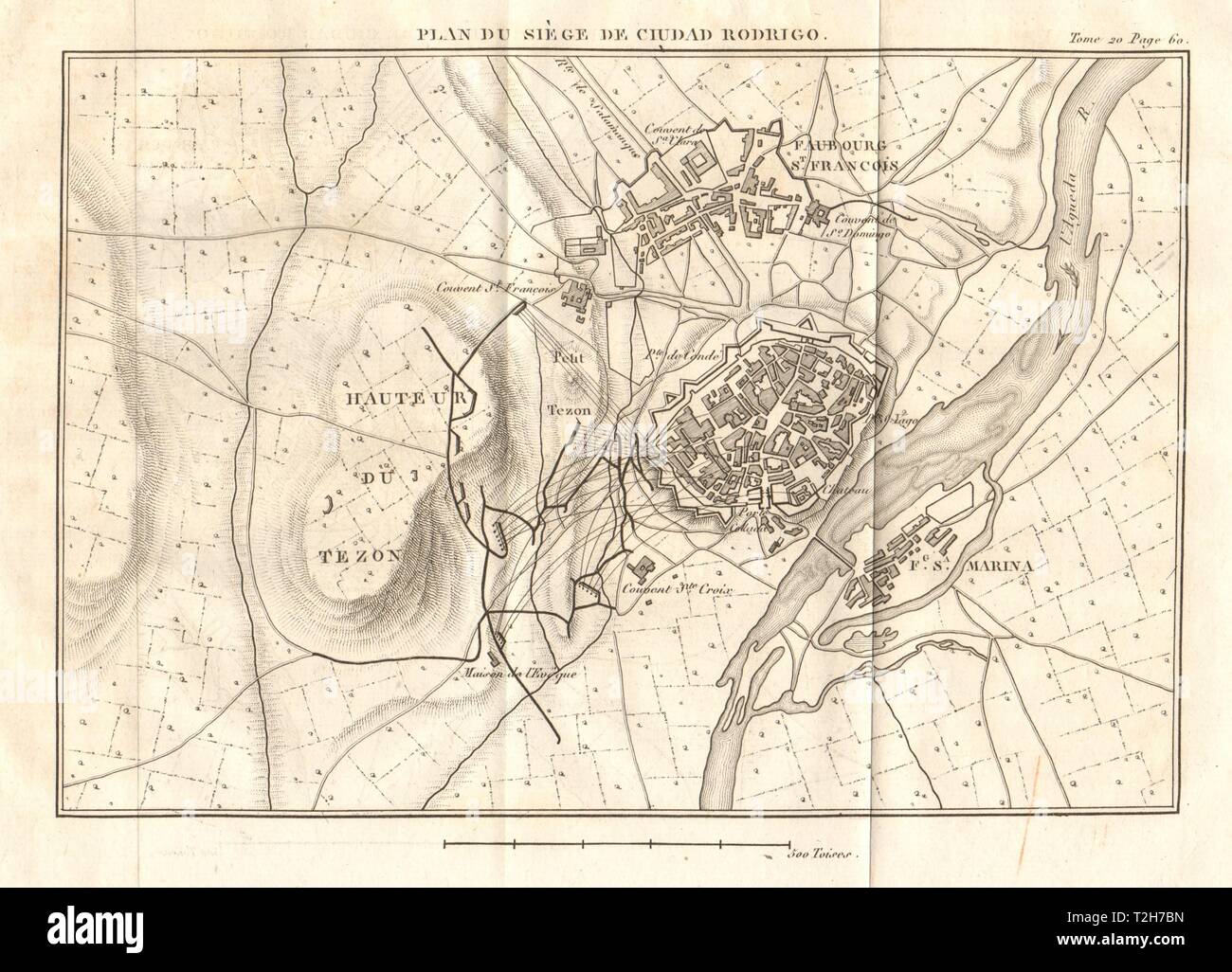 Siege of Ciudad-Rodrigo plan 1812. Salamanca, Spain. Peninsular War 1817 map Stock Photohttps://www.alamy.com/image-license-details/?v=1https://www.alamy.com/siege-of-ciudad-rodrigo-plan-1812-salamanca-spain-peninsular-war-1817-map-image242553465.html
RFT2H7BN–Siege of Ciudad-Rodrigo plan 1812. Salamanca, Spain. Peninsular War 1817 map
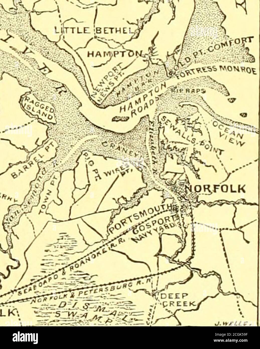 . Battles and leaders of the Civil War : being for the most part contributions by Union and Confederate officers, based upon 'The Century war series.' . jt la. MAP OF THE PENINSULAR CAMPAIGN. and he had withdi-awnbehind the Rapidan, theUrbana movement lostmuch of its promise,the enemy was now inposition to reach Rich-mond before we coulddo so. The alternativeremained of making Fort Monroe and its vicinity the base of operations.The plan first adopted was to commence the movement with the FustCorps as a unit, to land north of Grloucester and move thence on West Point;or, should circumstances re Stock Photohttps://www.alamy.com/image-license-details/?v=1https://www.alamy.com/battles-and-leaders-of-the-civil-war-being-for-the-most-part-contributions-by-union-and-confederate-officers-based-upon-the-century-war-series-jt-la-map-of-the-peninsular-campaign-and-he-had-withdi-awnbehind-the-rapidan-theurbana-movement-lostmuch-of-its-promisethe-enemy-was-now-inposition-to-reach-rich-mond-before-we-coulddo-so-the-alternativeremained-of-making-fort-monroe-and-its-vicinity-the-base-of-operationsthe-plan-first-adopted-was-to-commence-the-movement-with-the-fustcorps-as-a-unit-to-land-north-of-grloucester-and-move-thence-on-west-pointor-should-circumstances-re-image371673499.html
RM2CGK59F–. Battles and leaders of the Civil War : being for the most part contributions by Union and Confederate officers, based upon 'The Century war series.' . jt la. MAP OF THE PENINSULAR CAMPAIGN. and he had withdi-awnbehind the Rapidan, theUrbana movement lostmuch of its promise,the enemy was now inposition to reach Rich-mond before we coulddo so. The alternativeremained of making Fort Monroe and its vicinity the base of operations.The plan first adopted was to commence the movement with the FustCorps as a unit, to land north of Grloucester and move thence on West Point;or, should circumstances re
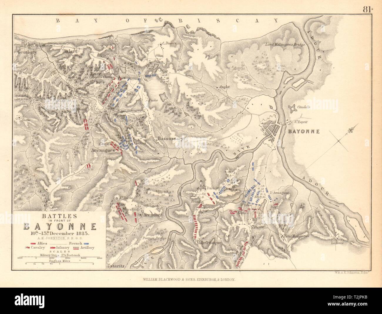 Battle of the Nive 10-13 December 1813 Bayonne Biarritz. Peninsular War 1850 map Stock Photohttps://www.alamy.com/image-license-details/?v=1https://www.alamy.com/battle-of-the-nive-10-13-december-1813-bayonne-biarritz-peninsular-war-1850-map-image242587391.html
RFT2JPKB–Battle of the Nive 10-13 December 1813 Bayonne Biarritz. Peninsular War 1850 map
 . Satire on the Peninsular war. (British political cartoon); A satire on Joseph Bonaparte's elevation to the throne of Spain, 6 June, 1808, and his flight from Madrid, 29 July, 1808. Joseph rises from a desk in a notary's office to put one toe on a map of Spain. Above his head he holds the crown and sceptre of Spain.; Ink stamp: RA From the desk to the throne: A new quick step by Joseph Bonaparte The bass by Messrs. Nappy and Tally. 18 August 1808. Bodleian Libraries, From the desk to the throne- A new quick step by Joseph Bonaparte The bass by Messrs Nappy and Tally Stock Photohttps://www.alamy.com/image-license-details/?v=1https://www.alamy.com/satire-on-the-peninsular-war-british-political-cartoon-a-satire-on-joseph-bonapartes-elevation-to-the-throne-of-spain-6-june-1808-and-his-flight-from-madrid-29-july-1808-joseph-rises-from-a-desk-in-a-notarys-office-to-put-one-toe-on-a-map-of-spain-above-his-head-he-holds-the-crown-and-sceptre-of-spain-ink-stamp-ra-from-the-desk-to-the-throne-a-new-quick-step-by-joseph-bonaparte-the-bass-by-messrs-nappy-and-tally-18-august-1808-bodleian-libraries-from-the-desk-to-the-throne-a-new-quick-step-by-joseph-bonaparte-the-bass-by-messrs-nappy-and-tally-image184929530.html
RMMMT7E2–. Satire on the Peninsular war. (British political cartoon); A satire on Joseph Bonaparte's elevation to the throne of Spain, 6 June, 1808, and his flight from Madrid, 29 July, 1808. Joseph rises from a desk in a notary's office to put one toe on a map of Spain. Above his head he holds the crown and sceptre of Spain.; Ink stamp: RA From the desk to the throne: A new quick step by Joseph Bonaparte The bass by Messrs. Nappy and Tally. 18 August 1808. Bodleian Libraries, From the desk to the throne- A new quick step by Joseph Bonaparte The bass by Messrs Nappy and Tally
 Bacon's map of the vicinity of Richmond, and Peninsular Campaign in Virginia : showing also the interesting localities along the James, Chickahominy and York Rivers , Peninsular Campaign, 1862, Maps, Richmond Va., History, Civil War, 1861-1865, Maps Norman B. Leventhal Map Center Collection Stock Photohttps://www.alamy.com/image-license-details/?v=1https://www.alamy.com/bacons-map-of-the-vicinity-of-richmond-and-peninsular-campaign-in-virginia-showing-also-the-interesting-localities-along-the-james-chickahominy-and-york-rivers-peninsular-campaign-1862-maps-richmond-va-history-civil-war-1861-1865-maps-norman-b-leventhal-map-center-collection-image500198727.html
RM2M1P0G7–Bacon's map of the vicinity of Richmond, and Peninsular Campaign in Virginia : showing also the interesting localities along the James, Chickahominy and York Rivers , Peninsular Campaign, 1862, Maps, Richmond Va., History, Civil War, 1861-1865, Maps Norman B. Leventhal Map Center Collection
![A map of Johore and Singapore reproduced 1942, from a map compiled and drawn at the war office 1934. Johore & Singapore half tones, Series MDR 570. [Cairo] : [Survey Directorate, Middle East], 1942. Great Britain. Army. Royal Engineers. Field Survey Company, 512th. Scale 1:250 000. Source: Maps MOD MDR 570 North sheet. Stock Photo A map of Johore and Singapore reproduced 1942, from a map compiled and drawn at the war office 1934. Johore & Singapore half tones, Series MDR 570. [Cairo] : [Survey Directorate, Middle East], 1942. Great Britain. Army. Royal Engineers. Field Survey Company, 512th. Scale 1:250 000. Source: Maps MOD MDR 570 North sheet. Stock Photo](https://c8.alamy.com/comp/R58G5C/a-map-of-johore-and-singapore-reproduced-1942-from-a-map-compiled-and-drawn-at-the-war-office-1934-johore-singapore-half-tones-series-mdr-570-cairo-survey-directorate-middle-east-1942-great-britain-army-royal-engineers-field-survey-company-512th-scale-1250-000-source-maps-mod-mdr-570-north-sheet-R58G5C.jpg) A map of Johore and Singapore reproduced 1942, from a map compiled and drawn at the war office 1934. Johore & Singapore half tones, Series MDR 570. [Cairo] : [Survey Directorate, Middle East], 1942. Great Britain. Army. Royal Engineers. Field Survey Company, 512th. Scale 1:250 000. Source: Maps MOD MDR 570 North sheet. Stock Photohttps://www.alamy.com/image-license-details/?v=1https://www.alamy.com/a-map-of-johore-and-singapore-reproduced-1942-from-a-map-compiled-and-drawn-at-the-war-office-1934-johore-singapore-half-tones-series-mdr-570-cairo-survey-directorate-middle-east-1942-great-britain-army-royal-engineers-field-survey-company-512th-scale-1250-000-source-maps-mod-mdr-570-north-sheet-image226996376.html
A map of Johore and Singapore reproduced 1942, from a map compiled and drawn at the war office 1934. Johore & Singapore half tones, Series MDR 570. [Cairo] : [Survey Directorate, Middle East], 1942. Great Britain. Army. Royal Engineers. Field Survey Company, 512th. Scale 1:250 000. Source: Maps MOD MDR 570 North sheet. Stock Photohttps://www.alamy.com/image-license-details/?v=1https://www.alamy.com/a-map-of-johore-and-singapore-reproduced-1942-from-a-map-compiled-and-drawn-at-the-war-office-1934-johore-singapore-half-tones-series-mdr-570-cairo-survey-directorate-middle-east-1942-great-britain-army-royal-engineers-field-survey-company-512th-scale-1250-000-source-maps-mod-mdr-570-north-sheet-image226996376.htmlRMR58G5C–A map of Johore and Singapore reproduced 1942, from a map compiled and drawn at the war office 1934. Johore & Singapore half tones, Series MDR 570. [Cairo] : [Survey Directorate, Middle East], 1942. Great Britain. Army. Royal Engineers. Field Survey Company, 512th. Scale 1:250 000. Source: Maps MOD MDR 570 North sheet.
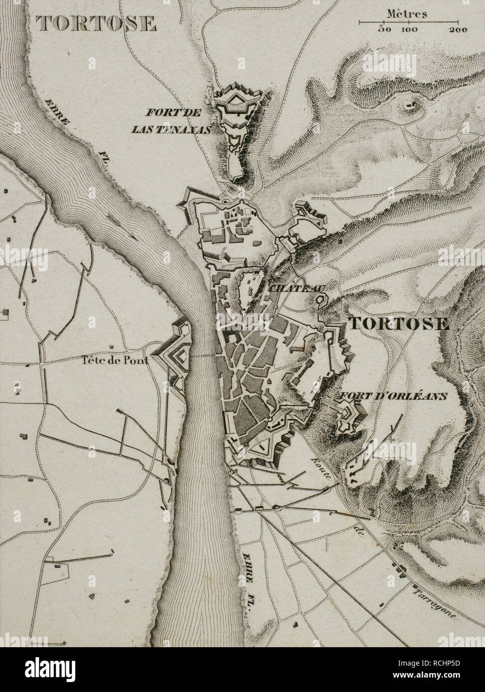 Napoleonic map. City of Tortosa (Catalonia, Spain). French troops sieged the town in December 1810. Peninsular War, part of the Napoleonic Wars. Atlas de l'Histoire du Consulat et de l'Empire. History of the Consulate and the Empire of France under Napoleon by Marie Joseph Louis Adolphe Thiers (1797-1877). Drawings by Dufour, engravings by Dyonnet. Edited in Paris, 1864. Stock Photohttps://www.alamy.com/image-license-details/?v=1https://www.alamy.com/napoleonic-map-city-of-tortosa-catalonia-spain-french-troops-sieged-the-town-in-december-1810-peninsular-war-part-of-the-napoleonic-wars-atlas-de-lhistoire-du-consulat-et-de-lempire-history-of-the-consulate-and-the-empire-of-france-under-napoleon-by-marie-joseph-louis-adolphe-thiers-1797-1877-drawings-by-dufour-engravings-by-dyonnet-edited-in-paris-1864-image231501241.html
RMRCHP5D–Napoleonic map. City of Tortosa (Catalonia, Spain). French troops sieged the town in December 1810. Peninsular War, part of the Napoleonic Wars. Atlas de l'Histoire du Consulat et de l'Empire. History of the Consulate and the Empire of France under Napoleon by Marie Joseph Louis Adolphe Thiers (1797-1877). Drawings by Dufour, engravings by Dyonnet. Edited in Paris, 1864.
 Replica of a camp during historical recreation of 'Los Sitios', the events that took place in Zaragoza, Spain, during the Peninsular War in the early Stock Photohttps://www.alamy.com/image-license-details/?v=1https://www.alamy.com/replica-of-a-camp-during-historical-recreation-of-los-sitios-the-events-that-took-place-in-zaragoza-spain-during-the-peninsular-war-in-the-early-image600331629.html
RM2WTKD39–Replica of a camp during historical recreation of 'Los Sitios', the events that took place in Zaragoza, Spain, during the Peninsular War in the early
 The Young Buglers. A tale of the Peninsular War ... With ... illustrations by J. Proctor, etc Image taken from page 350 of 'The Young Buglers A Stock Photohttps://www.alamy.com/image-license-details/?v=1https://www.alamy.com/stock-photo-the-young-buglers-a-tale-of-the-peninsular-war-with-illustrations-85969541.html
RMEYT70N–The Young Buglers. A tale of the Peninsular War ... With ... illustrations by J. Proctor, etc Image taken from page 350 of 'The Young Buglers A
 1873 Atlas map of Southern Ukraine & Crimea / Crimean Peninsular in the 19th century. Black Sea coastline, Kherson, Nikolaiev and Odessa visible. Stock Photohttps://www.alamy.com/image-license-details/?v=1https://www.alamy.com/1873-atlas-map-of-southern-ukraine-crimea-crimean-peninsular-in-the-19th-century-black-sea-coastline-kherson-nikolaiev-and-odessa-visible-image509041533.html
RM2MG4RJN–1873 Atlas map of Southern Ukraine & Crimea / Crimean Peninsular in the 19th century. Black Sea coastline, Kherson, Nikolaiev and Odessa visible.
 Civil War Maps 0532 Johnson's map of the vicinity of Richmond and Peninsular Campaign in Virginia showing also the interesting localities along the James Chickahominy and York rivers Rebuild and Repair Stock Photohttps://www.alamy.com/image-license-details/?v=1https://www.alamy.com/civil-war-maps-0532-johnsons-map-of-the-vicinity-of-richmond-and-peninsular-campaign-in-virginia-showing-also-the-interesting-localities-along-the-james-chickahominy-and-york-rivers-rebuild-and-repair-image261783837.html
RMW5W7XN–Civil War Maps 0532 Johnson's map of the vicinity of Richmond and Peninsular Campaign in Virginia showing also the interesting localities along the James Chickahominy and York rivers Rebuild and Repair
 Civil War Maps 0531 Johnson's map of the vicinity of Richmond and Peninsular Campaign in Virginia showing also the interesting localities along the James Chickahominy and York rivers Rebuild and Repair Stock Photohttps://www.alamy.com/image-license-details/?v=1https://www.alamy.com/civil-war-maps-0531-johnsons-map-of-the-vicinity-of-richmond-and-peninsular-campaign-in-virginia-showing-also-the-interesting-localities-along-the-james-chickahominy-and-york-rivers-rebuild-and-repair-image261783764.html
RMW5W7T4–Civil War Maps 0531 Johnson's map of the vicinity of Richmond and Peninsular Campaign in Virginia showing also the interesting localities along the James Chickahominy and York rivers Rebuild and Repair
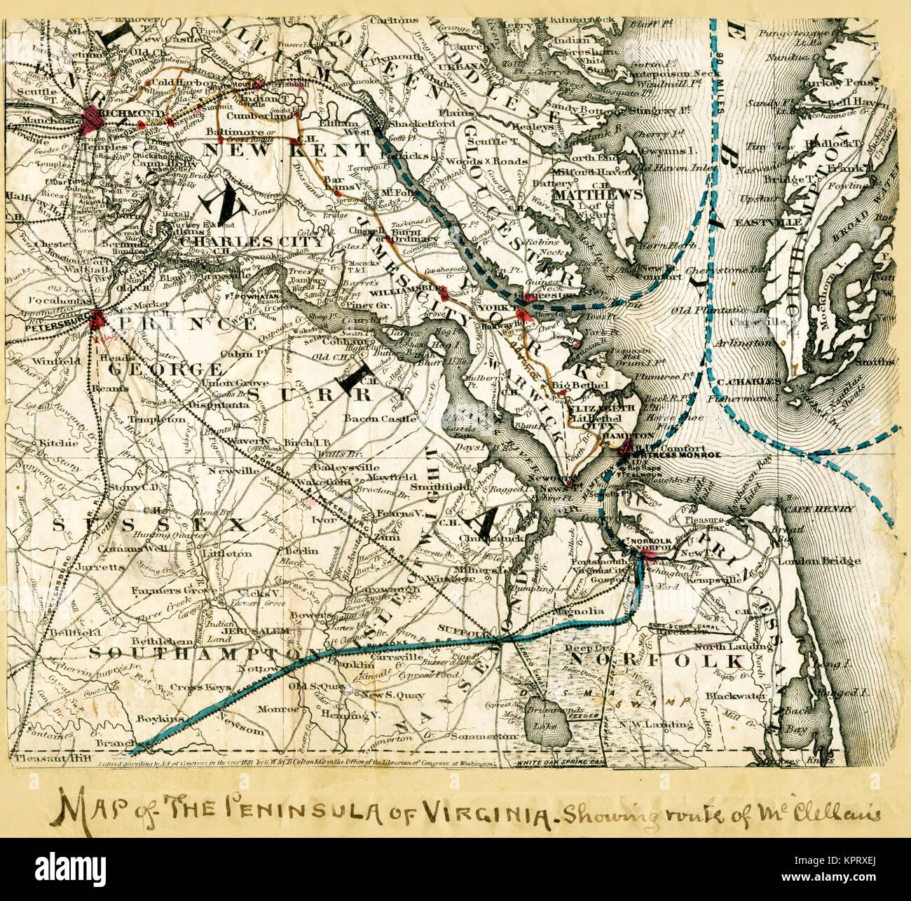 Map of the Peninsula of Virginia; McClellan's Army Stock Photohttps://www.alamy.com/image-license-details/?v=1https://www.alamy.com/stock-image-map-of-the-peninsula-of-virginia-mcclellans-army-168941434.html
RMKPRXEJ–Map of the Peninsula of Virginia; McClellan's Army
 Civil War Maps 0479 Hare's map of the vicinity of Richmond and Peninsular campaign in Virginia Showing also the interesting localities along the James Chickahominy and York Rivers Rebuild and Repair Stock Photohttps://www.alamy.com/image-license-details/?v=1https://www.alamy.com/civil-war-maps-0479-hares-map-of-the-vicinity-of-richmond-and-peninsular-campaign-in-virginia-showing-also-the-interesting-localities-along-the-james-chickahominy-and-york-rivers-rebuild-and-repair-image261719032.html
RMW5P988–Civil War Maps 0479 Hare's map of the vicinity of Richmond and Peninsular campaign in Virginia Showing also the interesting localities along the James Chickahominy and York Rivers Rebuild and Repair
 Napoleonic map. City of Lleida (Catalonia, Spain). During The Peninsular War (Napoleonic Wars) the city of Lerida was besieged on 13 May, 1810 by the French army. French victory. Atlas de l'Histoire du Consulat et de l'Empire. History of the Consulate and the Empire of France under Napoleon by Marie Joseph Louis Adolphe Thiers (1797-1877). Drawings by Dufour, engravings by Dyonnet. Edited in Paris, 1864. Stock Photohttps://www.alamy.com/image-license-details/?v=1https://www.alamy.com/napoleonic-map-city-of-lleida-catalonia-spain-during-the-peninsular-war-napoleonic-wars-the-city-of-lerida-was-besieged-on-13-may-1810-by-the-french-army-french-victory-atlas-de-lhistoire-du-consulat-et-de-lempire-history-of-the-consulate-and-the-empire-of-france-under-napoleon-by-marie-joseph-louis-adolphe-thiers-1797-1877-drawings-by-dufour-engravings-by-dyonnet-edited-in-paris-1864-image232457796.html
RMRE5A84–Napoleonic map. City of Lleida (Catalonia, Spain). During The Peninsular War (Napoleonic Wars) the city of Lerida was besieged on 13 May, 1810 by the French army. French victory. Atlas de l'Histoire du Consulat et de l'Empire. History of the Consulate and the Empire of France under Napoleon by Marie Joseph Louis Adolphe Thiers (1797-1877). Drawings by Dufour, engravings by Dyonnet. Edited in Paris, 1864.
 Civil War Maps 0532 Johnson's map of the vicinity of Richmond and Peninsular Campaign in Virginia showing also the interesting localities along the James Chickahominy and York rivers Inverted Rebuild and Repair Stock Photohttps://www.alamy.com/image-license-details/?v=1https://www.alamy.com/civil-war-maps-0532-johnsons-map-of-the-vicinity-of-richmond-and-peninsular-campaign-in-virginia-showing-also-the-interesting-localities-along-the-james-chickahominy-and-york-rivers-inverted-rebuild-and-repair-image261783674.html
RMW5W7MX–Civil War Maps 0532 Johnson's map of the vicinity of Richmond and Peninsular Campaign in Virginia showing also the interesting localities along the James Chickahominy and York rivers Inverted Rebuild and Repair
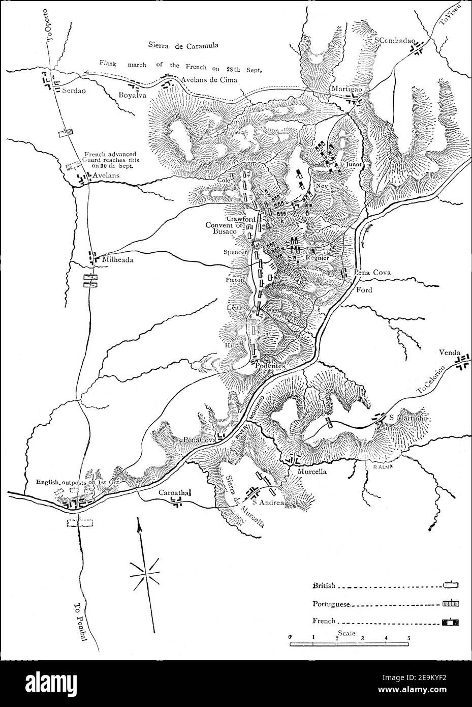 The Battle of Buçaco, Peninsular War, 27 September 1810, From British Battles on Land and Sea by James Grant Stock Photohttps://www.alamy.com/image-license-details/?v=1https://www.alamy.com/the-battle-of-buaco-peninsular-war-27-september-1810-from-british-battles-on-land-and-sea-by-james-grant-image401809046.html
RM2E9KYF2–The Battle of Buçaco, Peninsular War, 27 September 1810, From British Battles on Land and Sea by James Grant
 . The history of the Civil War in America; comprising a full and impartial account of the origin and progress of the rebellion, of the various naval and military engagements, of the heroic deeds performed by armies and individuals, and of touching scenes in the field, the camp, the hospital, and the cabin . MAP OI THE PENINSITLARCAMPAIGN. 0 .^^eaqym^ ^^ MAP OF THE PENINSULAR CAMPAIGN. THE EYACUATION OF MANASSAS. 2l President, annoyed by these constant calls for reenforcements, and impa-tient at the delay, consented that Franklins division of General McDowellscorps should be sent to General McC Stock Photohttps://www.alamy.com/image-license-details/?v=1https://www.alamy.com/the-history-of-the-civil-war-in-america-comprising-a-full-and-impartial-account-of-the-origin-and-progress-of-the-rebellion-of-the-various-naval-and-military-engagements-of-the-heroic-deeds-performed-by-armies-and-individuals-and-of-touching-scenes-in-the-field-the-camp-the-hospital-and-the-cabin-map-oi-the-peninsitlarcampaign-0-eaqym-map-of-the-peninsular-campaign-the-eyacuation-of-manassas-2l-president-annoyed-by-these-constant-calls-for-reenforcements-and-impa-tient-at-the-delay-consented-that-franklins-division-of-general-mcdowellscorps-should-be-sent-to-general-mcc-image371708750.html
RM2CGMP8E–. The history of the Civil War in America; comprising a full and impartial account of the origin and progress of the rebellion, of the various naval and military engagements, of the heroic deeds performed by armies and individuals, and of touching scenes in the field, the camp, the hospital, and the cabin . MAP OI THE PENINSITLARCAMPAIGN. 0 .^^eaqym^ ^^ MAP OF THE PENINSULAR CAMPAIGN. THE EYACUATION OF MANASSAS. 2l President, annoyed by these constant calls for reenforcements, and impa-tient at the delay, consented that Franklins division of General McDowellscorps should be sent to General McC
![Map of the east coast of Spain. Showing: Castilla; Murcia; Valenciana; Iviza; Mallorca. A new map of Spain and Portugal ... compiled by Jasper Nantiat. London : Published by W. Faden ... Charing Cross, Jan. 1st. 1810. 1 map on 4 sheets : hand col ; 110x154cm., on sheets 53x84cm.; Scale [ca. 1:860 000]. British miles, 80 [=146mm]. Source: Maps C.12.f.4. Sheet 4. Stock Photo Map of the east coast of Spain. Showing: Castilla; Murcia; Valenciana; Iviza; Mallorca. A new map of Spain and Portugal ... compiled by Jasper Nantiat. London : Published by W. Faden ... Charing Cross, Jan. 1st. 1810. 1 map on 4 sheets : hand col ; 110x154cm., on sheets 53x84cm.; Scale [ca. 1:860 000]. British miles, 80 [=146mm]. Source: Maps C.12.f.4. Sheet 4. Stock Photo](https://c8.alamy.com/comp/R5FGAB/map-of-the-east-coast-of-spain-showing-castilla-murcia-valenciana-iviza-mallorca-a-new-map-of-spain-and-portugal-compiled-by-jasper-nantiat-london-published-by-w-faden-charing-cross-jan-1st-1810-1-map-on-4-sheets-hand-col-110x154cm-on-sheets-53x84cm-scale-ca-1860-000-british-miles-80-=146mm-source-maps-c12f4-sheet-4-R5FGAB.jpg) Map of the east coast of Spain. Showing: Castilla; Murcia; Valenciana; Iviza; Mallorca. A new map of Spain and Portugal ... compiled by Jasper Nantiat. London : Published by W. Faden ... Charing Cross, Jan. 1st. 1810. 1 map on 4 sheets : hand col ; 110x154cm., on sheets 53x84cm.; Scale [ca. 1:860 000]. British miles, 80 [=146mm]. Source: Maps C.12.f.4. Sheet 4. Stock Photohttps://www.alamy.com/image-license-details/?v=1https://www.alamy.com/map-of-the-east-coast-of-spain-showing-castilla-murcia-valenciana-iviza-mallorca-a-new-map-of-spain-and-portugal-compiled-by-jasper-nantiat-london-published-by-w-faden-charing-cross-jan-1st-1810-1-map-on-4-sheets-hand-col-110x154cm-on-sheets-53x84cm-scale-ca-1860-000-british-miles-80-=146mm-source-maps-c12f4-sheet-4-image227150179.html
Map of the east coast of Spain. Showing: Castilla; Murcia; Valenciana; Iviza; Mallorca. A new map of Spain and Portugal ... compiled by Jasper Nantiat. London : Published by W. Faden ... Charing Cross, Jan. 1st. 1810. 1 map on 4 sheets : hand col ; 110x154cm., on sheets 53x84cm.; Scale [ca. 1:860 000]. British miles, 80 [=146mm]. Source: Maps C.12.f.4. Sheet 4. Stock Photohttps://www.alamy.com/image-license-details/?v=1https://www.alamy.com/map-of-the-east-coast-of-spain-showing-castilla-murcia-valenciana-iviza-mallorca-a-new-map-of-spain-and-portugal-compiled-by-jasper-nantiat-london-published-by-w-faden-charing-cross-jan-1st-1810-1-map-on-4-sheets-hand-col-110x154cm-on-sheets-53x84cm-scale-ca-1860-000-british-miles-80-=146mm-source-maps-c12f4-sheet-4-image227150179.htmlRMR5FGAB–Map of the east coast of Spain. Showing: Castilla; Murcia; Valenciana; Iviza; Mallorca. A new map of Spain and Portugal ... compiled by Jasper Nantiat. London : Published by W. Faden ... Charing Cross, Jan. 1st. 1810. 1 map on 4 sheets : hand col ; 110x154cm., on sheets 53x84cm.; Scale [ca. 1:860 000]. British miles, 80 [=146mm]. Source: Maps C.12.f.4. Sheet 4.
 Napoleonic map. Ciudad Rodrigo (province of Salamanca, Castile and Leon, Spain). During the Peninsulan War the city was besieged twice, 1810 and 1812. Atlas de l'Histoire du Consulat et de l'Empire. History of the Consulate and the Empire of France under Napoleon by Marie Joseph Louis Adolphe Thiers (1797-1877). Drawings by Dufour, engravings by Dyonnet. Edited in Paris, 1864. Stock Photohttps://www.alamy.com/image-license-details/?v=1https://www.alamy.com/napoleonic-map-ciudad-rodrigo-province-of-salamanca-castile-and-leon-spain-during-the-peninsulan-war-the-city-was-besieged-twice-1810-and-1812-atlas-de-lhistoire-du-consulat-et-de-lempire-history-of-the-consulate-and-the-empire-of-france-under-napoleon-by-marie-joseph-louis-adolphe-thiers-1797-1877-drawings-by-dufour-engravings-by-dyonnet-edited-in-paris-1864-image231603290.html
RMRCPCA2–Napoleonic map. Ciudad Rodrigo (province of Salamanca, Castile and Leon, Spain). During the Peninsulan War the city was besieged twice, 1810 and 1812. Atlas de l'Histoire du Consulat et de l'Empire. History of the Consulate and the Empire of France under Napoleon by Marie Joseph Louis Adolphe Thiers (1797-1877). Drawings by Dufour, engravings by Dyonnet. Edited in Paris, 1864.
 Image taken from page 350 of 'The Young Buglers. A tale of the Peninsular War ... With ... illustrations by J. Proctor, etc' Image taken from page 350 of 'The Young Buglers A Stock Photohttps://www.alamy.com/image-license-details/?v=1https://www.alamy.com/stock-photo-image-taken-from-page-350-of-the-young-buglers-a-tale-of-the-peninsular-85969543.html
RMEYT70R–Image taken from page 350 of 'The Young Buglers. A tale of the Peninsular War ... With ... illustrations by J. Proctor, etc' Image taken from page 350 of 'The Young Buglers A
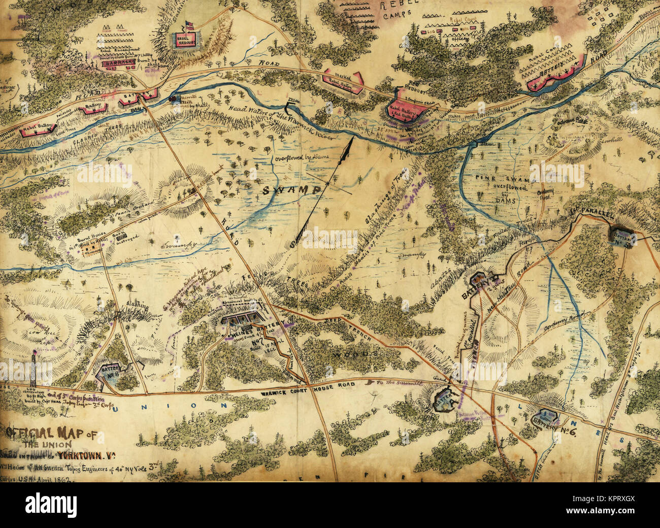 Official map of the Union works in front of Yorktown, Va. Stock Photohttps://www.alamy.com/image-license-details/?v=1https://www.alamy.com/stock-image-official-map-of-the-union-works-in-front-of-yorktown-va-168941498.html
RMKPRXGX–Official map of the Union works in front of Yorktown, Va.
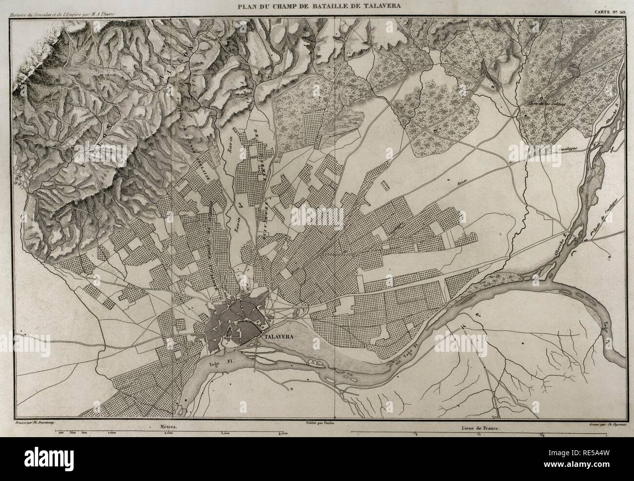 Napoleonic map. Battlefield of Talavera (Talavera de la Reina, province of Toledo, Castile-La Mancha, Spain). The Peninsular War. The Battle of Talavera, 27th-28th July 1809. It tooks place outside the town between the French army against allied forces (United Kingdom and Spain). Atlas de l'Histoire du Consulat et de l'Empire. History of the Consulate and the Empire of France under Napoleon by Marie Joseph Louis Adolphe Thiers (1797-1877). Drawings by Dufour, engravings by Dyonnet. Edited in Paris, 1864. Stock Photohttps://www.alamy.com/image-license-details/?v=1https://www.alamy.com/napoleonic-map-battlefield-of-talavera-talavera-de-la-reina-province-of-toledo-castile-la-mancha-spain-the-peninsular-war-the-battle-of-talavera-27th-28th-july-1809-it-tooks-place-outside-the-town-between-the-french-army-against-allied-forces-united-kingdom-and-spain-atlas-de-lhistoire-du-consulat-et-de-lempire-history-of-the-consulate-and-the-empire-of-france-under-napoleon-by-marie-joseph-louis-adolphe-thiers-1797-1877-drawings-by-dufour-engravings-by-dyonnet-edited-in-paris-1864-image232457705.html
RMRE5A4W–Napoleonic map. Battlefield of Talavera (Talavera de la Reina, province of Toledo, Castile-La Mancha, Spain). The Peninsular War. The Battle of Talavera, 27th-28th July 1809. It tooks place outside the town between the French army against allied forces (United Kingdom and Spain). Atlas de l'Histoire du Consulat et de l'Empire. History of the Consulate and the Empire of France under Napoleon by Marie Joseph Louis Adolphe Thiers (1797-1877). Drawings by Dufour, engravings by Dyonnet. Edited in Paris, 1864.
 Civil War Maps 0533 Johnson's map of the vicinity of Richmond and Peninsular Campaign in Virginia showing also the interesting localities along the James Chickahominy and York rivers Inverted Rebuild and Repair Stock Photohttps://www.alamy.com/image-license-details/?v=1https://www.alamy.com/civil-war-maps-0533-johnsons-map-of-the-vicinity-of-richmond-and-peninsular-campaign-in-virginia-showing-also-the-interesting-localities-along-the-james-chickahominy-and-york-rivers-inverted-rebuild-and-repair-image261783833.html
RMW5W7XH–Civil War Maps 0533 Johnson's map of the vicinity of Richmond and Peninsular Campaign in Virginia showing also the interesting localities along the James Chickahominy and York rivers Inverted Rebuild and Repair
 Battle of Redinha on March 12, 1811, Peninsular War, From British Battles on Land and Sea by James Grant Stock Photohttps://www.alamy.com/image-license-details/?v=1https://www.alamy.com/battle-of-redinha-on-march-12-1811-peninsular-war-from-british-battles-on-land-and-sea-by-james-grant-image401809200.html
RM2E9KYMG–Battle of Redinha on March 12, 1811, Peninsular War, From British Battles on Land and Sea by James Grant
 Civil War Maps 0531 Johnson's map of the vicinity of Richmond and Peninsular Campaign in Virginia showing also the interesting localities along the James Chickahominy and York rivers Inverted Rebuild and Repair Stock Photohttps://www.alamy.com/image-license-details/?v=1https://www.alamy.com/civil-war-maps-0531-johnsons-map-of-the-vicinity-of-richmond-and-peninsular-campaign-in-virginia-showing-also-the-interesting-localities-along-the-james-chickahominy-and-york-rivers-inverted-rebuild-and-repair-image261783782.html
RMW5W7TP–Civil War Maps 0531 Johnson's map of the vicinity of Richmond and Peninsular Campaign in Virginia showing also the interesting localities along the James Chickahominy and York rivers Inverted Rebuild and Repair
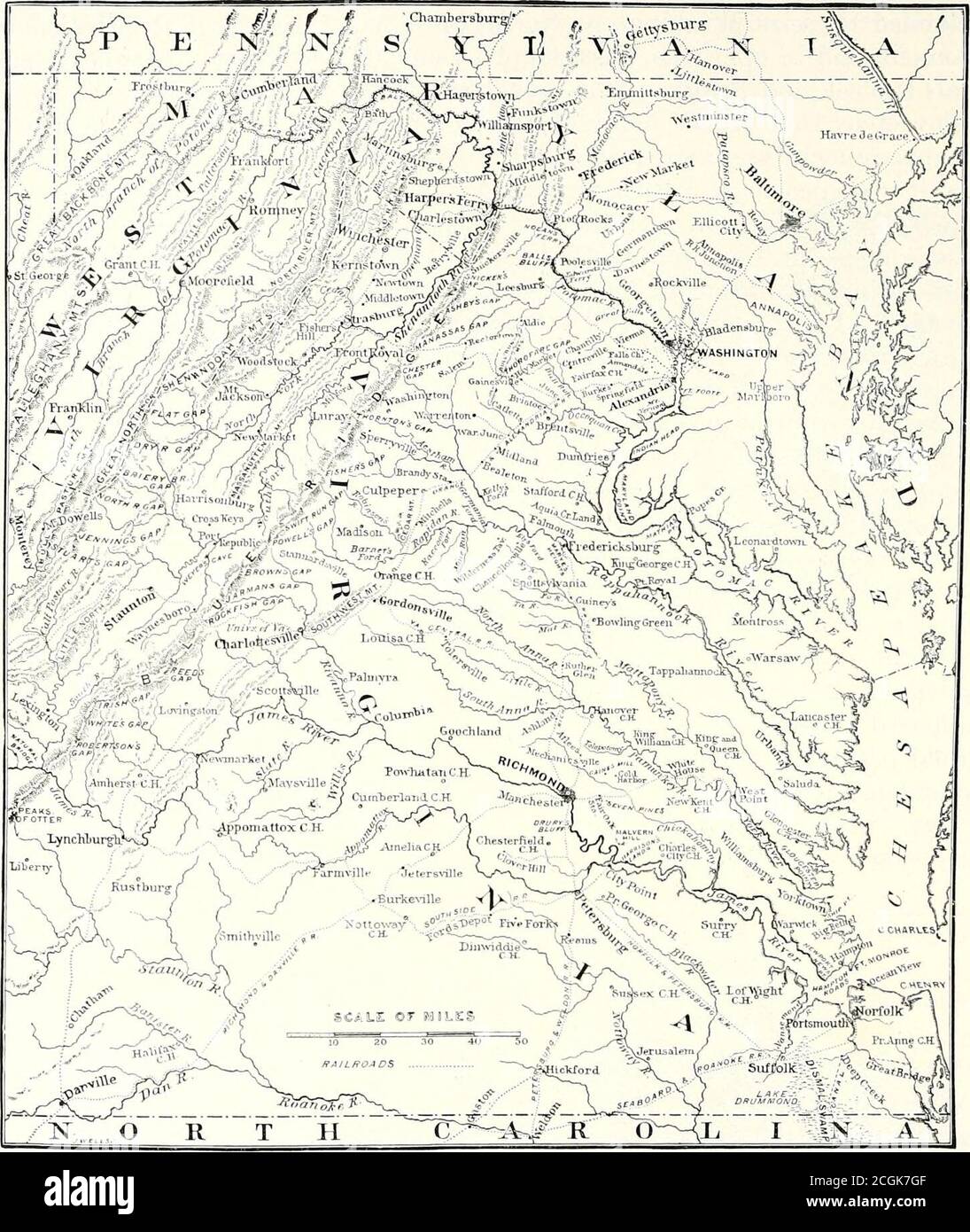 . Battles and leaders of the Civil War : being for the most part contributions by Union and Confederate officers . HEADQUAKTERS OF BRIGADIER-GENERAL JOHN SEDGWICK, ON THE LEESBURG TURNPIKE, NEAR WASHINGTON. FROM A SKETCH MADE IN JANUART, 1862. 164 THE PENINSULAR. CAMPAIGN.. MAP OF THE VIRGINIA CAMPAIGNS. him, even for the transaction of ordinary current business, and our personalrelations at once ceased. The impatience of the Executive immediatelybecame extreme, and I can attribute it only to the influence of the newSecretary, who did many things to break up the free and confidential inter-cou Stock Photohttps://www.alamy.com/image-license-details/?v=1https://www.alamy.com/battles-and-leaders-of-the-civil-war-being-for-the-most-part-contributions-by-union-and-confederate-officers-headquakters-of-brigadier-general-john-sedgwick-on-the-leesburg-turnpike-near-washington-from-a-sketch-made-in-januart-1862-164-the-peninsular-campaign-map-of-the-virginia-campaigns-him-even-for-the-transaction-of-ordinary-current-business-and-our-personalrelations-at-once-ceased-the-impatience-of-the-executive-immediatelybecame-extreme-and-i-can-attribute-it-only-to-the-influence-of-the-newsecretary-who-did-many-things-to-break-up-the-free-and-confidential-inter-cou-image371675263.html
RM2CGK7GF–. Battles and leaders of the Civil War : being for the most part contributions by Union and Confederate officers . HEADQUAKTERS OF BRIGADIER-GENERAL JOHN SEDGWICK, ON THE LEESBURG TURNPIKE, NEAR WASHINGTON. FROM A SKETCH MADE IN JANUART, 1862. 164 THE PENINSULAR. CAMPAIGN.. MAP OF THE VIRGINIA CAMPAIGNS. him, even for the transaction of ordinary current business, and our personalrelations at once ceased. The impatience of the Executive immediatelybecame extreme, and I can attribute it only to the influence of the newSecretary, who did many things to break up the free and confidential inter-cou
 Civil War Maps 0479 Hare's map of the vicinity of Richmond and Peninsular campaign in Virginia Showing also the interesting localities along the James Chickahominy and York Rivers Inverted Rebuild and Repair Stock Photohttps://www.alamy.com/image-license-details/?v=1https://www.alamy.com/civil-war-maps-0479-hares-map-of-the-vicinity-of-richmond-and-peninsular-campaign-in-virginia-showing-also-the-interesting-localities-along-the-james-chickahominy-and-york-rivers-inverted-rebuild-and-repair-image261719099.html
RMW5P9AK–Civil War Maps 0479 Hare's map of the vicinity of Richmond and Peninsular campaign in Virginia Showing also the interesting localities along the James Chickahominy and York Rivers Inverted Rebuild and Repair
![Map of France and Spain. Place names in bold: Aragon; Cataluna; Navarra; Soria; and, Cuenca. A new map of Spain and Portugal ... compiled by Jasper Nantiat. London : Published by W. Faden ... Charing Cross, Jan. 1st. 1810. 1 map on 4 sheets : hand col ; 110x154cm., on sheets 53x84cm.; Scale [ca. 1:860 000]. British miles, 80 [=146mm]. Source: Maps C.12.f.4. Sheet 2. Stock Photo Map of France and Spain. Place names in bold: Aragon; Cataluna; Navarra; Soria; and, Cuenca. A new map of Spain and Portugal ... compiled by Jasper Nantiat. London : Published by W. Faden ... Charing Cross, Jan. 1st. 1810. 1 map on 4 sheets : hand col ; 110x154cm., on sheets 53x84cm.; Scale [ca. 1:860 000]. British miles, 80 [=146mm]. Source: Maps C.12.f.4. Sheet 2. Stock Photo](https://c8.alamy.com/comp/R5CCBR/map-of-france-and-spain-place-names-in-bold-aragon-cataluna-navarra-soria-and-cuenca-a-new-map-of-spain-and-portugal-compiled-by-jasper-nantiat-london-published-by-w-faden-charing-cross-jan-1st-1810-1-map-on-4-sheets-hand-col-110x154cm-on-sheets-53x84cm-scale-ca-1860-000-british-miles-80-=146mm-source-maps-c12f4-sheet-2-R5CCBR.jpg) Map of France and Spain. Place names in bold: Aragon; Cataluna; Navarra; Soria; and, Cuenca. A new map of Spain and Portugal ... compiled by Jasper Nantiat. London : Published by W. Faden ... Charing Cross, Jan. 1st. 1810. 1 map on 4 sheets : hand col ; 110x154cm., on sheets 53x84cm.; Scale [ca. 1:860 000]. British miles, 80 [=146mm]. Source: Maps C.12.f.4. Sheet 2. Stock Photohttps://www.alamy.com/image-license-details/?v=1https://www.alamy.com/map-of-france-and-spain-place-names-in-bold-aragon-cataluna-navarra-soria-and-cuenca-a-new-map-of-spain-and-portugal-compiled-by-jasper-nantiat-london-published-by-w-faden-charing-cross-jan-1st-1810-1-map-on-4-sheets-hand-col-110x154cm-on-sheets-53x84cm-scale-ca-1860-000-british-miles-80-=146mm-source-maps-c12f4-sheet-2-image227081227.html
Map of France and Spain. Place names in bold: Aragon; Cataluna; Navarra; Soria; and, Cuenca. A new map of Spain and Portugal ... compiled by Jasper Nantiat. London : Published by W. Faden ... Charing Cross, Jan. 1st. 1810. 1 map on 4 sheets : hand col ; 110x154cm., on sheets 53x84cm.; Scale [ca. 1:860 000]. British miles, 80 [=146mm]. Source: Maps C.12.f.4. Sheet 2. Stock Photohttps://www.alamy.com/image-license-details/?v=1https://www.alamy.com/map-of-france-and-spain-place-names-in-bold-aragon-cataluna-navarra-soria-and-cuenca-a-new-map-of-spain-and-portugal-compiled-by-jasper-nantiat-london-published-by-w-faden-charing-cross-jan-1st-1810-1-map-on-4-sheets-hand-col-110x154cm-on-sheets-53x84cm-scale-ca-1860-000-british-miles-80-=146mm-source-maps-c12f4-sheet-2-image227081227.htmlRMR5CCBR–Map of France and Spain. Place names in bold: Aragon; Cataluna; Navarra; Soria; and, Cuenca. A new map of Spain and Portugal ... compiled by Jasper Nantiat. London : Published by W. Faden ... Charing Cross, Jan. 1st. 1810. 1 map on 4 sheets : hand col ; 110x154cm., on sheets 53x84cm.; Scale [ca. 1:860 000]. British miles, 80 [=146mm]. Source: Maps C.12.f.4. Sheet 2.
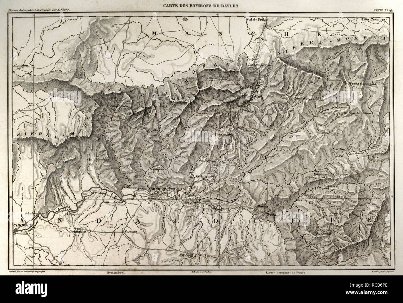 Napolenic map. Surrounding of the town of Bailen (province of Jaen, Andalusia, Spain). During the War of Spanish Independence it took place a battle in Bailen, the first defeat of the French army, 19 th July, 1808. Atlas de l'Histoire du Consulat et de l'Empire. History of the Consulate and the Empire of France under Napoleon by Marie Joseph Louis Adolphe Thiers (1797-1877). Drawings by Dufour, engravings by Dyonnet. Edited in Paris, 1864. Stock Photohttps://www.alamy.com/image-license-details/?v=1https://www.alamy.com/napolenic-map-surrounding-of-the-town-of-bailen-province-of-jaen-andalusia-spain-during-the-war-of-spanish-independence-it-took-place-a-battle-in-bailen-the-first-defeat-of-the-french-army-19-th-july-1808-atlas-de-lhistoire-du-consulat-et-de-lempire-history-of-the-consulate-and-the-empire-of-france-under-napoleon-by-marie-joseph-louis-adolphe-thiers-1797-1877-drawings-by-dufour-engravings-by-dyonnet-edited-in-paris-1864-image231357462.html
RMRCB6PE–Napolenic map. Surrounding of the town of Bailen (province of Jaen, Andalusia, Spain). During the War of Spanish Independence it took place a battle in Bailen, the first defeat of the French army, 19 th July, 1808. Atlas de l'Histoire du Consulat et de l'Empire. History of the Consulate and the Empire of France under Napoleon by Marie Joseph Louis Adolphe Thiers (1797-1877). Drawings by Dufour, engravings by Dyonnet. Edited in Paris, 1864.
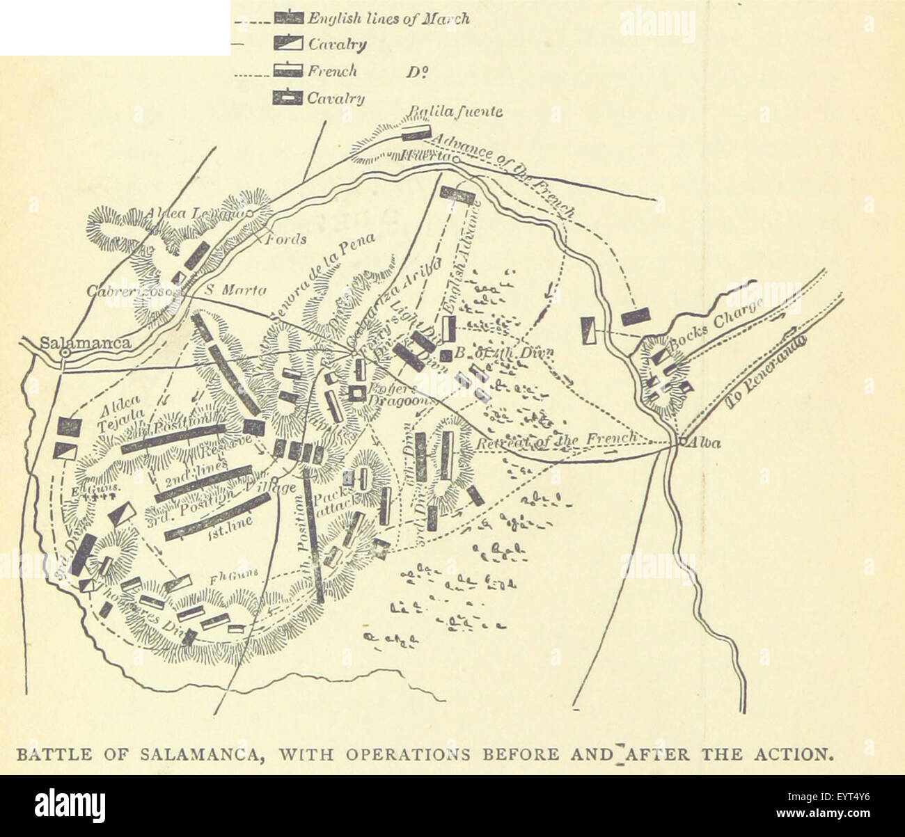 Image taken from page 300 of 'The Young Buglers. A tale of the Peninsular War ... With ... illustrations by J. Proctor, etc' Image taken from page 300 of 'The Young Buglers A Stock Photohttps://www.alamy.com/image-license-details/?v=1https://www.alamy.com/stock-photo-image-taken-from-page-300-of-the-young-buglers-a-tale-of-the-peninsular-85967930.html
RMEYT4Y6–Image taken from page 300 of 'The Young Buglers. A tale of the Peninsular War ... With ... illustrations by J. Proctor, etc' Image taken from page 300 of 'The Young Buglers A
 Chickahominy and James rivers and from Richmond to Harrison's Landing, Va. Stock Photohttps://www.alamy.com/image-license-details/?v=1https://www.alamy.com/stock-photo-chickahominy-and-james-rivers-and-from-richmond-to-harrisons-landing-170991177.html
RMKX58YN–Chickahominy and James rivers and from Richmond to Harrison's Landing, Va.
 Union Army Encampment is Hampton Stock Photohttps://www.alamy.com/image-license-details/?v=1https://www.alamy.com/stock-photo-union-army-encampment-is-hampton-171094620.html
RMKXA0X4–Union Army Encampment is Hampton
 Napoleonic map. Siege of Tarragona (Catalonia, Spain). Tarragona was besieged from 5 May to 29 June 1811. Troops belonging to the French Army of Aragon, commanded by General Suchet, fought against a Spanish garrison led by Lieutenant General Juan Senen de Contreras. A British naval squadron commanded by Admiral Edward Codrington harassed the French besiegers with cannon fire. The city was assaulted and occupied. The Peninsular War. Atlas de l'Histoire du Consulat et de l'Empire. History of the Consulate and the Empire of France under Napoleon by Marie Joseph Louis Adolphe Thiers (1797-1877). D Stock Photohttps://www.alamy.com/image-license-details/?v=1https://www.alamy.com/napoleonic-map-siege-of-tarragona-catalonia-spain-tarragona-was-besieged-from-5-may-to-29-june-1811-troops-belonging-to-the-french-army-of-aragon-commanded-by-general-suchet-fought-against-a-spanish-garrison-led-by-lieutenant-general-juan-senen-de-contreras-a-british-naval-squadron-commanded-by-admiral-edward-codrington-harassed-the-french-besiegers-with-cannon-fire-the-city-was-assaulted-and-occupied-the-peninsular-war-atlas-de-lhistoire-du-consulat-et-de-lempire-history-of-the-consulate-and-the-empire-of-france-under-napoleon-by-marie-joseph-louis-adolphe-thiers-1797-1877-d-image232457794.html
RMRE5A82–Napoleonic map. Siege of Tarragona (Catalonia, Spain). Tarragona was besieged from 5 May to 29 June 1811. Troops belonging to the French Army of Aragon, commanded by General Suchet, fought against a Spanish garrison led by Lieutenant General Juan Senen de Contreras. A British naval squadron commanded by Admiral Edward Codrington harassed the French besiegers with cannon fire. The city was assaulted and occupied. The Peninsular War. Atlas de l'Histoire du Consulat et de l'Empire. History of the Consulate and the Empire of France under Napoleon by Marie Joseph Louis Adolphe Thiers (1797-1877). D
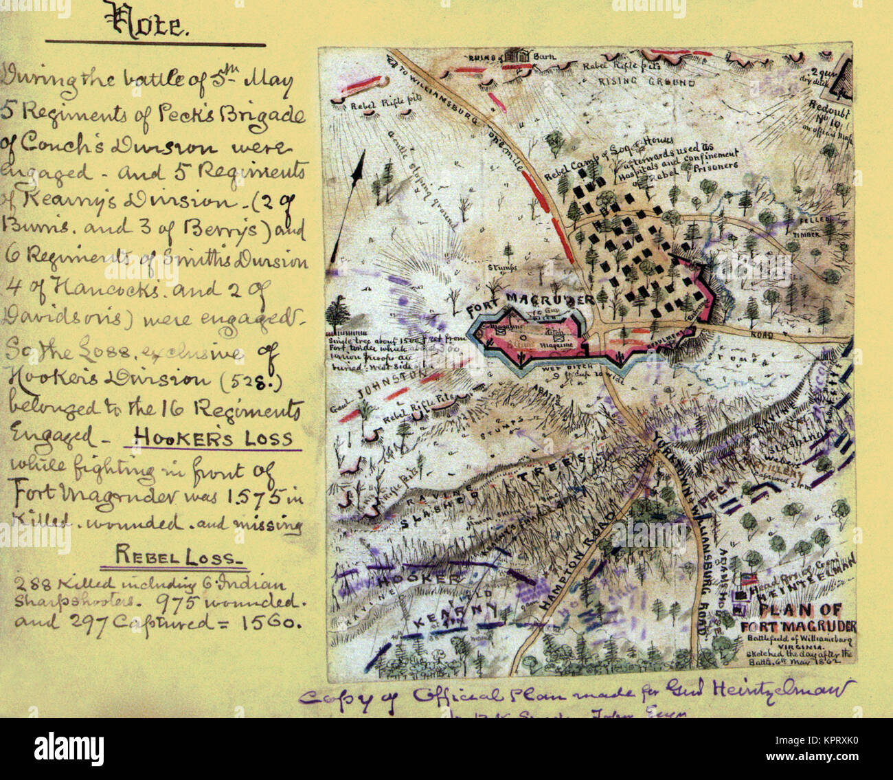 Plan of Fort Magruder, Battlefield of Williamsburg, Virginia Stock Photohttps://www.alamy.com/image-license-details/?v=1https://www.alamy.com/stock-image-plan-of-fort-magruder-battlefield-of-williamsburg-virginia-168941556.html
RMKPRXK0–Plan of Fort Magruder, Battlefield of Williamsburg, Virginia
 Battle of Albuera, 16 May 1811, Peninsular War, Spain, Peninsular War, From British Battles on Land and Sea by James Grant Stock Photohttps://www.alamy.com/image-license-details/?v=1https://www.alamy.com/battle-of-albuera-16-may-1811-peninsular-war-spain-peninsular-war-from-british-battles-on-land-and-sea-by-james-grant-image401809085.html
RM2E9KYGD–Battle of Albuera, 16 May 1811, Peninsular War, Spain, Peninsular War, From British Battles on Land and Sea by James Grant
![. Battles and leaders of the Civil War : being for the most part contributions by Union and Confederate officers, based upon 'The Century war series.' . FORT DARLrNG. [SEE MAP, P. 272.] FROM A PHOTOGRAPH. THE NAPY IN THE PENINSULAR CAMPAIGN.. During April the squadron was gi-adually increased by the addition of newvessels, including the new iron-clad Galena, and several fast steamers, theArago, VanderhiU, Illinois, and Ericsson, as rams. When it was apparent thatthe Confederates would shortly be compelled to abandon Norfolk, a squadron,consisting of the Galena, the gun-boat Aroostook, and the Stock Photo . Battles and leaders of the Civil War : being for the most part contributions by Union and Confederate officers, based upon 'The Century war series.' . FORT DARLrNG. [SEE MAP, P. 272.] FROM A PHOTOGRAPH. THE NAPY IN THE PENINSULAR CAMPAIGN.. During April the squadron was gi-adually increased by the addition of newvessels, including the new iron-clad Galena, and several fast steamers, theArago, VanderhiU, Illinois, and Ericsson, as rams. When it was apparent thatthe Confederates would shortly be compelled to abandon Norfolk, a squadron,consisting of the Galena, the gun-boat Aroostook, and the Stock Photo](https://c8.alamy.com/comp/2CGJMNH/battles-and-leaders-of-the-civil-war-being-for-the-most-part-contributions-by-union-and-confederate-officers-based-upon-the-century-war-series-fort-darlrng-see-map-p-272-from-a-photograph-the-napy-in-the-peninsular-campaign-during-april-the-squadron-was-gi-adually-increased-by-the-addition-of-newvessels-including-the-new-iron-clad-galena-and-several-fast-steamers-thearago-vanderhiu-illinois-and-ericsson-as-rams-when-it-was-apparent-thatthe-confederates-would-shortly-be-compelled-to-abandon-norfolk-a-squadronconsisting-of-the-galena-the-gun-boat-aroostook-and-the-2CGJMNH.jpg) . Battles and leaders of the Civil War : being for the most part contributions by Union and Confederate officers, based upon 'The Century war series.' . FORT DARLrNG. [SEE MAP, P. 272.] FROM A PHOTOGRAPH. THE NAPY IN THE PENINSULAR CAMPAIGN.. During April the squadron was gi-adually increased by the addition of newvessels, including the new iron-clad Galena, and several fast steamers, theArago, VanderhiU, Illinois, and Ericsson, as rams. When it was apparent thatthe Confederates would shortly be compelled to abandon Norfolk, a squadron,consisting of the Galena, the gun-boat Aroostook, and the Stock Photohttps://www.alamy.com/image-license-details/?v=1https://www.alamy.com/battles-and-leaders-of-the-civil-war-being-for-the-most-part-contributions-by-union-and-confederate-officers-based-upon-the-century-war-series-fort-darlrng-see-map-p-272-from-a-photograph-the-napy-in-the-peninsular-campaign-during-april-the-squadron-was-gi-adually-increased-by-the-addition-of-newvessels-including-the-new-iron-clad-galena-and-several-fast-steamers-thearago-vanderhiu-illinois-and-ericsson-as-rams-when-it-was-apparent-thatthe-confederates-would-shortly-be-compelled-to-abandon-norfolk-a-squadronconsisting-of-the-galena-the-gun-boat-aroostook-and-the-image371663645.html
. Battles and leaders of the Civil War : being for the most part contributions by Union and Confederate officers, based upon 'The Century war series.' . FORT DARLrNG. [SEE MAP, P. 272.] FROM A PHOTOGRAPH. THE NAPY IN THE PENINSULAR CAMPAIGN.. During April the squadron was gi-adually increased by the addition of newvessels, including the new iron-clad Galena, and several fast steamers, theArago, VanderhiU, Illinois, and Ericsson, as rams. When it was apparent thatthe Confederates would shortly be compelled to abandon Norfolk, a squadron,consisting of the Galena, the gun-boat Aroostook, and the Stock Photohttps://www.alamy.com/image-license-details/?v=1https://www.alamy.com/battles-and-leaders-of-the-civil-war-being-for-the-most-part-contributions-by-union-and-confederate-officers-based-upon-the-century-war-series-fort-darlrng-see-map-p-272-from-a-photograph-the-napy-in-the-peninsular-campaign-during-april-the-squadron-was-gi-adually-increased-by-the-addition-of-newvessels-including-the-new-iron-clad-galena-and-several-fast-steamers-thearago-vanderhiu-illinois-and-ericsson-as-rams-when-it-was-apparent-thatthe-confederates-would-shortly-be-compelled-to-abandon-norfolk-a-squadronconsisting-of-the-galena-the-gun-boat-aroostook-and-the-image371663645.htmlRM2CGJMNH–. Battles and leaders of the Civil War : being for the most part contributions by Union and Confederate officers, based upon 'The Century war series.' . FORT DARLrNG. [SEE MAP, P. 272.] FROM A PHOTOGRAPH. THE NAPY IN THE PENINSULAR CAMPAIGN.. During April the squadron was gi-adually increased by the addition of newvessels, including the new iron-clad Galena, and several fast steamers, theArago, VanderhiU, Illinois, and Ericsson, as rams. When it was apparent thatthe Confederates would shortly be compelled to abandon Norfolk, a squadron,consisting of the Galena, the gun-boat Aroostook, and the
![A map of Portugal and Spain. In bold: Algarve; Alentejo; Estremadura; Extremadura; Toledo; Cordoba; Laman; Granada and, Sevilla. A new map of Spain and Portugal ... compiled by Jasper Nantiat. London : Published by W. Faden ... Charing Cross, Jan. 1st. 1810. 1 map on 4 sheets : hand col ; 110x154cm., on sheets 53x84cm.; Scale [ca. 1:860 000]. British miles, 80 [=146mm]. Source: Maps C.12.f.4. Sheet 3. Stock Photo A map of Portugal and Spain. In bold: Algarve; Alentejo; Estremadura; Extremadura; Toledo; Cordoba; Laman; Granada and, Sevilla. A new map of Spain and Portugal ... compiled by Jasper Nantiat. London : Published by W. Faden ... Charing Cross, Jan. 1st. 1810. 1 map on 4 sheets : hand col ; 110x154cm., on sheets 53x84cm.; Scale [ca. 1:860 000]. British miles, 80 [=146mm]. Source: Maps C.12.f.4. Sheet 3. Stock Photo](https://c8.alamy.com/comp/R5G9XE/a-map-of-portugal-and-spain-in-bold-algarve-alentejo-estremadura-extremadura-toledo-cordoba-laman-granada-and-sevilla-a-new-map-of-spain-and-portugal-compiled-by-jasper-nantiat-london-published-by-w-faden-charing-cross-jan-1st-1810-1-map-on-4-sheets-hand-col-110x154cm-on-sheets-53x84cm-scale-ca-1860-000-british-miles-80-=146mm-source-maps-c12f4-sheet-3-R5G9XE.jpg) A map of Portugal and Spain. In bold: Algarve; Alentejo; Estremadura; Extremadura; Toledo; Cordoba; Laman; Granada and, Sevilla. A new map of Spain and Portugal ... compiled by Jasper Nantiat. London : Published by W. Faden ... Charing Cross, Jan. 1st. 1810. 1 map on 4 sheets : hand col ; 110x154cm., on sheets 53x84cm.; Scale [ca. 1:860 000]. British miles, 80 [=146mm]. Source: Maps C.12.f.4. Sheet 3. Stock Photohttps://www.alamy.com/image-license-details/?v=1https://www.alamy.com/a-map-of-portugal-and-spain-in-bold-algarve-alentejo-estremadura-extremadura-toledo-cordoba-laman-granada-and-sevilla-a-new-map-of-spain-and-portugal-compiled-by-jasper-nantiat-london-published-by-w-faden-charing-cross-jan-1st-1810-1-map-on-4-sheets-hand-col-110x154cm-on-sheets-53x84cm-scale-ca-1860-000-british-miles-80-=146mm-source-maps-c12f4-sheet-3-image227167094.html
A map of Portugal and Spain. In bold: Algarve; Alentejo; Estremadura; Extremadura; Toledo; Cordoba; Laman; Granada and, Sevilla. A new map of Spain and Portugal ... compiled by Jasper Nantiat. London : Published by W. Faden ... Charing Cross, Jan. 1st. 1810. 1 map on 4 sheets : hand col ; 110x154cm., on sheets 53x84cm.; Scale [ca. 1:860 000]. British miles, 80 [=146mm]. Source: Maps C.12.f.4. Sheet 3. Stock Photohttps://www.alamy.com/image-license-details/?v=1https://www.alamy.com/a-map-of-portugal-and-spain-in-bold-algarve-alentejo-estremadura-extremadura-toledo-cordoba-laman-granada-and-sevilla-a-new-map-of-spain-and-portugal-compiled-by-jasper-nantiat-london-published-by-w-faden-charing-cross-jan-1st-1810-1-map-on-4-sheets-hand-col-110x154cm-on-sheets-53x84cm-scale-ca-1860-000-british-miles-80-=146mm-source-maps-c12f4-sheet-3-image227167094.htmlRMR5G9XE–A map of Portugal and Spain. In bold: Algarve; Alentejo; Estremadura; Extremadura; Toledo; Cordoba; Laman; Granada and, Sevilla. A new map of Spain and Portugal ... compiled by Jasper Nantiat. London : Published by W. Faden ... Charing Cross, Jan. 1st. 1810. 1 map on 4 sheets : hand col ; 110x154cm., on sheets 53x84cm.; Scale [ca. 1:860 000]. British miles, 80 [=146mm]. Source: Maps C.12.f.4. Sheet 3.
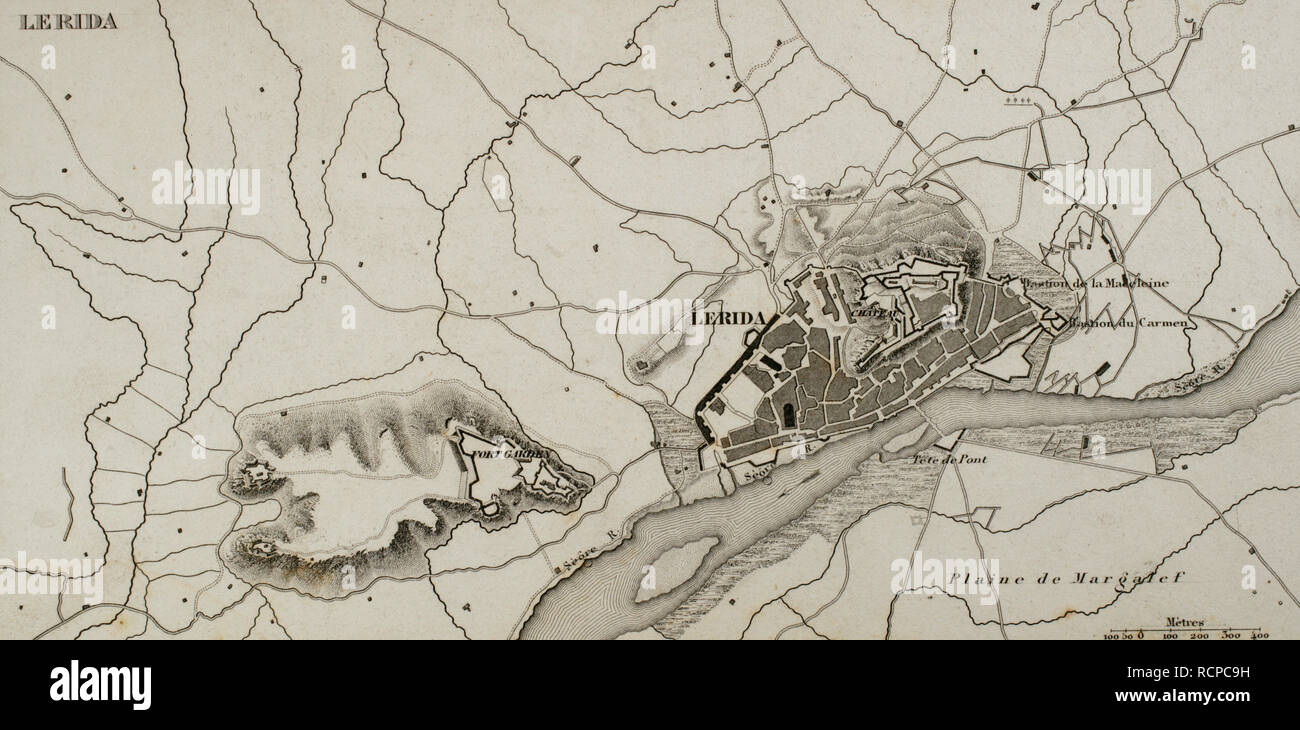 Napoleonic map. City of Lleida (Catalonia, Spain). During The Peninsular War (Napoleonic Wars) the city of Lerida was besieged on 13 May, 1810 by the French army. French victory. Atlas de l'Histoire du Consulat et de l'Empire. History of the Consulate and the Empire of France under Napoleon by Marie Joseph Louis Adolphe Thiers (1797-1877). Drawings by Dufour, engravings by Dyonnet. Edited in Paris, 1864. Stock Photohttps://www.alamy.com/image-license-details/?v=1https://www.alamy.com/napoleonic-map-city-of-lleida-catalonia-spain-during-the-peninsular-war-napoleonic-wars-the-city-of-lerida-was-besieged-on-13-may-1810-by-the-french-army-french-victory-atlas-de-lhistoire-du-consulat-et-de-lempire-history-of-the-consulate-and-the-empire-of-france-under-napoleon-by-marie-joseph-louis-adolphe-thiers-1797-1877-drawings-by-dufour-engravings-by-dyonnet-edited-in-paris-1864-image231603277.html
RMRCPC9H–Napoleonic map. City of Lleida (Catalonia, Spain). During The Peninsular War (Napoleonic Wars) the city of Lerida was besieged on 13 May, 1810 by the French army. French victory. Atlas de l'Histoire du Consulat et de l'Empire. History of the Consulate and the Empire of France under Napoleon by Marie Joseph Louis Adolphe Thiers (1797-1877). Drawings by Dufour, engravings by Dyonnet. Edited in Paris, 1864.
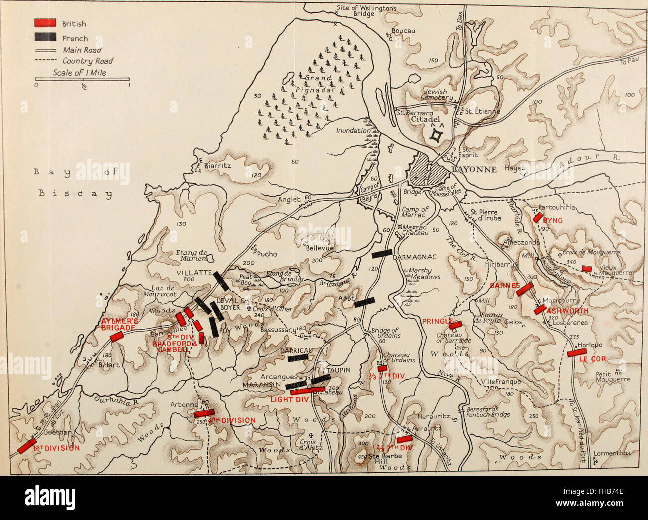 A history of the Peninsular War (1902) Stock Photohttps://www.alamy.com/image-license-details/?v=1https://www.alamy.com/stock-photo-a-history-of-the-peninsular-war-1902-96748078.html
RMFHB74E–A history of the Peninsular War (1902)
 Napoleonic map. Ciudad Rodrigo (province of Salamanca, Castile and Leon, Spain). During the Peninsulan War the city was besieged twice, 1810 and 1812. Atlas de l'Histoire du Consulat et de l'Empire. History of the Consulate and the Empire of France under Napoleon by Marie Joseph Louis Adolphe Thiers (1797-1877). Drawings by Dufour, engravings by Dyonnet. Edited in Paris, 1864. Stock Photohttps://www.alamy.com/image-license-details/?v=1https://www.alamy.com/napoleonic-map-ciudad-rodrigo-province-of-salamanca-castile-and-leon-spain-during-the-peninsulan-war-the-city-was-besieged-twice-1810-and-1812-atlas-de-lhistoire-du-consulat-et-de-lempire-history-of-the-consulate-and-the-empire-of-france-under-napoleon-by-marie-joseph-louis-adolphe-thiers-1797-1877-drawings-by-dufour-engravings-by-dyonnet-edited-in-paris-1864-image232457850.html
RMRE5AA2–Napoleonic map. Ciudad Rodrigo (province of Salamanca, Castile and Leon, Spain). During the Peninsulan War the city was besieged twice, 1810 and 1812. Atlas de l'Histoire du Consulat et de l'Empire. History of the Consulate and the Empire of France under Napoleon by Marie Joseph Louis Adolphe Thiers (1797-1877). Drawings by Dufour, engravings by Dyonnet. Edited in Paris, 1864.
 Entrenched position of the 3rd corps, A.P., at Harrison's Landing Stock Photohttps://www.alamy.com/image-license-details/?v=1https://www.alamy.com/stock-image-entrenched-position-of-the-3rd-corps-ap-at-harrisons-landing-168941561.html
RMKPRXK5–Entrenched position of the 3rd corps, A.P., at Harrison's Landing
 Battle of Albuera, 16 May 1811, Peninsular War, Spain, Peninsular War, From British Battles on Land and Sea by James Grant Stock Photohttps://www.alamy.com/image-license-details/?v=1https://www.alamy.com/battle-of-albuera-16-may-1811-peninsular-war-spain-peninsular-war-from-british-battles-on-land-and-sea-by-james-grant-image401809157.html
RM2E9KYK1–Battle of Albuera, 16 May 1811, Peninsular War, Spain, Peninsular War, From British Battles on Land and Sea by James Grant
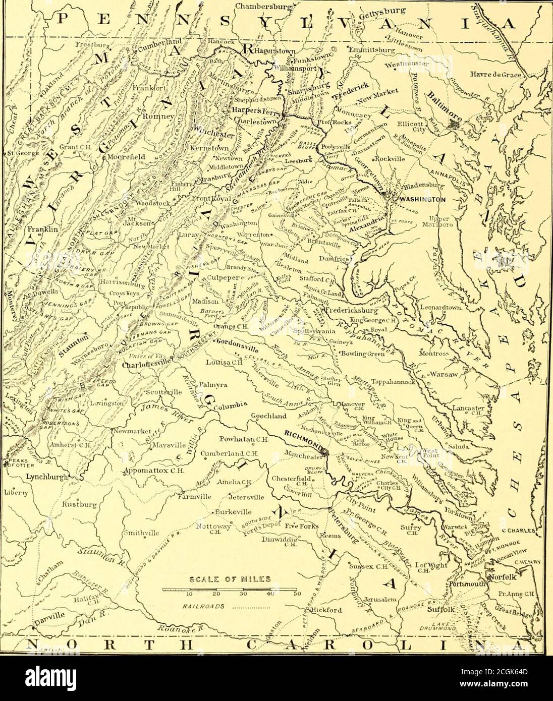 . Battles and leaders of the Civil War : being for the most part contributions by Union and Confederate officers, based upon 'The Century war series.' . HEADQUAKTEKS OF BRIGADIER-GENERAL JOHN SEDGWICK, ON THE LEESBURG TURNHKE, NEAR WASHINGTON.FROM A SKETCH MADE IN JANUARY, 1862. i64 THE PENINSULAR CAMPAIGN.. MAP OF THE VIRGINIA CAMPAIGNS. liim, even for the transaction of ordinary cnrrent bnsiness, and our jiersonalrelations at once ceased. The impatience of the Execntive immediatelybecame extreme, and I can attribute it only to the influence of the newSecretary, who did many things to break u Stock Photohttps://www.alamy.com/image-license-details/?v=1https://www.alamy.com/battles-and-leaders-of-the-civil-war-being-for-the-most-part-contributions-by-union-and-confederate-officers-based-upon-the-century-war-series-headquakteks-of-brigadier-general-john-sedgwick-on-the-leesburg-turnhke-near-washingtonfrom-a-sketch-made-in-january-1862-i64-the-peninsular-campaign-map-of-the-virginia-campaigns-liim-even-for-the-transaction-of-ordinary-cnrrent-bnsiness-and-our-jiersonalrelations-at-once-ceased-the-impatience-of-the-execntive-immediatelybecame-extreme-and-i-can-attribute-it-only-to-the-influence-of-the-newsecretary-who-did-many-things-to-break-u-image371674141.html
RM2CGK64D–. Battles and leaders of the Civil War : being for the most part contributions by Union and Confederate officers, based upon 'The Century war series.' . HEADQUAKTEKS OF BRIGADIER-GENERAL JOHN SEDGWICK, ON THE LEESBURG TURNHKE, NEAR WASHINGTON.FROM A SKETCH MADE IN JANUARY, 1862. i64 THE PENINSULAR CAMPAIGN.. MAP OF THE VIRGINIA CAMPAIGNS. liim, even for the transaction of ordinary cnrrent bnsiness, and our jiersonalrelations at once ceased. The impatience of the Execntive immediatelybecame extreme, and I can attribute it only to the influence of the newSecretary, who did many things to break u
![A map of Spain, with the following place names, in bold: Galicia; Asturias; Valladolid; Leon; Burgos; Iberia; Zamora; Salamanca and Segovia. A new map of Spain and Portugal ... compiled by Jasper Nantiat. London : Published by W. Faden ... Charing Cross, Jan. 1st. 1810. 1 map on 4 sheets : hand col ; 110x154cm., on sheets 53x84cm.; Scale [ca. 1:860 000]. British miles, 80 [=146mm]. Source: Maps C.12.f.4. Sheet 1. Stock Photo A map of Spain, with the following place names, in bold: Galicia; Asturias; Valladolid; Leon; Burgos; Iberia; Zamora; Salamanca and Segovia. A new map of Spain and Portugal ... compiled by Jasper Nantiat. London : Published by W. Faden ... Charing Cross, Jan. 1st. 1810. 1 map on 4 sheets : hand col ; 110x154cm., on sheets 53x84cm.; Scale [ca. 1:860 000]. British miles, 80 [=146mm]. Source: Maps C.12.f.4. Sheet 1. Stock Photo](https://c8.alamy.com/comp/R556T4/a-map-of-spain-with-the-following-place-names-in-bold-galicia-asturias-valladolid-leon-burgos-iberia-zamora-salamanca-and-segovia-a-new-map-of-spain-and-portugal-compiled-by-jasper-nantiat-london-published-by-w-faden-charing-cross-jan-1st-1810-1-map-on-4-sheets-hand-col-110x154cm-on-sheets-53x84cm-scale-ca-1860-000-british-miles-80-=146mm-source-maps-c12f4-sheet-1-R556T4.jpg) A map of Spain, with the following place names, in bold: Galicia; Asturias; Valladolid; Leon; Burgos; Iberia; Zamora; Salamanca and Segovia. A new map of Spain and Portugal ... compiled by Jasper Nantiat. London : Published by W. Faden ... Charing Cross, Jan. 1st. 1810. 1 map on 4 sheets : hand col ; 110x154cm., on sheets 53x84cm.; Scale [ca. 1:860 000]. British miles, 80 [=146mm]. Source: Maps C.12.f.4. Sheet 1. Stock Photohttps://www.alamy.com/image-license-details/?v=1https://www.alamy.com/a-map-of-spain-with-the-following-place-names-in-bold-galicia-asturias-valladolid-leon-burgos-iberia-zamora-salamanca-and-segovia-a-new-map-of-spain-and-portugal-compiled-by-jasper-nantiat-london-published-by-w-faden-charing-cross-jan-1st-1810-1-map-on-4-sheets-hand-col-110x154cm-on-sheets-53x84cm-scale-ca-1860-000-british-miles-80-=146mm-source-maps-c12f4-sheet-1-image226923204.html
A map of Spain, with the following place names, in bold: Galicia; Asturias; Valladolid; Leon; Burgos; Iberia; Zamora; Salamanca and Segovia. A new map of Spain and Portugal ... compiled by Jasper Nantiat. London : Published by W. Faden ... Charing Cross, Jan. 1st. 1810. 1 map on 4 sheets : hand col ; 110x154cm., on sheets 53x84cm.; Scale [ca. 1:860 000]. British miles, 80 [=146mm]. Source: Maps C.12.f.4. Sheet 1. Stock Photohttps://www.alamy.com/image-license-details/?v=1https://www.alamy.com/a-map-of-spain-with-the-following-place-names-in-bold-galicia-asturias-valladolid-leon-burgos-iberia-zamora-salamanca-and-segovia-a-new-map-of-spain-and-portugal-compiled-by-jasper-nantiat-london-published-by-w-faden-charing-cross-jan-1st-1810-1-map-on-4-sheets-hand-col-110x154cm-on-sheets-53x84cm-scale-ca-1860-000-british-miles-80-=146mm-source-maps-c12f4-sheet-1-image226923204.htmlRMR556T4–A map of Spain, with the following place names, in bold: Galicia; Asturias; Valladolid; Leon; Burgos; Iberia; Zamora; Salamanca and Segovia. A new map of Spain and Portugal ... compiled by Jasper Nantiat. London : Published by W. Faden ... Charing Cross, Jan. 1st. 1810. 1 map on 4 sheets : hand col ; 110x154cm., on sheets 53x84cm.; Scale [ca. 1:860 000]. British miles, 80 [=146mm]. Source: Maps C.12.f.4. Sheet 1.
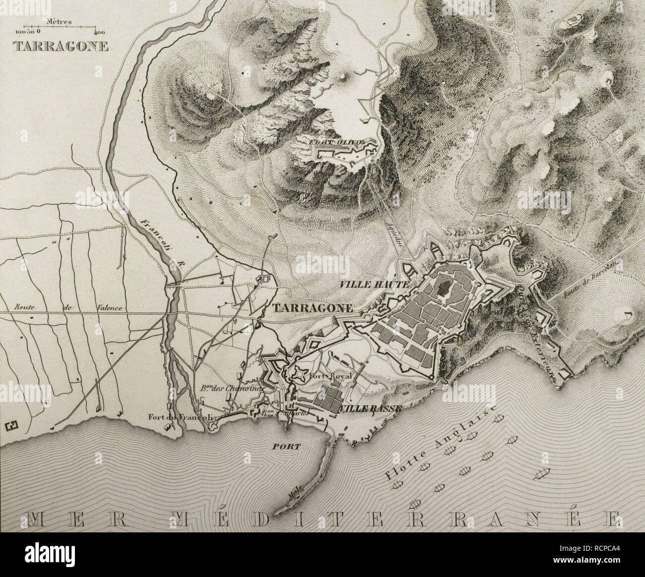 Napoleonic map. Siege of Tarragona (Catalonia, Spain). Tarragona was besieged from 5 May to 29 June 1811. Troops belonging to the French Army of Aragon, commanded by General Suchet, fought against a Spanish garrison led by Lieutenant General Juan Senen de Contreras. A British naval squadron commanded by Admiral Edward Codrington harassed the French besiegers with cannon fire. The city was assaulted and occupied. The Peninsular War. Atlas de l'Histoire du Consulat et de l'Empire. History of the Consulate and the Empire of France under Napoleon by Marie Joseph Louis Adolphe Thiers (1797-1877). D Stock Photohttps://www.alamy.com/image-license-details/?v=1https://www.alamy.com/napoleonic-map-siege-of-tarragona-catalonia-spain-tarragona-was-besieged-from-5-may-to-29-june-1811-troops-belonging-to-the-french-army-of-aragon-commanded-by-general-suchet-fought-against-a-spanish-garrison-led-by-lieutenant-general-juan-senen-de-contreras-a-british-naval-squadron-commanded-by-admiral-edward-codrington-harassed-the-french-besiegers-with-cannon-fire-the-city-was-assaulted-and-occupied-the-peninsular-war-atlas-de-lhistoire-du-consulat-et-de-lempire-history-of-the-consulate-and-the-empire-of-france-under-napoleon-by-marie-joseph-louis-adolphe-thiers-1797-1877-d-image231603292.html
RMRCPCA4–Napoleonic map. Siege of Tarragona (Catalonia, Spain). Tarragona was besieged from 5 May to 29 June 1811. Troops belonging to the French Army of Aragon, commanded by General Suchet, fought against a Spanish garrison led by Lieutenant General Juan Senen de Contreras. A British naval squadron commanded by Admiral Edward Codrington harassed the French besiegers with cannon fire. The city was assaulted and occupied. The Peninsular War. Atlas de l'Histoire du Consulat et de l'Empire. History of the Consulate and the Empire of France under Napoleon by Marie Joseph Louis Adolphe Thiers (1797-1877). D
 A history of the Peninsular War (1902) Stock Photohttps://www.alamy.com/image-license-details/?v=1https://www.alamy.com/stock-photo-a-history-of-the-peninsular-war-1902-96748020.html
RMFHB72C–A history of the Peninsular War (1902)
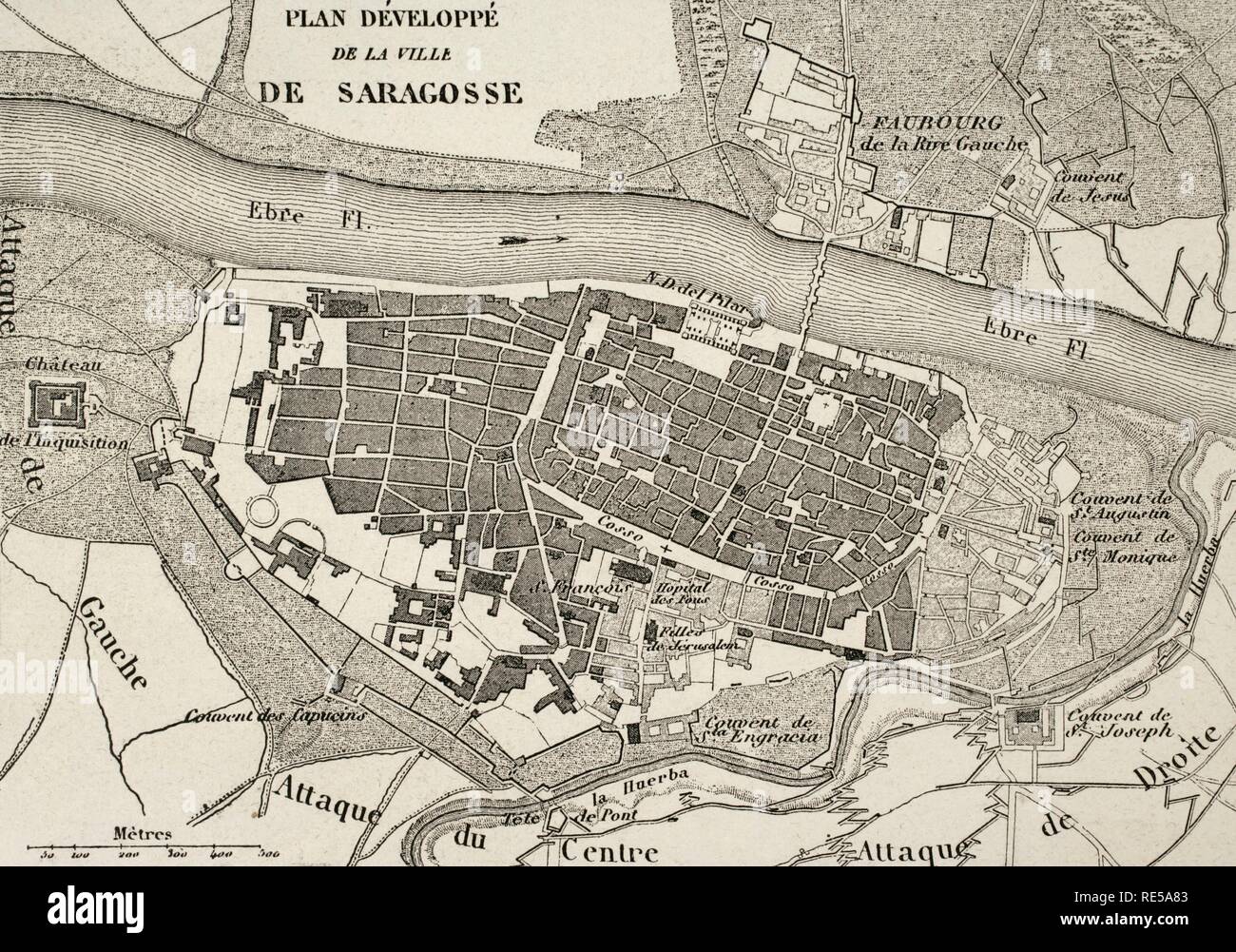 Napoleonic map.City of Saragossa, Aragon, Spain. Edited in 1864. During the War of Spanish Independence, the city suffered two sieges, 1808 and 1809. Atlas de l'Histoire du Consulat et de l'Empire. History of the Consulate and the Empire of France under Napoleon by Marie Joseph Louis Adolphe Thiers (1797-1877). Drawings by Dufour, engravings by Dyonnet. Edited in Paris, 1864. Stock Photohttps://www.alamy.com/image-license-details/?v=1https://www.alamy.com/napoleonic-mapcity-of-saragossa-aragon-spain-edited-in-1864-during-the-war-of-spanish-independence-the-city-suffered-two-sieges-1808-and-1809-atlas-de-lhistoire-du-consulat-et-de-lempire-history-of-the-consulate-and-the-empire-of-france-under-napoleon-by-marie-joseph-louis-adolphe-thiers-1797-1877-drawings-by-dufour-engravings-by-dyonnet-edited-in-paris-1864-image232457795.html
RMRE5A83–Napoleonic map.City of Saragossa, Aragon, Spain. Edited in 1864. During the War of Spanish Independence, the city suffered two sieges, 1808 and 1809. Atlas de l'Histoire du Consulat et de l'Empire. History of the Consulate and the Empire of France under Napoleon by Marie Joseph Louis Adolphe Thiers (1797-1877). Drawings by Dufour, engravings by Dyonnet. Edited in Paris, 1864.
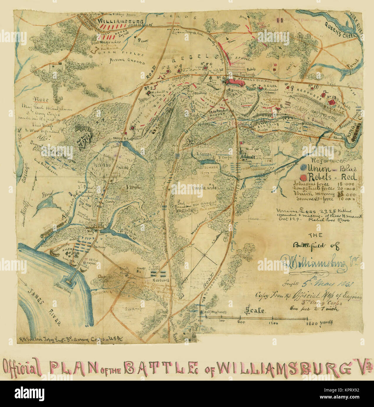 The Battlefield of Williamsburg, Va. AKA the Battle of Fort Magruder Stock Photohttps://www.alamy.com/image-license-details/?v=1https://www.alamy.com/stock-image-the-battlefield-of-williamsburg-va-aka-the-battle-of-fort-magruder-168941278.html
RMKPRX92–The Battlefield of Williamsburg, Va. AKA the Battle of Fort Magruder
 Battle of Albuera, 16 May 1811, Peninsular War, Spain, Peninsular War, From British Battles on Land and Sea by James Grant Stock Photohttps://www.alamy.com/image-license-details/?v=1https://www.alamy.com/battle-of-albuera-16-may-1811-peninsular-war-spain-peninsular-war-from-british-battles-on-land-and-sea-by-james-grant-image401809180.html
RM2E9KYKT–Battle of Albuera, 16 May 1811, Peninsular War, Spain, Peninsular War, From British Battles on Land and Sea by James Grant
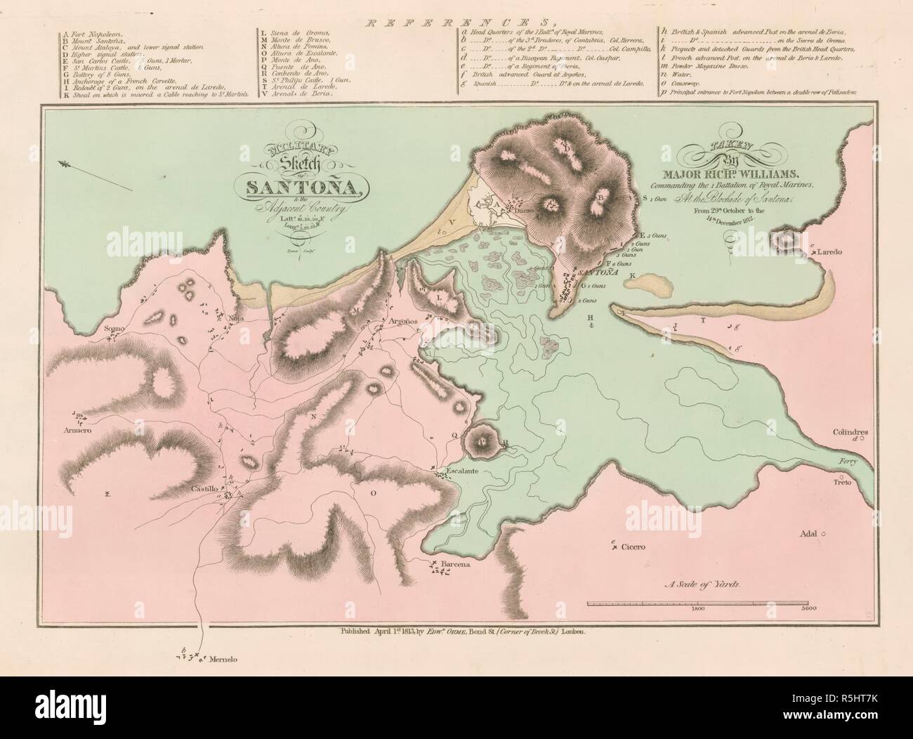 Napoleonic Wars map showing positions of British and French forces during the blockade of Santoña 1812. Relief shown by hachuring. Includes towns, villages, rivers, mountains, defences, batteries, a powder magazine, and positions of troops. Includes an engraving note: 'Rymer Sculpt.' Includes latitude and longitude of Santoña: 'Latte. 43°26'50' N. Longe. 3°29'35' W.' Oriented with the North towards the left. Includes a key. . MILITARY Sketch OF SANTOÑA, & the Adjacent Country. / TAKEN By MAJOR RICHD. WILLIAMS, Commanding the 1 Battalion of Royal Marines. At the Blockade of Santona. Stock Photohttps://www.alamy.com/image-license-details/?v=1https://www.alamy.com/napoleonic-wars-map-showing-positions-of-british-and-french-forces-during-the-blockade-of-santoa-1812-relief-shown-by-hachuring-includes-towns-villages-rivers-mountains-defences-batteries-a-powder-magazine-and-positions-of-troops-includes-an-engraving-note-rymer-sculpt-includes-latitude-and-longitude-of-santoa-latte-432650-n-longe-32935-w-oriented-with-the-north-towards-the-left-includes-a-key-military-sketch-of-santoa-the-adjacent-country-taken-by-major-richd-williams-commanding-the-1-battalion-of-royal-marines-at-the-blockade-of-santona-image227200279.html
RMR5HT7K–Napoleonic Wars map showing positions of British and French forces during the blockade of Santoña 1812. Relief shown by hachuring. Includes towns, villages, rivers, mountains, defences, batteries, a powder magazine, and positions of troops. Includes an engraving note: 'Rymer Sculpt.' Includes latitude and longitude of Santoña: 'Latte. 43°26'50' N. Longe. 3°29'35' W.' Oriented with the North towards the left. Includes a key. . MILITARY Sketch OF SANTOÑA, & the Adjacent Country. / TAKEN By MAJOR RICHD. WILLIAMS, Commanding the 1 Battalion of Royal Marines. At the Blockade of Santona.
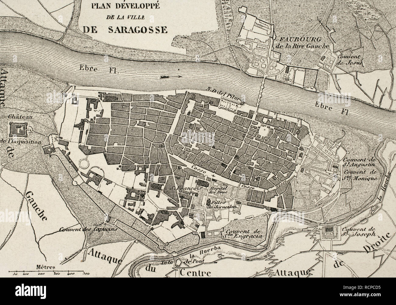 Napoleonic map.City of Saragossa, Aragon, Spain. Edited in 1864. During the War of Spanish Independence, the city suffered two sieges, 1808 and 1809. Atlas de l'Histoire du Consulat et de l'Empire. History of the Consulate and the Empire of France under Napoleon by Marie Joseph Louis Adolphe Thiers (1797-1877). Drawings by Dufour, engravings by Dyonnet. Edited in Paris, 1864. Stock Photohttps://www.alamy.com/image-license-details/?v=1https://www.alamy.com/napoleonic-mapcity-of-saragossa-aragon-spain-edited-in-1864-during-the-war-of-spanish-independence-the-city-suffered-two-sieges-1808-and-1809-atlas-de-lhistoire-du-consulat-et-de-lempire-history-of-the-consulate-and-the-empire-of-france-under-napoleon-by-marie-joseph-louis-adolphe-thiers-1797-1877-drawings-by-dufour-engravings-by-dyonnet-edited-in-paris-1864-image231603377.html
RMRCPCD5–Napoleonic map.City of Saragossa, Aragon, Spain. Edited in 1864. During the War of Spanish Independence, the city suffered two sieges, 1808 and 1809. Atlas de l'Histoire du Consulat et de l'Empire. History of the Consulate and the Empire of France under Napoleon by Marie Joseph Louis Adolphe Thiers (1797-1877). Drawings by Dufour, engravings by Dyonnet. Edited in Paris, 1864.
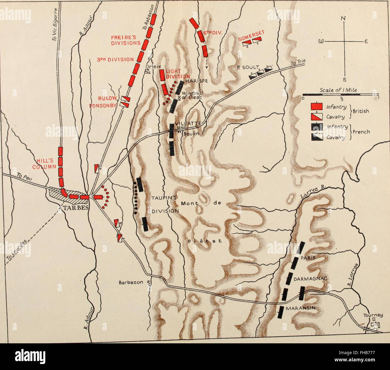 A history of the Peninsular War (1902) Stock Photohttps://www.alamy.com/image-license-details/?v=1https://www.alamy.com/stock-photo-a-history-of-the-peninsular-war-1902-96748155.html
RMFHB777–A history of the Peninsular War (1902)
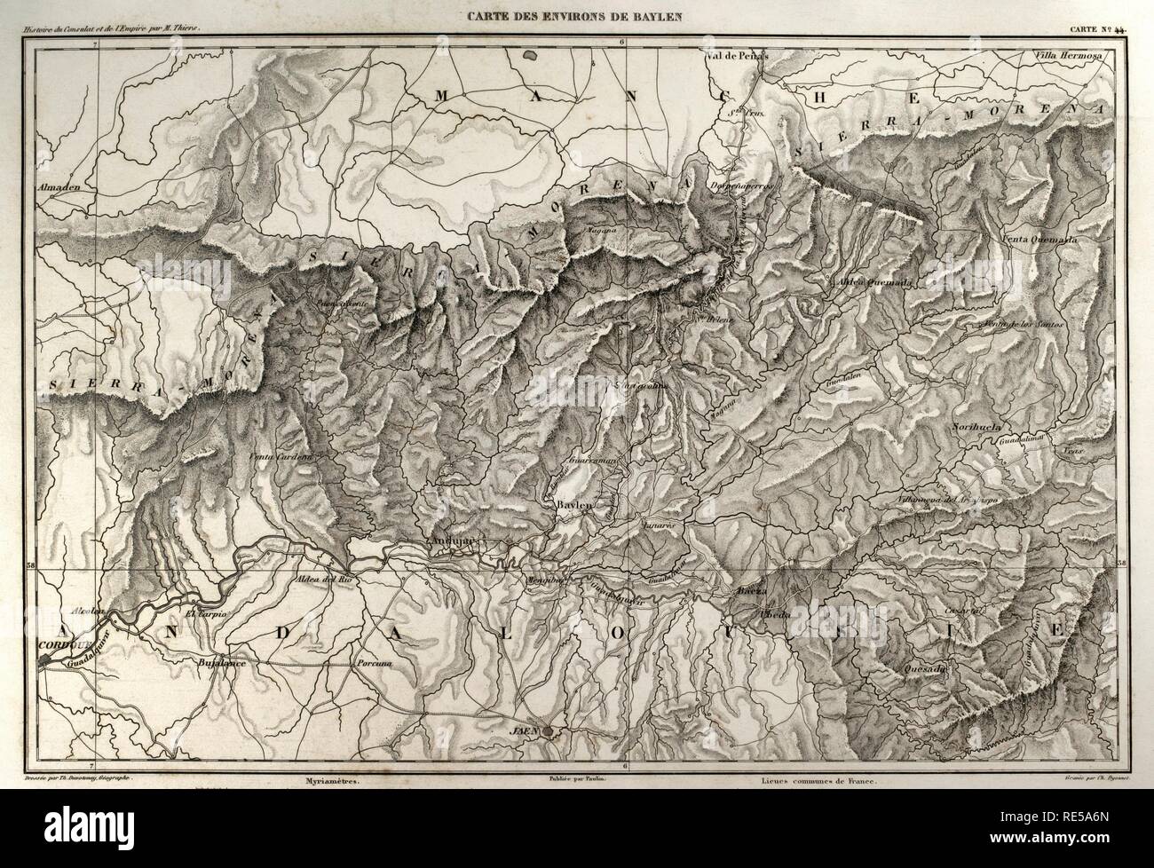 Napolenic map. Surrounding of the town of Bailen (province of Jaen, Andalusia, Spain). During the War of Spanish Independence it took place a battle in Bailen, the first defeat of the French army, 19 th July, 1808. Atlas de l'Histoire du Consulat et de l'Empire. History of the Consulate and the Empire of France under Napoleon by Marie Joseph Louis Adolphe Thiers (1797-1877). Drawings by Dufour, engravings by Dyonnet. Edited in Paris, 1864. Stock Photohttps://www.alamy.com/image-license-details/?v=1https://www.alamy.com/napolenic-map-surrounding-of-the-town-of-bailen-province-of-jaen-andalusia-spain-during-the-war-of-spanish-independence-it-took-place-a-battle-in-bailen-the-first-defeat-of-the-french-army-19-th-july-1808-atlas-de-lhistoire-du-consulat-et-de-lempire-history-of-the-consulate-and-the-empire-of-france-under-napoleon-by-marie-joseph-louis-adolphe-thiers-1797-1877-drawings-by-dufour-engravings-by-dyonnet-edited-in-paris-1864-image232457757.html
RMRE5A6N–Napolenic map. Surrounding of the town of Bailen (province of Jaen, Andalusia, Spain). During the War of Spanish Independence it took place a battle in Bailen, the first defeat of the French army, 19 th July, 1808. Atlas de l'Histoire du Consulat et de l'Empire. History of the Consulate and the Empire of France under Napoleon by Marie Joseph Louis Adolphe Thiers (1797-1877). Drawings by Dufour, engravings by Dyonnet. Edited in Paris, 1864.
 Siege of Yorktown Stock Photohttps://www.alamy.com/image-license-details/?v=1https://www.alamy.com/stock-image-siege-of-yorktown-168941291.html
RMKPRX9F–Siege of Yorktown
 Battle of Fuentes de Oñoro, 3–5 May 1811, Spain, Peninsular War, From British Battles on Land and Sea by James Grant Stock Photohttps://www.alamy.com/image-license-details/?v=1https://www.alamy.com/battle-of-fuentes-de-ooro-35-may-1811-spain-peninsular-war-from-british-battles-on-land-and-sea-by-james-grant-image401809043.html
RM2E9KYEY–Battle of Fuentes de Oñoro, 3–5 May 1811, Spain, Peninsular War, From British Battles on Land and Sea by James Grant
![A 19th century map of the coast of France and Spain from San Sebastian to the mouth of the River Gironde. . Also, the great post roads from Bayonne to Bordeaux. . The coast of France and Spain from San Sebastian to the mouth of the River Gironde. Also, the great post roads from Bayonne to Bordeaux. Illustrative of the operations of the Marquis of Wellington. London : Published by J. Luffman, 377, Strand, Jan.y 1.st 1814. 1 map : hand col ; 40 x 22cm.; Scale [ca. 1:600 000]. Miles, 52 [= 42mm]. Source: Maps CC.5.a.339. Author: Luffmann, John. Stock Photo A 19th century map of the coast of France and Spain from San Sebastian to the mouth of the River Gironde. . Also, the great post roads from Bayonne to Bordeaux. . The coast of France and Spain from San Sebastian to the mouth of the River Gironde. Also, the great post roads from Bayonne to Bordeaux. Illustrative of the operations of the Marquis of Wellington. London : Published by J. Luffman, 377, Strand, Jan.y 1.st 1814. 1 map : hand col ; 40 x 22cm.; Scale [ca. 1:600 000]. Miles, 52 [= 42mm]. Source: Maps CC.5.a.339. Author: Luffmann, John. Stock Photo](https://c8.alamy.com/comp/R50HDH/a-19th-century-map-of-the-coast-of-france-and-spain-from-san-sebastian-to-the-mouth-of-the-river-gironde-also-the-great-post-roads-from-bayonne-to-bordeaux-the-coast-of-france-and-spain-from-san-sebastian-to-the-mouth-of-the-river-gironde-also-the-great-post-roads-from-bayonne-to-bordeaux-illustrative-of-the-operations-of-the-marquis-of-wellington-london-published-by-j-luffman-377-strand-jany-1st-1814-1-map-hand-col-40-x-22cm-scale-ca-1600-000-miles-52-=-42mm-source-maps-cc5a339-author-luffmann-john-R50HDH.jpg) A 19th century map of the coast of France and Spain from San Sebastian to the mouth of the River Gironde. . Also, the great post roads from Bayonne to Bordeaux. . The coast of France and Spain from San Sebastian to the mouth of the River Gironde. Also, the great post roads from Bayonne to Bordeaux. Illustrative of the operations of the Marquis of Wellington. London : Published by J. Luffman, 377, Strand, Jan.y 1.st 1814. 1 map : hand col ; 40 x 22cm.; Scale [ca. 1:600 000]. Miles, 52 [= 42mm]. Source: Maps CC.5.a.339. Author: Luffmann, John. Stock Photohttps://www.alamy.com/image-license-details/?v=1https://www.alamy.com/a-19th-century-map-of-the-coast-of-france-and-spain-from-san-sebastian-to-the-mouth-of-the-river-gironde-also-the-great-post-roads-from-bayonne-to-bordeaux-the-coast-of-france-and-spain-from-san-sebastian-to-the-mouth-of-the-river-gironde-also-the-great-post-roads-from-bayonne-to-bordeaux-illustrative-of-the-operations-of-the-marquis-of-wellington-london-published-by-j-luffman-377-strand-jany-1st-1814-1-map-hand-col-40-x-22cm-scale-ca-1600-000-miles-52-=-42mm-source-maps-cc5a339-author-luffmann-john-image226821773.html
A 19th century map of the coast of France and Spain from San Sebastian to the mouth of the River Gironde. . Also, the great post roads from Bayonne to Bordeaux. . The coast of France and Spain from San Sebastian to the mouth of the River Gironde. Also, the great post roads from Bayonne to Bordeaux. Illustrative of the operations of the Marquis of Wellington. London : Published by J. Luffman, 377, Strand, Jan.y 1.st 1814. 1 map : hand col ; 40 x 22cm.; Scale [ca. 1:600 000]. Miles, 52 [= 42mm]. Source: Maps CC.5.a.339. Author: Luffmann, John. Stock Photohttps://www.alamy.com/image-license-details/?v=1https://www.alamy.com/a-19th-century-map-of-the-coast-of-france-and-spain-from-san-sebastian-to-the-mouth-of-the-river-gironde-also-the-great-post-roads-from-bayonne-to-bordeaux-the-coast-of-france-and-spain-from-san-sebastian-to-the-mouth-of-the-river-gironde-also-the-great-post-roads-from-bayonne-to-bordeaux-illustrative-of-the-operations-of-the-marquis-of-wellington-london-published-by-j-luffman-377-strand-jany-1st-1814-1-map-hand-col-40-x-22cm-scale-ca-1600-000-miles-52-=-42mm-source-maps-cc5a339-author-luffmann-john-image226821773.htmlRMR50HDH–A 19th century map of the coast of France and Spain from San Sebastian to the mouth of the River Gironde. . Also, the great post roads from Bayonne to Bordeaux. . The coast of France and Spain from San Sebastian to the mouth of the River Gironde. Also, the great post roads from Bayonne to Bordeaux. Illustrative of the operations of the Marquis of Wellington. London : Published by J. Luffman, 377, Strand, Jan.y 1.st 1814. 1 map : hand col ; 40 x 22cm.; Scale [ca. 1:600 000]. Miles, 52 [= 42mm]. Source: Maps CC.5.a.339. Author: Luffmann, John.
 A history of the Peninsular War (1902) Stock Photohttps://www.alamy.com/image-license-details/?v=1https://www.alamy.com/stock-photo-a-history-of-the-peninsular-war-1902-96747986.html
RMFHB716–A history of the Peninsular War (1902)
 Union and Rebel works Yorktown, Va. 1862 Stock Photohttps://www.alamy.com/image-license-details/?v=1https://www.alamy.com/stock-image-union-and-rebel-works-yorktown-va-1862-168941553.html
RMKPRXJW–Union and Rebel works Yorktown, Va. 1862
 The Battle of Talavera, 28 July 1809, Talavera de la Reina, Spain, Peninsular War, From British Battles on Land and Sea by James Grant Stock Photohttps://www.alamy.com/image-license-details/?v=1https://www.alamy.com/the-battle-of-talavera-28-july-1809-talavera-de-la-reina-spain-peninsular-war-from-british-battles-on-land-and-sea-by-james-grant-image401809002.html
RM2E9KYDE–The Battle of Talavera, 28 July 1809, Talavera de la Reina, Spain, Peninsular War, From British Battles on Land and Sea by James Grant
 A history of the Peninsular War (1902) Stock Photohttps://www.alamy.com/image-license-details/?v=1https://www.alamy.com/stock-photo-a-history-of-the-peninsular-war-1902-96747950.html
RMFHB6YX–A history of the Peninsular War (1902)
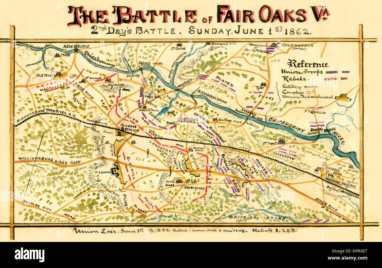 Battle of Seven Pines Stock Photohttps://www.alamy.com/image-license-details/?v=1https://www.alamy.com/stock-image-battle-of-seven-pines-168941440.html
RMKPRXET–Battle of Seven Pines
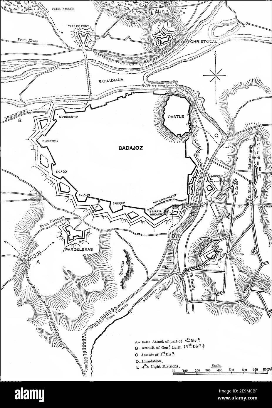 The Siege of Badajoz, 16 March – 6 April 1812, Peninsular War, From British Battles on Land and Sea by James Grant Stock Photohttps://www.alamy.com/image-license-details/?v=1https://www.alamy.com/the-siege-of-badajoz-16-march-6-april-1812-peninsular-war-from-british-battles-on-land-and-sea-by-james-grant-image401809731.html
RM2E9M0BF–The Siege of Badajoz, 16 March – 6 April 1812, Peninsular War, From British Battles on Land and Sea by James Grant
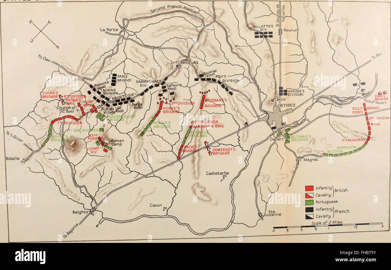 A history of the Peninsular War (1902) Stock Photohttps://www.alamy.com/image-license-details/?v=1https://www.alamy.com/stock-photo-a-history-of-the-peninsular-war-1902-96748119.html
RMFHB75Y–A history of the Peninsular War (1902)
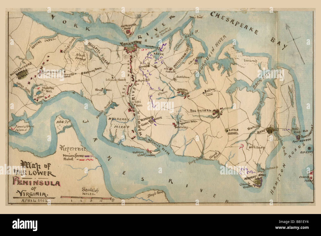 Peninsular Campaign Stock Photohttps://www.alamy.com/image-license-details/?v=1https://www.alamy.com/stock-photo-peninsular-campaign-24005272.html
RMBB1EY4–Peninsular Campaign
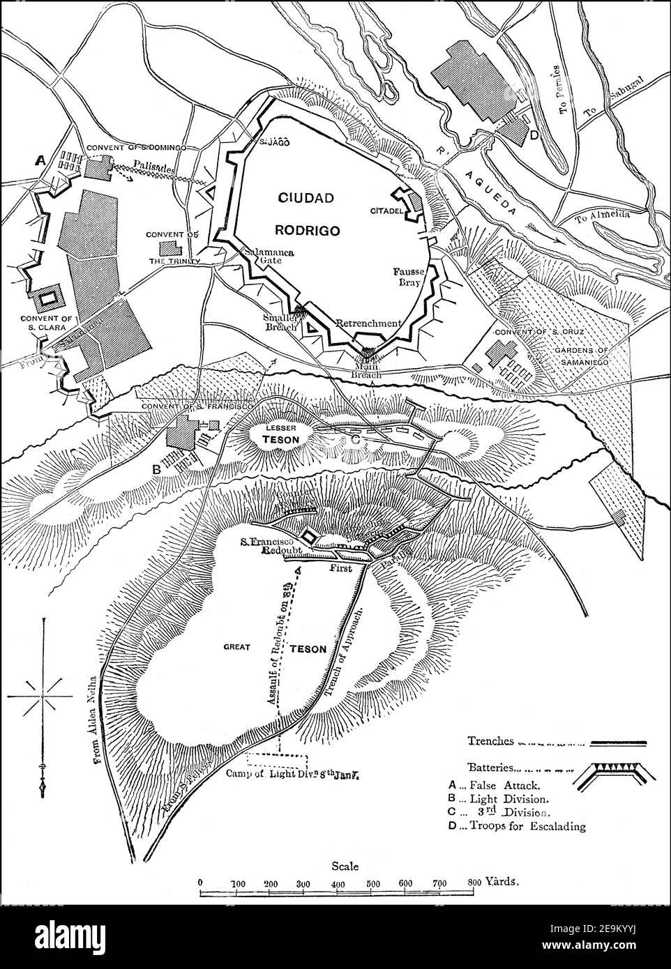 Siege of Ciudad Rodrigo, Wellington’s campaign in Spain, 19 January 1812, Peninsular War, From British Battles on Land and Sea by James Grant Stock Photohttps://www.alamy.com/image-license-details/?v=1https://www.alamy.com/siege-of-ciudad-rodrigo-wellingtons-campaign-in-spain-19-january-1812-peninsular-war-from-british-battles-on-land-and-sea-by-james-grant-image401809398.html
RM2E9KYYJ–Siege of Ciudad Rodrigo, Wellington’s campaign in Spain, 19 January 1812, Peninsular War, From British Battles on Land and Sea by James Grant