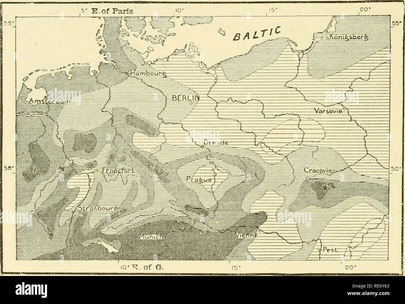
. The earth and its inhabitants ... Geography. 162 GEEMANT. the one tributary to the Danube, the other to the Rhine—are separated only by a flat level, presenting no difficulty to the cutting of a canal. This plain thus forms g, reffion of transition between the basins of the Rhine and the Danube. The rivers of Northern Germany present a remarkable parallelism in their course. The Weser, the Elbe, the Oder, and the Vistula flow in the same direction as the Rhine below Mayence. The analogy presented by some of the curves described by these rivers is truly striking, and clearly points to a great
Image details
Contributor:
The Book Worm / Alamy Stock PhotoImage ID:
RE6Y63File size:
7.1 MB (459.6 KB Compressed download)Releases:
Model - no | Property - noDo I need a release?Dimensions:
1914 x 1305 px | 32.4 x 22.1 cm | 12.8 x 8.7 inches | 150dpiMore information:
This image is a public domain image, which means either that copyright has expired in the image or the copyright holder has waived their copyright. Alamy charges you a fee for access to the high resolution copy of the image.
This image could have imperfections as it’s either historical or reportage.
. The earth and its inhabitants ... Geography. 162 GEEMANT. the one tributary to the Danube, the other to the Rhine—are separated only by a flat level, presenting no difficulty to the cutting of a canal. This plain thus forms g, reffion of transition between the basins of the Rhine and the Danube. The rivers of Northern Germany present a remarkable parallelism in their course. The Weser, the Elbe, the Oder, and the Vistula flow in the same direction as the Rhine below Mayence. The analogy presented by some of the curves described by these rivers is truly striking, and clearly points to a great uniformity in the geological agencies. But not only is the course of these rivers a parallel one now, it appears to have been so in a remote geological age. There was a time when the Elbe, below Magdeburg, continued its normal course towards the north-west, and found its way through the Aller, now a tributary of Fig. 96.—Eain Map of Germany. According to Putzg-er.. Annual Rainfall In Inches m the Weser, into the sea. The Oder, instead of sweeping round to the north on reaching Frankfort, continued towards the north-west, and joining the Elbe, was tributary to the North Sea. At that time it must have flowed along what is now the channel of the Spree, a river likened by a modern writer to " a dwarf concealed in the armour of a giant." The Vistula, M'hich now discharges into the Frische Hafi*, turned to the west, and, by way of the swampy valley now occupied by the AVarte and the Netze, it reached the Oder. The Memel (Niémen), which now enters the Kurlsche Haâ", at that time flowed along the valley of the Pregel into the Frische Hafl". These changes in the course of the rivers prove that the plain of Northern Germany must have been upheaved in its western part, causing the rivers to swerve round to the east. And, indeed, the marks of a subsidence of the. Please note that these images are extracted from scanned page images that may have been digitally en