···
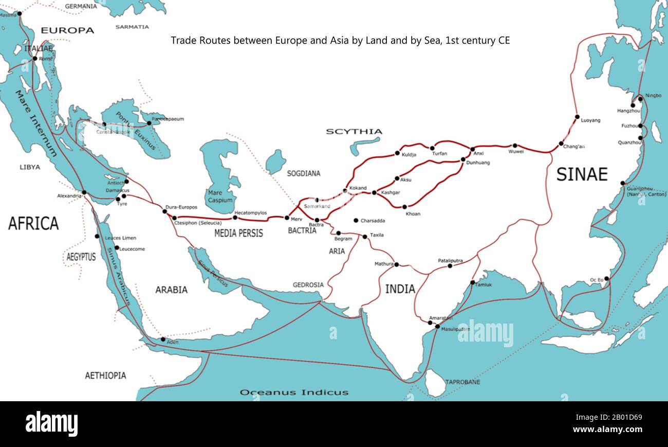
World: Map of Trade Routes between Europe and Asia by Land and by Sea, c. 100 CE, by Shizhao (CC BY 3.0 License). Outline map of the major trade routes between Europe and Asia around 100 CE, including the Silk Road, the Incense Road and the sea routes between Europe, Arabia, India and China. Geographical labels for regions are adapted from the Geography of Ptolemy (c. 150 CE), some trading centre names date from later (c. 400 CE). Image details File size:
50 MB (595.7 KB Compressed download)
Open your image file to the full size using image processing software.
Dimensions:
5400 x 3238 px | 45.7 x 27.4 cm | 18 x 10.8 inches | 300dpi
Date taken:
22 August 2011
More information:
This image could have imperfections as it’s either historical or reportage.
Search stock photos by tags
Similar stock images A map showing a network of medieval trade routes, including the Silk Road (connecting East and West between the 2nd century BCE and the 18th century) and various sea trade routes. The areas in darker yellow indicate the extent of the Islamic world in 1500. Stock Photo https://www.alamy.com/image-license-details/?v=1 https://www.alamy.com/a-map-showing-a-network-of-medieval-trade-routes-including-the-silk-road-connecting-east-and-west-between-the-2nd-century-bce-and-the-18th-century-and-various-sea-trade-routes-the-areas-in-darker-yellow-indicate-the-extent-of-the-islamic-world-in-1500-image353173876.html RM 2BEGCTM – A map showing a network of medieval trade routes, including the Silk Road (connecting East and West between the 2nd century BCE and the 18th century) and various sea trade routes. The areas in darker yellow indicate the extent of the Islamic world in 1500. Conceptual caption One Belt One Road. Word for Building trade routes between China and other countries Stock Photo https://www.alamy.com/image-license-details/?v=1 https://www.alamy.com/conceptual-caption-one-belt-one-road-word-for-building-trade-routes-between-china-and-other-countries-image550423742.html RF 2PYDY2P – Conceptual caption One Belt One Road. Word for Building trade routes between China and other countries Conceptual display One Belt One Road. Internet Concept Building trade routes between China and other countries Stock Photo https://www.alamy.com/image-license-details/?v=1 https://www.alamy.com/conceptual-display-one-belt-one-road-internet-concept-building-trade-routes-between-china-and-other-countries-image547496422.html RM 2PPMH7J – Conceptual display One Belt One Road. Internet Concept Building trade routes between China and other countries Photograph of a map depicting the main trade routes of the United States, Canada, Mexico, and the West Indies. The map highlights the strategic economic connections between these regions during the early twentieth century. Notations suggest that this image was taken on February 19, 1921, by photographer HOMBER 62545. Stock Photo https://www.alamy.com/image-license-details/?v=1 https://www.alamy.com/photograph-of-a-map-depicting-the-main-trade-routes-of-the-united-states-canada-mexico-and-the-west-indies-the-map-highlights-the-strategic-economic-connections-between-these-regions-during-the-early-twentieth-century-notations-suggest-that-this-image-was-taken-on-february-19-1921-by-photographer-homber-62545-image558472560.html RM 2RCGHCG – Photograph of a map depicting the main trade routes of the United States, Canada, Mexico, and the West Indies. The map highlights the strategic economic connections between these regions during the early twentieth century. Notations suggest that this image was taken on February 19, 1921, by photographer HOMBER 62545. Text caption presenting One Belt One RoadBuilding trade routes between China and other countries. Business idea Building trade routes between China and other countries Stock Photo https://www.alamy.com/image-license-details/?v=1 https://www.alamy.com/text-caption-presenting-one-belt-one-roadbuilding-trade-routes-between-china-and-other-countries-business-idea-building-trade-routes-between-china-and-other-countries-image547422941.html RM 2PPH7F9 – Text caption presenting One Belt One RoadBuilding trade routes between China and other countries. Business idea Building trade routes between China and other countries Conceptual display One Belt One Road. Word for Building trade routes between China and other countries Stock Photo https://www.alamy.com/image-license-details/?v=1 https://www.alamy.com/conceptual-display-one-belt-one-road-word-for-building-trade-routes-between-china-and-other-countries-image540833681.html RF 2PBW2TH – Conceptual display One Belt One Road. Word for Building trade routes between China and other countries Handwriting text One Belt One Road. Concept meaning Building trade routes between China and other countries. Stock Photo https://www.alamy.com/image-license-details/?v=1 https://www.alamy.com/handwriting-text-one-belt-one-road-concept-meaning-building-trade-routes-between-china-and-other-countries-image223391280.html RF PYC9T0 – Handwriting text One Belt One Road. Concept meaning Building trade routes between China and other countries. A map showing a network of medieval trade routes, including the Silk Road (connecting East and West between the 2nd century BCE and the 18th century) and various sea trade routes. The areas in darker yellow indicate the extent of the Islamic world in 1500. Stock Photo https://www.alamy.com/image-license-details/?v=1 https://www.alamy.com/a-map-showing-a-network-of-medieval-trade-routes-including-the-silk-road-connecting-east-and-west-between-the-2nd-century-bce-and-the-18th-century-and-various-sea-trade-routes-the-areas-in-darker-yellow-indicate-the-extent-of-the-islamic-world-in-1500-image352776147.html RM 2BDX9G3 – A map showing a network of medieval trade routes, including the Silk Road (connecting East and West between the 2nd century BCE and the 18th century) and various sea trade routes. The areas in darker yellow indicate the extent of the Islamic world in 1500. World: Map of Trade Routes between Europe and Asia by Land and by Sea c. 100 CE, with the future location of Dubai on the Arab Gulf indicated, by Shizao (CC BY 3.0 License). Outline map of the major trade routes between Europe and Asia around 100 CE, including the Silk Road, the Incense Road and the sea routes between Europe, Arabia, India and China. Geographical labels for regions are adapted from the Geography of Ptolemy (c. 150 CE), some trading centre names date from later (c. 400 CE). Stock Photo https://www.alamy.com/image-license-details/?v=1 https://www.alamy.com/world-map-of-trade-routes-between-europe-and-asia-by-land-and-by-sea-c-100-ce-with-the-future-location-of-dubai-on-the-arab-gulf-indicated-by-shizao-cc-by-30-license-outline-map-of-the-major-trade-routes-between-europe-and-asia-around-100-ce-including-the-silk-road-the-incense-road-and-the-sea-routes-between-europe-arabia-india-and-china-geographical-labels-for-regions-are-adapted-from-the-geography-of-ptolemy-c-150-ce-some-trading-centre-names-date-from-later-c-400-ce-image344239682.html RM 2B01D6A – World: Map of Trade Routes between Europe and Asia by Land and by Sea c. 100 CE, with the future location of Dubai on the Arab Gulf indicated, by Shizao (CC BY 3.0 License). Outline map of the major trade routes between Europe and Asia around 100 CE, including the Silk Road, the Incense Road and the sea routes between Europe, Arabia, India and China. Geographical labels for regions are adapted from the Geography of Ptolemy (c. 150 CE), some trading centre names date from later (c. 400 CE). Conceptual display One Belt One Road. Word for Building trade routes between China and other countries Stock Photo https://www.alamy.com/image-license-details/?v=1 https://www.alamy.com/conceptual-display-one-belt-one-road-word-for-building-trade-routes-between-china-and-other-countries-image550424626.html RF 2PYE06A – Conceptual display One Belt One Road. Word for Building trade routes between China and other countries Conceptual caption One Belt One Road. Word for Building trade routes between China and other countries Stock Photo https://www.alamy.com/image-license-details/?v=1 https://www.alamy.com/conceptual-caption-one-belt-one-road-word-for-building-trade-routes-between-china-and-other-countries-image540996658.html RF 2PC4EN6 – Conceptual caption One Belt One Road. Word for Building trade routes between China and other countries Handwriting text One Belt One Road. Concept meaning Building trade routes between China and other countries. Stock Photo https://www.alamy.com/image-license-details/?v=1 https://www.alamy.com/handwriting-text-one-belt-one-road-concept-meaning-building-trade-routes-between-china-and-other-countries-image223426300.html RF PYDXEM – Handwriting text One Belt One Road. Concept meaning Building trade routes between China and other countries. 